
I like to do most of my summertime hiking in the high country to avoid the heat, and the bugs. It’s like getting extra, added months of spring. So when the first week of summer rolled around, I thought of that section of Pisgah National Forest that lies between Shining Rock and Middle Prong Wildernesses, surrounded by the Blue Ridge Parkway, Hwy 215, and Black...
Learn More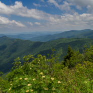
The summer solstice occurs when a planet’s rotational axis, in either northern or southern hemispheres, is most inclined toward the Sun. Most cultures have marked this occasion in some ritualized manner and from time immemorial people have acknowledged the rising of the sun on the summer solstice. At Stonehenge, the heelstone marks the midsummer sunrise as seen...
Learn More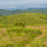
There is a notch between two wildernesses in the Pisgah National Forest high country. Shining Rock Wilderness is to the northeast, and Middle Prong Wilderness is to the west of this pie-shaped cut in the topology. In between are two bald mountaintops that exceed 6,000 feet elevation. To the locals the area is called simply… Black Balsam. The air is fresh (usually),...
Learn More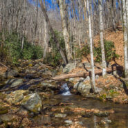
Sometimes the forest roads in national forests make the best hiking trails. Such is the case with FR 5031 in Pisgah National Forest. Located near Courthouse Falls on the far southwestern side of Pisgah, near the boundary with Nantahala National Forest, FR 5031 is a means of getting from a drainage bowl to Farlow Gap on Shuck Ridge. For mountain bikers, you could connect...
Learn More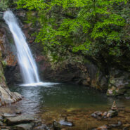
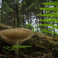
Hidden deep in the woods between Courthouse Ridge and Brushy Ridge in western Pisgah National Forest, Courthouse Creek makes a dramatic plunge through a narrow chute into a natural amphitheater of bedrock, cascading 45 feet into a cold crisp pool. Courthouse Falls is one of the best kept secrets in the “Land of Waterfalls.” Beautiful for its solitude as well...
Learn More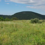
Flat Laurel Creek is in the area just north of the Pisgah Ridge and in between the Shining Rock and Middle Prong Wildernesses. It drains from Sam Knob and Little Sam Knob and runs to the West Fork of the Pigeon River. The trail that bears its name starts at the headwater and travels 3.7 miles around the west side of Little Sam until it meets Hwy. 215 and joins the...
Learn More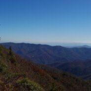
Cold Mountain gained national attention following the publishing of Charles Frazier’s Civil War era novel in 1997. Western NC hiking enthusiasts have known of its appeal for much longer. Cold Mountain is a real mountain that stretches 6030′ and is located in the Shining Rock Wilderness and Pisgah National Forest in North Carolina. You can reach the spur trail...
Learn More
The Middle Prong Wilderness is west of North Carolina Hwy. 215 and north of the Blue Ridge Parkway. It is named after the Middle Prong of the Little Pigeon River that runs through the heart of the wilderness. This is remote territory in the high country near 6000 feet. Prepare yourself for heavy breathing — from exertion, and from natural beauty. Buckeye Gap Trail...
Learn More I am Jeff Clark, founder of Internet Brothers, producer of this blog, and passionate about hiking. I live in Western NC near the Blue Ridge and Great Smoky Mountains. Pisgah and Nantahala National Forests are just out my door, so the content will focus on these areas, but let me know what you would like to see on the site.


Copyright © 2011-2023 Internet Brothers. All Rights Reserved. ISSN 2324-6057
Designed by Elegant Themes | Powered by Wordpress | Logo by Design Aspirations