
Start your morning with the elk rut in Cataloochee Valley. Then gear up for this enchanting deep forest hike that includes mountain creek crossings, giant old growth tulip poplar and hemlock, occasional views of the Smoky Mountains surrounding the valley, and a stroll down memory lane at historic settler homesteads. Enjoy this 10-mile loop in three segments, on three different trails, as you also discover means of accessing other sections of the national park. This is probably my favorite Cataloochee hike as it combines wildlife, good exercise, simply beautiful and grand hardwood forest, and the ubiquitous, burbling Smoky Mountains streams. We had a great time with this loop on Thursday, September 18, 2014 beginning at 8:30AM and ending about 1:45PM. Our plan was to make a loop of the Big Fork Ridge Trail, the Caldwell Fork Trail, and the Rough Fork Trail in a clockwise direction.
Hike Length: 10 miles Hike Duration: 5.25 hours
Hike Configuration: Loop Blaze: None needed.
Hike Rating: Moderate. There is quite a bit of climbing, but all nice and gradual.
Elevation Gain: 2,030 feet Elevation Change: 1,200 feet
Trail Condition: Good. Some mud from horse traffic. Some exposed roots.
Starting Point: Far western end of Cataloochee Road at turnaround.
Trail Traffic: We encountered two other hikers and two rangers doing trail work.
How to Get There: From Asheville, NC take I-40 west to Exit 20, Hwy 276. Turn toward Maggie Valley, then take the first right onto Cove Creek Road. Stay on Cove Creek Rd. to the entrance to Great Smoky Mountains National Park at the Cataloochee Divide. The last mile up on Cove Creek Rd. is gravel. From the Divide it is three more miles of very curvy, downhill gravel road to the junction with Mt. Sterling Rd. and Cataloochee Rd. Turn left to Cataloochee Valley. Go all the way to the dead end of Cataloochee Rd. and park at the turnaround.
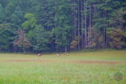
As we approached the west end of Cataloochee Road I heard that unmistakable sound. There’s nothing else that I’ve heard like the bugling of a bull elk in rut. When we passed the Caldwell House and barn we got our first glimpse of them. There were four bulls, perhaps a dozen cows and a few calves enjoying the early morning light in the meadows of Cataloochee Valley. This was another sure sign that Autumn is near.
We simply couldn’t get to the end of the road fast enough, to park the car, get out, and begin taking pictures. The dominant bull was making sure the younger bulls kept their distance from his harem. His clarion call was rich and penetrating, reverberating off the mountains that surround this stunning pasture. He was too far away to count all the points on his rack, but it stood nearly as tall from his head as the distance from his shoulders to the ground. This was a big fella.
We stood and marveled for 10-15 minutes… and then it was over. Suddenly, as if by alarm, they all disappeared into the forest on the north side of the meadow. So too did the tourists, as the bugling call was replaced by the sound of car engines cranking. The show was over for this morning, but we knew when we returned from our hike several hours later, the cars would be lining up for the prime viewing locations of the evening performance.
Now it was time to hike. The Big Fork Ridge trailhead is just a hundred feet east of the Cataloochee Road turnaround. You can see the finish line at the turnaround — the Rough Fork trailhead — but we chose to do the loop clockwise. There is more climbing early on the Big Fork Trail. We wanted to take advantage of fresh legs and cooler air.
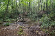
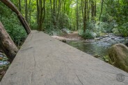
There is a footlog over Rough Fork right at the trailhead… fortunately. When I began my Boogerman hike earlier in the summer, the initial crossing was missing its bridge. Not so today. We brought water shoes just in case some bridges were out like before, but we found that all was well in that department.
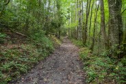
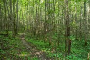
Big Fork Ridge Trail rises 750 feet in its first two miles… a nicely moderate grade. No struggling to climb a steep mountain here. It’s really more of a gentle stroll through a delightful mixed hardwood forest. There is sadness at the grey ghosts — reminders of the once powerful hemlocks that still stand a hundred feet tall — but are now just carcasses. The hemlock woolly adelgid blight has taken its toll in Cataloochee Valley. About half way up, a series of switchbacks makes Big Fork Ridge even easier to manage.
The trail itself is nicely maintained, but is multi-use. Equestrians also use all three trails along this loop, so during especially wet days you’re quite likely to encounter lots of mud. We were fortunate to catch it after a couple consecutive dry days, so the mud throughout the entire length was manageable.
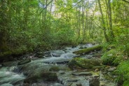
Once you top the ridge it’s right back down the other side about 500 of the feet you just climbed. Listen, as you descend, for the tell-tale sound of rushing water. You’ll know you’re getting close to the Caldwell Fork drainage and the next crossing. It’s about a mile. The Park Service has done a very nice job of building the footlog anchors several feet above trail level to help prevent the bridge washouts that have been experienced further downstream.
Mere minutes after crossing Caldwell Fork you’ll reach the junction with Caldwell Fork Trail. Turning left will take you to the Boogerman Loop, and turning right will continue this journey. There are some nice logs to sit on at the junction, so we paused for a few to enjoy a snack, then continued westerly along Caldwell Fork. Almost immediately there is another junction, this one on the left with McKee Branch Trail. If you are so inclined, McKee Branch will take you to the Learning Center at Purchase Knob, but we continued straight ahead on Caldwell Fork.
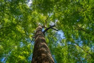
For the next couple hours we thoroughly enjoyed the 3.1 miles of Caldwell Fork Trail. The forest here is some of the most beautiful I have experienced anywhere in the Smokies, a lush two-age (perhaps even three) mix of old growth tulip poplars, and 2nd and 3rd growth oak, maple, birch, beech and buckeye. Man, the buckeyes. This will be a great winter for the wildlife, at least if they enjoy buckeyes. They were everywhere!
With the second consecutive really wet summer, the forest was still incredibly green, displaying that bright verdant sheen that is more common in early May than mid-September. The woods are truly healthy here, with the exception of the poor hemlocks. As you’re walking through you can breathe in the aura of life. It makes the climbing easier.
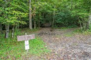
After a mile and a half you’ll reach the junction with Hemphill Bald Trail. Like McKee Branch, this is another connection to the Cataloochee Divide Trail to the scenic Hemphill Bald. Stay on Caldwell Fork, though, to complete this hike. Soon after the junction you will reach backcountry campsite #41 on the right, where we encountered the only other hikers of the day. There is another footlog here as Caldwell Fork provides sustaining water for the campers.
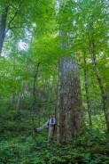
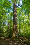
The trail now makes its final push up Big Ridge, though still a nicely moderate ascent. It you take time to pause occasionally and enjoy your surroundings, there really is no huffing and puffing on this hike. Not far past the campsite we passed a couple of Park Rangers coming the other direction. They were out with their trail maintenance equipment looking for downed trees that had fallen across trails. We chatted for a bit as they asked where we had encountered any tree trouble, and then told us about the “Big Poplars” grove we had to look forward to just a few hundred yards ahead.
There is a small sign that announces the “Big Poplars” up a spur trail on the right. It’s only a couple hundred feet off the main trail to a horse tie-off and then the main attraction. There is one tulip poplar in particular that is simply huge. Glorious, grand, enchanting, enlightening. All these words describe this remarkable tree that is still the epitome of good health. It may live another couple centuries.
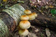
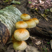
We used the massive roots as comfortable seats and enjoyed perhaps the best trail lunch I’ve ever had. My friend brought chile verde burritos mixed with homemade salsa, one of his wife’s specialties. The experience was captivating. Being in remote forest, at the base of a majestic 6-foot-wide gentle giant, surrounded by fresh mushrooms, moss and lichens, listening to the deep woods quiet, and enjoying a scrumptious meal. Smoky Mountain Nirvana!
Soon after the “Big Poplars,” Caldwell Fork Trail begins a descent to its meeting with Rough Fork Trail. There is no more climbing. As they say, it’s all downhill from here. When you reach the junction you want to turn right on Rough Fork. If you go left, it takes you to Poll Gap on Heintooga Road, high above Cataloochee Valley. From this junction it is 2.9 miles back to the turnaround at the end of Cataloochee Road.
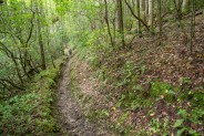
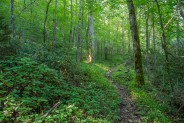
The first half of Rough Fork Trail is a descent of Little Ridge. Plenty of switchbacks make it again only moderately steep, therefore easy on the knees. I can’t stress enough how well-done this loop is from a trail construction perspective, making it easier for those with all levels of hiking experience and stamina. Just as before, over on Big Fork Ridge, when you begin to hear rushing water you are nearing the flat.
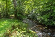
As Rough Fork comes in from the left, and Hurricane Creek drops down from the right, they meet at backcountry campsite #40. From this point on, the last mile and a half is a level meander alongside the babbling, picturesque Rough Fork. The creek will be on your left, and if you look closely along the right side of the trail you’ll see evidence that this land was once farmed by the early Cataloochee settlers. It’s now grown over with saplings, but the forest floor is still somewhat grassy.
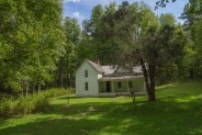
You cross several more footlogs as the trail winds from side-to-side of Rough Fork — and then a half mile from campsite #40 and a mile from the trailhead — you reach Woody House. Constructed in 1880 by Steve Woody, the son of Jonathan Woody, the house was originally built of logs. Later, paneling and extra rooms were added as lumber from sawmills became readily available. A springhouse is also nearby.
The two-story home looks out on an expansive front yard and the pure mountain water of Rough Fork. You are allowed to walk around in the house, including the second floor. Please don’t be one of those who feels the need to add your own graffiti to the already-vandalized walls. It really takes away from the experience of this otherwise attractive historic structure. With your restraint, your grandchildren’s grandchildren will still be able to enjoy memorable Woody House a century from now.
As my friend and I walked the final mile from Woody House back to the car along Rough Fork, we encountered a few families out for a woodsy stroll, and reminisced about everything we had experienced on this fabulous day. I’ll never forget the piercing sound of the bull elk announcing with a bugle call his mastery over the others in the herd. We were able to leave our water shoes in the pack today as we could hike over the streams rather than in them. That was a relief.
The forest here on the west end of Cataloochee Valley is splendid, remarkable, brilliant, impressive, verdant. You can make up some of your own adjectives after you’ve seen it for yourself. The big poplars and hemlocks make it all the more so. It’s also worth remembering what the settler families gave up when they left their homes and heritage in the 1930s, including the Woody’s and Caldwell’s, so that we can enjoy this marvelous national park. I’d have to say this is my favorite hike in the Cataloochee section of Great Smoky Mountains National Park.

The following are paid links. As an Amazon Associate I earn from qualifying purchases.
 I am Jeff Clark, founder of Internet Brothers, producer of this blog, and passionate about hiking. I live in Western NC near the Blue Ridge and Great Smoky Mountains. Pisgah and Nantahala National Forests are just out my door, so the content will focus on these areas, but let me know what you would like to see on the site.


Copyright © 2011-2023 Internet Brothers. All Rights Reserved. ISSN 2324-6057
Designed by Elegant Themes | Powered by Wordpress | Logo by Design Aspirations

