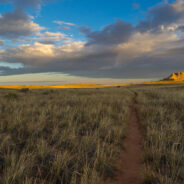
There are lots of little maintenance trails alongside the Blue Ridge Parkway that don’t show up on any trail maps or have any signs to let you know they are there. One of those is a hidden gem in the high country at milepost 420 directly across from the Black Balsam spur road. It’s great for an hour stroll to brighten you senses, or if you’re looking for a quiet and peaceful spot for lunch away from the madness of Graveyard Fields. With magnificent views of Pilot Mountain and Black Balsam and Mt. Pisgah, you will get a...
read moreVenturing more into the central part of Tennessee to the Cumberland Plateau has been a goal of mine for some time. The name “Walls of Jericho” kept cropping up, so that clinched the destination. So what is this hike with the biblical name? The place known as the Walls of Jericho is a narrow canyon, about a half-mile long, with 200-foot-high vertical limestone bluffs on each side. Exploring the headwaters of the Paint Rock River, this demanding trek straddles the Tennessee-Alabama state line as it delves deep into the gorge. The...
read moreLocated on the Tims Ford Reservoir, the 2,200-acre Tims Ford State Rustic Park sits in the shadows of the Cumberland Plateau in south-central Tennessee. There are 6.5 miles of unpaved hiking trails found within the park, in addition to 22 miles of bike trails that may also be used for hiking. Two of the three hiking trails begin at the park Visitor Center, while the third wraps the shoreline near the park marina. Combining the Lost Creek and Marble Plains trails makes a nice loop along a portion of the lakeshore that is nearly three miles in...
read moreThere are only two trails in all of Great Smoky Mountains National Park where you can ride your bike or walk your dog. The Oconaluftee River Trail near Cherokee, NC is one of them. Starting at the Oconaluftee Visitor Center, this easy 3-mile round trip is a stroll along the river, and through history. You pass by the Mountain Farm Museum, a collection of 19th century wooden structures that were restored here from locations all over the national park. You’re likely to see anglers in the river, maybe even elk in the meadows as you walk...
read moreExactly what the name implies, Big Creek in the Smokies is larger than some rivers in the area. Add in a 70° day after a couple snow events and Big Creek will really roar. When Big Creek roars, that brings out the kayakers, so there was even more of a show than just the scenery. Big Creek Trail is an old logging road that follows the creek westward beneath the Cammerer and Mount Sterling Ridges. There are two featured waterfalls along the way: Midnight Hole and Mouse Creek. Beautiful spring-like weather and scenery, rapid whitewater and...
read moreWhen bitter cold winter temps come around, perhaps the last thing on your mind is hiking. I get that. I’m no fan of the cold either. As with everything else though, Mother Nature has a reward if you are willing to tolerate the temporary discomfort. Frozen waterfalls! It’s a rare occurrence in Western North Carolina, but usually once a year, the air will stay cold enough, long enough, to freeze some of the waterfalls in Pisgah National Forest. There are several that don’t even require much of a walk to get to. So on a cold...
read moreSurrounded on three sides by Cherokee National Forest, Tennessee’s Martha Sundquist State Forest is the only one in the state forest system with a dedicated hiking trail. The Tennessee Gulf Trail (named for a former owner of the property, Lambs Gulf Company) follows Brown Gap Creek from the northwestern to the southeastern corners of this 2,000 acre cove hardwood forest. Martha Sundquist, an outdoors enthusiast and former First Lady of Tennessee, suggested that the state forest bearing her name include a footpath for hikers. We’re...
read moreSometimes the forest roads in national forests make the best hiking trails. Such is the case with FR 5031 in Pisgah National Forest. Located near Courthouse Falls on the far southwestern side of Pisgah, near the boundary with Nantahala National Forest, FR 5031 is a means of getting from a drainage bowl to Farlow Gap on Shuck Ridge. For mountain bikers, you could connect at the gap with the Daniel Ridge Loop. For hikers, it’s a delightful grassy gambol through new growth hardwood, past mammoth rocky outcroppings and across several...
read moreEven though Devils Elbow is a mountain summit, the highlights of the Devils Elbow Trail in Panthertown are the myriad of waterfalls on the Tuckasegee River. The river forms at the confluence of Panthertown and Greenland Creeks, then takes a wild ride over several falls on its way eventually to Fontana Lake in the Great Smoky Mountains. Most of this hike is on maintained trail, but prepare yourself to do battle with rhododendron thickets on your way to each waterfall. When the leaves are down, there are scattered views from the Devils Elbow...
read moreThe Greenbrier section of Great Smoky Mountains National Park is filled with old growth forest, and with lots and lots of creeks draining into the valley from the high mountains of the Smokies above. The path of one of those creeks, False Gap Prong, takes it from near Laurel Top to Greenbrier Cove. A non-supported trail — otherwise known as a manway — follows False Gap Prong for a few miles past ruins of century-old homesteads and moss covered boundary walls. There’s a stand of giant tulip poplars up there, including one...
read moreFor a scenic stroll along a horse path through the South Mountains forest, you may give Little River Trail a try. Starting at the Cicero Branch parking area and climbing above Jacob Fork gorge, you will pass viewpoints for the North Carolina Piedmont and follow Little River to the end of the trail at a small but treacherous hidden waterfall. I hiked to Little River Falls on Saturday, December 27, 2014 between 2:00PM and 4:00PM. Since this was my first visit to South Mountains State Park, I was just out exploring. My plan was to see what I...
read moreNorth Carolina’s South Mountains State Park has more than 45 miles of marked trails. No doubt the most popular is the High Shoals Falls Loop Trail, a short, but tough climb to an 80-foot crystal-clear free-fall. Travel for a mile along rocky Jacob Fork River before beginning the steep ascent that requires stairs to navigate the tough terrain. From a viewing platform for High Shoals Falls, the trail continues climbing to the top of the falls, before looping down through the forest. In winter, you will also enjoy long distance views...
read moreBlue Ridge Pastures is a grassy knoll northwest of Bearwallow Mountain along the Buncombe/Henderson County line. With terrific views of Hickory Nut Gorge, and on clear days The Great Craggy and Black Mountains, the reward for your hard work pays off. The Trombatore Trail will make you climb twice for your reward, once before and once after, but keep that reward in mind as you trod along this brand new 2014 addition to the Hickory Nut trail system. The trail passes through the Upper Brush Creek watershed and along the Eastern Continental...
read moreThis section of the Palmetto Trail borders the Poinsett Watershed used by the City of Greenville, and roughly follows the North/South Carolina state line. Enjoy a delightful forest hike that winds among the Saluda Mountains as you’re passing through one of the most significant wilderness areas in South Carolina. In 1993, the Greenville Water System conveyed an easement on the property to The Nature Conservancy, forever protecting the wilderness from development. The South Carolina Upstate passages of the Palmetto Trail haven’t yet...
read moreThis climb up Station Mountain begins within Oconee Station State Historic Site then passes through Sumter National Forest on the way to Oconee State Park. Along the way you’ll enjoy the 60-foot Station Cove Falls and a botanical preserve inhabited by beaver. The climb is a good workout, as a peaceful hardwood forest and a well-maintained trail lined with switch cane surround you. This is the western end of the Palmetto Trail, a long distance track that passes from the “Dark Corner” of South Carolina all the way to the...
read moreOccasionally a nice easy stroll to a beautiful waterfall is just what the doctor ordered. I made this a three and a half mile loop, but you can actually get to the waterfall in a mile round trip. The woods off FR 475B in Pisgah National Forest are dense and filled with mountain streams running down from the Blue Ridge high above. One of these streams is Log Hollow Branch. Wherever you find mountain streams you are also likely to find waterfalls. Despite the allure, for some reason this one doesn’t get a lot of traffic. Easy to get to,...
read moreBuffalo Creek Park is the gateway to 1,500 acres of land conserved by the Carolina Mountain Land Conservancy on Weed Patch Mountain that protects the northern headwaters of Lake Lure in Hickory Nut Gorge. The town of Lake Lure has since purchased 200 acres for the creation of Buffalo Creek Park and a network of hiking and mountain biking trails. When fully developed, it will offer more than 10 miles of intermediate to advanced trails and picnic facilities along Buffalo Creek and on to the conservation easement. The new multi-purpose trail has...
read moreTake a hike on the Maddron Bald Trail from the Cosby area of the Smokies, and you will be thrust into a different age and time. With a restored 19th century cabin and old family cemetery along the way, and mature forest as your destination, you might imagine yourself walking the trail in the days more than a century ago when settlers built their homesteads here. The trail provides access to Albright Grove, a patch of old growth hardwood forest that contains some of the oldest and tallest trees in the Smokies. Throw in a creek crossing on one...
read moreLocated on the east side of the Island in the Sky District, Lathrop Canyon drops off the mesa to the White Rim, then dives all the way to the Colorado River. The Lathrop Trail enables a short, medium or long hike, depending on the level of the canyon you wish to tackle. The first couple miles are a sandy straight and level shot through prairie-like grassland. As you approach the mesa rim, the ground hardens into sandstone, then opens to the vast expanse of Canyonlands far below. With views of the LaSal Mountains to the east and the Abajos...
read moreThe Needles District forms the southeast corner of Canyonlands National Park and was named for the colorful spires of Cedar Mesa Sandstone that dominate the area. The district’s extensive trail system provides many opportunities for overnight trips or long day hikes including this one around, over and through Elephant Canyon. This 10-mile loop will take you up Elephant Hill, past the Grabens and into Devils Kitchen. From there you’ll cross a slickrock plateau with magnificent views of the Island in the Sky, the LaSal Mountains,...
read moreThe canyon and mesa country north of the San Juan River in the four corners region holds many archaelogical sites where ancestors of today’s Pueblo Indian tribes lived. Round, square, and D-shaped towers grouped at canyon heads most vividly mark once thriving communities. Many dwellings stood right on the canyon rim, and some structures were built atop isolated or irregular boulders, for protection. The Little Ruin Trail at Hovenweep loops around Little Ruin Canyon with an opportunity to view several of the 700-year-old stone block...
read moreThe San Rafael Swell consists of a giant dome-shaped anticline of sandstone, shale, and limestone that houses many of the classic slot canyons that Southern Utah is known for. Included among them is Little Wild Horse Canyon, where the walls are so close you may have to turn sideways to get through. Spring and Fall are ideal times to hike here. The weather is usually dry, and temperatures are mild during these seasons. Little Wild Horse Canyon is a mere six miles from the popular Goblin Valley State Park, enabling you to make a complete day of...
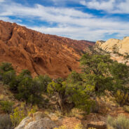
read morePerhaps the best hike in all of Capitol Reef National Park, Upper Muley Twist Canyon is a full-featured Utah adventure that includes narrow canyons, expanses of slickrock, large arches, and dramatic vistas from the top of the incomparable Waterpocket Fold. There are opportunities for side trips to slot canyons and other exciting off-trail experiences, as well as perilous exposure to precarious canyon rims. The canyon was carved over eons through a particularly contrasting section of the Waterpocket Fold where the deep red Wingate Sandstone...
read moreNortheast of the Southern Utah town of Kanab, a surprise slot canyon called Lick Wash is located along Skutumpah Road. It’s 15 miles on twisty, dirty ranch road to get there, but the reward is well worth the adventure. This is the Paria-Escalante region of the national monument, beneath the Pink Cliffs. You will even find pink colored stones and pebbles in the wash. The canyon is narrow at the entry end, widening as you proceed deeper into the wash. This is a nice, easy, short hike to stretch your legs on the way between Southern Utah...
read moreLocated on the very southern tip of the Kaibab Plateau, and the prime vista location for the North Rim of Grand Canyon, Bright Angel Point offers a bird’s-eye view of the meeting of Roaring Springs Canyon and Transept Canyon at the Bright Angel Fault. It is 4/10 mile from Grand Canyon Lodge to the point on a paved trail that offers several overlooks along the way. High altitude (8,148′) and an elevation change of 200 feet warrant extra caution for those with heart or respiratory conditions, so take your time. The trail is high...
read moreThe North Rim of the Grand Canyon doesn’t get nearly the traffic as its more touristy neighbor to the south. For one thing, it is a lot more remote. The North Kaibab Trail is the most difficult of the three trails that dissect the canyon, but it also holds the most varied ecosystem. Somewhat surprisingly, it is forested. With fir and aspen and scrub oak, along with ferns and assorted wildflowers, the North Rim enjoys the color of the seasons. The trail descends through redwall limestone, then the Supai Formation, consisting of mostly...
read moreAngels Landing is a unique fin sandstone monolith that erupts 1,500 feet from the floor of Zion Canyon. The trail to the top is one of the most popular hikes in Zion National Park, certainly the most thrilling. For someone like me with heights and edges phobia and vertigo, it’s a little too much excitement, but there is a compromise. You can still enjoy most of the ascent, then join the West Rim Trail, climbing even higher than Angels Landing without the extreme drop-off business. You’ll steer clear of the crowds that line the...
read moreThe only trail in Zion National Park that is suitable for wheelchairs, allows your pets to join you, and is also bicycle friendly. Pa’rus is from a Paiute word meaning “bubbling, tumbling water.” Both Oak Creek and Pine Creek cross this paved pathway that winds along the Virgin River between the Visitor Center and Canyon Junction. Ideal for start of day or end of day strolls, the sunset in particular dances off the Navajo sandstone formations that surround the river valley. It’s a great way to warm up your legs for the...
read moreMount Baldy surveys Zion Canyon at 6,521 feet elevation, more than 2,100 feet above the valley floor. Jutting out from Mt. Baldy into one of the widest sections of Zion Canyon, Observation Point commands a view of nearly every major attraction, particularly those like Angels Landing and The Organ at Big Bend. Hikers receive a spectacular vista of the lower end of Zion Canyon, with views even beyond the mouth of the canyon. The hike itself is quite steep, with short sections of relief, including the scenic stroll through beautiful Echo Canyon....
read more I am Jeff Clark, founder of Internet Brothers, producer of this blog, and passionate about hiking. I live in Western NC near the Blue Ridge and Great Smoky Mountains. Pisgah and Nantahala National Forests are just out my door, so the content will focus on these areas, but let me know what you would like to see on the site.


Copyright © 2011-2023 Internet Brothers. All Rights Reserved. ISSN 2324-6057
Designed by Elegant Themes | Powered by Wordpress | Logo by Design Aspirations