
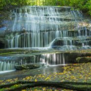
Looking for an easy hike of less than five miles that will take you to several different waterfalls? Yes? Then this just might be the one for you. It starts on the ever popular Cat Gap Trail, passes two falls on Cedar Rock Creek and a whitewater cascade on John Branch before hopping on the Butter Gap Trail to follow Grogan Creek through Picklesimer Fields to the truly...
Learn More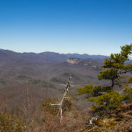
Cedar Rock is one of several granite pluton monoliths found in the Davidson River area of Pisgah National Forest. More difficult to get to than its nearby brethren, Looking Glass and John Rock, Cedar Rock has outstanding long distance views from both the east and west sides of its summit. You will have to work to get there, climbing nearly 1,700 feet from the valley...
Learn More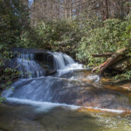
There is a series of waterfalls not far from the Pisgah Center for Wildlife Education and State Fish Hatchery on Forest Road 475. Collectively known as Cedar Rock Falls, they carry Cedar Rock Creek on its plunge down the mountain to Davidson River. Access to these falls and the wetlands beyond is via the Cat Gap Trail, a jumping off connector trail for many of the...
Learn More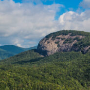
The always popular Cat Gap Loop Trail is a jumping off point for many great hikes within the Davidson River area of Pisgah National Forest. Included among them is the picturesque John Rock, one of the area’s plutons that stand over the recreation area. With views of the Fish Hatchery, Looking Glass Rock, Pilot Mountain and the ridges that run to Graveyard Fields,...
Learn More I am Jeff Clark, founder of Internet Brothers, producer of this blog, and passionate about hiking. I live in Western NC near the Blue Ridge and Great Smoky Mountains. Pisgah and Nantahala National Forests are just out my door, so the content will focus on these areas, but let me know what you would like to see on the site.


Copyright © 2011-2023 Internet Brothers. All Rights Reserved. ISSN 2324-6057
Designed by Elegant Themes | Powered by Wordpress | Logo by Design Aspirations