 his park sits right on the cliff’s edge of the Blue Ridge Escarpment that drops down from the mountains in western North Carolina to the upcountry of South Carolina. The park is more than 3,000 acres of trails, lakes, cabins and camping. Pinnacle Mountain Trail is the most challenging within the park, with a climb […]]]>
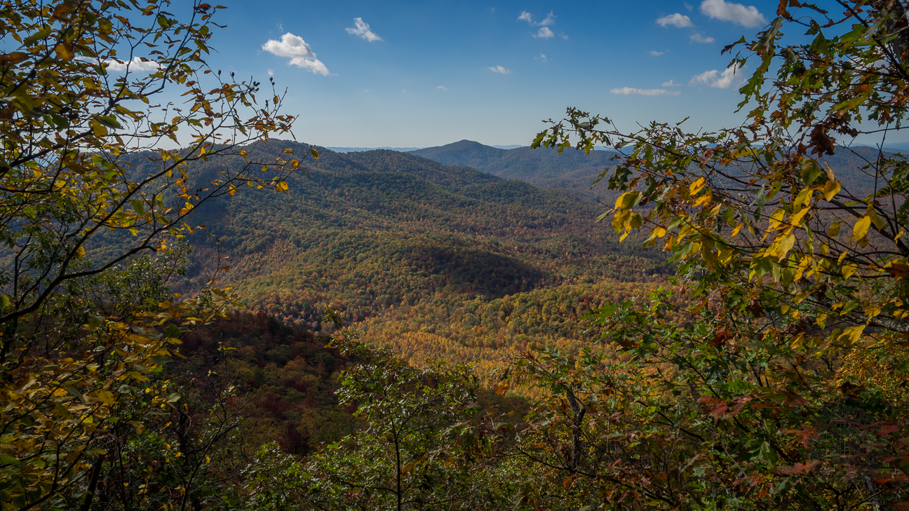
This park sits right on the cliff’s edge of the Blue Ridge Escarpment that drops down from the mountains in western North Carolina to the upcountry of South Carolina. The park is more than 3,000 acres of trails, lakes, cabins and camping. Pinnacle Mountain Trail is the most challenging within the park, with a climb that exceeds 2,300 feet. The lower section follows Carrick Creek, while the upper levels offer fantastic views into the South Carolina Upstate, with massive rock outcroppings along the way. Ken and I hiked Pinnacle Mountain at Table Rock State Park on Monday, December 18, 2017 beginning at 9:30AM and ending about 3:30PM. Our plan was to hike Pinnacle Mountain Trail to the Mill Creek Pass Trail, connect with the Ridge Trail, then take Table Rock Trail to the summit of Table Rock. It didn’t work out that way, and we visited the Pinnacle Mountain summit instead.
Hike Length: 9.4 miles Hike Duration: 6 hours
Hike Rating: Difficult. Particularly the upper portion is extremely strenuous.
Hike Configuration: Lasso Blaze: Yellow, orange, blue
Elevation Change: 2,306 feet Elevation Start: 1,119 feet
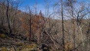
Trail Condition: Some very good. Other sections are still recovering from a 2016 wildfire and 2017’s Hurricane Irma. Trail crews are working very hard to restore the pathways to their former condition.
Starting Point: Parking lot next to north end of Pinnacle Lake.
Trail Traffic: We encountered 12 other hikers, actually kind of a surprise for a December weekday.
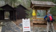
How to Get There: Table Rock State Park is on S.C. Hwy. 11 near the Greenville-Pickens county line. Enter at the west gate, go past the campground and follow the signs to the Nature Center. Park in the lot across from the Nature Center and cross the road. The trail is behind the Nature Center. Please fill out the hiker registration form at the kiosk. It’s for your safety. There is a $5 day use fee.
When we arrived at the Table Rock State Park Visitor Center on Lake Oolenoy we learned that a change of plans was in the cards. Instead of heading up Table Rock via the Pinnacle Mountain Trail and Mill Creek Pass, we would instead hike to the summit of Pinnacle Mountain. Why? 2016 brought a devastating wildfire to the forest of Table Rock and 2017 saw Hurricane Irma ravage the area, blowing down trees and eroding trails. Not to worry. This would still be an enjoyable hike. We also learned that over the years since our last visit to Table Rock State Park, they had raised the day use fee from $2 per person to $5. Still a bargain.
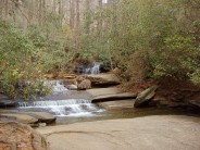
The lower part of this hike follows Carrick Creek past a series of small waterfalls, over wooden footbridges, and along smooth creek bedrock. It shares the first quarter mile with the Table Rock Trail, one that we had hiked way back in 2011. At the split we turned left onto yellow-blazed Pinnacle Mountain Trail, while Table Rock Trail goes to the right.
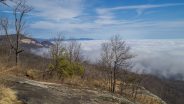
We happened to arrive on a very foggy morning. The forest was actually kind of eery. However, a pair of hikers coming down the mountain from an overnight camp told us there was good news ahead. We would eventually climb above the cloud inversion, offering a masterpiece view of the low valley fog.
The next two and a half miles are gently uphill, passing through deciduous forest and groves of mountain laurel and rhododendron. You continue to follow Carrick Creek for a mile or more, much of it rubbed bare and smooth over thousands of years draining Pinnacle Mountain. You could almost slide on your behind along the path of the creek like a water park, but don’t. They wouldn’t like that.
The higher you get, the rockier the terrain. Car sized boulders and fins appear in the woods, crumbling eons ago from the escarpment high above. Just past the 2.5 mile marker you reach The Mill Creek Falls spur trail. It was our intention to take the 0.4 mile sidetrack to observe the waterfall. However, it is still closed thanks to the thoughtlessness of Hurricane Irma.
So on we pushed, soon passing the southern end of the Mill Creek Pass Trail, one that we would use for our return after visiting Pinnacle Mountain. The rocks are house size now, and we began to enter the wildfire zone. It was really hard to tell how much the ecology has recovered in one short year because we were there in winter. There was no green to be seen. There are, however, still many, many burn marks.
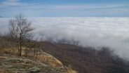
The trail really begins climbing in earnest now, becoming increasingly steeper the higher you go. This makes it all the more amazing how the wildfire burned this steepest part of the mountain. We had also now cleared the fog layer, and were looking down upon it. Nearly 400 feet above the Pass junction, you reach the remarkable Bald Rock.
There are two levels to this massive cliff face, each offering a unique view of the South Carolina Upstate. The first level is a little more rounded, with a less scary edge, but the upper level has a definitive precipice. You don’t want to get too close because it is a very long way down. The vista to the south was limited because of the sea of clouds below us, but there is a magnificent view of the Table Rock pluton off to the east.

Don’t get too close to the Bald Rock edge. Believe me, the bottom is not as soft as those clouds look.
There was a nice couple sitting on Bald Rock, enjoying lunch. We chatted for a bit and learned this was to be their turning around point. Based on what I learned later, I kinda wish I’d made the same decision.
From Bald Rock, the trail climbs another 625 feet to the summit of Pinnacle Mountain in just a half mile, or less. That is steep folks… and I’m not afraid to tell you that it took everything I had to make it to the top. I’m not as strong a hiker as I was five years ago (I am older after all), but I can still hold my own. Believe me when I tell you that this half mile stretch is strenuous.
About half way there you reach the junction with the famous Foothills Trail. If you are ever interested in a multi-day trek in this neck of the woods, there is a lot to behold along the Foothills, including the nearby Sassafras Mountain.
It’s still another 340 feet up to the summit, the steepest part yet. It doesn’t get any easier. As you’ll see from the picture below that I took of the summit sign, I did make it, but I was a wreck when I reached the top. The good news is the nice logs at the summit that make perfect seats for a rest, and a lunch break.
Ken, as he always does, still seemed fresh from the climb, but he did admit to me that even he was tired. We stayed for about 20 minutes, eating lunch, and catching our breath. There isn’t really much to see on the summit, unfortunately. There are no cool views or historic artifacts, just the self-knowledge that you accomplished the feat.
Here, the Pinnacle Mountain Trail meets the orange-blazed Ridge Trail. You can take the Ridge Trail all the way nearly two miles to its meeting with the Table Rock Trail, but our plan was just to descend to the upper junction of the Mill Creek Pass Trail. As you would expect, the first quarter mile going down is very steep, just like the ascent. We ran into more evidence of the 2016 wildfire along the way.
It’s ¾ mile to the bypass, dropping a total of 550 feet. Then, the blue-blazed Pass Trail is another ¾ mile, and drops another 400 feet. Hard on the knees and hips. Look for lots and lots of mountain laurel along the way. This stretch of trail is probably quite beautiful with pink and white flowers in May.
Once back on the Pinnacle Mountain Trail, it’s then a three mile trudge back to the trailhead, terrain already covered on the way up. It was more clear now, as the fog layer had finally burned off, and the air temp had warmed nicely. We encountered a half dozen more hikers getting a late start on their way up, likely overnighters.
In summary, this hike is hard, but that doesn’t make it a bad experience. Bald Rock, for example, is by itself well worth the effort. The views are stupendous. Perhaps just consider an up and back to there. If you are a really gung-ho super hiker, then go for the entire loop to Pinnacle Mountain, on to Panther Gap and Governor’s Rock, and then up to the summit of Table Rock, a total of about 12 miles with two major ascents. Y’know, I’ve only visited Table Rock in the winter so far. I think I need to plan a spring excursion.
I'd like to pass along a well deserved pat on the back for all the employees and volunteers of the SC Parks Dept. who have been working on repairs to the Table Rock trail system since the devastating wildfire and hurricane. The crews have done remarkable work restoring access to the trails. There's still a lot of work to do, but they earn huge kudos from me.


]]>
Join Conserving Carolina, formerly the Pacolet Area Conservancy (PAC) and Carolina Mountain Land Conservancy (CMLC), for five Friday hikes offered to the public, free of charge, this fall.
Conserving Carolina invites the community to enjoy the work that many conservation organizations have done for the preservation of areas of natural resources and take in the beauty of autumn.
Starting September 22, the first trek will head to Caesar’s Head State Park, part of the Mountain Bridge Wilderness Area, for an approximately 6.7-mile, easy, out and back hike. This trail will take hikers through a hardwood forest to a suspension bridge over Matthews Creek and at the precipice of Raven Cliff Falls. After the hike, participants are invited to visit the overlook at Caesar’s Head State Park, an official Hawk Watch site, to search the skies for migrating raptors. Each year, thousands of raptors, especially Broad-winged Hawks, migrate over this site along the Blue Ridge Escarpment, using thermal currents formed by sun on the rock, to gain altitude and glide for miles over the Piedmont, expending very little energy.
South Carolina hikers interested in attending on September 22nd are asked to meet at the Spinx in Gowensville, SC (at the intersection of Hwy 14 and Hwy 11) at 8:30 a.m. to check in and start the approximately 45-minute drive to the Raven Cliff Falls parking area at Caesar’s Head State Park. North Carolina hikers plan to be at the Raven Cliff Falls parking area by 9:30 a.m. Hikers should be prepared to return to the area in the mid-afternoon.
On October 6, the hike will take place at Buffalo Creek Park in Hickory Nut Gorge. The trail at Buffalo Creek Park is on land owned by the Town of Lake Lure and protected by Conserving Carolina. It was completed in 2014 and is the first phase of a trail system that will offer over 13-miles of multi-use trails in Hickory Nut Gorge. This is a 4.7-mile, moderate, loop hike that ascends Weed Patch Mountain with a gain of 500 feet in elevation. It then passes through a large boulder field offering views of the surrounding mountains and Lake Lure, then descends the mountain back to the trailhead.

What would you expect to find in Hickory Nut Gorge?
South Carolina hikers interested in attending the October 6th hike are asked to meet in the parking area west of Home Trust Bank, 651 W Mills St, Columbus, NC 28722 at 8:30 a.m. to check in and start the approximately 35-minute drive to Buffalo Creek Park parking area. North Carolina hikers meet the group at the entrance to Buffalo Creek Park by 9:30 a.m.
On October 20, the 3.8-mile, moderate, out and back hike will take place along a portion of the Mountains to Sea Trail to the ruins of Rattlesnake Lodge, a 1900’s summer estate, offering a beautiful overlook view.
South Carolina hikers interested in attending the October 20th hike are asked to meet in the parking area west of Home Trust Bank, 651 W Mills St, Columbus, NC 28722 at 8:30 a.m. to check in and start the approximately 1 hour drive to the parking area off Ox Creek Road at Bull Gap. North Carolina hikers join the group at the trailhead by 9:30 a.m.
On November 3, hikers head to Pisgah National Forest for a 6-mile, moderate, out and back hike starting from the former site of George Vanderbilt’s Buck Spring hunting lodge near Mt. Pisgah. The hike crosses the summit of Little Bald Mountain before dropping down to Pilot Rock, offering beautiful mountain views.
Expect stunning vistas of the Cradle of Forestry and beyond from Pilot Rock.
South Carolina hikers interested in attending the November 3rd hike are asked to meet in the parking area west of Home Trust Bank, 651 W Mills St, Columbus, NC 28722 at 8:30 a.m. to check in and start the approximately 1 hour drive to the parking area near the former site of George Vanderbilt’s Buck Spring hunting lodge near Mt. Pisgah. North Carolina hikers join the group at the Buck Spring Gap Overlook, mile 407.7 on the Blue Ridge Parkway at 9:30 a.m. You may have to wait a bit for the South Carolina participants to arrive.
Finally, on November 17, the group will head to Pinnacle Mountain (Long Ridge) in Table Rock State Park. Pinnacle Mountain is the tallest mountain contained entirely within the state of South Carolina (SC’s highest point, Sassafras Mountain, is partially in North Carolina). The 5.5-mile, moderate hike will traverse areas affected by fires in the fall of 2016 and lead hikers to a granitic bald where, in the late 1990s, more than 600 prehistoric petroglyphs were discovered. The petroglyphs, believed to be created by the Hopewell culture, pre-date the Cherokees and are believed to be between 1,500 and 3,500 years old.
South Carolina hikers interested in attending the November 17th hike are asked to meet at the Spinx in Gowensville, SC (at the intersection of Hwy 14 and Hwy 11) at 8:30 a.m. to check in and start the approximately 40-minute drive to the parking area at Sliding Rock road. North Carolina hikers meet at the trailhead in Table Rock State Park by 9:30 a.m. Hikers should be prepared to return to the area in the mid-afternoon.
For your safety, do not attempt any hike beyond your ability and experience. Hikers should wear appropriate clothing and footwear; bring a bag lunch and/or snack and plenty of water. Please be sure to bring any personal medication that you may require.
In case of inclement weather, please contact the Southeast (Polk County) office by 8:15 on the day of the hike and/or the Conserving Carolina Facebook page to see if the hike will take place.
If you are interested in attending Conserving Carolina’s fall hikes and would like more information, please call the Southeast (Polk County) office at 828-859-5060 or e-mail Pam Torlina at, [email protected]. You can also find information on Conserving Carolina’s website, www.conservingcarolina.org, and on Conserving Carolina’s Facebook page.
Conserving Carolina is dedicated to protecting and stewarding land and water resources vital to our natural heritage and quality of life and to fostering appreciation and understanding of the natural world.
]]>
 his park sits right on the cliff’s edge of the Blue Ridge Escarpment that drops down from the mountains in western North Carolina to the upcountry of South Carolina. The park is more than 3,000 acres of trails, lakes, cabins and camping. Table Rock State Park is located 12 miles north of Pickens, SC. This […]]]>
This park sits right on the cliff’s edge of the Blue Ridge Escarpment that drops down from the mountains in western North Carolina to the upcountry of South Carolina. The park is more than 3,000 acres of trails, lakes, cabins and camping. Table Rock State Park is located 12 miles north of Pickens, SC. This hike occurred on February 2, 2011 beginning at 9:30AM and ending at 2:30PM. Three of us set out with a goal of climbing the nearly 2000 feet to the summit of Table Rock Mountain on the Table Rock Trail. Near the 3124′ summit there are views of Table Rock Reservoir and Caesars Head, Slicking Falls, as well as much of the South Carolina upstate. The trail returns the same way.
Hike Length: 7.2 miles Hike Duration: 5 hours
Hike Rating: Difficult Blaze: Red
Elevation Gain: 1964 feet Hike Configuration: Up and back
Trail Condition: mostly good, some roots Starting Point: Nature Center
Trail Traffic: We did not see any other hikers on this trail the entire duration.
How to Get There: Table Rock State Park is on S.C. Hwy. 11 near the Greenville-Pickens county line. Enter at the west gate, go past the campground and follow the signs to the Nature Center. Park in the lot across from the Nature Center and cross the road. The trail is behind the Nature Center. Please fill out the hiker registration form at the kiosk. It’s for your safety.
View Table Rock Trail, Table Rock State Park, SC in a larger map
Important South Carolina state parks require a day use fee. Before you go to the trailhead, be sure to stop by the park Visitor Center on Oolenoy Lake and pay your $2.00 fee. They will give you a placard to hang on the rearview mirror of your car. This hike starts at the Nature Center at the end of W. Gate Road. The first 1/2 mile has numerous nicely maintained stone and log steps as it follows Carrick & Green Creeks on a steady steep climb. There are several 5-10 foot waterfalls that help set the mood for this beautiful creek-side stroll through the hardwood forest. We were very impressed with the trail maintenance, indicating the $2.00 fee is being well spent.
For the next mile the trail climbs steeply and leaves Green Creek. We passed by a large boulder field with stones as big as a house. The woods are very lovely and quiet through this stretch; good thing, because it took my mind off my burning lungs and legs. At 2400′ elevation we reached the halfway point; the Civilian Conservation Corps Trail-side Shelter. The view is very nice here of Pinnacle Lake and the SC upcountry. It’s a good spot for pictures. The next milestone came at 2.1 miles when we reached Panther Gap. Here the trail forks with access to the left to Ridge Trail that goes 1.9 miles to Pinnacle summit. We took the right fork to continue our climb up Table Rock Mountain. The next 1/2 mile is a very steep slog through more granite boulders.
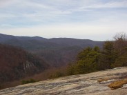
 At the 2.6 miles mark we arrived at Governor’s Rock, a giant granite outcrop. There are carved steps in the granite to help ascend this extremely steep section. Governor’s Rock sits at 2800′ elevation along the trail. From here we could see Pinnacle Mountain, Hickory Nut Mountain, and Sassafras Mountain, the highest point in South Carolina. This is another great spot for picture taking. Like many of the large granite mountain tops in the Blue Ridge, there are multi-colored mosses that grow and cling to Governor’s Rock no matter the season.
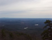
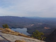
 It’s another 300 feet up and .6 mile to the summit of Table Rock Mountain, but this isn’t the end of the trail. There is a sign on the trail to designate the summit, but now we started heading down the other side to the overlooks. There are two outstanding view points. The first is 700 feet past the summit, looking across the gorge to the 400 foot cascade of Slicking Falls. We stopped for lunch at this point and watched the waterfall for 20 minutes. The trail ends 1/3 mile past the summit with a stunning view across Table Rock Reservoir to Caesars Head State Park on the other side. The photo at the top of this post is the view from the end of the trail. Be extra careful near the drop-offs. These overlooks are on sheer cliffs. It is a long way down!
The return trip was back the same way we came. We had the option of taking the Ridge Trail fork to Pinnacle Mountain summit, but we were already a bit tired. The extra 3.8 miles would have been a bit too much. We completed the full 7.2 miles up and back in right at five hours. It can be done in less, but we stopped for lunch and breaks. This is a pretty strenuous humper of a hike that tested our lungs and legs. On this day, we won.


]]>