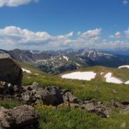
Perhaps one of the reasons you head for the Colorado Rockies is the wealth of national parks and monuments. Maybe you enjoy the amazing increase in distance from high altitude golf. If you are a hiker, perhaps you welcome the opportunity to climb one of Colorado’s famous fourteeners. If that’s the case then this hike up Clear Creek County’s 13,234 foot Mt. Sniktau is an excellent warmup. The entire hike occurs above 12,000 feet. You will find out quickly if your lungs and legs are acclimated to the thin and dry air that...
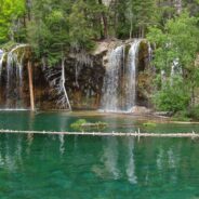
read moreI first visited Hanging Lake in 1982. I heard this summer that the federal government had designated the site a National Natural Landmark, so it piqued my curiosity to take a look again. Glenwood Canyon is a rugged and remarkably scenic place with tall red sandstone cliffs rising 1300 feet on both sides of the Colorado River. The trail up the canyon to the lake follows Dead Horse Creek. Legend has it a gold miner was in the canyon searching for a new stake when he came upon a dead horse at a gulch where a creek fed the Colorado. He climbed...
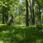
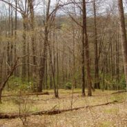
read moreFlat Laurel Creek is in the area just north of the Pisgah Ridge and in between the Shining Rock and Middle Prong Wildernesses. It drains from Sam Knob and Little Sam Knob and runs to the West Fork of the Pigeon River. The trail that bears its name starts at the headwater and travels 3.7 miles around the west side of Little Sam until it meets Hwy. 215 and joins the Mountains to the Sea Trail. Most of the trail is an old railroad grade that was used in the early to mid 20th century. This hike occurred on Thursday, August 11, 2011 from 9:30am to...
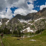
read moreMissouri Lakes Basin in the Holy Cross Wilderness is one of the most beautiful areas in Colorado for hiking and camping that I have experienced. It is an area of lakes and streams filled with trout and large glacial boulders, surrounded by lush forest and tundra, and the gnarly cliffs of the Sawatch Range in the Holy Cross Wilderness. There is some of just about every type of scenery for all hikers to enjoy. The trailhead starts at 10,050 feet and climbs gradually to nearly 12,000 in four miles. This is a popular area as you can imagine, so...
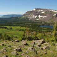
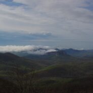
read moreFlat Tops Wilderness is the second largest U.S. Wilderness Area in Colorado. Located near the towns of Yampa and Steamboat Springs, it is 235,214 acres, with 38,870 acres in Routt National Forest and 196,344 acres in White River National Forest. The area is named for a series of flat top mountains that dominate the landscape. This is sub-alpine and alpine terrain with beautiful mountain ponds and lakes, rich evergreen forest, grassy marshes, and craggy tundra. The elevation ranges from 7,600 to 13,000 feet. There are 160 miles of trails in...
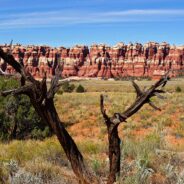
read moreCanyonlands National Park is in the southeastern corner of Utah, near Arches and Dead Horse Point. It is divided into four distinct districts: Island in the Sky, Needles, Maze, and Horseshoe Canyon. The Needles District forms the southeast corner of Canyonlands and was named for the colorful spires of Cedar Mesa Sandstone that dominate the area. The district’s extensive trail system provides many opportunities for long day hikes and overnight trips. Chesler Park is a scenic expanse of desert grasses and shrubs surrounded by colorful sandstone...
read morePerhaps it seems I’ve been spending quite a bit of time hiking in the eastern section of Shining Rock Wilderness in recent months. I can’t help myself. The terrain is wild, the forests ever-changing, the views exhilarating, and the exercise invigorating. The elevation changes dramatically — more than two thousand feet. The air is cool and refreshing even during the summer. It’s enjoyable to follow the wildflower progression from bluets and trillium to catawba rhododendron, to mountain laurel and flame azalea, then...
read moreGorges State Park was developed as a unique partnership of industry, the environmental community and the state of North Carolina. In 1999 more than 10,000 acres of the Jocassee Gorges in Transylvania County were purchased by the state from Duke Energy Corporation. The transaction created a 2,900-acre Gameland managed by the N.C. Wildlife Resources Commission, as well as nearly 7,500 acres that has been designated as Gorges State Park. Because the park is so new, it is still in a planning and development phase. The roads and infrastructure...
read moreThis is an extension of the trail report about the Panthertown Trail System in Nantahala National Forest from a previous post. When we explored Panthertown last November, we knew very little about it and kind of fumbled our way along the myriad of trails. Since, we have studied the trail system map and had a plan that included going to the top of Big Green Mountain, a sight we missed before. This hike occurred on Friday, June 24, 2011 beginning at 10:00AM and ending about 2:45PM. Our plan was to start at the Cold Mountain Gap entrance and...
read moreLooking at a trail map or topographic map, the area of this hike within Shining Rock Wilderness can be somewhat confusing. There is the Greasy Cove Prong, a creek that runs off of the Grassy Cove Ridge. The trail is called Greasy Cove, but it starts/ends at Grassy Cove Top. I think the guys who named the area may have had a touch too much huckleberry wine. Regardless of the befuddling names, the hike has a bit of everything for hiking enthusiasts. There are sections of hardwood forest, a couple creek and river crossings, a steady climb...
read moreThis a continuation beyond the hike described in the Black Balsam Knob and Tennent Mountain trail report. The Art Loeb Trail continues down the north side of Tennent Mountain to Grassy Cove. There it meets the Ivestor Gap Trail for a lengthy hike into Shining Rock Wilderness. The area was named by the Cherokee for the large deposits of quartz found along what has become known as the Shining Rock Ledge. The Ivestor Gap Trail avoids having to cross up and over Grassy Cove Top, Flower Gap, and Flower Knob. Ivestor Gap reattaches with Art Loeb at...
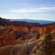
read moreBryce Canyon National Park is in the southwestern corner of Utah, near Zion and Cedar Breaks. Most of the park is above 8000 feet elevation, so the air is clear and the views long. Bryce Canyon is famous for its odd, fanciful geologic formations known as hoodoos and the myriad of color found in the sandstone. The Fairyland Loop Trail is one of the best kept secrets about Bryce Canyon. Located at the far northern tip of the park, most of the tourists blow right past Fairyland on their quest for car accessible Bryce overlooks. So Fairyland is a...
read moreI will probably always be comparing Linville Gorge west rim trails that go down to the river to the Babel Tower Trail because that is the first one I hiked. Conley Cove is not quite as difficult because, unlike the straight-line trail that is Babel Tower, Conley Cove is a long continuous series of switchbacks. But, it is still a stern test of strength and stamina. This popular area has the unique distinction of having both a vista trail and a gorge trail. Before heading down, down, down into the gorge, the Rock Jock Trail enables hikers to...
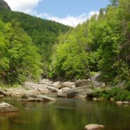
read moreSitting right along the Tennessee/North Carolina border in the far northeast corner of Great Smoky Mountains National Park is an enjoyable section of forest and creek side trails that navigate the Big Creek area of the park. The Appalachian Trail goes through the area, as does the Benton MacKaye Trail, named for the planner of the AT. There are mountains in the region as well. Mt. Cammerer and Mt. Sterling are popular hikes with splendid views, but on this day my brother and I wanted to do some creek hiking. This hike occurred on May 18, 2011...
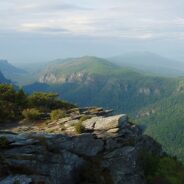
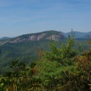
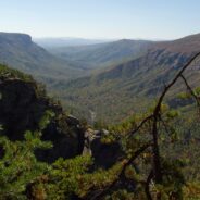
read moreLinville Gorge runs north to south and has two entirely different rims. Trails on the west rim start on top and go down into the gorge to Linville River. Trails on the east rim go to a series of mountains that offer views into the full length of the gorge, and of the North Carolina Piedmont to the east and the Black Mountains to the west. There are a couple downward trails on the east rim, but the biggest attraction is the mountains. It is fully 2000 feet from these mountaintops to the Linville River below. Hawksbill and Tablerock Mountains...
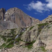
read moreElevations in Rocky Mountain National Park in northeast Colorado range from 8,000 feet in the grassy wetlands of the montane, to well above 14,000 feet in its alpine regions. The tallest mountain in the park is Longs Peak at 14,259′. Sitting in a circular basin 2400′ below Longs Peak is Chasm Lake, a mirror of water surrounded by the rocky alpine. More than half the trail to Chasm Lake is above treeline in the alpine tundra, so the views are long and the vistas grand. That also means the hike to Chasm Lake is exposed, so...
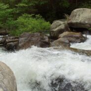
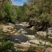
read moreGreen River Game Lands is a 10,000 acre tract in Henderson and Polk Counties owned by the state of North Carolina and maintained by ECO, the Environmental and Conservation Organization, a non-profit group in Hendersonville, NC. There are 16 miles of hiking trails available within the boundary of the Game Lands. The Green River Narrows is a haven for extreme kayaking, known as one of the best runs in all of the Southeast. There is a kayak race held there in November every year. Hikers can enjoy this wild and crazy stretch as well, where the...
read moreExplorer William Linville and his sons were scalped by Indians in 1766 in what would eventually become known as Linville Gorge. I do believe I’d be fine with going through life not having anything named for me. The Linville Gorge Wilderness in Burke County, NC was one of the first protected areas in the country under the Wilderness Act of 1964. I’ve enjoyed this rugged country a number of times now. The west rim of the gorge is known for its steep descents down to Linville River, while the east rim is a series of spectacular...
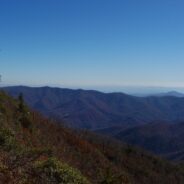
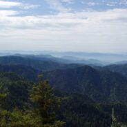
read moreFrequently. That is how many times I have done this hike. So many, I’ve lost count. I love the western North Carolina high country, and this area along the Blue Ridge Parkway known as Black Balsam has nearly a dozen peaks over 5,800 feet elevation, with Black Balsam Knob being the highest at 6,214. This area has some of the highest hiking on the Parkway. Many of these mountains are what are called balds, because they do not have trees on their tops, not because they are above treeline. There has been a series of fires in this area, the...
read moreCoontree is a popular picnic area for familes along Davidson River in Pisgah National Forest, NC. What most of them probably don’t know though, is that there is a nice hiking trail just across Hwy. 276 from the parking area. It is very easy to get to, as it is only five miles from the crossroads in Brevard, NC. The trail itself is a loop with a connector at the top to the Bennett Gap Trail where there are terrific views of the surrounding mountains and plutons. The western half of the loop follows Coontree Creek and crosses it several...
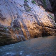
read moreThis hike has a reputation for being one of the best in the country, for good reason. The scenery, the environment, the trail (or lack thereof) are all unique and awe inspiring. You are actually hiking in the Virgin River through what is known as The Narrows in Zion Canyon. Steep sandstone cliffs rise a thousand feet or more on both sides of the river. The colors in the rock are stimulating. As the limited light strikes the river and the sandstone, glows can range from hues of gold and copper, to pink, orange and red. The vegetation that...
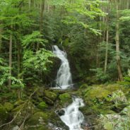
read moreHidden deep within the Mills River area of Pisgah National Forest, the Pilot Cove/Slate Rock Creek loop trail is primarily a water feature hike. There are two notable waterfalls and several cascades on Slate Rock Creek, and views of Slate Rock through the trees. We encountered several creek crossings (some wading, some with log bridges), and a relatively young forest. This hike occurred on April 14, 2011 beginning at 10:45AM and ending about 2:15PM. The plan was to take the Pilot Cove Trail through Pilot Cove then up on the rim overlooking...
read moreCold Mountain gained national attention following the publishing of Charles Frazier’s Civil War era novel in 1997. Western NC hiking enthusiasts have known of its appeal for much longer. Cold Mountain is a real mountain that stretches 6030′ and is located in the Shining Rock Wilderness and Pisgah National Forest in North Carolina. You can reach the spur trail to the summit on the Art Loeb Trail; section 3 from the south, or section 4 from the west. The trail was named for a member of the Carolina Mountain Club who devoted much of...
read moreMeanderthals took a little break last week as I attended The Masters at Augusta National Golf Club in Georgia. There are a handful of athletic events that qualify as once-in-a-lifetime opportunities. Some that come to mind are The Olympics, The World Cup, The Superbowl, The NCAA Final Four. In my estimation The Masters is right there with that group. It may be one of the hardest tickets to obtain anywhere. The golf course itself is in a league of its own with its lush fairways and manicured greens, its towering pines and flowering azalea. The...
read moreMost people think of Skyline Drive, or the mountains that overlook Shenandoah Valley when they imagine Shenandoah National Park in Virginia. But my favorite hike during a visit in early autumn was the Cedar Run, Whiteoak Circuit that starts at milepost 45.6 on the SD. It’s a brute of a hike, but well worth the effort exerted for the combinations of creeks and streams, waterfalls, deep forest and wildlife. This is one where you might want to consider your physical condition. No matter which direction you go, there is going to be a very...
read moreOne of the enduring pleasures in the Tennessee portion of the Great Smoky Mountains National Park is scaling the 6,593 feet of beauty that is Mt. LeConte. It isn’t quite the highest mountain in the park, but it is by far the tallest hike from its base. The summit is so popular, there are five distinct trails to the top, varying in distance and difficulty. My favorite is the Alum Cave Trail. It is the shortest, at five miles to the summit, but as a result it is also the steepest and most difficult. At the top are cabins known as LeConte...
read moreFormal protection of the Linville Gorge began in 1952, when the land was purchased with funds donated by John D. Rockefeller, Jr. When the Wilderness Act was approved by Congress and signed into law by President Johnson in 1964, the Linville Gorge Wilderness became one of the first formally designated Wilderness areas of the new National Wilderness Preservation System. Wonderful news for future generations, as this wilderness that covers more than 12,000 acres will remain in the same pristine condition for centuries to come. The area is...
read morePanthertown Valley lies in Nantahala National Forest near Cashiers and Lake Toxaway, North Carolina. The Forest Service, along with the Friends of Panthertown, have created a trail system in combination with old logging roads that lead to waterfalls, cliffs, bogs, deep forest and spectacular overlooks of the surrounding valley. Panthertown has been designated a Blue Ridge National Heritage Area. This hike occurred on November 18, 2010 beginning at 9:00AM and ending about 3:00PM. We did not have a particular hike itinerary because only one of...
read moreThe Middle Prong Wilderness is west of North Carolina Hwy. 215 and north of the Blue Ridge Parkway. It is named after the Middle Prong of the Little Pigeon River that runs through the heart of the wilderness. This is remote territory in the high country near 6000 feet. Prepare yourself for heavy breathing — from exertion, and from natural beauty. Buckeye Gap Trail takes you to Middle Prong, then Haywood Gap Trail follows the river back up the drainage. This hike occurred on November 5, 2010 beginning at 8:00AM and ending about 2:00PM....
read moreBetween North Carolina Scenic Hwy. 276 and the Pisgah Inn is Fryingpan Mountain, one of a series of mountains along the north side of the Blue Ridge Parkway that help form the Pisgah Ridge. It sits at mile 410 on the parkway. A unique feature of Fryingpan is the 1940s era fire tower that affords spectacular views of the surrounding Blue Ridge. The tower is on the National Register of Historic Places. This hike occurred on February 11, 2011 beginning at 10:00AM and ending about 2:00PM. Our goal on this day was to start at the Mt. Pisgah Trail,...
read more I am Jeff Clark, founder of Internet Brothers, producer of this blog, and passionate about hiking. I live in Western NC near the Blue Ridge and Great Smoky Mountains. Pisgah and Nantahala National Forests are just out my door, so the content will focus on these areas, but let me know what you would like to see on the site.


Copyright © 2011-2023 Internet Brothers. All Rights Reserved. ISSN 2324-6057
Designed by Elegant Themes | Powered by Wordpress | Logo by Design Aspirations