
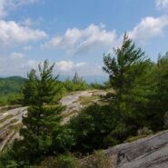
This is an extension of the trail report about the Panthertown Trail System in Nantahala National Forest from a previous post. When we explored Panthertown last November, we knew very little about it and kind of fumbled our way along the myriad of trails. Since, we have studied the trail system map and had a plan that included going to the top of Big Green Mountain, a...
Learn More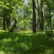
Looking at a trail map or topographic map, the area of this hike within Shining Rock Wilderness can be somewhat confusing. There is the Greasy Cove Prong, a creek that runs off of the Grassy Cove Ridge. The trail is called Greasy Cove, but it starts/ends at Grassy Cove Top. I think the guys who named the area may have had a touch too much huckleberry wine. Regardless of...
Learn More
This a continuation beyond the hike described in the Black Balsam Knob and Tennent Mountain trail report. The Art Loeb Trail continues down the north side of Tennent Mountain to Grassy Cove. There it meets the Ivestor Gap Trail for a lengthy hike into Shining Rock Wilderness. The area was named by the Cherokee for the large deposits of quartz found along what has become...
Learn More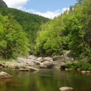
I will probably always be comparing Linville Gorge west rim trails that go down to the river to the Babel Tower Trail because that is the first one I hiked. Conley Cove is not quite as difficult because, unlike the straight-line trail that is Babel Tower, Conley Cove is a long continuous series of switchbacks. But, it is still a stern test of strength and stamina. This...
Learn More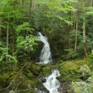
Sitting right along the Tennessee/North Carolina border in the far northeast corner of Great Smoky Mountains National Park is an enjoyable section of forest and creek side trails that navigate the Big Creek area of the park. The Appalachian Trail goes through the area, as does the Benton MacKaye Trail, named for the planner of the AT. There are mountains in the region as...
Learn More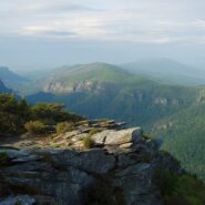
Linville Gorge runs north to south and has two entirely different rims. Trails on the west rim start on top and go down into the gorge to Linville River. Trails on the east rim go to a series of mountains that offer views into the full length of the gorge, and of the North Carolina Piedmont to the east and the Black Mountains to the west. There are a couple downward...
Learn More
Explorer William Linville and his sons were scalped by Indians in 1766 in what would eventually become known as Linville Gorge. I do believe I’d be fine with going through life not having anything named for me. The Linville Gorge Wilderness in Burke County, NC was one of the first protected areas in the country under the Wilderness Act of 1964. I’ve enjoyed...
Learn More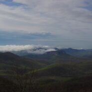
Frequently. That is how many times I have done this hike. So many, I’ve lost count. I love the western North Carolina high country, and this area along the Blue Ridge Parkway known as Black Balsam has nearly a dozen peaks over 5,800 feet elevation, with Black Balsam Knob being the highest at 6,214. This area has some of the highest hiking on the Parkway. Many of...
Learn More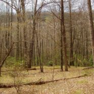
Hidden deep within the Mills River area of Pisgah National Forest, the Pilot Cove/Slate Rock Creek loop trail is primarily a water feature hike. There are two notable waterfalls and several cascades on Slate Rock Creek, and views of Slate Rock through the trees. We encountered several creek crossings (some wading, some with log bridges), and a relatively young forest....
Learn More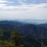
One of the enduring pleasures in the Tennessee portion of the Great Smoky Mountains National Park is scaling the 6,593 feet of beauty that is Mt. LeConte. It isn’t quite the highest mountain in the park, but it is by far the tallest hike from its base. The summit is so popular, there are five distinct trails to the top, varying in distance and difficulty. My...
Learn More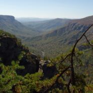
Formal protection of the Linville Gorge began in 1952, when the land was purchased with funds donated by John D. Rockefeller, Jr. When the Wilderness Act was approved by Congress and signed into law by President Johnson in 1964, the Linville Gorge Wilderness became one of the first formally designated Wilderness areas of the new National Wilderness Preservation System....
Learn More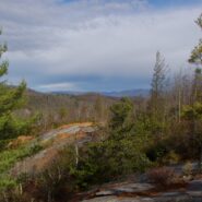
Panthertown Valley lies in Nantahala National Forest near Cashiers and Lake Toxaway, North Carolina. The Forest Service, along with the Friends of Panthertown, have created a trail system in combination with old logging roads that lead to waterfalls, cliffs, bogs, deep forest and spectacular overlooks of the surrounding valley. Panthertown has been designated a Blue...
Learn More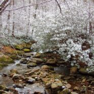
The Middle Prong Wilderness is west of North Carolina Hwy. 215 and north of the Blue Ridge Parkway. It is named after the Middle Prong of the Little Pigeon River that runs through the heart of the wilderness. This is remote territory in the high country near 6000 feet. Prepare yourself for heavy breathing — from exertion, and from natural beauty. Buckeye Gap Trail...
Learn More
Between North Carolina Scenic Hwy. 276 and the Pisgah Inn is Fryingpan Mountain, one of a series of mountains along the north side of the Blue Ridge Parkway that help form the Pisgah Ridge. It sits at mile 410 on the parkway. A unique feature of Fryingpan is the 1940s era fire tower that affords spectacular views of the surrounding Blue Ridge. The tower is on the...
Learn More I am Jeff Clark, founder of Internet Brothers, producer of this blog, and passionate about hiking. I live in Western NC near the Blue Ridge and Great Smoky Mountains. Pisgah and Nantahala National Forests are just out my door, so the content will focus on these areas, but let me know what you would like to see on the site.


Copyright © 2011-2023 Internet Brothers. All Rights Reserved. ISSN 2324-6057
Designed by Elegant Themes | Powered by Wordpress | Logo by Design Aspirations