
Blue Ridge Parkway officials announce the closure of a small section of motor road between existing gates at Milepost 420.3 near US Forest Service Road 816 (Black Balsam Road) and Milepost 423.3 at NC Highway 215. Both lanes of the motor road in that section will be closed to all visitors beginning November 3, 2014 through May 2015. During this closure, Devil’s...
Learn MorePicture the Blue Ridge Parkway as a crooked spine running through the Appalachian Mountains. Government stewardship of public lands is splashed across the map in confusing variety – a national park at either end, national forests, historic sites, monuments and state parks along its 469 miles. The road snakes through some of the most glorious fall color in North America...
Learn More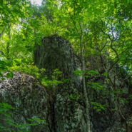
Another foray into the Black Mountains led us to summits with names like Point Misery, Little Butt and Big Butt. The Big Butt Trail takes off from Balsam Gap on the Blue Ridge Parkway along Brush Fence Ridge, roller-coastering across several peaks and gaps. The forest is filled with floral and fungal oddities, and old-growth spruce and pine that protect the ridge like...
Learn More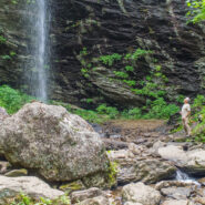
Sometimes you have to work for the reward at the end of the trail. Hiking from Craggy Gardens to Douglas Falls is a prime example. You will descend 1,350 feet from the Blue Ridge Parkway to this 70-foot waterfall through a luscious forest of birch, maple, and beech, even enjoying old growth hemlock along the way. Expect a rough hike, as the terrain is very rugged in the...
Learn MoreEarly in the 20th Century, there were very few National Parks in the eastern portion of the United States. Forward-thinking dreamers in the government purchased the lands for Shenandoah National Park and the Great Smoky Mountains National Park in the late 1920’s, and that led to the idea of a plan for a scenic motor road that would connect the two parks and their...
Learn More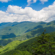
Hiking among the giants of the East. That’s what you’re doing when you take the Blue Ridge Parkway to Mt. Mitchell State Park for this trek on the Mountains to Sea Trail in the Black Mountains. With fabulous views of the Blacks and the Great Craggy Range, and closeup experiences with gnarly old growth fir and spruce krummholz, this stretch of the MtS is some...
Learn More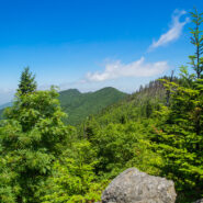
This hike will introduce you to a good cross section of the trails found in Mt. Mitchell State Park high atop the Black Mountains in Western North Carolina. Mt. Mitchell is the highest point in the Eastern United States at 6,684′, in fact six of the 10 highest peaks are found in the Blacks. The climate of the Black Mountains is more like Canada than North Carolina....
Learn More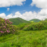
June means catawba rhododendron at Craggy Gardens. Located northeast of Asheville on the Blue Ridge Parkway, Craggy Gardens is loaded with the purple and maroon beauties. There are two short, easy trails near the Visitor Center that access mountaintops for spectacular vista views and bunches and bunches of rhodies. Craggy Pinnacle takes you above 5,800 feet for a view of...
Learn More
There’s a trail from Scenic Hwy 276 that parallels the Blue Ridge Parkway as it winds around 10 ridges and makes 13 easy stream crossings on its way to the Pisgah Inn on the Parkway. Buck Spring Trail eventually ends up at the site of the former hunting lodge of George W. Vanderbilt II, the father of Pisgah National Forest. In the spring this trail is alive with...
Learn More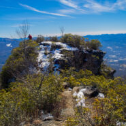
Pinnacle Park is an 1,100 acre tract of land owned by the town of Sylva in Jackson County, NC that was previously used as the community watershed. In 1991 it was leased to the Pinnacle Park Foundation for developing hiking trails that pass by streams, waterfalls, and beautiful long distance vistas. The Pinnacle, where the park got its name, is a large rocky outcropping...
Learn More
Graveyard Fields is an anomaly — a high mountain meadow and bog surrounded by 6,000 foot mountain peaks. The wide-open spaces found at Graveyard Fields are a rarity, an exception in the otherwise lush and densely forested slopes of Pisgah National Forest and Shining Rock Wilderness. Popular with locals and tourists alike, no trip to the high country of Western...
Learn More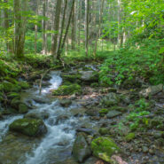
Looking to do some ridge hiking down, down, down from the Blue Ridge Parkway into Pisgah National Forest? Overlooking North Mills River, the Little Pisgah Ridge starts at 4,800′, then drops down into the Big Creek drainage some 2,100 feet below. Catch your views of the mountains on the Parkway before you start because this is a heavily forested hike that instead...
Learn More
Back to Rough Butt Bald Overlook on the Blue Ridge Parkway, and another visit to the Mountains to Sea Trail. The MST follows, or remains close to the Parkway through much of Western North Carolina, so there are a number of easily accessible jumping off points that head into the backcountry. Middle Prong Wilderness was designated in 1984 and spans rugged high-elevation...
Learn More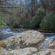
Southeast of the Cradle of Forestry National Historical Site is a remote area of Pisgah National Forest with trails that will take you along ridge lines with views of the Blue Ridge Parkway and Looking Glass Rock, then follow creeks and streams as they tumble down the mountains to the western end of South Mills River. You will encounter names like Squirrel Gap, Glady...
Learn More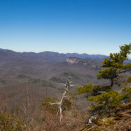
Cedar Rock is one of several granite pluton monoliths found in the Davidson River area of Pisgah National Forest. More difficult to get to than its nearby brethren, Looking Glass and John Rock, Cedar Rock has outstanding long distance views from both the east and west sides of its summit. You will have to work to get there, climbing nearly 1,700 feet from the valley...
Learn More
Quite frequently in winter, the Blue Ridge Parkway will be closed for snow and ice. Not great fun for those who wish to drive along the beautiful ridges. Ah — but it’s the perfect time for hikers to get out on the trails that parallel the Parkway — like the Mountains to Sea. Between Pigeon Gap and Bennett Gap at miles 412-414 the Mountains to Sea Trail...
Learn More
The Black Balsam area of Pisgah National Forest is surrounded by Middle Prong Wilderness on the west, and Shining Rock Wilderness on the east. Some of the best hiking found in Western North Carolina lies in this high country just north of the Blue Ridge Parkway. At the end of Black Balsam Road at milepost 420 on the Parkway, the Ivestor Gap Trail will take you deep into...
Learn More
Between mileposts 423 and 424 on the Blue Ridge Parkway, Scenic Hwy 215 crosses at Beech Gap. If you head about 1/4 mile north on 215, the famous Mountains to Sea Trail crosses from the Black Balsam area into Middle Prong Wilderness. The MtS winds through an ever-changing forest that runs the gamut of evergreens found in the high country of Western North Carolina. Past...
Learn More
Pilot Rock is another of the granite plutons found in the Pisgah Ranger District of Pisgah National Forest. Not as spectacular as it’s more famous cousin, Looking Glass Rock, Pilot still offers remarkable views of the Blue Ridge Parkway and national forest, including the Cradle of Forestry National Historical Site. It’s a short mile climb of almost 700 feet...
Learn More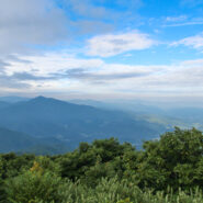
Named after the Biblical mount where Moses first saw the Promised Land, Mt. Pisgah is the landmark that gave Pisgah National Forest its name. Located on the border of Buncombe and Haywood counties in NC, close to the point where Transylvania and Henderson meet them, the mountain is easily accessible via a hiking trail from the Blue Ridge Parkway. Mt. Pisgah is topped...
Learn More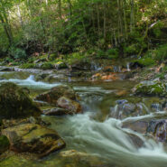
The southeast corner of Shining Rock Wilderness is filled with rivers, creeks and streams tumbling down from the mountains that rise above 6000 feet in the high country. Included among these waterways is the East Fork of the Pigeon River, otherwise known as Big East Fork. A trail follows the river from Hwy 276 to the confluence with Greasy Cove Prong and beyond. This Big...
Learn More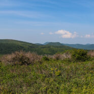
Milepost 420 on the Blue Ridge Parkway is where you will find Black Balsam Road. It’s a short drive to a spruce forest where the Art Loeb Trail crosses the road and heads up onto the balds. This is North Carolina high country. There are several mountains greater than 6000 feet with treeless summits, affording spectacular 360° views of the surrounding Blue...
Learn More
Nestled in the woods of Pisgah National Forest in Asheville, the North Carolina Arboretum is a 434 acre public garden located within the Bent Creek Experimental Forest. Set amid rolling hills just off mile 393 of the Blue Ridge Parkway, the Arboretum offers more than ten miles of groomed hiking trails that are suitable for all ages. Home to one of the finest, most unique...
Learn More
This is a two-part hike with a short drive on a forest service road in between. Both the Case Camp Ridge Trail and the North Face Trail start on Forest Road 475B in Pisgah National Forest. The first climbs 1000 feet in 1.7 miles to the Blue Ridge Parkway near Cherry Gap at mile 416. It’s a short walk from the trail to the Cherry Cove Overlook and a close-up view of...
Learn More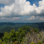
Pilot Mountain stands 5084 feet above the western edge of Pisgah National Forest, near the Blue Ridge Parkway and Looking Glass Rock. There are three ways to get to its summit, but the one I enjoy most is the section of the Art Loeb Trail from Gloucester Gap along Forest Road 475. It isn’t particularly long, but it is quite strenuous. You will get your exercise...
Learn More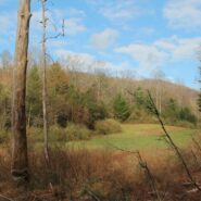
North Mills River Recreation Area in Pisgah National Forest, along with its brother at South Mills River, has a rich trail system. It covers the Pisgah Ridge at the Blue Ridge Parkway down to the North Mills River. A combination of trails leading from the Trace Ridge Trailhead at the recreation area go up, over, and around Coffee Pot Mountain on the way up to the...
Learn More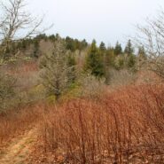
The Mountains to Sea Trail spans the width of North Carolina, running from the Great Smoky Mountains in the west, to the Outer Banks of Coastal Carolina. Much of the trail in the mountainous part of the state is near or parallels the Blue Ridge Parkway. This section of the MST along the parkway has been designated a National Recreation Trail. With elevations well above...
Learn More
Thompson Creek Trail climbs Thompson Ridge from Forest Road 1206 to a point just below the Pisgah Inn on the Blue Ridge Parkway. To the southwest it overlooks the Cradle of Forestry National Historic Site and the Pink Beds. To the east it crosses from Transylvania County into Henderson County and joins the Pilot Rock Trail along the Slate Rock Ridge for the descent...
Learn More I am Jeff Clark, founder of Internet Brothers, producer of this blog, and passionate about hiking. I live in Western NC near the Blue Ridge and Great Smoky Mountains. Pisgah and Nantahala National Forests are just out my door, so the content will focus on these areas, but let me know what you would like to see on the site.


Copyright © 2011-2023 Internet Brothers. All Rights Reserved. ISSN 2324-6057
Designed by Elegant Themes | Powered by Wordpress | Logo by Design Aspirations