If you’d polled Kimberley Brookshire’s friends a couple years ago, they’d likely have said the chances were slim to none that the Charlotte resident would ever think seriously about leaving it all behind to hike more than 2,000 miles through North Carolina.
“I wasn’t much of an outdoors person,” said Brookshire, 32.
But she is now. Last fall, Brookshire became the first woman to complete a “yoyo hike” of the Mountains-to-Sea Trail. In plain English, she hiked the 1,200-mile route from Clingmans Dome in the Great Smoky Mountains National Park to Jockey’s Ridge on the Outer Banks and then turned around to do the whole thing over again. She finished the trek in November 2016, 206 days after setting out solo.
After years of working in the fashion industry — as a magazine writer and then as a teacher of young girls — Brookshire had the itch to try something different. She’d recently discovered that she enjoyed day hiking, and with the beginning of 2015 she resolved to try a long-distance hike, something that was completely outside of her comfort zone. The next year was devoted to reading books, gathering gear and taking survival courses.
Finally, she was ready. She took leave from her job as a nanny, sublet her apartment and embarked solo on the cross-state trek.
“At first it was terrifying,” Brookshire said. “I had never camped by myself or spent the night outside by myself except for maybe once at my house to practice, so it was a little strange. All the noises — I just know it was something that was going to come and eat me or tear my tent apart. It took about two weeks to really feel good in my tent.
“After that I slept the best I’d ever slept in my life.”
Forty years ago this week, state and federal officials in Missouri issued a dry document to announce a grand ambition.
In a 43-page proposal dated February 7, 1977, they stated their aim to blaze a footpath through the Ozarks, the rugged highlands that roll across southern Missouri. It wouldn’t be easy. The native flora, fauna, terrain and certain human occupants made that area, for hiking purposes, hostile territory.
The planners envisioned an “Ozark Trail” that could start near St. Louis and snake its way south over the region’s hills and hollers toward Arkansas, using as much public land as possible. An eastern spur would swing across Johnson Shut-Ins and Missouri’s highest point, Taum Sauk Mountain.
The state felt pressure to deliver such a corridor. In places like St. Louis, hiking was booming. Folks now enjoyed the requisite free time (thanks to labor reforms) and mobility (thanks to automobiles and interstates) to wheel out to the countryside, tramp around and breathe the forest air.
But the Ozark Trail remains unfinished today. It’s not that demand for hiking trails has flagged. According to the DNR’s most recent citizen survey, “trails are the most popular type of outdoor recreation facility in Missouri and the one that residents most want to see increased.”
No, the Ozark Trail isn’t finished, and perhaps never will be, because the last third is the most daunting: The trail must somehow traverse seven gaps of mostly private property — a combined 162 miles through eight different counties — and in a region that has historically cast a suspicious eye toward government, outsiders and recreation projects.
Adventures in the American Southwest are trips of a lifetime that will challenge you physically and engross you spiritually, leaving an unforgettable and enduring impression of the richest wild places on the planet. The Southwest contains literally thousands of amazing hikes. Therefore, Southwest Discoveries decided to separate the wheat from the chaff and give you the absolute cream of the crop. They rounded up 7 of the Grandest Adventures in the Southwest, treks they have experienced firsthand.
As you immerse yourself in this landscape, you will understand why hiking in the Southwest should be on every adventurer’s travel list. Experiencing it fully isn’t just about putting one foot in front of another; it’s about stepping into the geology, history and stupendous scenery of canyon country.
First up on our list of the 7 Grandest Adventures in the Southwest, Buckskin Gulch. Trekking Buckskin Gulch and Paria Canyon is about walking down narrow gorges; places where sunlight seldom enters obscured from even the most intrepid of hikers. When you journey down these two canyons you enter the sublime.
The Paria Canyon – Vermillion Cliffs Wilderness beckons adventurers who hanker for solitude, scenic glory and the chance to explore some of the most majestic canyons in the world. Serpentine red rock walls are streaked with desert varnish and canyons are so narrow in places that the sky is reduced to a narrow ribbon of blue. Navajo Sandstone cliffs tower 1,500 feet overhead. Buckskin Gulch is the longest slot canyon in the world.
It took the world a long time to discover Patagonia, the trendy adventure area shared by both southern Chile and Argentina. While other mountaineers had been hiking and climbing the Alps and Rockies for over a century, Patagonia wasn’t explored much until the 1980s. In fact, the recreational area didn’t become mainstream until the 21st century, when more accessible transportation, lodging and tourist amenities were finally added.
What’s all the fuss about? In between knife-like mountains, this is arguably the best place in the world to see moving glaciers. It is also a great place to meet gentle but playful people.
When people say they’re “going to Patagonia,” they usually mean the massifs of either Torres Del Paine (pronounced “Piney”) in Chile or Fitz Roy in Argentina. After all, greater Patagonia is nearly twice the size of Texas and mostly barren.
What makes these mountains so special, then? 1) Both have vertical drops of around 10,000 feet from the viewing floor, which appears more impressive than mountains of equal height but with lesser prominence. 2) These peaks are more like steeples than the traditional triangles you’re used to seeing. Like mountain-sized shanks dusted with powdered sugar. This effect makes them appear more sinister than other ranges. Indeed, one indigenousness interpretation of Paine reputedly means “don’t go there.”
Perito Moreno Glacier may be the most impressive and powerful sight you will ever see (and hear). Massive doesn’t begin to describe it.
From lowering blood pressure and decreasing anxiety to reducing the risk of a heart disease diagnosis or reversing the course of diabetes, the benefits of hiking are numerous.
The American Hiking Society also includes weight loss, stabilizing cholesterol levels and reversing the effects of osteoporosis among the many benefits. Hiking can be more than a good time — it can be good for you.
Novice hikers, however, might not want to go it alone on the trails, and that’s where hike leaders come in.
One of the most important traits to being a good hike leader is to be able to provide a perimeter of structure and direction without controlling every aspect of the hike. You must be informed and have good hiking skills, survival skills, first aid experience, and ability to be flexible with the situations as they arrive.
Risk management skills are a priority. Reviewing the trails, trail maps, and possible alternative trail access ahead of time is crucial. The ability to review hiker’s expectations and skillset prior to an event will better ensure that there is a good match between the hike and the hikers. A good leader must be prepared for a variety of situations before they occur so that you can minimize and, hopefully, prevent unpleasant or unsafe situations from occurring in the first place.
Join the Pacolet Area Conservancy (PAC) for five Friday hikes offered to the public, free of charge, this spring.
The community is invited to enjoy the beauty of our Carolinas with PAC. Come see what the work of many conservation organizations have done for the preservation of area natural resources and take in the beauty of the arrival of spring.
Starting February 17, 2017 PAC’s first trek will head to DuPont State Forest for an approximately 7-mile, easy, loop hike. The trail will lead hikers along old roadbeds, through a managed pine forest and past Thomas cemetery, named for the family that lived near the site in the 19th century. Hikers will take a short jaunt to view Wintergreen Falls, and then return to the main loop, making their way back to the parking area.
On March 3, the hike will take place in Pisgah National Forest, along the Coontree loop and Bennett Gap trails. On this moderate, 6.6-mile hike in the shape of a lollipop, participants will enjoy terrific views of the surrounding mountains along Bennett Gap before descending and completing the journey with a walk along Coontree Creek.
On March 17, the group will head to the Mountain Bridge Wilderness Area for a 5.6-mile, moderate, out and back hike along the Pinnacle Pass and Naturaland Trust trails to Moonshine Falls.
On March 31, hikers head back to Pisgah National Forest for a moderate 8-mile, loop hike starting from the Davidson River Campground. The hike will follow the Davidson River to the North Slope trail through a dense deciduous forest, and then veer onto the Connector trail to the Art Loeb trail which follows Shut-in Ridge before heading back down to the campground and parking area.
Finally, on April 14, the group heads to the Great Smoky Mountains National Park for a 6.8-mile, moderate hike along Asbury Trail which straddles the boundary between the Great Smoky Mountain National Park and the Appalachian Ranger District of Pisgah National Forest.
If you are interested in attending the PAC spring hikes and would like more information, please call the PAC office at 828-859-5060 or e-mail [email protected]. You can also find information on PAC’s website, www.pacolet.org, and on PAC’s Facebook page.
PAC invites the public to participate in a “Hiking Challenge.” Complete all five of the hikes this spring and receive a custom bumper sticker acknowledging your accomplishment.
PAC is a 501(c)(3) non-profit conservation organization (land trust) founded in 1989 to protect and conserve natural resources in the Foothills of North Carolina and the Upstate of South Carolina, with emphasis on the lands and waterways with scenic, ecologic or agricultural significance in the North Pacolet and Green River watersheds.
Download Spring Hiking Series Brochure…
Unified Warrior Foundation is planning a Continental Divide Trail hike, beginning in late March 2017.
“Unless the issue of veteran suicide is constantly kept in the minds of Americans, it will silently disappear as many important issues do because of the vast amount of information we all have to compete with,” said Eshleman. “Keeping this issue alive is a fight in itself. Just as we fought for our brothers in combat, we must continue to fight to bring assistance and improvement to the current processes and solutions for them and their families.”
Unified Warrior Foundation has chosen foundations they work with to assist veterans. The Tragedy Assistance Program for Survivors (TAPS), America’s Fund and Guardian Overwatch have all demonstrated their commitment to helping veterans. These organizations will be featured in Podcasts delivered from the trail over the five-month journey.
An additional endeavor for this hike from the Canadian border in Northwest Montana to the Mexico border in Southeast New Mexico will be to pass on the benefits of the outdoors and a little knowledge to the youth in the U.S.; many who have never or may never have the opportunity to see this part of America and be involved in something so important.
Just a few clicks on a website and people can access information on 2,958 miles of trails in Kansas.
That’s right, trails that you can hike, run, bike, or horseback ride. With a few more seconds worth of clicks you can find which trails are within an hour of your house, which ones you can complete in a half-day and which ones are graveled or paved.
You can also learn what’s happening, that day or in the near future, for more than 30 outdoor activities ranging from archery shoots to wildlife viewing from all corners of Kansas, hosted by some of 119 orgaanizations. It’s all on getoutdoorskansas.org.
“Basically it’s a website that provides a free, and quick, way for organizations or individuals to post their outdoors events. It also for the public to view those activities or find any trail we have,” said Mike Goodwin, of the Kansas Trails Council and originator of the online idea.
Goodwin said the project has about filled his original dream of better trail education, and proved his thought that Kansas had more miles of trails than most realized.
All of those miles have been walked, biked, floated or ridden with GPS units to get exact readings for locations and length. Trails range from paved city park walks of a few hundred yards to the Flint Hills Nature Trail, which is 117 miles long.
Did the fires hurt wildlife?
The impact will unlikely be large enough to affect overall populations, and long-term the fires will result in a flush of green in the understory that will ultimately benefit wildlife.
Will the fires increase the chance of flooding and landslides?
With more than a month elapsed since the report’s Dec. 12 completion and multiple heavy rains in the rear-view mirror, there haven’t seemed to be any issues. Many areas that the team completing the report initially observed to have water-repellent soil seem to be absorbing water much more readily.
Is a spring fire season likely?
To a degree, the fire season could depend on the scruples of people in the area. Of the 20-plus fires that burned through WNC last fall, only one is thought to have resulted from natural causes. The rest were caused by humans, either accidentally or on purpose.
How did the fires affect the Appalachian Trail?
South of the Smokies, 58 miles of the A.T. run through North Carolina. Of those 58 miles, 26 miles were part of the burned area. Of those 26 miles, about 90 percent experienced pretty mild burning, about the same level you’d get with a prescribed burn. However, about 10 percent burned hot, consuming wooden anti-erosion features on the trail and creating hazards like holes in the ground and dead trees.
More questions and details here…
Are you sick of going to bed late and waking up tired? Then grab your hiking boots and a tent. A new study suggests that a couple days of camping in the great outdoors can reset your circadian clock and help you get more sleep.
The circadian clock is an internal clock that tells your body when it’s time to go to sleep and when it’s time to wake up. Scientists track this clock by measuring the amount of melatonin circulating in a person’s blood at any given time.
In a healthy sleeper, melatonin levels rise a few hours before bedtime, stay high through the night, and then settle back down to daytime levels when it’s time to wake up. The span of time when melatonin levels are elevated is known as biological night.
In our modern society biological night does not usually coincide with night in the natural world. Most of us stay up many hours past sunset and would probably sleep in many hours after sunrise if we could.
Researchers recruited 14 physically active volunteers in their 20s and 30s. Nine went on a weekend camping trip, while the other five stayed home. At the end of the weekend, the authors monitored the volunteers’ melatonin levels to see if there had been any shift in the timing of their biological night.
The researchers report that in just two days, the campers’ circadian clocks shifted so that their melatonin levels began to rise more than an hour earlier then they did in the days before they left on the trip.
The first person to hike the full length of the Appalachian Trail, a white man named Earl V. Shaffer, wanted to “walk the Army out of his system.” That was in 1948. Since the 1970s, when 775 hikers completed the trail, the number of “thru-hikers” has doubled each decade so that in the 2000s, close to 6,000 hikers covered all 2,190 miles.
Most of those people still look like Shaffer—they’re white men. Only about a quarter of thru-hikers are women, according to the Appalachian Trail Conservancy, and though there’s little information about the racial breakdown of thru-hikers, it’s safe to say that the vast majority of them are white.
Last year, Rahawa Haile, a writer now based in Oakland, California, became one of the very few black women to attempt to hike the entire trail. (She was able to find exactly one other attempting the feat in 2016.) In March, she began in Georgia, the more popular end of the trail to start on, and by the middle of October had hiked its entire length. She carried along with her, too, a series of books by black authors, which she left in trail shelters along the way.
Haile spoke to Atlas Obscura about the challenges and joys of hiking all those miles and the particular experience of being one of the few people of color spending months on the trail.
There’s just something magical about a great summit view. Whether the hike spans miles or minutes, a good climb to a spectacular view makes a great workout – and, hey, at least the return hike is (usually) downhill. Hike these great Georgia hikes to a favorite to savor the view from the top and catch some celebration time at the summit. Georgia’s beauty is simply stunning.
These 10 trails explore Georgia from places spread all over the map, from the southern Appalachian Mountains north of Atlanta to the sandy Georgia coastline near Savannah. Mid-state, you’ll scale a Native American mound near Macon to catch views of a beautiful riverside marsh. And near Columbus, you’ll explore a lofty mountain ridge that rises high above the surrounding plains. Up for the challenge? You’ll rack up some great memories on the trail, and catch some stunning views along the way.
These great Georgia hikes travel to favorite overlooks, catching stunning views of Georgia’s mountains, coast and plains.
Thru-hikers discover how environmentally degrading backpacking can be. They find countless coolers and campsites full of trash, and eating individually wrapped packets of ramen and Pop-Tarts generates an uncomfortable amount of waste.
Hikers have ideas for making long-distance backpacking more environmentally sound. Though it’s nearly impossible to avoid creating some amount of trash, many hikers found that making mindful purchases, buying in bulk and adhering to Leave No Trace principles helped mitigate environmental damage.
Here are a few suggestions:
Though hikers are resourceful people, there is still room for improvement in the way we treat the environment. With research and some creativity, future generations will be able to hike these precious wilderness trails as they are meant to be enjoyed.
Best known for its groves of Sequoia trees, Kings Canyon National Park spans a significant portion of the Sierra Nevada mountain range in California. But it’s not just these giant trees that attract visitors to the so-called Land of Giants, and neighboring Sequoia National Park. Deep canyons, lush valleys, snow-capped peaks, and terrain ranging from 1,000 to 14,000 feet are all part of the appeal—though the world’s largest trees are certainly a highlight.
A visit to Kings Canyon—to the old growth trees that inspired the writings of John Muir himself—is accessible to all travelers, thanks to a tangle of hiking trails ranging from novice, paved paths to advanced, multi-day trips. And you don’t need any technical skills at all to be impressed by the height, and age, of the iconic trees towering over the California coast.
The main attraction of Kings Canyon National Park is the Sequoia groves. While their imposing height is impressive, travelers may be more impressed by the age of these natural landmarks. Many of the trees are between 1,800 and 2,700 years old.
Grants Grove, located just off of Highway 180, boasts some exceptionally large sequoias, in addition to a great vantage point over the General Grant tree. There is a network of trails in this grove that allow visitors to wander among the primordial forests, meadows, and waterfalls. Choose from a variety of hikes that can last anywhere from one hour to a full day or more.
If you have the time, take the Congress Trail hike from the General Sherman Tree (the world’s largest tree by volume) up to the top of the granite dome known as Moro Rock.
Of course, there’s more to see at Kings Canyon National Park than just trees. A scenic byway offers a number of picturesque viewpoints punctuated by educational exhibits, while rock climbing and tours of the fragile crystal caves offer an unexpected perspective of a park best known for its boughs.
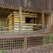
The evolution of historic Elkmont soon should be taking another step forward.
The historic former logging/resort community in the Great Smoky Mountains National Park has been in an evolving state since 2009 when the National Park Service announced a plan to preserve part of the community after conducting an environmental impact study from 1992 through 2008.
The plan has been to preserve 19 structures at Elkmont while razing 55. Two of those structures – the Appalachian Clubhouse and Spence Cabin – have already been renovated and preserved. The park has now received funding to preserve four more structures and tear down 29.
Elkmont has been among the park’s most visited attractions. Located off Fighting Creek Gap Road, it began as a logging community in the late 1800s before evolving into a vacation resort. The park allowed owners to keep their cabins there until the early 1990s. It has since fallen into disrepair.
Those scheduled for preservation will be much like the structures in Cades Cove that are stabilized and made safe for visitors to tour.
The federal hiring freeze of all civilian employees, ordered by President Trump on Jan. 23, 2017, could negatively impact employment in Western North Carolina and the public services those agencies provide. According to the executive order, no vacant positions existing at noon Jan. 22 may be filled and no new positions may be created. The order does not include or apply to military personnel or positions with national security or public safety. The order also prohibits the hiring of contract workers who might be hired to circumvent the hiring freeze.
The Asheville area is home to some 3,300 federal employees and many federal agencies, including two of the most visited parks in the National Park Service, one of the most visited national forests in the United States, NOAA’s National Centers for Environmental Information, which tracks all climate and weather data for the country, and many others such as the U.S. Fish and Wildlife Service, the U.S. Department of Agriculture and Department of Veterans Affairs.
The Blue Ridge Parkway, which runs through Asheville on its 469-mile linear path, received 15.2 million visitors in 2016. The Great Smoky Mountains National Park, which has a half-million acres across North Carolina and Tennessee, set a visitation record last year with 11.3 million visitors.
The Pisgah and Nantahala national forests in WNC comprise more than 1 million acres of land. The Pisgah National Forest is the second busiest in the country, with an estimated 6 million visitors a year.
Seasonal workers, hired for the busiest months from April to October, make up close to half the parks’ workforce. Their hiring might be delayed, which could lead to a delay in park and forest facility openings.
Belair National Park, near Adelaide, Australia is the ideal place to experience a sense of adventure, with many trail options to explore in a beautiful bushland setting.
In 1840, the land was set aside by Governor George Gawler as a government farm. It was later used to farm hay and care for police horses in the gold escort and other services.
Through the early to mid-1900s, approaches to the preservation of native flora and fauna in the park changed so that all future planting in the area would be restricted to native South Australian plants. As a result, the last non-native planting in the park was of 700 Japanese cherry trees. Remains of the plantation can be found in the park along RSL walk.
Today, there are many options available for those visiting the park, which has woodlands and lakes, shared-use trails, cricket pitches and tennis courts to hire. You can explore Old Government House, and let the kids go wild on the adventure playground.
The trail runs for 45 miles from downtown Harrisburg to Karmak in southern Illinois. The tail is managed by Illinois Department of Natural Resouces with an additional 2.5 miles managed by the City of Harrisburg. A 543-foot long tunnel gave the nearby town its name, and now the trail.
Beginning in Harrisburg, the trail is at 370 feet above sea level, rising to 680 feet at Tunnel Hill and then dropping to 340 feet at Karnak. The trail crosses 23 trestles ranging from 34 feet long to 450 feet. The longest, Breeden Trestle, is also the highest at 90 feet. The abandoned railroad right-of-way varies between 40 and 200 feet in width.
The Tunnel Hill Trail is part of a former railroad founded by Civil War General Ambrose Burnside. In 1872 Burnside and others began the Vincennes & Cairo Railroad, which connected Vincennes, Indiana and Cariro, Illinois.
The central section of Tunnel Hill Trail passes through the Shawnee National Forest, Illinois’ only national forest. The southern section of the trail traverses the Cache River State Natural Area, a significant state, national, and international wetland resource.
 I am Jeff Clark, founder of Internet Brothers, producer of this blog, and passionate about hiking. I live in Western NC near the Blue Ridge and Great Smoky Mountains. Pisgah and Nantahala National Forests are just out my door, so the content will focus on these areas, but let me know what you would like to see on the site.


Copyright © 2011-2023 Internet Brothers. All Rights Reserved. ISSN 2324-6057
Designed by Elegant Themes | Powered by Wordpress | Logo by Design Aspirations