Partnering with the city of Leavenworth Parks and Recreation Department, a nonprofit organization is helping to provide a new mission for military veterans transitioning back into civilian life.
Military veterans are invited to join forces with community members in cleaning and creating trails and camp sites in Leavenworth, Kansas.
The trail creation and restoration work also includes construction of picnic and fishing areas. The program also welcomes volunteer service from active duty military personnel.
Construction is taking place at VA Memorial Park, a 72-acre tract of land located in the wooded area northeast of the Eisenhower VA Medical Center.
The program, Into the Woods, is the brainchild of Chelsea Barto, a former Army combat medic. She said military personnel are goal-minded and mission-oriented. “This is their next mission,” she said. “It gets them involved in their community.”
Barto said the program is associated with The Mission Continues, a nonprofit organization that empowers service members and veterans facing the challenge of adjusting to life at home.
Blooming desert wildflowers served as the perfect backdrop for Friends of the Desert Mountains to receive the $25,000 Coachella Valley Spotlight grant from the H.N. and Frances C. Berger Foundation. Each year more than 20,000 valley residents and visitors enjoy the Santa Rosa & San Jacinto Mountains National Monument Visitor Center, off Highway 74, and hiking trails, which the organization supports.
Friends of the Desert Mountains recognizes the ever-increasing popularity of the Coachella Valley hiking trails among residents and visitors, and aims to improve safety, usability, and the enjoyment of the entire trail system. Grant funds will benefit the organization’s Trail Stewardship Program.
“We plan to use a portion of the grant proceeds to enhance the Ed Hastey Trail, which is the trail accessible to strollers and wheelchairs, to include tactile and other sensory experiences specifically designed for those with vision, hearing, and other sensory impairments,” said Tammy Martin, Executive Director of Friends of the Desert Mountains.
Friends of the Desert Mountains maintains more than 500 miles of recreational, hiking, biking, equestrian trails in the Coachella Valley. Although much of the work for the program is carried out by volunteers, the program incurs costs associated with the upkeep and replacement of tools, sign and exhibit printing, signposts and associated materials, and staff time related to coordination and design.
With the mighty Himalayas and several other locations throughout the country offering trekking choices, India makes for an ideal destination for adventure lovers.
Starting from short day trips to longer duration intensive routes, people of various fitness levels can find suitable options. Star gazing, pilgrimage and expeditions to see flowers in bloom are among many of the reasons trekkers are undertaking their journeys, besides the immersive experience of being in nature. With the growth in online trekking communities and clubs, Indian as well as foreign travelers are increasingly taking to exploring Indian hills on foot.
A plethora of options are available for trekkers in India, with the northern part of the country being quite well-known and explored. Some of the places to head to in North India are lined along the hills of Uttarakhand with Valley of Flowers, Binsar Trek, and in Himachal Pradesh with Spiti Valley and Chandratal. Lake Trekking is also a great option and so is the Leh-Ladakh region in the state of Jammu and Kashmir.
However, with some breathtaking views offered by West Bengal’s Sandakphu trek and Sikkim’s Yuksom and Goecha La, the eastern part of India is a strong contender. South India is not too far behind either, with destinations like Ooty and Wayanad and for those looking to explore western India, Rajmachi Valley in Maharashtra is a great option.
Maybe it’s the beard.
“I really enjoy having my beard full of ice,” Benny Braden, 44, said on coming out of the Great Smoky Mountains National Park after another long hike. “It was that way today – just getting covered head to toe in ice.”
Braden, from Harriman, TN has been in the park a lot since Jan. 1. He’s on his way to setting a record March 18th for hiking all of the park’s trails – more than 770 miles – in the shortest amount of time.
If all goes well, he should walk into the Sugarlands Visitor Center grounds having finished in two months and 19 days. This will beat the mark of four months and 12 days set by Sharon Spezia.
Braden got the idea for the beard and the hike last year while he was section-hiking a part of the Appalachian Trail from Springer Mountain in Georgia to Damascus, Va.
“I would go out once a month and hike a few days, then I would come home. I was on a short hike in the Smokies and stayed on Mount LeConte. Believe it or not, it was when the (Chimney Tops 2) fire was going on. We were on a cliff top and watched the fire below us. I got the idea, ‘Why not hike all of the trails in the Smokies?’”
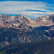
The view atop Tenderfoot Mountain in Summit County, Colorado is so expansive it can barely be captured in a camera lens. On the far left is Keystone Resort and glimpses of 13ers Mount Guyot and Bald Mountain. Also on the left, the Tenmile Range and Breckenridge Ski Resort unfold with unobstructed clarity. All the way down the line, I count the 10 peaks. The town of Frisco rests straight ahead directly underneath Mount Royal.
The sleepy town of Dillon rests at the base of the mountain, nestled along the shoreline of Lake Dillon. Wildernest Road is traceable as it snakes its way up the hillside underneath Buffalo Mountain. To the right, the mighty Gore Range pops up dramatically, starting with the noticeable Buffalo Mountain. From this vantage point, the entire Gore Range is in plain site. This hike offers so much to the beholder and at the top of Tenderfoot Mountain hikers are given clear views of Summit County in its entirety.
Tenderfoot Trail is a relatively easy hike: not much elevation gain and not very long. To reach Tenderfoot Mountain travel on the Oro Grande Trail for about half a mile. Oro Grande is a gentle trail that weaves through aspen groves until topping out on a high hill.
A small signpost on the left indicates the start of the Tenderfoot Trail. The trail steepens briefly during this initial portion. At this point the views are to your back, as the trail takes you uphill towards the Tenderfoot summit.
When people grieve, they often need to do something physical to help them along. Some folks build things. Another option is hiking.
Set a goal each day to reach a scenic viewpoint, but also try to find a place along the way where you connect to something solid and real.
In the months following a loved one’s death, home is an unending flurry of details, doubts and despair, and you are unable to focus on anything for very long. Buddhism calls this “monkey mind,” when hundreds of thoughts are screeching, chattering, and jumping around, each wanting your attention.
When you’re alone on a backcountry trail, your mind quiets. Hiking where bears live keeps your senses focused on the present. You don’t want to be thinking about what happened last month and miss the slight movement in the bushes.
As the hours drag on of putting one foot in front of the other, you will begin to remember who you am. The rhythm of hiking moves you out of the labyrinth of thoughts and into the wisdom of the body. Your mind clears. Your battered heart shows up. Your spirits rise.
Remember what is important, come to understand what has happened, and make the necessary adjustments to your life. Nature puts grief in perspective and reminds you that you are part of something much greater.
Hiking is a walking meditation.
Geeks love nature, too. Mendel Kurland, a self-professed geek, figured that out in a hurry after hiking with a co-worker last year. The two talked about the fun of spending time outdoors, and on a whim afterward, he snapped up the domain name hikingwithgeeks.com. Then, last October, he started a Hiking With Geeks meetup group, hoping to lure a few nerds from their computers, labs and classrooms into the great outdoors.
“Over that weekend I had 200 people sign up. I was just blown away,” says Kurland, who works in community relations for GoDaddy. “We went out for our first hike shortly after that, and a bunch of people showed up — all of them legitimate geeks from all over the city.”
Geeks of all stripes, ages and backgrounds, from developers and designers to scientists and programmers, felt the tug of Mother Nature.
“Geeks have a lot in common with each other, whether it’s being introverted or the type of work they do,” Kurland says. “It’s almost like the hiking is the second part of it and the relationship stuff is the important piece. A lot of developers don’t go out and aren’t super social sometimes.”
In less than 30 days, the group grew to more than 1,700 members.
A spectacular bloom of wildflowers is underway at Anza Borrego Desert State Park in California, and by the middle of March, it’s expected to just get better and better, according to park officials.
The area has been deluged with rain this season and the Borrego Desert is full of green with flowers in stages of both bud and blooms, a press release issued by the park is reporting. “We are on the ‘uphill side’ of the peak bloom and experiencing more open flowers with each passing sunny day,” the release states.
According to park officials, there are many locations where open flowers can be seen, especially for those willing to wander among the buds and blooms throughout the park.
“A top location is anywhere within a two-mile stretch of the Coyote Canyon Jeep Road, north of the north end of DiGiorgio Road with abundant Peirson’s Primoses and others, including a few remarkable Desert Lilies,” the park reported.
Patches of pink sand, verbena, dune evening primroses with wide white petals, yellow desert sunflowers and desert lilies can all be found throughout the Henderson Canyon Road area.
“Around Borrego Springs, roadsides are lined with yellow Desert Dandelions and other wildflowers. These flowers are best seen in the morning, as some blossoms close in the afternoon,” the release states.
One place to start the Camino de Santiage is along “The French Way,” the branch of the Camino that unites various routes through France and across Spain. It is one of the oldest and most-walked trails in the world, dating back by most estimates to the 9th Century.
The Camino de Santiago is said to have begun when the bones of the apostle St. James were discovered by a farmer on a starry night in Galicia, Spain. People from all across Europe came to see the remains, dragging their feet through the same dirt that you can today.
As you walk, you pass small villages where you can refill your water, buy fruit and bread, and collect a stamp in your “pilgrim’s passports.” Walkers are required to receive a stamp in these booklets in two different locations each day to receive the coveted compostela upon reaching the Pilgrim’s office at the end of the walk.
If the office finds that you have walked at least 100 km, which many people accomplish by starting in Sarria and completing the last three days of the journey, you earn the compostela — a scroll covered in Latin, congratulating you on your pilgrimage.
The Camino is full of treasures, and it brings walkers through landscapes that feel ancient and untarnished, but the concrete sprawl and neon-glow of Santiago are creeping back along the route at an alarming rate.
Thankfully, spring is almost here. It’s a great time to get outside and enjoy all that nature has to offer. One of the best ways to get your exercise and see wonderful natural surroundings is hiking and riding a bike.
Here is a collection of 13 amazing trails in Alabama State Parks. Hiking these trails offers a chance to see waterfalls, expansive vistas and abundant wildlife. The descriptionss offer details about the trail, difficulty, length and what you can expect to see on your hike. Some trails can be shared by hikers and bike riders.
For example, the most popular trail at Cheaha State Park is the Bald Rock Boardwalk. There are 3 paths that lead out to Bald Rock Outlook; a boardwalk and a dirt trail, on either side of the boardwalk. The boardwalk leads to an amazing vista at the Bald Rock Outlook.
Or, Chewacla State Park has a great partnership with Central Alabama Mountain Peddlers (CAMP) that offers a great trail system to the public. The park offers 28 miles of trails shared by cyclists and hikers. One trail, the “For Pete’s Sake Trail” is 8 miles long.
So get out and enjoy the great Alabama outdoors at these Alabama State Park trails…
For two decades, Florence Williams could sit on her porch at night and watch the alpenglow on the Rocky Mountains. Then she moved from remote Colorado to Washington, D.C., and started noticing the changes.
“I felt disoriented, overwhelmed, depressed,” she writes in her recent book, The Nature Fix. “My mind had trouble focusing. I couldn’t finish thoughts … and I wasn’t keen to get out of bed.”
Williams was suffering, she says, from nature withdrawal. She spent the next three years digging into the science of how nature works on our brains. In short, it makes us more relaxed, more creative, and more socially connected. She traveled to Japan and Finland, the deserts of Utah and the urban forests of Singapore, to study just how much we stand to gain by bring nature back into our lives.
At a time when more than half of all humans live in cities, the influence of the natural world is at a low ebb, while our understanding of its importance keeps growing. In a recent visit to the Grist offices, Williams talked about how writing this book led her to appreciate the role nature can play in our personal lives.
Congaree National Park visitors not only look out across a flood plain swamp but up as well. Up into the forest canopy that rises to 160 feet high. The Congaree canopy, formed by towering old-growth trees, is taller than that of any forest in the East.
The giant trees include a 167-foot-high loblolly pine. It’s the tallest tree in this wet-and-dry park, the biggest tree of its kind anywhere.
A sky-seeking cherrybark oak and a swamp tupelo fall short of the pine by just 5 feet. The former is the biggest such oak in South Carolina and the latter is a national champion, the biggest tupelo of its species.
Congaree preserves these super-sized trees and thousands more in this bottomland hardwood forest near the confluence of the Congaree and Wateree rivers south of Columbia. The trees were spared from possible logging when a public campaign to conserve the privately owned forest succeeded. Congress in 1976 created Congaree Swamp National Monument with 15,000 acres. In 2003, legislators upgraded the preserve to a national park, which now covers 26,715 acres.
Visitors may hike on 2.4 miles of elevated boardwalks and along 37.8 roundtrip miles of trails, fish Cedar Creek and oxbow lakes and tent camp in a campground or in the backcountry.
The exuberance of spring is impossible to ignore. And for fair-weather walkers, brushing cobwebs off boots and searching out walking poles, it’s like a love affair renewed. Spring walking is a welcome assault on the senses – warmth, light and colour replacing the damp greys and browns of winter.
Everyone has their favourite local walks, but these 25 circular routes have all been chosen for features in the landscape which come alive in spring, whether it be woodlands carpeted with bluebells, wildflowers along river valleys, moorland peaks, coastal paths or National Parks.
Between three and nine miles in length and of varying difficulty of terrain, they stretch from Friston Forest in Sussex to Grizedale Forest in Cumbria, from the Isle of Wight to the Isle of Arran, and from the coast of Cornwall to the coast of Northumbria. These hikes will put a spring in the step of wanderers everywhere.
Look for descriptions and photo galleries here…
The Allegheny National Forest chapter of the North Country Trail Association will hold its eighth annual Allegheny 100 Hiking Challenge (A-100) on June 9-11, 2017.
The hike will take place throughout the Allegheny National Forest, and is billed as an endurance challenge of individual stamina, determination, and resilience. It is not a race.
Hikers will traverse 100 miles, 75 miles, 50 miles or 25 miles of trail through rolling hills and stream valleys in a fifty-hour time period.
Event organizers remind those who are interested that this event is for anyone, regardless of skill level, who wants to test him or herself against the trail. Event organizers also note that cell phone reception is spotty along the length of the trail.
For the 2017 challenge, hikers will travel north to south, from the state Route 346 trailhead, near Willow Bay, to the state Route 66 trailhead, between Marienville and Vowinckel.
Those who are interested should note that the A-100 is an unsupported hike. There will be no first aid or water stations.
Do you follow the North Star? For those sunny days when you’re hiking in the Great Smoky Mountains National Park where the night sky is unfortunately unavailable to assist you with navigation, make sure you’re on the right heading with proper adjustment to your compass.
Did you know your compass needle doesn’t point directly to the north? The earths geomagnetic field exerts varying degrees of influence on your compass needle as it swings around in search of the elusive North Pole. Magnetic declination, a critical map tool for hikers in the know, is the angle of deviation between true north, and what your compass needle is pointing towards.
Magnetic declination within the park is measured in the west, or negative direction, and ranges from -5.6 to -6.3 degrees. Most compasses do not have the ability to delienate tenths of a degree, so you’ll have to “Kentucky Windage” your compass sightings to just to the right or left of the 6 degree mark. You will have to hike a very long distance, on a straight line, to realize any error manifested by a few tenths of a degree.
The map here gives the magnetic declination for many areas in the park as of March 1st, 2017.
Head to Lantau’s southeast to tackle the 18.5 km Chi Ma Wan Country Trail for secluded bays, sweeping panoramas and scattered hamlets along deserted paths.
If you’re heading to Lantau Island for a wild outing, the chances are you’ll be bound for the central hills – to climb either Sunset or Lantau peak, or both – or aiming to stride along nearby stretches of the Lantau Trail. But to the island’s southeast, there’s another area that’s easily overlooked, yet can make for a fine day outing: the Chi Ma Wan (Sesame Bay) Peninsula. The landscape is fashioned from a mass of granite, forming a hilly interior and coastal headlands between small bays.
The Chi Ma Wan Country Trail, at 18.5km, is the longest country trail in Hong Kong. It starts in the north and makes a looping circuit above shorelines and up and over the peninsula’s highest point, Lo Yan Shan. Although it takes eight hours or more to complete the circuit, there are options for following shorter routes.
Although you could explore the peninsula without getting higher or more challenging than hillside contour trails, doing so would mean missing out on the best parts: Lo Yan Shan and the nearby craggy hilltop. At 303 metres, Lo Yan Shan – Old Man Mountain – is the highest point on the peninsula. It affords fine views over the sea east of Lantau, with Hei Ling Chau in the foreground and Peng Chau beyond.
Several mountains are within striking distance of Mexico City. Nevado de Toluca, Mexico’s fourth-highest mountain, rises to the southwest. To the east, climbers can try their luck on the Paso de Cortés, which cuts through the two towering volcanoes Hernán Cortés traveled through when he first saw the Valley of Mexico. Then there’s the closest of the bunch: Ajusco, a nearly 13,000-foot dormant volcano that is actually within the city limits.
Though it’s not impossible to take buses and taxis to Ajusco’s trailheads, the road to the mountain has a reputation for being dangerous and can be complicated if you don’t know the way. If you feel in the mood for a hike, hire a driver who knows the route and can wait for you while you hike.
Tackling Ajusco requires a reasonable level of fitness. Depending on where you start the trail, the entire hike could take up to six hours, so make sure you set aside enough time so you won’t be rushed. Because of the relative remoteness of the mountain, it’s probably best to hike with at least one other person.
Mexico City lies more than 7,000 feet above sea level. The hike up Ajusco includes 4,000 feet of gain, and with the already heightened elevation, it can be more strenuous than flat-landers might expect. Give yourself a few days to acclimate before tackling any mountaineering, and make sure to take plenty of water and sunscreen.
You see that big tree looming over you? Or over your house, your car? Or along the trail at your favorite park?
It could be what we call a “widow maker.” That is, a big tree (or limb) about to fall. Saturated soil that can’t hold upright the weight of big trees has led to a stunning array of downed trees in parks, backyards, front yards… in other words, everywhere.
This week park rangers closed the No. 1 Trail in the Santa Cruz Mountains, the Skyline-to-the-Sea Trail and return loop route on the Sunset Trail at Big Basin Redwoods State Park. The trail leads to Berry Creek Falls, Silver Falls and the Golden Cascade in one of the prettiest canyons in California.
A week ago, rangers counted 15 fallen old-growth redwoods on the trail en route to the falls and another 10 on the way out. Later, ranger Alex Tabone assessed the damage again and said the number had grown to 50. That includes one massive section on the Skyline-to-the-Sea Trail, he said, that has been interrupted by a landslide roughly 400 yards long and 400 yards wide that tossed old-growth redwoods in a heap.
“There’s this big pile of old-growth trees,” he said. “There’s a trail under there some place. I saw this guy on the other side, trying to figure out how to get through, and decided we have to close this trail down.”
 I am Jeff Clark, founder of Internet Brothers, producer of this blog, and passionate about hiking. I live in Western NC near the Blue Ridge and Great Smoky Mountains. Pisgah and Nantahala National Forests are just out my door, so the content will focus on these areas, but let me know what you would like to see on the site.


Copyright © 2011-2023 Internet Brothers. All Rights Reserved. ISSN 2324-6057
Designed by Elegant Themes | Powered by Wordpress | Logo by Design Aspirations