Rescue workers with the Juan County Sheriff’s Department and The U.S. Forest Service evacuated 23 people and three dogs from the San Juan National Forest in Colorado as a wildfire tore through the area. The U.S. Forest Service deployed helicopters for the evacuation.
According to the Office of Emergency Management in San Juan County, the blaze — dubbed the Ice Fire — started on Monday, October 19, 2020 just after 1 p.m. local time in the South Mineral Creek area above the park’s Ice Lakes trailhead, and burned 320 acres by 5 p.m.
Per their last update, the U.S. Forest Service had air and ground “wildland fire crews” working on containing the Ice Fire with “tanker planes and a hotshot squad.”
Just last week, thousands of Colorado residents were forced to evacuate their homes as the Cameron Peak Fire and the CalWood Fire ravaged the state along the Front Range.
The Cameron Peak Fire became the largest fire in Colorado state history — and has burned 204,404 acres.
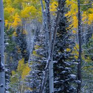
From Colorado to Oregon to Maine, these incredible winter hiking trails offer beautiful views, wildlife-spotting opportunities, and fewer crowds.
If you have a habit of stashing your hiking boots the moment cooler temperatures arrive, you’ve been missing out. In the winter, the nation’s best hiking trails clear out and you can walk for miles without seeing another soul. Strap on a pair of snowshoes and stomp across glittering, snow-covered fields, or avoid the snow entirely and head south, where you’ll find plenty of dry terrain that’s too hot to brave in the summer.
The secret to winter hiking is making sure you have the gear necessary to stay warm, kick through snow, and outsmart the sun. Appropriate footwear and versatile lightweight layers are key. And since the days are shorter, you’ll want to make sure you give yourself plenty of time to finish your hike before darkness falls and the views you came for disappear.
To get you started, here are some favorite winter hiking trails…
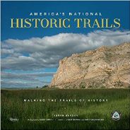
One of the best ways to learn history is to literally follow in the footsteps of those who were there, says Karen Berger, author of the new book, “America’s National Historic Trails.”
“These are historic routes – a trail version of the National Park system,” she says. The 19 federally recognized trails range from 54 to 5,000 miles, and pass largely through rural areas, making them perfect for road trips and socially distant traveling.
A good example is the Selma to Montgomery National Historic Trail. Although the shortest trail at just 54 miles, this route resonates with many travelers, retracing 1965’s famous five-day voting rights march to the Alabama state capitol. The trail crosses the Edmund Pettus Bridge in Selma, where the late Rep. John Lewis and others were beaten by police. Mostly following U.S. Highway 80, the route lets travelers delve into civil rights history at visitors centers, museums and memorials.
Another is the Overmountain Victory National Historic Trail, right here in North Carolina. During the latter half of the Revolutionary War, the British found themselves outmaneuvered and outsmarted by southern mountain men, who won 1780’s decisive Battle of Kings Mountain in South Carolina. The trail traces the route of the American fighters, known as the Overmountain Men.
Occupying a hilly slice of high desert below the east flanks of Mingus Mountain, the new Blowout Wash trail system is shaping up to become a prime Verde Valley hiking destination.
The remediation project is a multi-agency collaboration of local, state and federal land agencies working together to improve recreational opportunities in Prescott National Forest southwest of Cottonwood, AZ.
Trail construction began in 2019. Before that, the wash-riddled foothills surrounded by popular recreation hubs in Sedona, Jerome, Dead Horse Ranch State Park and the Woodchute-Mingus Mountain complex of routes were rife with user-created paths, shooting, and dumping that were disrupting the ecosystems and decimating native vegetation.
The destructive, anything-goes arena is gradually being replaced with sustainable, non-motorized trails that reduce erosion, protect natural assets and promote responsible use.
A map at the trailhead teases with an overview of planned trail development, and a little loop that was completed in early 2020 provides a tasty tidbit of what’s to come.
Trails help keep us happy and healthy. No one wants to stay inside all the time, so we need places to go outside and explore. On trails you can get all your energy out, see cool plants, trees, and wildlife, and spend time with family and friends. It’s important we keep trails nice so everyone can enjoy them for years to come.
Trails are an important resource, but sadly we are increasingly seeing trails abused by littering and vandalism. American Trails has created a packet to teach kids to be great trail stewards so the next generation of trail lovers can help lead the way towards better care for our trails.
This packet is ideal for elementary age children, and will help teach the importance of trails, different kinds of trail users, and concepts such as trail sharing. There are also pages where kids can put into practice what they learned through worksheets, and a certificate of completion at the end.
If you can’t print this packet at home please contact [email protected] and they can send you a copy.
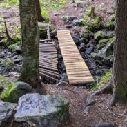
There’s a Maine town trying to identify the hiker who built a replacement bridge next to a collapsed one along a hiking trail on a popular 308-acre preserve. “When outside entities create trails and structures without notifying our department, that leads to confusion for hikers and others” using the Lowell Preserve, Windham town manager Barry Tibbetts posted on Facebook.
The post drew widespread criticism from Mainers who felt the town was targeting the hiker for wrongdoing, instead of thanking them for installing a safe crossing on a municipal trail that had become dangerous. The town’s post was edited the next day to apologize and “thank” the anonymous hiker for making the repairs.
Although its one-person parks and recreation department routinely receives calls about felled trees or animals along the path, Tibbetts said the broken bridge had not been reported to the town, which maintains the preserve with help from partners. The old bridge will be removed and the new one will be “inspected for functionality,” he said.
Tibbetts said that no one had offered information about the hiker yet, but they won’t face repercussions if identified. “If you want to find the person you might try interviewing people picking up litter off the sidewalks, giving lost strangers directions or shoveling the walkways of the elderly,” one commenter suggested.
Two recent deaths on Katahdin, Maine’s tallest mountain, have stirred conversation about hiking safety, raising questions like: “What kind of safety gear should you carry besides water, snacks and a headlamp?”
First of all, accidents happen, and sometimes they’re entirely out of our hands. On occasion, the most prepared hiker can become injured or worse. But there are many ways you can reduce risks while hiking.
Hiking safety is important to think about year round, but some aspects of it become even more important in the fall and winter, when days are shorter and the weather conditions are much harsher.
Before you hit the road — let alone the trail — learn as much as you can about your future hike. Study the trail map and read descriptions of the hike, like those here at Meanderthals. Check the weather report, as well as the time of sunrise and sunset.
Here are a few easy ways you can improve your safety while exploring trails.
In the past, once chilly temperatures and snowy days started to arrive, hikers used to pack up until spring came along. But now that hiking gear is warmer and more weatherproof than ever, they can enjoy the Great Outdoors year-round.
If you plan on immersing yourself in nature this season, there are a few items that you should invest in prior to hitting the trails. In addition to an ultra-warm coat or jacket, you’ll also need to have a top-notch pair of winter hiking boots on hand. The perfect pair will not only keep your feet warm and toasty, but they should also help protect them from the elements.
Nothing can ruin a hike faster than the wrong shoes, so if you’re planning a route through an area that typically has a lot of snow on the ground this time of year, you should opt for a pair of hiking boots that are waterproof to stop the moisture from seeping into your shoe. Meanwhile, those walking through icy terrains should invest in a pair that offers ample traction.
To help you avoid dealing with frozen toes and painful blisters, Travel + Leisure Magazine turned to customer reviews to see which hiking boots they say kept their feet warm, comfortable, and supported through a full day of hiking in snow and slush.
Whether you’re looking for a pair of super warm women’s hiking boots or an ultra-rugged men’s style, these are the 14 pairs of winter hiking boots that shoppers say are the best of the best.
Nancy East and Chris Ford were greeted by an entourage of fans and supporters when they emerged from the woods in the Big Creek section of Great Smoky Mountains National Park, setting a new record for a unique long-distance hiking challenge.
The pair hiked all 900 miles of trails in the park in just 30 days. East, from North Carolina, said she is still getting used to the idea of being a record holder.
“While I’ve hiked thousands of miles, I’ve never hiked this many miles at once. It was immensely rewarding to achieve what I once thought was an insurmountable goal,” East said. “I dreamt and planned on attempting it for so long, and I’m still processing what it feels like to have achieved that goal. But in short, I’m elated and grateful.”
East undertook the extraordinary journey starting on Labor Day weekend with hiking buddy Chris Ford from Tennessee.
Their mission wasn’t just to hike all 900 miles of trail in the Smokies — they’d done that five times between them already. Nor was it to set a new record — although it was a nice capstone.
Their goal was to raise $60,000 in donations for Friends of the Smokies to support the park’s newly launched Preventative Search and Rescue program.
A new hiking challenge called “ADK-9” asks hikers to bring their dogs with them on the outdoor adventure and take a picture of them on the peak.
The ADK-9 hiking challenge provides 9 dog friendly hikes with views and offers a chance to explore lesser traveled peaks of the region.
Once you have hiked all 9 peaks, you are eligible to become an ADK-9 finisher where you will receive a ADK-9 patch, sticker and roster number.
There is also a first-time ever seasonal Fall photography contest where photos of your dogs must be taken on an ADK-9 mountain to be entered.
Photos must be taken from September 15-October 31, 2020. You can submit your photos on Facebook or Instagram by tagging the ADK-9 and using the hashtag #ADK9PhotoContest. Photos can also be submitted through [email protected].
This September, Ireland launched the National Famine Way, which follows the footsteps of 1,490 emigrants who walked from Strokestown, Co Roscommon, to Dublin, hoping to escape the famine. It now doubles as both a live history lesson as well as a hiking and cycling trail.
The trail follows the path of the 1,490 people who left Strokestown and joined ″some of the worst coffin ships” on their way to Liverpool and onward to Quebec, Canada. Only half of those who started the journey ended it alive.
Along the trail, walkers and cyclists can download the OSI Trail Map, which comes with interactive history lessons along the way. There is also a 14-page passport and guide available for €10. The passport comes with 27 stage stamps hikers can collect along the trail. Those who complete the hike and collect all 27 stamps will be awarded a completion certificate at The Irish Emigration Museum.
Walkers/cyclists are also given a ship ticket and information on one family whose footsteps they will follow, making the Trail especially evocative.
Picture, in your mind, an Appalachian Trail (A.T.) view that inspires you. Now have a fellow A.T. hiker do the same. Did the view they selected look anything like yours? Most likely not.
Since the A.T. traverses so many regions, the views along its 2,193 miles vary significantly, sometimes even within a few miles. From craggy mountains in North Georgia, to rolling farmlands in Pennsylvania, to the rugged Saddleback Range in Maine, the Trail provides visitors with a diversity of views to admire, each tied to the environments surrounding the footpath. And while each view may differ in scope and composition, all of them are important to preserving the irreplaceable A.T. experience, and all of them inspire us for a wide variety of reasons.
Yet as inspiring as A.T. views are, it is easy for us to take them for granted. Most of these views have survived for centuries, after all, so many of us don’t stop to consider what it will take to protect them well into the future.
To better address looming threats, the Appalachian Trail Conservancy and the National Park Service (NPS) are taking a vital first step to ensure that they identify and accurately describe the scenic beauty along the A.T. by taking inventory of the current state of the Trail’s irreplaceable views.
Known as the “Enjoy the View” initiative, the ATC and NPS will be collecting data and taking in-depth photographs of over 1,400 viewpoints along the entire A.T. The initiative began in 2019 with an assessment of 70 scenic views at four very different sites along the Trail: Nantahala National Forest in North Carolina, the Virginia “Triple Crown,” South Mountain in Pennsylvania and the Saddleback Range in Maine.
It was well after dark on a recent evening when Philip Carcia, a record-breaking hiker, emerged from another 28-mile day in the woods, his legs streaked with mud and crisscrossed with bloody cuts, into a desolate parking lot near New Hampshire’s border with Maine.
Mr. Carcia, 36, has been living out of his red Toyota Yaris on the outer reaches of the White Mountain National Forest all summer, attempting to break the record on an obscure and extreme hiking challenge known as the Redline: a journey through all 650 trails in a guidebook of the White Mountains, for a total of 2,000 miles and half a million feet of vertical gain.
The trip almost didn’t happen. Like so much else canceled amid the coronavirus pandemic, serious hiking has been in doubt. In the early months of the outbreak, venerable organizations like the Appalachian Mountain Club closed their mountaintop huts, and the Appalachian Trail Conservancy emailed hikers attempting the trek from Georgia to Maine in March and asked them to stay home.
Mr. Carcia watched some of his hiking friends get off the trail. He thought about canceling his trip, but then decided to press on. The intentional isolation of hiking might hold some answers for the forced isolation of the virus.
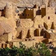
You may find yourself traveling back in time. Hop down a series of stone steps, take a sharp left turn, and feel your heart skip a beat. There, sprawled out below a sandstone plateau dotted with piñon pines and juniper trees, stands the 800-year-old remains of Cliff Palace, an ancient city of the Ancestral Puebloan people.
The largest and best known of Mesa Verde National Park’s native dwellings, Cliff Palace is a wonder to behold. The site contains 150 rooms and 23 kivas (circular ceremonial spaces), indicating that it was once a location of great social and spiritual importance.
Though Colorado’s Mesa Verde may be primarily dedicated to preserving past cultural relics, the park’s use of technology to educate visitors is some of the best in the national park system. There’s a robust mobile app with a full-blown audio tour of more than a dozen sites, a podcast exploring the lives of the Ancestral Pueblo people, and a series of virtual tours of the most famous sites.
As you stare at the vast ruins before you, press play on your phone and find yourself even more deeply transported. The park enlisted TJ Atsye, a ranger and member of the Laguna Pueblo Tribe, to narrate the self-guided driving and walking tour of the Mesa Top Loop Road. She chronicled the history of her ancestors from 600 CE to about 1300 CE, from pit houses to the impressive masonry of the cliff’s-edge villages.
The Triangle Land Conservancy‘s newest nature preserve, the Bailey and Sarah Williamson Preserve, is now open.
The 405-acre property, at 4409 Mial Plantation Rd., Raleigh, offers nine miles of walking and biking trails that connect to the Neuse River Greenway. It’s the eighth nature preserve for the Triangle Land Conservancy, a nonprofit that works to conserve land in North Carolina’s Triangle region.
The Williamson Preserve is the first of the nonprofit’s nature preserves to include working farms on the site. Project Pando is a volunteer-driven farm that grows native trees that will be given to the public for free. The nonprofit also is working with N.C. State’s Center for Environmental Farming Systems to bring other farmers to the preserve. The goal is to give visitors a place to walk or bike and then buy fresh produce.
At the preserve, signage shares the history of the farm, which was owned by the Williamson family for more than 225 years, along with information about the Tuscarora tribe, plantation cotton and tobacco farming, Black rural land ownership and land conservation.
When you’re there, the nonprofit asks that you maintain a social distance from others and avoid overcrowding the parking lot.
As promised yesterday, Meanderthals will shift gears for awhile and introduce you to shared information on the Internet that can help you be a better steward in the outdoors. Today, it’s how to improve your route finding from the REI Co-op.
On many hiking or mountaineering adventures, you’ll leave the well-trodden trail behind to set off for the summit. Doing so is an exciting opportunity to explore new terrain and test your abilities. But to stay on course, travel efficiently and choose a suitable route up the mountain, you and your other group members need to have solid route-finding and navigation skills.
Successful route finding and navigation while hiking and mountaineering combines at-home preparation with on-mountain skills. In this article, we’ll go over ways you can get ready before leaving home and the things you can do while you’re climbing to stay on course.
Good route finding and navigation starts before you set foot on the mountain. In the days and weeks leading up to your trip, spend time brushing up on your navigations skills and pouring over route information so that you can develop a solid mental picture of what the route looks like, including what obstacles, hazards or other challenges you may encounter. Of course, you can’t predict everything that will happen during a trip, but with thorough planning you can eliminate some of the unknowns and increase your odds of having a successful journey.
Akron and the Ohio and Erie Canalway Coalition are moving forward with plans to design the six-mile “Rubber City Heritage Trail” on a stretch of an abandoned elevated rail line.
The trail will be constructed on the former Akron-Barberton Belt elevated railway corridor, and is intended to resemble the High Line in New York City. It will be 10-feet wide and can accommodate hikers and cyclists.
The Rubber City Heritage Trail will serve primarily the residents of Akron by making trail connections to libraries, schools, parks and grocery stores. The trail is being designed in phases as funding becomes available, but the plans call for extending it from the Middlebury neighborhood to the University of Akron, downtown.
The Akron-Barberton Belt railway, or ABB, once served tire and rubber companies in Greater Akron, including Goodyear, BF Goodrich, Firestone and General. The railway has not been in use for more than a decade, and is owned by the city.
In June 2019, hiker Rue McKenrick left his home in Bend, Oregon, and headed into the Three Sisters Wilderness to then walk south along the Pacific Crest Trail. When he hit the end of the Sierras, he turned east, walking across the Mojave Desert in California through Death Valley.
He’s kept walking and, in the last year, has averaged 20 to 30 miles a day, notching more than 8,000 miles total. But McKenrick isn’t on a casual cross-country hike: He’s scouting and mapping the American Perimeter Trail, informally considered the newest and longest hiking route in the country. Conveniently, he also created it.
McKenrick got the idea for the trail a decade ago, after through-hiking the “Triple Crown” of the Appalachian (2,190 miles), Pacific Crest (2,650 miles), and Continental Divide (3,100 miles) Trails. When he couldn’t find any other similar long trails to hike, he sketched out one that connected the Pacific Crest Trail to the Appalachian Trail via the states in between, and the 12,000-mile American Perimeter Trail was born.
Roughly drawn out, the trail circumnavigates the perimeter of the continental United States, but McKenrick is walking both new and existing trails, including parts of the North Country Trail, which runs 4,600 miles from North Dakota to New York; he’s also walking completely undefined areas, where a map, compass, and GPS are required.
 I am Jeff Clark, founder of Internet Brothers, producer of this blog, and passionate about hiking. I live in Western NC near the Blue Ridge and Great Smoky Mountains. Pisgah and Nantahala National Forests are just out my door, so the content will focus on these areas, but let me know what you would like to see on the site.


Copyright © 2011-2023 Internet Brothers. All Rights Reserved. ISSN 2324-6057
Designed by Elegant Themes | Powered by Wordpress | Logo by Design Aspirations