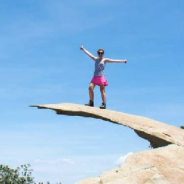
San Diego is known around the country as a beach haven, and for good reason: the county does, after all, have more than 70 miles of pristine, world-class coastline. However, those who actually live in the city know that its natural splendor extends far beyond its shores – the county is also home to some spectacular hiking.
While San Diego’s mountains might not attract the same level of fame as its beaches, they provide a world of opportunity for outdoor enthusiasts looking to hike, mountain bike, climb, or simply get away from the masses, so long as you know where to look.
Lucky for you, there’s a list of the best hikes in San Diego in one comprehensive guide. Strap on your boots and leave the sandals at home – these are the hikes you need to try, ranked on a difficulty scale from 1-10, with one being a simple stroll and 10 being a mountaineering menace. Now go hit the trails.
Spending time with your children is important no matter how old they get, but how can you keep teens and preteens engaged in outdoor recreation during their sometimes rebellious years?
“Kids need to spend time outdoors — a fun, healthy, beyond-the-ordinary place. Backpacking is a great way to help them appreciate all the beauty and adventure that the natural world offers.”
Here are some ways to keep your teens and tweens excited about hiking and backpacking:
Parents can send negative messages when they use too many ‘don’ts’ leading up to a trip.
The more accustomed children get to hiking long distances as a child, the more receiving they will be to it as a teenager.
Teenagers prefer to be with other teenagers. So gather together a group of kids who would make good trail mates — preferably ones with similar ability levels.
Middle schoolers require almost constant fun to stay entertained. Playing games and riddles as you hike, occasional games of hide-and-seek and more can all help your kids stay entertained as you hike.
In the late 1990s, 940 acres on Frenchboro, or roughly two-thirds of the island, was listed for sale. Frenchboro is an island of the coast of Maine, accessible by ferry. Fearing this spectacular property would be purchased for subdivision and seasonal home development, concerned island residents forged a partnership with the Maine Coast Heritage Trust, the Island Institute and the Maine Seacoast Mission to conserve the land. A massive fund-raising effort ensued, and in 2000 the parcel was acquired by MCHT.
In 2011, the entirety of Rich’s Head, 192 acres on the eastern edge of Frenchboro connected by a narrow seawall, was donated to MCHT by David Rockefeller, the noted philanthropist and Mount Desert Island summer denizen. Eleven acres around Little Beach have since been acquired, bringing MCHT’s land holdings on Frenchboro to its present 1,143 acres, and making the conservation project one of the largest the organization has taken on.
There’s not much to Frenchboro, also known as Long Island. A school and a church, and a deli on the opposite side of the harbor. Some 50 people reside year-round on Frenchboro, and most make their living by lobster fishing.
At the edge of the village, a white building houses the library and historical society. A foot trail departs from the left side of the library, and 100 yards into the woods there’s an information kiosk with a trail map. A half-mile beyond is Big Beach, the open ocean, and the start of one mighty fine hiking adventure.
The interior of Frenchboro is a thick forest of spruce and fir, while the coastline is rocky and rugged. A narrow trail threads a path along the margin of woods and water for eight incredible miles you won’t soon forget.
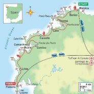
The Lighthouse Way, Camiño dos Faros in Spanish, traverses a stretch of coast that British sailors in the 19th century dubbed the “Costa da Morte” (Coast of Death) because so many of their compatriots died in shipwrecks there. The route goes between Malpica and Fisterra, Spain. Along the way it is marked by haphazardly painted shamrock-green arrows (that often look just like blobs of paint) on trees or rocks.
A group of local friends started piecing the Camiño together in 2013, connecting fishermen’s paths, farm tracks, beaches, livestock trails and the occasional back road. Their goal was to showcase the area’s rugged beauty; they succeeded mightily. A typical day’s scenery includes eucalyptus and pine forests dappled with light; wetlands; fields divided by dry stone walls; wildflowers; small waterfalls; beaches only accessible by foot; small peaks and sand dunes; sandy coves and headlands spilling down to the ocean.
While the Lighthouse Way’s scenery and the hiking are wild, overnight accommodations are not. This is not a backpacking adventure during which you schlep an overstuffed pack and spend nights in a tent. Each day, the Lighthouse Way passes through several villages and towns. You can find your own Airbnb, hotel or inn and hire local taxis to transfer your luggage to the next village or sign up for a self-guided trek that includes all of the reservations and planning, along with GPS tracks and detailed printed topographical maps.
The route rigorously follows the coast and is sometimes so near the edge you can feel spray from waves crashing below. Its name comes from the 11 lighthouses it passes.
Trevor Hahn has been legally blind since he was born. He suffers from macular degeneration, iritis and glaucoma.
“Ten years ago, I could drive a car. Five years ago, it went downhill and I could only see light after that,” Hahn said. “I can only see light now. No shapes, really.”
He learned how to hike using adaptive techniques like following the sound of bells or with voice commands from his hiking partners. That’s how he climbed the 17,575-foot summit of Gokyo Ri mountain in Nepal.
In summer 2018, Hahn and his wife Mandy attended a function with No Barriers USA, a non-profit based in Fort Collins, CO, which helps people with disabilities do adaptive sports and other activities. That’s where they met Melanie Knecht.
“He was telling me just about how he’s been guided up mountains like using a voice system and I’m like, ‘Well, I have a voice,'” Knecht said. Knecht was born with spina bifida. She uses a wheelchair to get around and has never had the ability to walk.
Their friendship blossomed and they came up with an idea they call “Hiking with Sight.”
They got a specially designed harness that Knecht can sit in. Hahn wears the harness like a backpack. It gives Knecht the ability to see over Hahn’s shoulders to guide him on the trail. In return, Hahn carries Knecht to parts of the trail otherwise inaccessible to her. “We both serve a purpose on the trail and a huge responsibility to each other,” Hahn said.
If you’re planning on hiking with your children this summer, it’s important to be prepared. Whether you’re sticking close to home or heading to a national park for a day of fun, follow these safety tips for hiking with children:
If a child becomes lost, teach them these rules:
Hiking with your kids can be great fun. Just be prepared.
Before Jean Taggart left home to conquer the 800-mile Arizona Trail last year, she made a detailed spreadsheet to organize her resupply provisions. To update friends and family on her progress, she bought a Garmin inReach Mini, which is a GPS and satellite messenger. She poured over hiker blogs and absorbed detailed information about each section of the trail on the Arizona Trail Association’s website—which also connected her with “trail angels” who could help her cache water on exceptionally dry sections of the route.
Taggart watched hikers’ YouTube vlogs that detailed nearly every step of the experience, helping her to visualize the unfamiliar trail. And she bought the Guthook Guides’ Arizona Trail app, which loaded her smart phone with detailed trail information, accessible even when she didn’t have cell coverage. She downloaded numerous podcasts and e-books to keep herself entertained during lonely stretches of trail. And she bought a high-powered Anker battery pack to keep her phone juiced up for the days-long stretches between trail towns.
If Taggart—an accomplished Seattle-based hiker who completed the Arizona Trail in November 2018—had undertaken the trail 10 or even five years ago, her experience would have been quite different. When she and her now-husband, Jared Kofron, logged 1,100 miles of northbound hiking on the Pacific Crest Trail in 2014, for example, they used a few trail apps in combination with paper maps. Atlas company Guthook, which came out with its first trail app (for the PCT) in 2012, was still relatively new then. Trail vlogs were less common, and Garmin hadn’t yet released the inReach Mini, a much smaller and lighter version of its previous GPS-enabled trackers. Rewind even further, and hikers taking to any number of long-distance trails hiked without any digital assistance whatsoever.
There’s no doubt that technology has changed the way we hike, as it has all aspects of modern living.
Thru-hiking a National Recreation Trail isn’t easy. Preparing for it is even harder. Backpackers need the right combination of fitness, finances, luck and time. A Pacific Crest thru-hike will set you back about $6,000. Considering the John Muir Trail? Permits are assigned by lottery exactly 168 days in advance. Not to mention the Sierra Nevada snowpack is at roughly 160 percent this year — which is just fantastic after five years of drought, unless your plan was to hike there.
But there is good news for those looking to enjoy the peace of a long hike without the stress of having to negotiate the time, the travel, the gear and bureaucracy. There are more than a thousand other National Recreation Trails in the country — and one of them runs for 32 miles through the San Francisco Bay Area.
The East Bay Skyline National Recreation Trail connects Proctor Staging Area in Castro Valley to Alvarado Park in Richmond, taking hikers through oak savanna, redwood forests and over impressive peaks for sweeping bay views. By joining a series of regional parks and preserves — Anthony Chabot, Redwood Regional, Huckleberry, Sibley Volcanic, Tilden and Wildcat Canyon — the trail offers many of the same features adventurous hikers crave in more remote footpaths, with the bonus of easy parking.
No permits required. No foregoing of personal hygiene necessary. No need to carry 20 kilos of gear, cache supplies, locate safe drinking water or dodge bears. The Skyline is every bit the physical challenge of a longer and more distant trail, but without any of the mental or financial stress. And isn’t that what a walk in nature is supposed to be?
Starting in Apollo Bay and ending at the Twelve Apostles, this coastal trail packs a lifetime of experiences into four to eight days. Trek through Great Otway and Port Campbell National Parks, sharing verdant hills with cows and kangaroos alike. Wind through thick forests and catch a glimpse of a koala clinging to a eucalyptus tree, and marvel at the Southern Ocean in action as it carves out jagged seaside cliffs.
For those who don’t have the luxury of living down under, the Great Ocean Walk (GOW) is the best way to connect with the terrain and wildlife in a short time span. You’ll have the unique opportunity to explore some of the most beautiful places in Victoria rarely seen by the average tourist.
The climate is a bit of a wild card on the aptly named “Shipwreck Coast.” Most people hike between spring and fall, although the summer temperatures can be significant.
Some portions of the trail are impassible at high tide, so stay aware and bring a tide table. There are signs marked “Decision Points” to alert you to areas and beach crossings where you may need to stop and assess the conditions before proceeding. It is not recommended to swim at the unpatrolled and remote beaches along the GOW due to strong riptides as well as limited cell service and rescue vehicle access.
Free guided hikes and other outdoor activities will be offered on public lands across West Virginia on Saturday, June 1, 2019, in recognition of National Trails Day.
Begun in 1993 by the American Hiking Society as a way to introduce people to trails in their area, National Trails Day drew nearly 110,000 people in 50 states to nearly 1,200 hikes and other activities.
This year, National Trails Day events will take place at more than a dozen West Virginia locations, including four in Kanawha State Forest.
Two of the Kanawha State Forest hikes start at 9 a.m., including an easy walk along Spotted Salamander Trail, a wheelchair accessible pathway through a wetland area and along a section of Davis Creek. Carl McLaughlin, historian and hike leader, will recount the role the New Deal’s Civilian Conservation Corps played in creating the state forest.
Other National Trails Day events will take place at:
* Chief Logan State Park: a 2.5-mile walk on Rattlesnake-Coal Mine Trail led by park naturalist Lauren Cole, starting at 9 a.m. from the park’s Activities Building. Participants will receive commemorative patches and certificates.
* Hawks Nest State Park, Ansted: Active Southern West Virginia Community Captain Jacki Wright will lead a 3-mile hike along Cliffside Trail starting from the Midland Trail Picnic Shelter near the lodge, at 10 a.m.
* New River Gorge National River, Kaymoor: A 1.6-mile hike on Butchers Branch Trail led by Active Southern West Virginia volunteers starts at 9 a.m. from the Kaymoor Top parking area off Kaymoor No. 1 Road.
The newest trail in Texas, the Big Bend 100 looks to give the Lone Star State a strong long trail of its own. The brand new route highlights everything the area has to offer with mountain peaks, low lying canyons, sandy desert paths and plenty of desert heat.
When most people think of Texas, they cannot help but imagine flat ranch land, cowboy hats and pickup trucks. It’s fair to say the state is not known as a hiking destination.
The Big Bend area, in far west Texas, combines both the National Park and Texas’ Big Bend Ranch State Park, covering more than one million acres of land with some of the highest mountain peaks in the state. Despite being in the desert, Big Bend National Park is home to bears, mountain lions, and more bird species than any other National Park in the country. The park sits in a county three times the size of Delaware with a population of less than 10,000 people. To the south, the Rio Grande divides Texas and Mexico, and the only wall occasionally dividing the two are the 1,500-foot high rock of Santa Elena Canyon.
Northwest of there and through the town of Lajitas, sits the less-trafficked Big Bend Ranch State Park. Despite getting less attention than the National Park, the Big Bend Ranch State Park has 238 miles of trail, creek crossings, and preserves bits of history in the Lone Star State.
Combining the two created the perfect backdrop for a long trail.
By all accounts, Amanda Eller is an avid hiker. The trail she chose the day she disappeared was one she had hiked before. Eller, a Maui resident who went missing for 16 days before being found, is a fit yoga instructor and physical therapist, yet she still found herself in a life-or-death situation on what was supposed to be a pleasant, three-mile hike.
No one sets out to run into trouble, but even experienced hikers can lose their footing, encounter a threatening wild animal or simply get turned around on the trail. Hiking organizations such as the Appalachian Trail Conservancy, the Pacific Crest Trail Association and the American Hiking Society have must-follow advice for keeping yourself and your hiking partners safe before and during your outdoor adventure.
From hiking boots to SPF, all hiking experts agree that preparing the right equipment is the most important pre-hike step.
A backpack with the essentials — Water and a snack are obvious. Other items to keep in your hiking pack at all times: Sunglasses and sunscreen with an SPF over 30; a headlamp, whistle and lighter are crucial for emergencies; a light waterproof jacket or poncho and one of those silly-looking foil blankets to keep you warm; a knife or multi-tool; a first-aid kit with gauze, tape, scissors and iodine.
A map and a compass — You might think you know the trail like the back of your hand, but accidents happen, and it’s possible for anyone to get turned around or lose the path. If you need to start bushwhacking to get back to civilization, a compass is critical. You can’t always rely on cell service to provide mobile-phone directions.
Going outside inevitably impacts the environment, whether all that remains are your footsteps—as Leave No Trace (LNT) would encourage—or you’re treating nature as your personal trash can and compost pile. And having your period while backpacking or camping only makes it harder to reduce that impact.
In accordance with Leave No Trace principles, don’t leave anything not created by your body—including tampons and toilet paper—in nature. Keep this in mind if you’re going on a trip where you won’t see a garbage can for a while, as you’ll have to carve out space and weight in your pack for used pads and tampons.
As for what you can leave behind, it shouldn’t remain above ground for another person or animal to find. Always dig a six-to-eight-inch-deep hole (LNT calls them catholes) at least 200 feet, or 70 big steps away, from a water source, dump all bodily fluids and the water used to clean your period supplies inside it, and fill it back in.
And don’t just throw period supplies into pit toilets. In comparing rates of decomposition, “the closest thing to a tampon is a disposable diaper, which takes about 450 years,” citing a 2005 study. Even the organic or biodegradable kind still take a long time to break down. So if you leave a tampon or pad in a pit toilet, it could be found by animals. Or rangers would have to remove it, which is extremely difficult.
Jenny Bruso is a 37-year-old, plus-size, queer hiker living in Portland, Ore.
She went on her first hike seven years ago after a person she was dating asked her to join. On the 5.8 mile loop trail she felt self-conscious, walking slowly and sweating because she wasn’t used to working out.
“I really didn’t know what to do except walk,” she said. “But I felt something kind of unlock, this feeling of possibility like I was seeing nature for the first time.”
Ms. Bruso became obsessed with hiking. But the more she hiked, the more she saw that the people on the trails did not resemble her. In 2016, she created an Instagram account, Unlikely Hikers, posting photographs of African-American, gay, transgender and disabled hikers. It has grown ever since.
Ms. Bruso is one of many hikers turning to social media to try to make the outdoors more welcoming and diverse. While Ms. Bruso targets all minorities, other hikers and outdoors groups try to inspire people from specific nationalities, identities or with physical challenges. Many organize real-life events to push their members outside.
Our public lands have a diversity problem. A report released in 2017 by the National Park Service showed that 78 percent of visitors were white. African-Americans, by contrast, represented only 7 percent of visitors.
“Come 2040, our country will have more people of color than white people,” said Ambreen Tariq. “If these people aren’t going into the parks and green spaces, there won’t be anybody to be advocates and stewards,” she said. “We need people to get out there to love the land so they will fight to protect it.”
Alarming headlines about missing hikers, or worse, can trigger panic about trail safety and the risks of exploring remote areas.
The potential for danger exists no matter where you are, but the best way to guard against it is to be prepared and alert.
Here are some tips for how to stay safe while hiking in remote areas, culled from the National Park Service and the Appalachian Trail Conservancy.
Whether you’re alone or in a group, it’s wise to tell someone else where you’re going and when you intend to return. Establish a plan for checking in and follow through with it. If your plans change, let your contacts know.
There’s no harm in bringing your phone (except for taking perilous selfies), but it would a mistake to rely on it for directions. Find a current map and bring along a hard copy of it. Study it and make a plan for where you intend to go. And make sure you know how to orient yourself before you set off.
Places where people congregate – such as roads, shelters and campsites – can carry greater risks of unwanted interactions. Try to make yourself as inconspicuous as possible by camping away from roads and finding a location that’s not clearly visible from a trail.
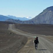
In late 2017, German engineer Jan Dudeck was just completing a decade-long quest to create a new long trail through South America. The Greater Patagonian Trail (GPT), as he named it, would come to be 1,900 miles, stretching through the southern Andes from Santiago to the Argentinean climbing mecca of Mount Fitzroy. “This trail rewards the humble,” Dudeck says, “and humiliates the proud.”
Stories were emerging from some of Dudeck’s collaborators of glacial river crossings, trailblazing, and frontiersman-like bushwhacking on the GPT. These challenges were compounded by the fact that Dudeck’s creation has no trail markers, nor official recognition. It passes through isolated arriero cowboy country and the settlements of indigenous people.
Resupply points are up to 120 miles apart and separated by 10,000-foot mountains. Several sections are reached by culturally sensitive negotiations at restricted access points. Only a trio of adventurers so far have had the sufficient linguistic, logistical, and technical skills necessary to thru-hike Dudeck’s labyrinth.
Dudeck and his Chilean wife, Meylin Ubilla, spent ten years hiking the few established trails in southern Chile and Argentina before beginning to knit together the GPT. Dudeck got the idea for a single trail after returning home from a 2012 horse trek; once back in Europe, he deciphered the route his guides had taken him on using satellite imagery.
“You don’t see it continuously,” he says, “but you see enough to know there should be a connection.” The 12-inch-wide depressions made by the arrieros and Pehuenche people driving animals could be seen in images captured from space. It was a eureka moment, enough for Dudeck to start creating his massive Andean thru-hike.
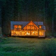
Minam River Lodge is a rare piece of private property within Oregon’s 360,000-acre Eagle Cap Wilderness, which itself is located within the 2.3 million-acre Wallowa-Whitman National Forest. It was founded as a hunting camp in 1950 and even today the only ways to get here are to hike, ride a horse or have local rancher Joe Spence fly you there in his three-seat Cessna 206.
Once at the lodge, which is open from late May into October, there is no cellphone reception, Internet or television; power in the cabins and main lodge comes from an array of solar panels near its organic greenhouse and pigpen.
Eagle Cap Wilderness has 535 miles of trails and 17 peaks taller than 9,000 feet. Much of the Wallowa Mountains, called “the Alps of Oregon” and pronounced WAH-lau-waa, are in the Eagle Cap. Four rivers that run through the wilderness are in the National Wild and Scenic Rivers System, including 39 of the Minam River’s 51 miles.
Ninety-nine percent of guests hike in from the Moss Springs Trailhead, which, at 8 1/2 miles away, is the closest trailhead. But you can also start at the Wallowa Lake Trailhead. This allows you to see dozens of high alpine lakes and some of the range’s tallest peaks, but is substantially longer in time and distance then the trek from Moss Springs.
By pledging to improve a trail you’ll join a nation-wide movement to set a world record and (more importantly) sustain America’s remarkable trails system. With your help, we can preserve beloved trails for future generations. Plus, everyone who commits to improving trails will be entered to win weekly giveaways of awesome outdoor gear.
How does this pledge work?
Make your commitment to improving a trail by simply submitting the online pledge. After National Trails Day®, we’ll ask you how many miles of trail you helped to improve to establish the world record of trail service. Everyone who confirms they improved a trail (of any length) will be entered to win the grand prize package of premium outdoor gear.
How do I improve a trail?
It can be as simple as collecting trash along the trail. Or, take your trail cred to the next level and join an organized trail work party to maintain or build new trail. Check out what trail work projects are in your area. More projects are added frequently leading up to National Trails Day®, so check back if you don’t see a project close to you.
What if I can’t get out on National Trails Day®?
You may take the pledge to improve a trail on another day if you can’t get outside for National Trails Day® but we highly encourage people to join the national movement on June 1st.
How do I share what I did on National Trails Day®?
We’ll be looking for photos and stories tagged with #NationalTrailsDay and @AmericanHiking on Facebook, Twitter, and Instagram.
Still have questions?
Click here for more FAQs or email [email protected].
 I am Jeff Clark, founder of Internet Brothers, producer of this blog, and passionate about hiking. I live in Western NC near the Blue Ridge and Great Smoky Mountains. Pisgah and Nantahala National Forests are just out my door, so the content will focus on these areas, but let me know what you would like to see on the site.


Copyright © 2011-2023 Internet Brothers. All Rights Reserved. ISSN 2324-6057
Designed by Elegant Themes | Powered by Wordpress | Logo by Design Aspirations