There were more than 50,000 wells on state cleanup lists across the country in 2018, and states estimated there were somewhere between 200,000 to 750,000 more abandoned wells that weren’t in their records. If you include wells that are “idle,” meaning they may still have an owner but haven’t produced any oil or gas in years — and are at risk of getting thrust into state hands if their owners go bankrupt — the count reaches around 2.1 million, according to the U.S. Environmental Protection Agency.
When wells are left unsealed, they can become pathways for oil, gas, or briny water to migrate into groundwater and soil. The equipment is a hazard for wildlife, livestock, and unsuspecting humans. But increasing attention is being paid to another risk — an unknown number of unplugged wells leak methane, a powerful greenhouse gas, 86 times more effective at heating up the planet than carbon dioxide over the first 20 years it’s in the atmosphere. At high enough concentrations, methane carries a risk of explosion, and it’s often accompanied by other chemicals that are dangerous to human health, like benzene, a known carcinogen linked to leukemia and low birth weights.
Money is at the heart of the abandoned wells problem. The number of wells has already ballooned far beyond what state budgets and manpower can handle, and experts say it’s on the verge of multiplying.
Nonprofits, founded by oil and gas industry insiders, have formed in recent years with a mission of raising funds to plug derelict oil and gas wells.
On November 3, 2020 about forty people from the USDA Forest Service and The American Chestnut Foundation (TACF) gathered virtually. It was the second biennial plan of work meeting between TACF and SRS.
Since the 1990s, the two organizations have worked together on American chestnut (Castanea dentata) restoration. In 2017 and in 2019, they committed to a Biennial Plan of Work that strengthens the partnership.
At the meeting, foresters, researchers, and organization leaders shared the latest advances in genetics and breeding, restoration research, and disease screening.
Since 1983, TACF has been working to restore the American chestnut. Their science strategy is called 3BUR – a reference to chestnut’s three nutritious nuts in a spiky burr. TACF uses traditional approaches (tree breeding), integrated management approaches (biocontrol), and powerful new molecular tools (biotechnology).
Two major diseases decimated American chestnut: chestnut blight (Cryphonectria parasitica) and Phytophthora root rot (Phytophthora cinnamomi). Chinese chestnut is blight resistant. Chinese chestnut and American chestnut have been backcrossed – a breeding process that aims to recover the timber-type form of American chestnut while keeping Chinese chestnut genes for blight resistance.
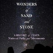
The southern half of Utah is canyon country, a land of aridity, sparse vegetation, and unique and scenically spectacular topography and geology. It is a land rich in sites of archaeological importance and parts of it are sacred to indigenous people. It is also mostly public land, owned by the American people, part of their national legacy, and for a century it has been contested terrain.
Frederick Swanson, in Wonders of Sand and Stone, tells the story of the century-long battles between those who would preserve large parts of this spectacular landscape and those who would dedicate them to “multiple use,” principally grazing, mining, dams, and oil and gas development.
The story begins early in the history of America’s national parks when Utah’s redrock country was virtually inaccessible except to a few intrepid explorers, prospectors, and reaches to the 21st century conflicts over Bears Ears and Grand Staircase-Escalante national monuments.
This century of struggle over public land use has led to five national parks and eight national monuments managed by the National Park Service; the Glen Canyon National Recreation Area, also managed by the Park Service; and the recently diminished Grand Staircase-Escalante and Bears Ears monuments managed, if that is the appropriate verb, by the U.S. Bureau of Land Management.
This week brought with it the announcement of a new national park, one which will eventually encompass 444 acres on the border of Nebraska and Kansas. The governing body setting this new park up isn’t the National Park Service, however; instead, it’s being established by the Iowa Tribe of Kansas and Nebraska.
The Ioway Tribal National Park “will overlook a historic trading village where the Ioway people bartered for buffalo hides and pipestones with other tribes during the 13th to 15th centuries.” When it’s completed, Ioway Tribal National Park will join a growing number of tribal national parks across North America.
It’s worth mentioning here that this isn’t an exclusively American phenomenon. Similar parks have been established in other countries where Indigenous populations faced warfare, oppression and relocation in the name of colonialism. Booderee National Park, located on the east coast of Australia, is owned by the Wreck Bay Aboriginal Community and jointly managed by Parks Australia and the Indigenous community there.
There is another factor in the establishment of tribal national parks: making sure that history is conveyed accurately and that visitors to sacred sites behave appropriately while there. The website for Lake Powell Navajo Tribal Park mentions that several areas within Antelope Canyon can only be visited with a tour guide — something that helps keep the stunning landscapes protected for future generations.
Global warming isn’t the only reason the West is burning. The growing number of people in the woods has increased the likelihood of human-caused ignitions, while more than a century of aggressive fire suppression has contributed to the fires’ severity. In addition, unchecked development in fire-prone areas has resulted in greater loss of life and property.
Yet, it’s impossible to deny the role a warming planet plays in today’s blazes. “Something’s happening to the plumbing of the world,” California Gov. Gavin Newsom said.
You only have to step outside for a moment and feel the scorching heat, witness the dwindling streams, and choke on the omnipresent smoke to know that something’s way off-kilter, climate-wise.
1. Lewistown, Montana, (70 degrees Fahrenheit) and Klamath Falls, Oregon, (65 degrees) set high-temperature records for the month of February.
2. California had its driest February on record.
3. In April, parts of southern Arizona and California saw the mercury climb past 100 degrees Fahrenheit for multiple days in a row, shattering records.
See lots more records like these…
Public lands in Western North Carolina are set to get a chunk of the $9.5 billion approved for deferred maintenance projects with the ratification of the Great American Outdoors Act. The National Park Service and U.S. Forest Service both released project lists last week.
Hailed as the largest single investment in public lands in the nation’s history, the bipartisan act dedicates up to $9.5 billion over five years to address the much larger maintenance backlog on federal lands, as well as $900 million per year to the Land and Water Conservation Fund, which has for the past 50 years protected land for parks, wildlife refuges and recreation nationwide. The law requires that half of the money received from energy development revenues on federal lands and waters go toward these programs, not to exceed $1.9 billion in any fiscal year.
Nationwide, the Forest Service has a deferred maintenance backlog of $5.2 billion, while the Park Service’s stands at $12 billion. As of 2018, the last year for which figures are available, the backlog in the Great Smoky Mountains National Park was worth $235.9 million, and the Blue Ridge Parkway carried a backlog of $508.1 million.
The funds will go to agencies under both the Department of Interior and Department of Agriculture, each of which is handling the process of prioritizing and carrying out the projects in a different way.
Some of the UK’s most breathtaking landscapes will be turned into national parks and Areas of Outstanding Natural Beauty (AONB) to help protect the country’s rich biodiversity, the government has announced.
As part of their 25-year Environment Plan, the project is expected to restore the equivalent of 30,000 football pitches into wildlife-rich habitats, clean up pollution, create areas of woodland, and restore wetland.
While there are currently 15 national parks around the UK — including the South Downs in Sussex, New Forest, Lake District and the Yorkshire Dales — these ambitious plans will see more come to pass over a period of 25 years, giving everyone the chance to soak up nature.
Brilliantly, too, there are also hopes this scheme will help provide shelter for species such as the curlew, nightingale, horseshoe bat, pine marten, red squirrel and wild orchids.
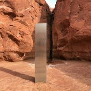
The Utah Department of Public Safety helicopter was assisting Utah Division of Wildlife Resource officers counting bighorn sheep when the crew spotted something mysterious from above.
“One of the biologists is the one who spotted it and we just happened to fly directly over the top of it,” said pilot Bret Hutchings. “He was like, ‘Whoa, whoa, whoa, turn around, turn around!’ And I was like, ‘what.’ And he’s like, ‘There’s this thing back there – we’ve got to go look at it!’”
The crew circled back and landed the helicopter to take a closer look. They couldn’t believe their eyes. Tucked in a red rock cove was a shiny metal monolith protruding from the ground.
“I’d say it’s probably between 10 and 12 feet-high,” Hutchings said. “We were kind of joking around that if one of us suddenly disappears, then the rest of us make a run for it.”
Hutchings said it didn’t look like it was dropped into the ground from above. It was firmly planted there.
That said, the crew decided it didn’t appear there was any scientific purpose to it. Hutchings said it looked as if it was manmade – perhaps more of an art form than any kind of alien lifeform.
Announcing Waterfall Keepers of North Carolina, the only organization dedicated to the state’s resplendent falling water.
Waterfalls are among the few natural wonders that excite all five of our senses at once. We feel the spray against our skin. We hear the calming sound of the falling water. We smell and taste the moisture in the air. And, of course, we see the sublime beauty. Waterfalls give us so much.
Let’s pick up the trash, clear the trails, and protect the plants and animals that live in the waterfall environment. Let’s help make everyone’s visit safe and rewarding. Let’s get the kids involved. Let’s use the healing power of waterfalls to help people who are down.
WKNC has created the perfect way for waterfall lovers to make a difference. Become a Keeper. Keepers pledge to visit “their” waterfall four times a year to pick up trash and report on trail conditions when they visit.
The first annual Waterfall Sweep of North Carolina will be on March 20, 2021. Volunteers will visit waterfalls across the state to clean up litter and perform minor trail maintenance.
Microplastics are one of the most harmful side effects of humans using the planet, and they’re increasingly being found in hard to reach planes.
After being detected in the deepest point on the Earth, the Marina Tech, microplastics have now been found near the Earth’s highest point — the death zone of Mount Everest.
It’s called the ‘death zone’ because that’s where the level of oxygen is insufficient to sustain human life over an extended period. It is defined as any area located over 8,000 meters above sea level. Last year, at least 11 people died in Mount Everest’s death zone within a week when the trail was opened up.
Samples collected from near the summit and the valley below revealed substantial quantities of polyester, acrylic, nylon, and polypropylene fiber — materials commonly used in manufacturing outdoor clothing, tents, and climbing ropes — according to data collected on a Mount Everest expedition consisting of 10 research teams.
Using the same data, another study points out that the glaciers around Mount Everest have thinned by more than 100 meters since the 1960s. More worryingly, the rate of ice mass loss has consistently been getting faster over the last six decades.
Hendersonville, NC-based land conservancy Conserving Carolina has reached an agreement to buy the railroad line from Hendersonville to Brevard, marking a major leap forward in plans for the 19-mile Ecusta Trail.
In a move that was crucial, the Henderson County Board of Commissioners on Wednesday authorized a $7 million bridge loan that will make the sale possible. Conserving Carolina had been negotiating the purchase for months with Kansas-based Watco, the railroad owner that operates shortline freight lines in Western North Carolina as Blue Ridge Southern Railroad.
“This project has been a longterm vision of this board for many years,” John Mitchell, the county’s director of business and community development said. About two years ago, the Board of Commissioners authorized a Greenway Master Plan. “This corridor is owned for the most part fee simple,” making it easier to convey. Watco signaled “a couple of years ago,” he said, that it was willing to sell the line. County officials and the Friends of the Ecusta Trail turned to Conserving Carolina as the buyer.
The announcement of the acquisition of the rail line came 15 months after the state Board of Transportation kicked off a string of good news for the Ecusta Trail. In August 2019 the North Carolina Board of Transportation awarded a $6.4 million grant toward the purchase of the rail corridor. In August of this year, the French Broad MPO awarded $5 million to support construction for the first 5¾ miles of the greenway. The Henderson County Tourism Development Authority has earmarked $500,000 from the county lodging tax to support the trail and the Transylvania County Tourism Board of Directors voted in March to set aside $100,000 for the project.
Clouds are grouped into 10 different genera, organized based on shape and the altitude where they’re found.
The genera names are all formed from the same five latin terms — cirro, cumulo, strato, nimbo, alto — which are mixed and matched to create names like cumulonimbus, cirrostratus, cirrocumuus…. you get the idea. Learning what each of these Latin roots means is key to keeping your clouds straight:
Now that we have the Latin lesson out of the way, let’s explore the 10 cloud genera. There are two ways to group clouds, either by altitude (low, medium, or high) or by shape (layer, heap, layer-heap, rain, wispy).
When President Richard Nixon ‘s signature on the Clean Air Act of 1970 prompted North Carolina to create its Division of Air Quality, air quality was bad in Western North Carolina.
“Back in the ‘80s or the ‘90s, once summer hit your mountains would disappear,” recalled Jim Renfro, longtime air quality specialist for the Great Smoky Mountains National Park. “You’re outside in the valley looking up, and you couldn’t see the mountains through the haze.”
In one of the true environmental success stories of the past century, the situation has improved dramatically since then — and as 2020 fades into 2021, it’s expected to keep getting better.
“Without a doubt we are seeing the lowest ambient air pollution levels that have been recorded since the inception of our program,” said N.C. Division of Air Quality Director Mike Abraczinskas. “That’s wonderful news, testament to all of our good work, advancements in technology, regulatory and non-regulatory measures. North Carolinians are definitely breathing the cleanest air that they have anytime during their lifetimes.”
Data from the early days of the pandemic — March and April — show reductions of about 30 to 50 percent in vehicle miles driven as compared to 2019 figures. For the six-month period ending Sept. 30, 2020 traffic counts at the DAQ’s roadside site in the Research Triangle Park, one of the busiest stretches of road in North Carolina, were down an average of 26.8 percent compared to the same period in 2019, Abraczinskas said.
It appears that this drastic reduction in time on the road is leading to a noticeable improvement in air quality.
Located just north of McClellanville, SC, the 1,450-acre White Oak Atlantic Creosote tract contains an extensive network of dirt roads through some of the most beautiful native longleaf pine woods in the Lowcountry. The property was purchased from White Oak Forestry Corporation — a local corporation that stewards and conserves thousands of acres of significant forest in and around the Santee Delta.
Bordered on three sides by the quarter-million-acre national forest, the property sits across Highway 17 from the 22,000-acre Santee Coastal Reserve and beyond that, the 60,000-acre Cape Romain National Wildlife Refuge. White Oak is the largest acquisition by the Charleston County Greenbelt Program.
The 1,450 acres also represent the biggest private holding left in the Francis Marion and the seventh addition to the national forest by Open Space Institute — which has conserved more than 8,100 acres in and around the forest since completing its first project there in 2014.
The roadways and paths in the tract will make the forest more accessible for hiking, birding and hunting, as well as providing natural habitat for a wide variety of local species.
It’s land that was once part of Peachtree Plantation on the Santee River — owned by Declaration signer Thomas Lynch III and celebrated by poet laureate Archibald Rutledge — that will now belong to the public.
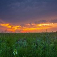
While wooded hikes are popular in Minnesota, the woods are not required, as the tallgrass prairie region in the southwestern corner of the state offers unique places to get out and view the diverse landscape.
Getting lost in the woods while on a walk is a common problem in fairy tales, and in renowned horror stories. Even if you leave bread crumbs behind, in the style of Hansel and Gretel, if you venture off the trail, all of the rocks and trees start to look the same, eventually.
Minnesota is renowned for its big woods hiking, even though roughly one-third of Minnesota is tallgrass prairie, not forests, that dominate the landscape. And when hiking there, one quickly realizes that superlative hiking in Minnesota is not dependent on tree trunks surrounding you and a canopy of leaves or needles overhead.
Much of the swath in the middle of the country collectively known as the Great Plains was covered with a sea of tall grass two centuries ago, before the first Europeans arrived. One of the most onerous tasks the first prairie pioneers faced was breaking up those vast oceans of grass (and their underlying root systems) with their plows so they could grow crops for sustenance and to establish the American agrarian economy.
Like the vast forests of virgin timber that once covered all of northern Minnesota, before the loggers arrived, the uncut tallgrass prairie is all gone. Almost.
Some good news for Alabama’s National Forests. Wild South, the North Carolina based regional forest protection group has announced plans to restructure the organization and form a new independent and separate non-profit organization called Wild Alabama.
As part of the restructuring, the group will keep the entire staff and maintain its current programs and office in Moulton, Alabama, near the Bankhead National Forest. The new Alabama-based group will continue a close sisterhood relationship with Wild South.
Even though it will officially be a new organization in the eyes of the IRS, Wild Alabama has a long storied and successful conservation history in the state.
Originally, the group started off as the Bankhead Monitor in the early 90s. In 1994, they expanded their work statewide and changed their name to Wild Alabama. Eventually, the group became Wild South in the 2000s to reflect their regional efforts. In 2007, they merged with the Southern Appalachian Biodiversity Project, kept the name Wild South and moved its headquarters to Asheville, North Carolina.
The new Wild Alabama’s mission remains the same. They will continue to protect, promote and educate citizens about Alabama’s National Forests and the three Wilderness areas—the Sipsey, Cheaha and Dugger Wilderness areas.
“Innovation” is a fraught concept in climate politics. For years, it was used as a kind of fig leaf to cover for delaying tactics, as though climate progress must wait on some kind of technological breakthrough or miracle. That left climate advocates with an enduring suspicion toward the notion, and hostility toward those championing it.
Lately, though, that has changed. Among people serious about the climate crisis, it is now widely acknowledged that hitting the world’s ambitious emissions targets will require decreasing resource consumption, aggressively deploying existing technologies, and an equally aggressive push to improve those technologies and develop nascent ones.
There is legitimate disagreement about the ratio — about how far and how fast existing, mature technologies can go — but there is virtually no analyst who thinks the current energy innovation system in the US is adequate to decarbonize the country by midcentury. It needs reform.
The International Energy Agency (IEA) concludes that “roughly half of the reductions that the world needs to swiftly achieve net-zero emissions in the coming decades must come from technologies that have not yet reached the market today.” There are reasons to think this might be an overly gloomy assessment, but whether it’s 20 percent or 50 percent, aggressive innovation will be required to pull it off.
Racing to fulfill President Donald Trump’s campaign promises, the Department of Homeland Security is dynamiting cliff sides and carving switchback roads up incredibly steep mountains to build a 30-foot-tall border wall through Guadalupe Canyon. Not only is the construction expensive, it will have little impact on undocumented immigration into the U.S. It will, however, destroy an important North American wildlife corridor.
Diana Hadley, a retired environmental historian, knows firsthand the remoteness of Guadalupe Canyon, a lush riparian corridor spanning northern Mexico and the Southwestern United States. In the early ’70s, she and her then-husband raised three children there while working on a cattle ranch and living off-grid. The canyon walls themselves were “absolutely beautiful,” Hadley said. “They’re really steep, and they’re rosy-colored rock.” Now, some of those rock walls are crumbling.
The canyon is part of the isolated and rugged Peloncillo Mountains, a habitat corridor between northern Mexico and the Southwestern U.S. that is traversed by ocelots, black bears, mountain lions, white-nosed coati and even jaguars — the region is federally designated critical habitat for the endangered cats.
Canyon sections have been designated a wilderness study area by the Bureau of Land Management, and an important bird area by the National Audubon Society. Nearby ranches have conservation easements.
 I am Jeff Clark, founder of Internet Brothers, producer of this blog, and passionate about hiking. I live in Western NC near the Blue Ridge and Great Smoky Mountains. Pisgah and Nantahala National Forests are just out my door, so the content will focus on these areas, but let me know what you would like to see on the site.


Copyright © 2011-2023 Internet Brothers. All Rights Reserved. ISSN 2324-6057
Designed by Elegant Themes | Powered by Wordpress | Logo by Design Aspirations