
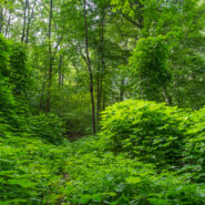
Located in an area of Polk County, NC between Tryon and Saluda, the Norman Wilder Forest is a conservation easement that first opened to the public in 2001. Owned and operated by the Pacolet Area Conservancy, the 185 acres of protected mature third growth mixed hardwood forest provide hikers with a small trail system that meanders beneath the shady canopy. Lying on the...
Learn More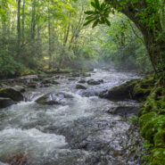
Water. Forest. Mountains. History. For me, that is what Great Smoky Mountains National Park is all about. On the Smokemont Loop hike you will get all of them. For the first couple miles, stroll along one of those beautiful mountain streams the Smokies are known for, then prepare your legs and lungs for a tough climb 1,350 feet through the forest to the top of the ridge....
Learn More
Another foray into the Black Mountains led us to summits with names like Point Misery, Little Butt and Big Butt. The Big Butt Trail takes off from Balsam Gap on the Blue Ridge Parkway along Brush Fence Ridge, roller-coastering across several peaks and gaps. The forest is filled with floral and fungal oddities, and old-growth spruce and pine that protect the ridge like...
Learn More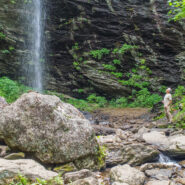
Sometimes you have to work for the reward at the end of the trail. Hiking from Craggy Gardens to Douglas Falls is a prime example. You will descend 1,350 feet from the Blue Ridge Parkway to this 70-foot waterfall through a luscious forest of birch, maple, and beech, even enjoying old growth hemlock along the way. Expect a rough hike, as the terrain is very rugged in the...
Learn More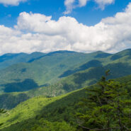
Hiking among the giants of the East. That’s what you’re doing when you take the Blue Ridge Parkway to Mt. Mitchell State Park for this trek on the Mountains to Sea Trail in the Black Mountains. With fabulous views of the Blacks and the Great Craggy Range, and closeup experiences with gnarly old growth fir and spruce krummholz, this stretch of the MtS is some...
Learn More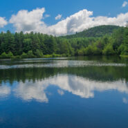
There are 84 named trails in DuPont State Forest. This robust and mature trail system is a series of arteries that connect the various and disparate sections of this family friendly recreation area. In the central region of the state forest I put together a semi-loop hike that took me first to a waterfall, then to a hilltop summit, and finally to the tranquil banks of a...
Learn More
I always enjoy hikes along the South Mills River in the Pisgah Ranger District. This loop follows the north side of the riverbank for several miles along an old logging road. But to get there, first you cross Sharpy Mountain from Turkeypen Gap. The trail travels through beautiful hardwood and heath forest as it roller-coasters across four gaps to its meeting with Wagon...
Learn More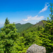
This hike will introduce you to a good cross section of the trails found in Mt. Mitchell State Park high atop the Black Mountains in Western North Carolina. Mt. Mitchell is the highest point in the Eastern United States at 6,684′, in fact six of the 10 highest peaks are found in the Blacks. The climate of the Black Mountains is more like Canada than North Carolina....
Learn More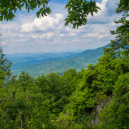
The Cosby area in the Smokies offers quite a few long and rugged hikes from valley floor to mountain tops, including this leg-wrecker from the Cosby Campground to the Appalachian Trail on the Snake Den Ridge Trail. Even up top there are multiple potential destinations. We chose Inadu Knob and the old search & rescue helicopter pad at Deep Creek Gap for the views...
Learn More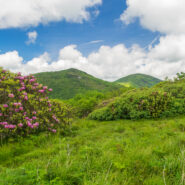
June means catawba rhododendron at Craggy Gardens. Located northeast of Asheville on the Blue Ridge Parkway, Craggy Gardens is loaded with the purple and maroon beauties. There are two short, easy trails near the Visitor Center that access mountaintops for spectacular vista views and bunches and bunches of rhodies. Craggy Pinnacle takes you above 5,800 feet for a view of...
Learn More
Robert “Booger” Palmer may have a silly nickname, but there’s one thing we can always appreciate him for. He never would allow loggers onto his 220 acre homestead in Cataloochee Valley. As a result, still today there is old growth forest that includes poplar trees with trunks six feet in diameter. The massive hemlocks have unfortunately succumbed to the...
Learn More
Little Cataloochee developed as an expansion to Cataloochee Valley with many of the sons and daughters of the original founders spreading their wings, albeit just a few miles away. Travel these days is limited to hiking boots and horseback, but a sense of time and place is still available through the historic restorations made by the National Park Service. Little...
Learn More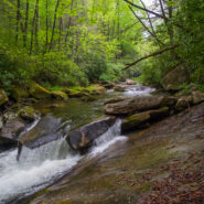
This short, little trail from Cove Creek to the State Fish Hatchery is often overlooked, but it will take you to some of the most gnarly whitewater on Davidson River. The trail is simple. It’s just a straight 1.1 mile shot from one end to the other, and then back. Ah, but have you ever seen a two-tiered trail? If you promise to be very, very careful on the river...
Learn More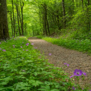
Kephart Prong is one of the many water drainages that give the Smokies its character and provide refreshing nourishment for all the flora and fauna. Named for Horace Kephart, an author who was very instrumental in helping the Great Smoky Mountains achieve national park status, this scenic mountain stream is especially inviting during the spring greening season....
Learn More
Essentially a loop trail (the two ends are about 200 yards apart on Hwy 276), Sycamore Cove is a great hike for the entire family. It’s relatively easy, with only about 600 feet of elevation change, and it’s a delightful four-season hike that is a great way to start your day. The trail initially follows picturesque Starnes Branch amidst large hemlock and...
Learn More
The U.S. Forest Service is the greatest road builder in the world. Oft times, those forest service roads come in handy for hikers to get from one ridge to another, from one creek drainage to another, or simply from one trail to another. That’s the case with Forest Road 225 in Pisgah National Forest. FR225 tips the Caney Bottom and Cove Creek Trails on its eastern...
Learn More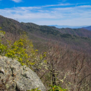
Backcountry wilderness. If you really want to get a taste, then this hike is for you. Starting at the remote Camp Daniel Boone, the northern terminus of the Art Loeb Trail enters Shining Rock Wilderness immediately. As you begin the nearly 2,000′ ascent to Deep Gap, on the southern shoulder of Cold Mountain, you will cross numerous streams as you hike through...
Learn More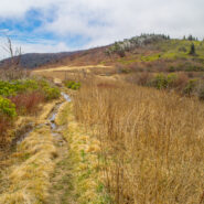
When the Blue Ridge Parkway reopens each year in early spring, it is great to get back into the high country at milepost 420. That means the Black Balsam area and Shining Rock Wilderness. An oft overlooked trail on the west side of the wilderness is Little East Fork, a twisty path that follows the Little East Fork of the Pigeon River from Shining Rock Gap to the Daniel...
Learn More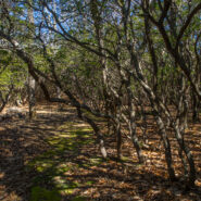
There’s a trail from Scenic Hwy 276 that parallels the Blue Ridge Parkway as it winds around 10 ridges and makes 13 easy stream crossings on its way to the Pisgah Inn on the Parkway. Buck Spring Trail eventually ends up at the site of the former hunting lodge of George W. Vanderbilt II, the father of Pisgah National Forest. In the spring this trail is alive with...
Learn More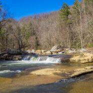
From Saluda, NC the Green River Cove Road drops more than a thousand feet into the Green River Gorge to a meeting alongside the Green River. On the other side of the river is the Green River Cove Trail, at the southern boundary of the Green River Game Lands. The trail starts at Wilderness Cove and follows the river for 4.2 miles to the base of the Green River Narrows, a...
Learn More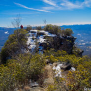
Pinnacle Park is an 1,100 acre tract of land owned by the town of Sylva in Jackson County, NC that was previously used as the community watershed. In 1991 it was leased to the Pinnacle Park Foundation for developing hiking trails that pass by streams, waterfalls, and beautiful long distance vistas. The Pinnacle, where the park got its name, is a large rocky outcropping...
Learn More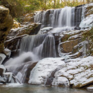
This hike is found in a remote corner of the Green River Game Lands near Saluda, NC that enables you to enjoy beautiful waterfalls. Little Bradley Trail follows Cove Creek along its path to an eventual meeting with Green River, but before it gets there, it tumbles over the three-tiered cascade at Little Bradley Falls. I happened to catch it a couple days after a...
Learn More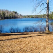
Down in the far southern section of DuPont State Forest is the Reasonover area, near the community of Cedar Mountain. Home to several trails and a couple of reservoirs, like most of DuPont, Reasonover is a great place to go hiking. Especially if you want to stay away from the high country during the winter season, Reasonover is less than 3,000 feet, so you’re a lot...
Learn More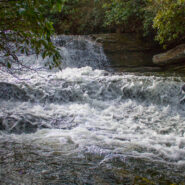
Panthertown Valley in Nantahala National Forest is known for its stunning mountaintop vistas, but also for a numerous and varied assortment of waterfalls that run the gamut from slides, to cascades, to ledge and plunge. Six of those falls are along Greenland Creek, including the feature cascade Greenland Creek Falls. Beyond this tall waterfall, the Greenland Creek Trail...
Learn More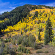
I went to the Colorado Rockies in late September-early October with the expressed intention of being there for the autumnal yellowing of the aspen trees. It’s a gorgeous sight, the leaves take on a golden glow that shimmers in the breeze. Well, mission accomplished. My brother saved East Lake Creek Trail for the last hike of my visit, one that walks for miles in...
Learn More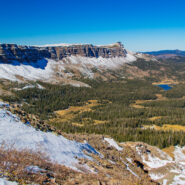
Acrophobia? Then you may want to stay home for this one, or at least don’t go all the way. That was my choice when my life-long fear of heights (that I thought I had conquered) kicked in. Devils Causeway, the destination for this hike on East Fork Trail in Flat Tops Wilderness, is an extremely narrow backbone atop a rocky ridge named the Chinese Wall that drops...
Learn More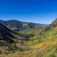
Beginning on Columbine Dr. in East Vail, CO, the Bighorn Trail climbs steeply out of the Vail Valley, then more gradually climbs up through stands of aspen and pine. The trail passes beaver ponds and the remains of old mining camps as well as Bighorn Creek. Near the halfway point, be sure to turn around because the views of Vail and Bighorn drainage behind you are...
Learn More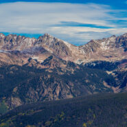
Bowman’s Shortcut is an easy-to-get-to trail that tops a ridge that enables views of three different mountain ranges — Sawatch, Gore, and Tenmile. You’ll start out climbing through a pine forest with occasional glimpses of the distant peaks through the trees, then reach the bald ridge and the magnificent views of some of Colorado’s highest...
Learn More I am Jeff Clark, founder of Internet Brothers, producer of this blog, and passionate about hiking. I live in Western NC near the Blue Ridge and Great Smoky Mountains. Pisgah and Nantahala National Forests are just out my door, so the content will focus on these areas, but let me know what you would like to see on the site.


Copyright © 2011-2023 Internet Brothers. All Rights Reserved. ISSN 2324-6057
Designed by Elegant Themes | Powered by Wordpress | Logo by Design Aspirations