
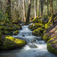
Exactly what the name implies, Big Creek in the Smokies is larger than some rivers in the area. Add in a 70° day after a couple snow events and Big Creek will really roar. When Big Creek roars, that brings out the kayakers, so there was even more of a show than just the scenery. Big Creek Trail is an old logging road that follows the creek westward beneath the...
Learn More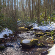
Surrounded on three sides by Cherokee National Forest, Tennessee’s Martha Sundquist State Forest is the only one in the state forest system with a dedicated hiking trail. The Tennessee Gulf Trail (named for a former owner of the property, Lambs Gulf Company) follows Brown Gap Creek from the northwestern to the southeastern corners of this 2,000 acre cove hardwood...
Learn More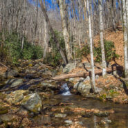
Sometimes the forest roads in national forests make the best hiking trails. Such is the case with FR 5031 in Pisgah National Forest. Located near Courthouse Falls on the far southwestern side of Pisgah, near the boundary with Nantahala National Forest, FR 5031 is a means of getting from a drainage bowl to Farlow Gap on Shuck Ridge. For mountain bikers, you could connect...
Learn More
Even though Devils Elbow is a mountain summit, the highlights of the Devils Elbow Trail in Panthertown are the myriad of waterfalls on the Tuckasegee River. The river forms at the confluence of Panthertown and Greenland Creeks, then takes a wild ride over several falls on its way eventually to Fontana Lake in the Great Smoky Mountains. Most of this hike is on maintained...
Learn More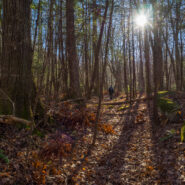
The Greenbrier section of Great Smoky Mountains National Park is filled with old growth forest, and with lots and lots of creeks draining into the valley from the high mountains of the Smokies above. The path of one of those creeks, False Gap Prong, takes it from near Laurel Top to Greenbrier Cove. A non-supported trail — otherwise known as a manway — follows...
Learn More
For a scenic stroll along a horse path through the South Mountains forest, you may give Little River Trail a try. Starting at the Cicero Branch parking area and climbing above Jacob Fork gorge, you will pass viewpoints for the North Carolina Piedmont and follow Little River to the end of the trail at a small but treacherous hidden waterfall. I hiked to Little River Falls...
Learn More
North Carolina’s South Mountains State Park has more than 45 miles of marked trails. No doubt the most popular is the High Shoals Falls Loop Trail, a short, but tough climb to an 80-foot crystal-clear free-fall. Travel for a mile along rocky Jacob Fork River before beginning the steep ascent that requires stairs to navigate the tough terrain. From a viewing...
Learn More
Blue Ridge Pastures is a grassy knoll northwest of Bearwallow Mountain along the Buncombe/Henderson County line. With terrific views of Hickory Nut Gorge, and on clear days The Great Craggy and Black Mountains, the reward for your hard work pays off. The Trombatore Trail will make you climb twice for your reward, once before and once after, but keep that reward in mind...
Learn More
This section of the Palmetto Trail borders the Poinsett Watershed used by the City of Greenville, and roughly follows the North/South Carolina state line. Enjoy a delightful forest hike that winds among the Saluda Mountains as you’re passing through one of the most significant wilderness areas in South Carolina. In 1993, the Greenville Water System conveyed an...
Learn More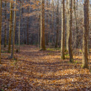
This climb up Station Mountain begins within Oconee Station State Historic Site then passes through Sumter National Forest on the way to Oconee State Park. Along the way you’ll enjoy the 60-foot Station Cove Falls and a botanical preserve inhabited by beaver. The climb is a good workout, as a peaceful hardwood forest and a well-maintained trail lined with switch...
Learn More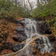
Occasionally a nice easy stroll to a beautiful waterfall is just what the doctor ordered. I made this a three and a half mile loop, but you can actually get to the waterfall in a mile round trip. The woods off FR 475B in Pisgah National Forest are dense and filled with mountain streams running down from the Blue Ridge high above. One of these streams is Log Hollow...
Learn More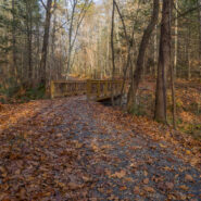
Buffalo Creek Park is the gateway to 1,500 acres of land conserved by the Carolina Mountain Land Conservancy on Weed Patch Mountain that protects the northern headwaters of Lake Lure in Hickory Nut Gorge. The town of Lake Lure has since purchased 200 acres for the creation of Buffalo Creek Park and a network of hiking and mountain biking trails. When fully developed, it...
Learn More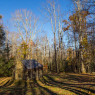
Take a hike on the Maddron Bald Trail from the Cosby area of the Smokies, and you will be thrust into a different age and time. With a restored 19th century cabin and old family cemetery along the way, and mature forest as your destination, you might imagine yourself walking the trail in the days more than a century ago when settlers built their homesteads here. The...
Learn More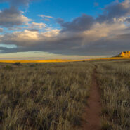
Located on the east side of the Island in the Sky District, Lathrop Canyon drops off the mesa to the White Rim, then dives all the way to the Colorado River. The Lathrop Trail enables a short, medium or long hike, depending on the level of the canyon you wish to tackle. The first couple miles are a sandy straight and level shot through prairie-like grassland. As you...
Learn More
The Needles District forms the southeast corner of Canyonlands National Park and was named for the colorful spires of Cedar Mesa Sandstone that dominate the area. The district’s extensive trail system provides many opportunities for overnight trips or long day hikes including this one around, over and through Elephant Canyon. This 10-mile loop will take you up...
Learn More
The canyon and mesa country north of the San Juan River in the four corners region holds many archaelogical sites where ancestors of today’s Pueblo Indian tribes lived. Round, square, and D-shaped towers grouped at canyon heads most vividly mark once thriving communities. Many dwellings stood right on the canyon rim, and some structures were built atop isolated or...
Learn More
The San Rafael Swell consists of a giant dome-shaped anticline of sandstone, shale, and limestone that houses many of the classic slot canyons that Southern Utah is known for. Included among them is Little Wild Horse Canyon, where the walls are so close you may have to turn sideways to get through. Spring and Fall are ideal times to hike here. The weather is usually dry,...
Learn More
Perhaps the best hike in all of Capitol Reef National Park, Upper Muley Twist Canyon is a full-featured Utah adventure that includes narrow canyons, expanses of slickrock, large arches, and dramatic vistas from the top of the incomparable Waterpocket Fold. There are opportunities for side trips to slot canyons and other exciting off-trail experiences, as well as perilous...
Learn More
Northeast of the Southern Utah town of Kanab, a surprise slot canyon called Lick Wash is located along Skutumpah Road. It’s 15 miles on twisty, dirty ranch road to get there, but the reward is well worth the adventure. This is the Paria-Escalante region of the national monument, beneath the Pink Cliffs. You will even find pink colored stones and pebbles in the...
Learn More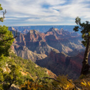
Located on the very southern tip of the Kaibab Plateau, and the prime vista location for the North Rim of Grand Canyon, Bright Angel Point offers a bird’s-eye view of the meeting of Roaring Springs Canyon and Transept Canyon at the Bright Angel Fault. It is 4/10 mile from Grand Canyon Lodge to the point on a paved trail that offers several overlooks along the way....
Learn More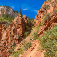
The North Rim of the Grand Canyon doesn’t get nearly the traffic as its more touristy neighbor to the south. For one thing, it is a lot more remote. The North Kaibab Trail is the most difficult of the three trails that dissect the canyon, but it also holds the most varied ecosystem. Somewhat surprisingly, it is forested. With fir and aspen and scrub oak, along with...
Learn More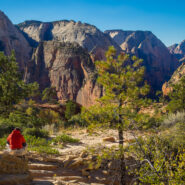
Angels Landing is a unique fin sandstone monolith that erupts 1,500 feet from the floor of Zion Canyon. The trail to the top is one of the most popular hikes in Zion National Park, certainly the most thrilling. For someone like me with heights and edges phobia and vertigo, it’s a little too much excitement, but there is a compromise. You can still enjoy most of the...
Learn More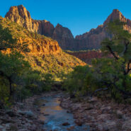
The only trail in Zion National Park that is suitable for wheelchairs, allows your pets to join you, and is also bicycle friendly. Pa’rus is from a Paiute word meaning “bubbling, tumbling water.” Both Oak Creek and Pine Creek cross this paved pathway that winds along the Virgin River between the Visitor Center and Canyon Junction. Ideal for start of day...
Learn More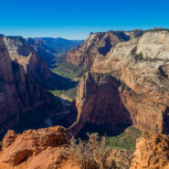
Mount Baldy surveys Zion Canyon at 6,521 feet elevation, more than 2,100 feet above the valley floor. Jutting out from Mt. Baldy into one of the widest sections of Zion Canyon, Observation Point commands a view of nearly every major attraction, particularly those like Angels Landing and The Organ at Big Bend. Hikers receive a spectacular vista of the lower end of Zion...
Learn More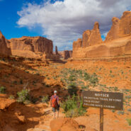
Within Arches National Park you will discover a landscape of contrasting colors, landforms and textures unlike any other in the world. The park has over 2,000 natural stone arches, in addition to hundreds of soaring pinnacles, massive fins and giant balanced rocks. This red rock wonderland will amaze you with its formations, refresh you with its trails, and inspire you...
Learn More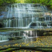
Looking for an easy hike of less than five miles that will take you to several different waterfalls? Yes? Then this just might be the one for you. It starts on the ever popular Cat Gap Trail, passes two falls on Cedar Rock Creek and a whitewater cascade on John Branch before hopping on the Butter Gap Trail to follow Grogan Creek through Picklesimer Fields to the truly...
Learn More
Start your morning with the elk rut in Cataloochee Valley. Then gear up for this enchanting deep forest hike that includes mountain creek crossings, giant old growth tulip poplar and hemlock, occasional views of the Smoky Mountains surrounding the valley, and a stroll down memory lane at historic settler homesteads. Enjoy this 10-mile loop in three segments, on three...
Learn More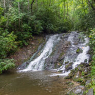
The Deep Creek area in the Smokies, just north of Bryson City, NC, is a water wonderland. Creeks and branches descend through every nook down the surrounding mountains. The documentarian Ken Burns describes Deep Creek as one of his favorite places to visit in the national park. Three picturesque waterfalls are in close proximity to the campground, and hiking trails...
Learn More I am Jeff Clark, founder of Internet Brothers, producer of this blog, and passionate about hiking. I live in Western NC near the Blue Ridge and Great Smoky Mountains. Pisgah and Nantahala National Forests are just out my door, so the content will focus on these areas, but let me know what you would like to see on the site.


Copyright © 2011-2023 Internet Brothers. All Rights Reserved. ISSN 2324-6057
Designed by Elegant Themes | Powered by Wordpress | Logo by Design Aspirations