
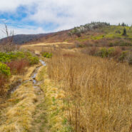
When the Blue Ridge Parkway reopens each year in early spring, it is great to get back into the high country at milepost 420. That means the Black Balsam area and Shining Rock Wilderness. An oft overlooked trail on the west side of the wilderness is Little East Fork, a twisty path that follows the Little East Fork of the Pigeon River from Shining Rock Gap to the Daniel...
Learn More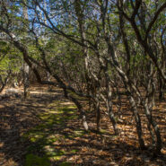
There’s a trail from Scenic Hwy 276 that parallels the Blue Ridge Parkway as it winds around 10 ridges and makes 13 easy stream crossings on its way to the Pisgah Inn on the Parkway. Buck Spring Trail eventually ends up at the site of the former hunting lodge of George W. Vanderbilt II, the father of Pisgah National Forest. In the spring this trail is alive with...
Learn More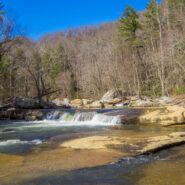
From Saluda, NC the Green River Cove Road drops more than a thousand feet into the Green River Gorge to a meeting alongside the Green River. On the other side of the river is the Green River Cove Trail, at the southern boundary of the Green River Game Lands. The trail starts at Wilderness Cove and follows the river for 4.2 miles to the base of the Green River Narrows, a...
Learn More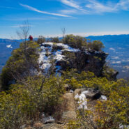
Pinnacle Park is an 1,100 acre tract of land owned by the town of Sylva in Jackson County, NC that was previously used as the community watershed. In 1991 it was leased to the Pinnacle Park Foundation for developing hiking trails that pass by streams, waterfalls, and beautiful long distance vistas. The Pinnacle, where the park got its name, is a large rocky outcropping...
Learn More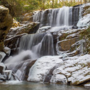
This hike is found in a remote corner of the Green River Game Lands near Saluda, NC that enables you to enjoy beautiful waterfalls. Little Bradley Trail follows Cove Creek along its path to an eventual meeting with Green River, but before it gets there, it tumbles over the three-tiered cascade at Little Bradley Falls. I happened to catch it a couple days after a...
Learn More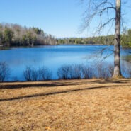
Down in the far southern section of DuPont State Forest is the Reasonover area, near the community of Cedar Mountain. Home to several trails and a couple of reservoirs, like most of DuPont, Reasonover is a great place to go hiking. Especially if you want to stay away from the high country during the winter season, Reasonover is less than 3,000 feet, so you’re a lot...
Learn More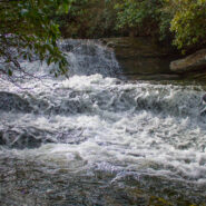
Panthertown Valley in Nantahala National Forest is known for its stunning mountaintop vistas, but also for a numerous and varied assortment of waterfalls that run the gamut from slides, to cascades, to ledge and plunge. Six of those falls are along Greenland Creek, including the feature cascade Greenland Creek Falls. Beyond this tall waterfall, the Greenland Creek Trail...
Learn More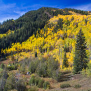
I went to the Colorado Rockies in late September-early October with the expressed intention of being there for the autumnal yellowing of the aspen trees. It’s a gorgeous sight, the leaves take on a golden glow that shimmers in the breeze. Well, mission accomplished. My brother saved East Lake Creek Trail for the last hike of my visit, one that walks for miles in...
Learn More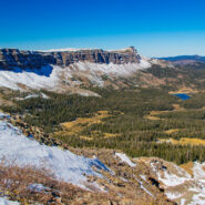
Acrophobia? Then you may want to stay home for this one, or at least don’t go all the way. That was my choice when my life-long fear of heights (that I thought I had conquered) kicked in. Devils Causeway, the destination for this hike on East Fork Trail in Flat Tops Wilderness, is an extremely narrow backbone atop a rocky ridge named the Chinese Wall that drops...
Learn More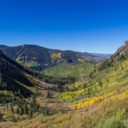
Beginning on Columbine Dr. in East Vail, CO, the Bighorn Trail climbs steeply out of the Vail Valley, then more gradually climbs up through stands of aspen and pine. The trail passes beaver ponds and the remains of old mining camps as well as Bighorn Creek. Near the halfway point, be sure to turn around because the views of Vail and Bighorn drainage behind you are...
Learn More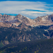
Bowman’s Shortcut is an easy-to-get-to trail that tops a ridge that enables views of three different mountain ranges — Sawatch, Gore, and Tenmile. You’ll start out climbing through a pine forest with occasional glimpses of the distant peaks through the trees, then reach the bald ridge and the magnificent views of some of Colorado’s highest...
Learn More
Booth Lake Trail begins at Booth Falls Road in East Vail, CO and ends at Booth Lake. The trail climbs up the Booth Creek valley through mostly aspen groves before passing the 60-foot Booth Falls. Beyond the falls the trail winds through conifer forests and meadows filled with wildflowers. Above 10,000 feet the trees thin and the terrain changes offering views of the Gore...
Learn More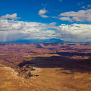
Canyonlands preserves a wilderness of rock at the heart of the Colorado Plateau in Southeastern Utah. Water and gravity, this land’s prime architects, cut flat layers of sedimentary rock into hundreds of canyons, mesas, buttes, fins, arches, and spires. At center stage are two canyons carved by the Green and Colorado rivers. Island in the Sky stands more than two...
Learn More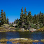
One of the things I miss about the Blue Ridge and Smokies is mountain lakes. The Rocky Mountains are adorned with memorable alpine lakes, usually surrounded by majestic peaks and bountiful evergreen forest. All you need is an input and output source, like Fall Creek in the case of Lake Constantine, and a bowl between mountains to collect the water. Fall Creek Trail...
Learn More
Nestled in the beautiful Blue Ridge mountains near Asheville, North Carolina, YMCA Blue Ridge Assembly is a full-service conference center situated on 1,200 acres of woodland beautified by mountain streams, wildflowers, ridges, valleys and spectacular views. What is little known about the property is the extensive hiking trail system. Primary among these is the High...
Learn More
Carl Sandburg’s wife Lilian discovered the mountain farm named Connemara in the community of Flat Rock, south of Asheville, NC. From 1945, until his death in 1967, the famous American poet, biographer, and Pulitzer Prize-winning author lived and worked on the 264-acre estate. The family then sold the property and donated the contents to the National Park Service...
Learn More
Most people who head out Clingmans Dome Road in Great Smoky Mountains National Park are there to climb the half mile to the summit of the 2nd highest mountain in the East. But here at Meanderthals, we aren’t most people. Below Clingmans Dome are trails that explore the ridges and drainage on the south face. Included among those are Forney Creek Cascade, a classic...
Learn More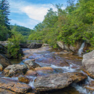
Graveyard Fields is an anomaly — a high mountain meadow and bog surrounded by 6,000 foot mountain peaks. The wide-open spaces found at Graveyard Fields are a rarity, an exception in the otherwise lush and densely forested slopes of Pisgah National Forest and Shining Rock Wilderness. Popular with locals and tourists alike, no trip to the high country of Western...
Learn More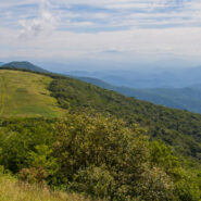
Northeast of Mars Hill, NC, the Big Bald Range straddles the Tennesssee/North Carolina border and marks the boundary between Pisgah and Cherokee National Forests. The Appalachian Trail (AT) follows the state line, as it does for nearly all its length between these two states. The destination for this hike is 5,516 foot Big Bald Mountain, another of the grassy balds that...
Learn More
Peaceful. If I were to think of a single word to describe the Pink Beds Loop Trail, that would be it. Peaceful. Located in a high valley in the Cradle of Forestry, Pink Beds is surrounded by the tall mountains and lush woodlands of Pisgah National Forest. Home to rare mountain bogs, unique vegetation, and unusual wildlife, this area is ideal for those who like to explore...
Learn More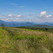
High above the community of Erwin, Tennessee, the Appalachian Trail follows the North Carolina / Tennessee state line through the Unaka Range. From a grassy bald ridge with the appropriate name Beauty Spot, to the summit of 5,184′ Unaka Mountain, the trail winds northeasterly for a 4-mile section through a continuously changing ecology. Stand on the bald with...
Learn More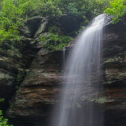
This short hike is family friendly, including even toddlers. The Moore Cove Trail leads you 0.7 mile to Moore Cove Falls, a 50-foot free-fall over a cave-like outcropping. As long as you’re careful, you can get in behind this waterfall and peer at the forest through the cascade. Hey, on a hot day it makes a great refreshing shower. In season, you may discover a...
Learn More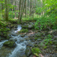
Looking to do some ridge hiking down, down, down from the Blue Ridge Parkway into Pisgah National Forest? Overlooking North Mills River, the Little Pisgah Ridge starts at 4,800′, then drops down into the Big Creek drainage some 2,100 feet below. Catch your views of the mountains on the Parkway before you start because this is a heavily forested hike that instead...
Learn More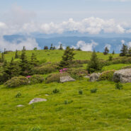
Located along the North Carolina/Tennessee state line, and where Pisgah and Cherokee National Forests merge, Grassy Ridge in the Roan Highlands is the longest stretch of grassy balds in the Appalachian Mountains. The Appalachian Trail navigates this stunning ridge, hopping from Carvers Gap to Round Bald to Jane Bald, and on to the 6,169 foot Grassy Ridge Bald. The...
Learn More
Sometimes even the most benign little trail can be filled with wondrous surprises. Nestled in a small valley between Bryson and Caney Mountains in North Mills River, North Carolina, and surrounded by Pisgah National Forest, the Foster Creek conservation easement and trail is just such a place. Barely a mile in length, and nearly flat, this four-season trail is ideal for...
Learn More
Standing guard along the state line, Max Patch Mountain is a grassy bald with fabulous panoramic views of the surrounding North Carolina and Tennessee Great Smoky Mountains. Oh, and by the way, the celebrated Appalachian Trail crosses its 4,629 foot summit. So far as Southern Appalachian summits go, this one is moderately short and easy, but you can make a day of it by...
Learn More
The Appalachian Trail straddles the Tennessee/North Carolina state line in Great Smoky Mountains National Park for more than 70 miles. A particularly scenic day hike on the AT is the four mile stretch from Newfound Gap to Charlies Bunion, a remote and rugged outcropping that sits on the ridge between the states. Along this sharp ridge you will pass magnificent views of...
Learn More
Hiking a state line offers interesting boundary markers and competing blaze markings. This hike on the Foothills Trail follows the boundary from the highest point in South Carolina — Sassafras Mountain — to a convenient end point at Gum Gap in North Carolina. Because of the length, for us this was a two vehicle hike, with one left at each end. Expect a roller...
Learn More I am Jeff Clark, founder of Internet Brothers, producer of this blog, and passionate about hiking. I live in Western NC near the Blue Ridge and Great Smoky Mountains. Pisgah and Nantahala National Forests are just out my door, so the content will focus on these areas, but let me know what you would like to see on the site.


Copyright © 2011-2023 Internet Brothers. All Rights Reserved. ISSN 2324-6057
Designed by Elegant Themes | Powered by Wordpress | Logo by Design Aspirations