
Arriving before the morning sun had a chance to melt the fresh dusting of snow, I walked this short loop in the southwest corner of DuPont State Forest with the sound of woodpeckers filling the air… and not much else. It was quiet. A half inch of snowfall muted the normal sounds. I purposely picked this woodsy loop. Usually enjoyed by mountain bikers, I guessed...
Learn More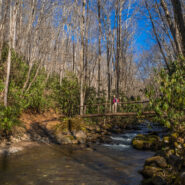
Bryson City, NC is located on the far southern boundary of Great Smoky Mountains National Park and hosts the Deep Creek and Lakeview regions of the park. Noland Creek Trail runs north/south off Lakeview Drive between Fontana Lake and the Noland Divide high above in the mountains. The trailhead is one mile north of the lake and heads in both directions. On this day Ken...
Learn More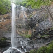
Jones Gap State Park sits on the Blue Ridge Escarpment in upstate South Carolina very near the state line with its neighbor to the north. Along with Caesars Head State Park, these two share an area known as Mountain Bridge Wilderness. The Jones Gap Trail follows the Middle Saluda River along an old roadway built by Solomon Jones in the 1850s. In this cove backcountry the...
Learn More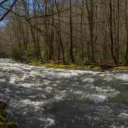
The Smokemont region of the Smokies is one of the most convenient, located just a short few miles northwest of the Oconaluftee Visitor Center off Hwy 441. The trailhead for Bradley Fork starts in the back of the Smokemont Campground, surrounded by the Smokies ubiquitous waterways. It’s only a mile and change up Bradley Fork Trail to its meeting with Chasteen Creek...
Learn More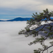
August 2005 saw the Carolina Mountain Land Conservancy and The Nature Conservancy purchase a 1,568-acre tract of land south of Lake Lure known as “World’s Edge” for $16 million with the intention of transferring the land as the first to be added to the new Chimney Rock State Park. World’s Edge contains a mile-long set of steep slopes on the eastern edge...
Learn More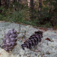
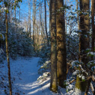
The far southwestern corner of DuPont State Forest offers a forested hike atop multiple plutons, past a retired rock quarry, and across a couple of gentle mountain streams. The oak trees are in abundance, as are white and longleaf pines. Look for the fascinating moss and reindeer lichen on the plutons as you gaze at the far away mountains of Pisgah National Forest. This...
Learn More
Beginning at the Guion Farm area of DuPont State Forest on Sky Valley Road you can make a nice hike on several roads that loop through a deep and dense pine woodland. This is a pine regrowth region that the N.C. Forest Service leases for controlled logging, so you may need to keep your eye out for large trucks, but you may also have the opportunity to see modern...
Learn More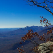
Matthews Creek plunges more than 350 feet over Raven Cliff Falls into the gorge it has carved below Raven Cliff Mountain. One of a myriad of landmarks along the Blue Ridge Escarpment in Caesars Head State Park, the rim of this gorge offers a gentle and rewarding hike. Part of the Mountain Bridge Wilderness Area that also includes Jones Gap State Park, this is the most...
Learn More
Historic Asbury Trail straddles the boundary between the Smokies national park and the Appalachian Ranger District of Pisgah National Forest. It is named for Methodist Bishop Francis Asbury who, in the early 19th century, brought his traveling ministry to this area that would eventually become a national park more than a hundred years later. It was also formerly known as...
Learn More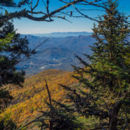
Sometimes things just don’t go exactly as planned. But making the most of what’s available is what sets hiking apart. Everything doesn’t have to go perfectly to still enjoy the day. Such was the case with this hike across the Plott Balsams mountain range from Waterrock Knob on the Blue Ridge Parkway. You’re in rarefied air here, with the entire...
Learn More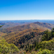
Looking for a short, easy, serene getaway in the high country that offers outstanding long distance views of the Blue Ridge Mountains? This is the trail for you. This little stretch of the famous Mountains to Sea Trail will take you from Black Balsam Road, through a dark and deep balsam spruce forest, across Silvermine Bald and on to Chestnut Bald to a splendid overlook...
Learn More
Located in the far southern region of the Smokies, near Fontana Village and the Little Tennessee River, Twentymile is an area of the national park that is a little less traveled. Primarily used by backpackers as a means of accessing remote park highlights like Gregory Bald or Shuckstack Fire Tower on the Appalachian Trail, Twentymile can also be enjoyed by day hikers or...
Learn More
Leaf peepers head to Graveyard Fields in late September for the annual ritual of Autumn color in the high country. Located at mile 418 on the Blue Ridge Parkway, Graveyard Fields is one of the earliest locations to begin the chromatic display, as well as one of the most intense. From the bright red of the blueberry and sumac bushes, to the multi-colored hues of the maple...
Learn More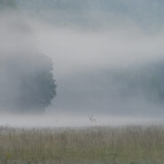
Late September is an exciting time in Cataloochee Valley as the elk herd begins their annual mating dance ritual known as the rut. Cows, calves and yearlings live in loose herds or groups throughout most of the year, and are seen wandering the vast meadows of the valley all spring and summer. The bulls, however, live in bachelor groups or alone. It is rare to happen upon...
Learn More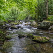
Joyce Kilmer-Slickrock Wilderness straddles the North Carolina / Tennessee line near the southern borders of the states, with about 75% of its 17,000 acres contained in NC. Six trailheads provide access to more than 60 miles of trail within the designated wilderness, which typically follow ridge tops or drop into the shady drainages. Perhaps the most atypical trail...
Learn More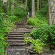
Chimney Tops is one of the more popular destinations in the Smokies because of its central location, rugged beauty, and challenging access. And challenging it is. While short in distance, the trails that lead to the summit of Chimney Tops are steep and strenuous. Accessible from two trails, one below that climbs from Hwy 441 to the top, and one above that drops down from...
Learn More
Grand Highlands is a real estate development in Henderson County, NC. What sets it apart is location. A location that is described as “an open meadow placed on a mountaintop.” Land that affords you some of the most spectacular views in Western North Carolina. I think of it as a picturesque spot for taking photographs of the surrounding Blue Ridge Mountains and valleys....
Learn More
Deep in the remote southwestern corner of North Carolina where the scenic Cherohala Skyway climbs to meet Tennessee at Beech Gap, the Bob Bald Connector Trail (54A) climbs a ridge through Nantahala National Forest to Bob Stratton Bald. One of the lush mountaintop meadows the Southern Appalachians are known for, Bob Bald as it is called, straddles a boundary between...
Learn More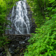
Crabtree Falls is a 70 foot cascade on Big Crabtree Creek, a short hike from the Blue Ridge Parkway. The creek drops over a black rock face with many small ledges, giving it a delicate web-like appearance. A trail descends 500 feet over the course of a mile as it leads to a footbridge crossing the creek at the base of the falls. In the Spring, an impressive array of...
Learn More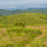
There is a notch between two wildernesses in the Pisgah National Forest high country. Shining Rock Wilderness is to the northeast, and Middle Prong Wilderness is to the west of this pie-shaped cut in the topology. In between are two bald mountaintops that exceed 6,000 feet elevation. To the locals the area is called simply… Black Balsam. The air is fresh (usually),...
Learn More
Deep in the heart of Shining Rock Wilderness is the namesake, a mountain made of quartz, standing more than 6,000 feet. On bright sunny days you can see the white quartz “shining” from miles away. The Cherokee called it Datsu’nălâsgûñ’yĭ, “where their tracks are this way,” that refers to a white rock that is said to have tracks of Tsul...
Learn More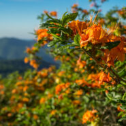
When the Southern Appalachians are your home, the month of June simply isn’t complete without a visit to Roan Highlands for the annual rhododendron and azalea bloom. Like Julie Andrews sang years ago, “these are a few of my favorite things.” From the first time I set foot on Round Bald, I knew this was someplace special. The grassy ridge of the...
Learn More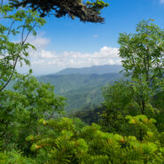
Clingmans Dome is the highest point in Great Smoky Mountains National Park, in the state of Tennessee, and along the Appalachian Trail. Standing 6,643 feet, it is also the third highest peak in the East, only 41 feet lower than the tallest. Several hiking trails surround the summit of Clingmans Dome, including the Forney Ridge Trail that heads south to the picturesque...
Learn More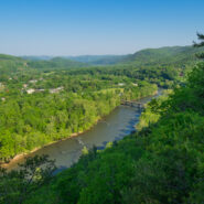
Hot Springs, NC is an Appalachian Trail Community that sits along the French Broad River in the Appalachian Ranger District of Pisgah National Forest. The Appalachian Trail was built through Hot Springs more than seven decades ago, and today white blazes still mark the path through town and over the bridge across the river, before heading north up to the vista, Lover’s...
Learn More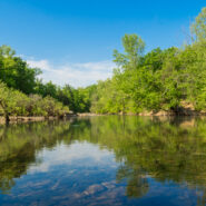
Established in 1972, Buffalo National River flows freely for 135 miles in Arkansas and is one of the few remaining undammed rivers in the lower 48 states. Once you arrive, prepare to journey from running rapids to quiet pools while surrounded by massive bluffs as you cruise through the Ozark Mountains. At a large curve in the river known as Horseshoe Bend, you can access...
Learn More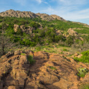
Wild, rugged, and weathered — the Wichita Mountains Wildlife Refuge in central Oklahoma is a symbol of the old west standing at the threshold of modern times. The natural attractions of the refuge are many and varied. In addition to viewing and photographing wildlife in their natural setting, visitors find the lakes, streams, canyons, mountains and grasslands ideal...
Learn More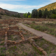
The Puebloan people have lived in the American Southwest for many centuries. Archaeologists think they are descended from groups of hunters and gatherers who came to the region over 10,000 years ago. In the area that is now Bandelier National Monument, in Northern New Mexico, the villages of Tyuonyi and Tsankawi and their adjacent cliff dwellings appeared in the 13th...
Learn More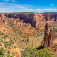
The labyrinth called Canyon de Chelly (pronounced d’SHAY) comprises several canyons that include Canyon de Chelly, Monument Canyon and Canyon del Muerto. At the mouth of the canyons near the tribal town of Chinle, in northeastern Arizona, the rock walls are only 30 feet high. Deeper in, the bright red sandstone bluffs rise dramatically to stand more than a thousand...
Learn More I am Jeff Clark, founder of Internet Brothers, producer of this blog, and passionate about hiking. I live in Western NC near the Blue Ridge and Great Smoky Mountains. Pisgah and Nantahala National Forests are just out my door, so the content will focus on these areas, but let me know what you would like to see on the site.


Copyright © 2011-2023 Internet Brothers. All Rights Reserved. ISSN 2324-6057
Designed by Elegant Themes | Powered by Wordpress | Logo by Design Aspirations