
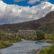
The Río Grande del Norte National Monument is comprised of rugged, wide open plains at an average elevation of 7,000 feet, dotted by volcanic cones, and cut by steep canyons with rivers tucked away in their depths. The Río Grande River carves an 800 foot deep gorge through layers of volcanic basalt flows and ash. Among the volcanic cones in the Monument, Ute Mountain is...
Learn More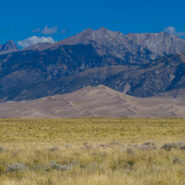
Great Sand Dunes National Park and Preserve protects the tallest sand dunes in North America, and a whole lot more. From the San Luis Valley floor to the crest of the 13,000 foot peaks in the Sangre de Cristo Mountains — the park and preserve contains ecosystems ranging from sand sheet to dunes to tundra — each supporting specially adapted plant, animal and...
Learn More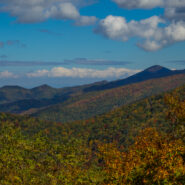
There aren’t many places in Western North Carolina better for Autumn leaf peeping than the Blue Ridge Parkway. On Monday, October 17, 2016 I set out to demonstrate that by taking a little tour between mileposts 410 and 420. But first I had to get there. I went up the Pisgah Ridge on Scenic Hwy 276, passing the Cradle of Forestry along the way. I arrived at the Cold...
Learn More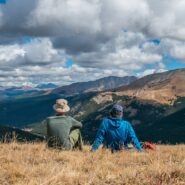
There’s a reason they call it Summit County. An old mining road climbs from Hoosier Pass above 12,000 feet and is surrounded by several of Colorado’s famous fourteeners. The first half of the road meanders through a spruce and fir forest with occasional views of the massive mountains that envelop the region. The rest of the way is above treeline, offering...
Learn More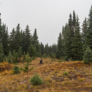
Fog and low-lying mist is very common in the Southern Appalachians. It is a product of the rainforest effect. Fog is highly unusual in the Rocky Mountains, but that’s what greeted Dave and I as we hit the trailhead to climb Shrine Ridge. It was somewhat of a dreary, forlorn scene as we walked from mountain bog to spruce forest to high meadow on our way to the...
Learn More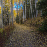
The U.S. Forest Service has done a nice job of building trails up the watersheds that drain into the Town of Vail. Included among these is Spraddle Creek, located across I-70 from Vail Village. The reward at the top of the ridge is a mountain meadow that overlooks Vail, Beaver Creek ski mountain, and the Holy Cross Wilderness far, far away. Hike in late September for an...
Learn More
This remote corner of the Smokies isn’t easy to get to, but your efforts will be rewarded with solitude, quiet, peaceful 2nd growth forest, and a pensive wandering. The Cherokee lived on one side of the ridge. The Cataloochee settlers on the other. They met in the middle to graze their cattle on “The Ledge” between the two. The bald knobs are reforested...
Learn More
The forest north of Cataloochee Valley in the Mt. Sterling watershed has recovered nicely from logging activities a century ago. It is dense, rich and diverse… a verdant testimony to Nature’s ability to reinvigorate herself. This hike starts at the north end of Little Cataloochee on Mt. Sterling Road and meets Long Bunk Trail a mile later. Long Bunk is a near...
Learn More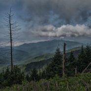
Eastern Tennessee and Western North Carolina can get pretty warm and muggy in mid-summer. Great Smoky Mountains National Park is not exempt from that. So when I hike in July and August I like to head for the high country… and there’s nowhere higher in the Smokies than Clingmans Dome. In fact, it’s the third highest peak in the East and the highest point...
Learn More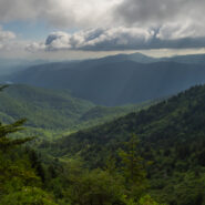
Love the high country in summer. It’s like getting an extra month of spring. For much of its length through the Western North Carolina mountains, the Mountains to Sea Trail parallels the Blue Ridge Parkway. There is an area near mile marker 434 on the Parkway, beneath Old Bald, where the MST winds through mixed forest and high mountain meadows teeming with...
Learn More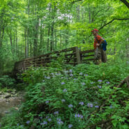
The Little River headwaters region of the Smokies was heavily logged in the early 20th century. As a result, a community called Elkmont sprung up in the valley below to support the lumberjacks and their families. Elkmont eventually became a mountain resort for the well-to-do of eastern Tennessee with its rustic cabins along the river. These days those quaint cottages...
Learn More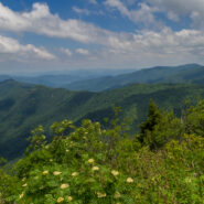
The summer solstice occurs when a planet’s rotational axis, in either northern or southern hemispheres, is most inclined toward the Sun. Most cultures have marked this occasion in some ritualized manner and from time immemorial people have acknowledged the rising of the sun on the summer solstice. At Stonehenge, the heelstone marks the midsummer sunrise as seen...
Learn More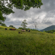
I have hiked to Hemphill Bald from the east along the Cataloochee Divide many times. However, this was the first time approaching from the west on the Hemphill Bald Trail from Polls Gap. This made my second foray into the Heintooga region of the Smokies in recent weeks, another beautiful piece of the national park that doesn’t get enough attention. This trail would...
Learn More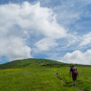
You can see them from Roan Highlands. They appear when viewed from Linville Gorge and Grandfather Mountain too. The long, green balds that comprise Little Hump and Big Hump Mountains stick out like limes in a grapefruit basket. And, you can see all those other landmarks from the Hump Mountains. The iconic Appalachian Trail (AT) arrives from the Highlands of Roan to...
Learn More
This delightful forested trail in the Heintooga section of the Smokies follows Bunches and Flat Creeks up Overlook Ridge to a perch high above Cataloochee Valley and Cherokee, NC. Few short trails in the Smokies are as memorable. The pathway is carpeted with a charming wispy grass that waves in the breeze and tickles your legs as you pass by. What’s not to love? My...
Learn More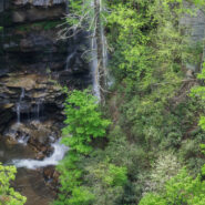
Like its partner, Little Bradley Falls, this hike is found in a remote corner of the Green River Game Lands near Saluda, NC that enables you to enjoy beautiful waterfalls. Big Bradley Trail follows Cove Creek along its path to an eventual meeting with Green River, but before it gets there, it free-falls 75 feet over the stone precipice at Big Bradley Falls. Bring your...
Learn More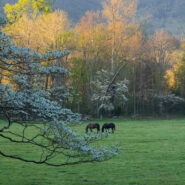
Perhaps the most popular feature in all of Great Smoky Mountains National Park, Cades Cove is a throwback to 19th century living. Think of it as an outdoor museum. Cades Cove is a wide, verdant valley surrounded by mountains that today is teeming with wildlife and spring floral beauty. The 11-mile Loop Road around the valley provides an opportunity for motorists,...
Learn More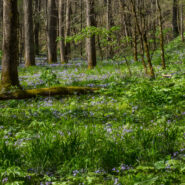
Without a doubt one of the most popular wildflower hikes on the Tennessee side of Great Smoky Mountains National Park, Whiteoak Sink is a basin surrounded by steep hills. In April each year this natural botanical garden comes alive with more than 30 varieties of native wildflowers right alongside the trail for all to enjoy. The name “Sink” comes from the...
Learn More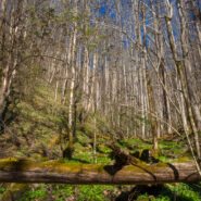
This lovely wildflower trail is about half way up Newfound Gap Road from the Oconaluftee Visitor Center, but its shortish length and tranquil setting belie the grueling terrain. Climbing from the Oconaluftee River valley to Thomas Divide, 2,200 feet above, it is a true test of stamina for even the most seasoned hikers. Kanati Fork is one of those picturesque drainages...
Learn More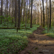
The Smokies can always be counted on for fulfilling the promise of spring renewal. One of the best spots for finding early blooms of exotic native wildflowers is on Porters Creek Trail in the Greenbrier section of the national park. Along the pathway is a diverse array of flowery goodness including the multi-acre mystical fringed phacelia garden, seemingly home to a host...
Learn More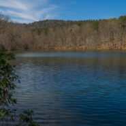
Named for an opportunistic traitor who supported the Crown during the Revolutionary War, Paris Mountain State Park was constructed by the Civilian Conservation Corps during the Great Depression. Richard Pearis owned 150,000 acres including what is now Greenville, SC and this state park north of the city. Once no more than a rural retreat, Paris Mountain is now a bustling...
Learn More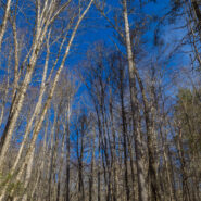
What is the first thing that comes to your mind when you think of the Smokies? Is it 6,000 foot mountaintop vistas that expand the imagination? Perhaps you think of the half-million acres of forest or the hundreds of varieties of wildflowers. There is one other constant in Great Smoky Mountains National Park, and that is water. Cataloochee Valley is surrounded on all...
Learn More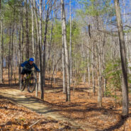
When you step on a trail at DuPont State Forest, you can usually tell pretty quickly if it was designed and built for mountain biking. Some tell-tale signs are banked curves and bumps, rails for tricks, and a smooth, hard-packed surface. Such is the case with Ridgeline Trail. DuPont State Forest is a haven for mountain bikers from all over the Southeastern United States,...
Learn More
The Appalachian Trail splits the states of North Carolina and Tennessee through most of the breadth of Great Smoky Mountains National Park. Hugging the state line as it traverses the rugged and remote ridges, the AT is a favorite destination for day hikers and thru hikers alike. There is a three and a half mile stretch from Newfound Gap to the summit of Mt. Kephart, and...
Learn More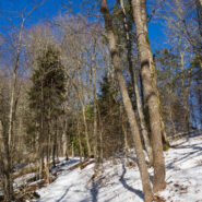
Thomas Divide is one of those ridge hikes that splits the heart of the Great Smoky Mountains Range. It is also one of the longer trails in the national park at near 14 miles, but you can do as much or as little as you wish for a day hike. The trail passes through a rich forest of Eastern hemlock, beech, birch and multiple varieties of maple. The crest also enjoys the...
Learn More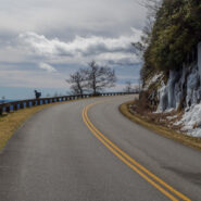
Walking the Blue Ridge Parkway in winter is a great way to get a slow-motion view of the wonderful vistas that whiz by at 45 mph in your car. The Parkway is closed so you don’t have to worry about traffic. The only concern really is perhaps slipping on snow or ice. This latest in the Photo Essay series looks at a 4-mile stretch of the BRP between mileposts 412 and...
Learn More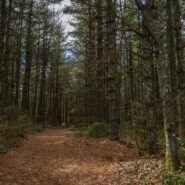
Working on a little project to tick off all the trails within DuPont State Forest, I visited two short ones that are close to each other in the northeast corner off Sky Valley Road. Each is little more than a mile round trip. Flat Rock Trail passes through a boulder field and past a recent logging operation to a dead end at the confluence of Jim Creek with Grassy Creek....
Learn More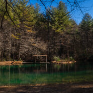
Located in the heart of DuPont State Forest, Three Lakes Trail does exactly what its name implies… it takes you to a trio of very picturesque lakes near Conservation Road. Lake Dense is an ideal stop for a family picnic. Lake Alford, really more of a pond, may be the most vivid and charming of all. The largest, Lake Julia, is breathtaking from every angle. Add to...
Learn More I am Jeff Clark, founder of Internet Brothers, producer of this blog, and passionate about hiking. I live in Western NC near the Blue Ridge and Great Smoky Mountains. Pisgah and Nantahala National Forests are just out my door, so the content will focus on these areas, but let me know what you would like to see on the site.


Copyright © 2011-2023 Internet Brothers. All Rights Reserved. ISSN 2324-6057
Designed by Elegant Themes | Powered by Wordpress | Logo by Design Aspirations