
Jones Gap State Park sits on the Blue Ridge Escarpment in upstate South Carolina very near the state line with its neighbor to the north. Along with Caesars Head State Park, these two share an area known as Mountain Bridge Wilderness. The Jones Gap Trail follows the Middle Saluda River from the park visitor center along an old roadway built by Solomon Jones in the 1850s. In this cove backcountry the river is quite wild with many waterfalls and rapids that add exciting sights and sounds to a pristine mountain woodland. A couple miles up from the eastern end of Jones Gap Trail is Jones Gap Falls, the destination for this hike. My brother Dave and I visited Jones Gap on February 17, 2020 beginning at 10:15am and finishing at 1:15pm. The plan was to take Jones Gap Trail up the Middle Saluda River to Jones Gap Falls and beyond, then return.
Hike Length: 5 miles Hike Duration: 3 hours
Hike Configuration: Up and back Blaze: Blue
Hike Rating: Easy. Navigating the rocks is the most difficult part.
Elevation Change: 480 feet Elevation Start: 1,330 feet
Trail Condition: Poor. Heavy rainy seasons and uncontrolled drainage have led to significant trail erosion. Most of the trail is full of rocks.
Starting Point: Visitor Center parking area at Jones Gap State Park, SC.
Trail Traffic: We encountered about 20 other hikers on this President’s Day holiday.
How to Get There: From SC take Hwy 11 (Camp Creek Road) to River Falls Road and follow the signs to Jones Gap State Park. From NC take Hwy 25 to Gap Creek Road. It’s 6 miles to River Falls Road, then follow the signs to Jones Gap.
South Carolina State Parks have a voluntary $6 hiking fee, so be sure to register either at the Visitor Center or at the sign box in the parking area. It really helps with trail maintenance, something that has become an issue at Jones Gap because of incessant rain for years now.
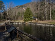
It’s about a quarter mile stroll from the parking area at Jones Gap State Park — along the Middle Saluda River, past the Learning Center — to the eastern Jones Gap trailhead. This trail is also known as the Middle Saluda Passage of the Palmetto Trail (learn more about the Palmetto Trail here and here).
This area of Jones Gap is also an Audobon bird sanctuary and you may be fortunate enough to see a few Great Blue Herons. They tend to hang out along the river near the Visitor Center. On our earlier visit we stopped at the Learning Center and spent nearly a half hour with the park ranger talking about the history and geology of the Jones Gap area. Ranger Lee was extremely informative, and a very nice guy to boot.
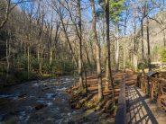
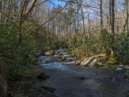
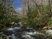
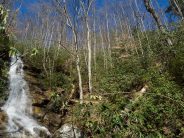
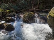
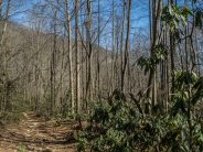
Beyond the Learning Center, a foot bridge takes you across the river, past a signboard detailing all the trails in Mountain Bridge Wilderness, and onto the Jones Gap Trail. The blue-blazed trail is slightly uphill as it follows the whitewater of the wild river. When we were here a few years ago, this major trail artery up the gap was in excellent condition, perhaps a little rocky, but otherwise well taken care of. That is not the case now. Rain, year after year, has turned this trail into a sub-drainage of the river, and with it all the mud and erosion that would be expected. Unfortunately, it will be very expensive to repair the drainage problem.
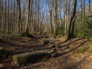
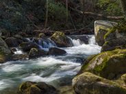
There are 4-5 campsites alongside the trail and the river that make excellent vantage points for views upstream. During the green and warmer months, these sites are usually occupied, so you don’t want to infringe on their privacy. But off season, they’re good for photos of the river, and perhaps for a snack break.

An example view from one of the trailside campsites.
A little less than a mile upriver, look for red blazes bearing right onto the Rainbow Falls Trail. The Jones Gap Trail continues to the left at the junction and Rainbow Falls bears to the right. Here is the trail report, if you’re curious. But for this hike, take the left fork, blue blaze.
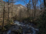
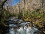
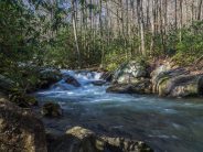
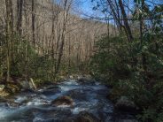
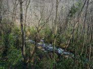
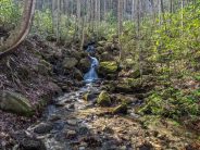
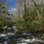
It is approximately another three-quarters mile from this junction to Jones Gap Falls. The trail gets decidedly steeper, climbing a few hundred feet. When you cross the river to a campground on the north side, you are almost there. Look for several nice cascades along this stretch.
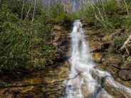
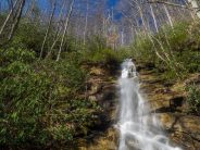
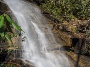
You’re nearly there now. When you reach the trail sign for the falls, head uphill away from the river. It isn’t far, perhaps 70 yards. Once you clear the first rise you will know you’re there. This is a large waterfall — 50 feet in height, probably 15-20 feet wide. Because of heavy winter rain, it was flowing pretty good. Both sides of the falls are surrounded by extremely thick rhododendron. I suspect this area is a chromatic delight during bloom season.
There are some flat rocks at the base of the falls that are perfect for lunch. They are just far enough away from the falls that we didn’t get mist in the face as we put on the feed bag. We stayed for nearly a half hour for pictures, and simply to enjoy this appealing waterfall.
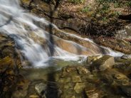
After getting renourished, we still had some energy, so we continued up Jones Gap Trail. You can go another four miles to the western end of Jones Gap. Here’s the trail report. But we weren’t that adventurous. We went up another quarter mile or so, found a nice cascade along the river, and discovered what I call Smiley Rock. See the photos below.
From Jones Gap Falls, the return to the Visitor Center is just a straight shot back down Jones Gap the way you came.
Summarizing, unfortunately the condition of the Jones Gap Trail has really deteriorated since my initial visit in 2012. It’s a shame too. The SC State Parks folks had done a wonderful job building it. It is certainly still passable. Just plan on getting your hiking boots muddy, and be very careful where you step. Very easy to turn an ankle, or worse. The waterfall is quite nice, well worth the effort to get there. This is one the entire family can enjoy, as long as you have appropriate footwear.


The following are paid links. As an Amazon Associate I earn from qualifying purchases.
 I am Jeff Clark, founder of Internet Brothers, producer of this blog, and passionate about hiking. I live in Western NC near the Blue Ridge and Great Smoky Mountains. Pisgah and Nantahala National Forests are just out my door, so the content will focus on these areas, but let me know what you would like to see on the site.


Copyright © 2011-2023 Internet Brothers. All Rights Reserved. ISSN 2324-6057
Designed by Elegant Themes | Powered by Wordpress | Logo by Design Aspirations