
August 2005 saw the Carolina Mountain Land Conservancy (now Conserving Carolina) and The Nature Conservancy purchase a 1,568-acre tract of land south of Lake Lure known as “World’s Edge” for $16 million with the intention of transferring the land as the first to be added to the new Chimney Rock State Park. World’s Edge contains a mile-long set of steep slopes on the eastern edge of the Blue Ridge Escarpment, with more than 20,000 feet of streams and waterfalls.
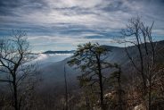
From an overlook point, the land falls away to the southeast providing a stunning view of North Carolina’s Piedmont. On the northwest side, the area provides habitat for rare flowers, diverse forest communities, endangered bats and salamanders, unique cave-dwelling invertebrates, and birds such as peregrine falcons and migratory neo-tropical species. Transfer of the World’s Edge tract to state ownership was completed in 2006.
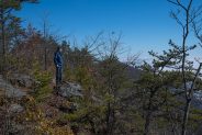
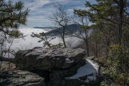
Primitive trails hug the rugged landscape, offering a view of things to come for the courageous souls willing to get a scrape or two and bushwhack the craggy rim. The state park’s master plan mentions further trail development and visitor amenities on this corner of the property, including permanent overlooks, backcountry campsites, and a day use area. However, with funds being tight in state government, don’t look for any of this to occur in the near term.
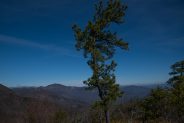
In the mean time, you can access World’s Edge from Edneyville, NC via Gilliam Mountain Rd. and Sugarloaf Mountain Rd. to Ottanola Gap. There is limited parking in the cul-de-sac at the gap. Please don’t block access to the private drive that is also there. You can follow the old 4wd road to the first overlook and beyond. For an easy 2-mile out and back hike, continue to follow the road, with stops at each of the 3-4 overlooks along the way. You drop approximately 200 feet of elevation on the way out.
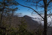
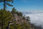
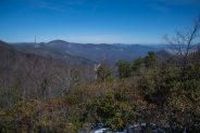
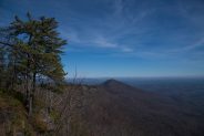
For the more adventurous among you, there is a very primitive game trail from the first overlook that follows the extreme edge of the rim as far as Chinquapin Gap. Be warned that there is exposure of falling from rock outcrops along the rim, and that some bushwhacking will be required. Otherwise, this trail offers the best views of both sides of the rim, including Sugarloaf and Chimney Rock Mountains to the west, and the Pool Creek drainage into Lake Lure Village.
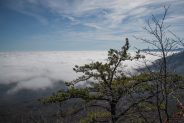
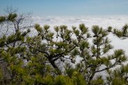
With the photo gallery below, I hope to portray a pictorial essay of what NC residents and tourists have to look forward to in the coming years as the World’s Edge tract is developed for state park access. There is a grand plan for all of the magnificent Hickory Nut Gorge that may take a couple of decades to achieve fruition, but when it is complete this area will rival anywhere in the country for recreational opportunity and breathtaking scenery.
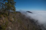
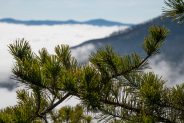
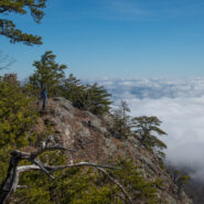
My brother Dave and I visited on February 9, 2020 and were treated to a cloud inversion on the east side of the World’s Edge rim.


The following are paid links. As an Amazon Associate I earn from qualifying purchases.
 I am Jeff Clark, founder of Internet Brothers, producer of this blog, and passionate about hiking. I live in Western NC near the Blue Ridge and Great Smoky Mountains. Pisgah and Nantahala National Forests are just out my door, so the content will focus on these areas, but let me know what you would like to see on the site.


Copyright © 2011-2023 Internet Brothers. All Rights Reserved. ISSN 2324-6057
Designed by Elegant Themes | Powered by Wordpress | Logo by Design Aspirations