
Another of the fun and exciting South Carolina state parks that line the Cherokee Foothills Scenic Highway, Keowee Toxaway offers two hiking trails that take visitors over a natural bridge and through the foothills of the Blue Ridge Mountains, land once traveled by Cherokee Indians. Much of the trail follows the shore of Lake Keowee through the healthy oak/hickory forest that surrounds it. The trail’s namesakes are interesting features, but the highlights of this hike are the terrain and the views. I hiked Natural Bridge and Raven Rock Trails on Wednesday, December 6, 2017 beginning at 9:15AM and ending about 12:20PM. My plan was to hike this double loop on the eastern side outbound, then return on the west.
Hike Length: 5 miles Hike Duration: 3 hours
Hike Rating: Moderate. Much of this hike is up and down hills, but none is overly strenuous.
Hike Configuration: Double loops Blaze: White with text
Elevation Change: 406 feet Gain: 794 feet Elevation Start: 1,080 feet
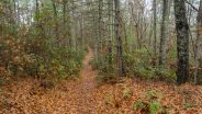
Trail Condition: Very good. Clean, well-marked, packed clay tread with minimal tripping hazards. On a damp or wet day, granite surfaces can be slippery, so watch your footing.
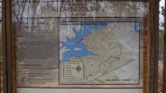
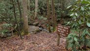
Starting Point: Park Visitor Center.
Trail Traffic: I saw a couple others at the trailhead, but no one else out on the trails.
How to Get There: From US Hwy 25 north of Greenville, SC, or south of Hendersonville, NC, take the Cherokee Foothills Scenic Highway (SC-11) south. Travel 4.3 miles to US-276 and turn right (joins with SC-11). Travel 19.6 miles on SC-11 and turn right on Cabin Rd. into Keowee Toxaway State Park. The Visitor Center is a tenth mile ahead on the right with plenty of parking.
It’s kind of amazing when you think about it… all the state parks that are lined up along the Cherokee Foothills Scenic Highway (SC-11). Starting with Jones Gap and Caesars Head, then on to Table Rock, followed by Keowee Toxaway and Devils Fork, then ending at Oconee. Quite a few choices for adventure. Keowee Toxaway is closest to the highway of all of them.
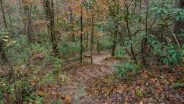
And while convenient for getting to the trailhead, the highway noise on the first half mile of the hike is a bit annoying as the Natural Bridge Trail pretty much parallels the road. The passing cars and trucks were definitely the first thing I noticed as I set out, but I eventually got over it and started paying more attention to the sights rather than the sounds.
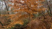
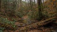
The first loop of this hike is the 1.3 mile Natural Bridge Trail. Short, but not necessarily easy for those who may just wander in from their couch in Nyak, NY wearing nothing but sandals. It drops about 200 feet along the Poe Creek drainage, meaning you have to climb back up to get to the trailhead. 15 minutes in, the sounds change from highway noise to the rushing of Poe Creek.
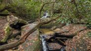
At the half mile mark you cross Natural Bridge. If you aren’t paying attention, you will probably walk right over it. It is a large granite slab, differentiated from the clay tread of most of the trail, but you really have to drop down over the side to see the opening beneath the rock. Probably about two feet high, it is indeed a natural bridge, but it pales in comparison to others I have visited. Look for a Poe Creek waterfall on your left a few hundred feet after the natural bridge.
Half way around the Natural Bridge loop is the junction with Raven Rock Trail, and the meat of this hike begins. You start climbing immediately up the slopes of McKinney Mountain, past massive granite outcroppings. This is primarily an oak/hickory forest, with occasional beech and pine to mix it up a bit. There is also lots and lots of mountain laurel, so I expect this to be quite resplendent in pink flowers come May.
After another half mile you reach the crest of McKinney Mountain, about 400 feet higher than the low point along Poe Creek. Now it’s downhill on the approach to Keowee Lake. This is the stretch of trail where you need to be careful. It crosses exposed granite in places. On the day I was there the granite was still wet from overnight rain. If you’re familiar with what happens to granite when it gets wet, you know to take your time and test your footing.
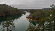
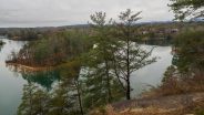
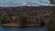
With the leaves down, I was able to see through the woods as the lake appeared about a quarter mile before I descended to its level. The Raven Rock Trail stays about 25 yards from the lake, but it is easy to walk through the woods for a clear view of the shoreline. Directly on the other side is the Cliffs at Keowee resort community, including its golf course.
The trail winds in and out of various coves in the lake shore, eventually reaching a small peninsula with a spur trail that takes you to three tent campsites. From the tip of the peninsula you have a great view of one of the golf greens as well as what used to be Estatoe Creek. Of course the former route of the creek is now filled with reservoir water. Look too for small sandy beaches that line the shore.

A Cliffs at Keowee resort greenskeeper tends one of his greens before the golfers arrive. This used to be Estatoe Creek.
When you return to Raven Rock Trail from the campsites, the ascent back up McKinney Mountain begins. A couple things I noticed throughout the hike were, a) there had been quite a bit of recent blowdown along the trails from frequent wind storms, but the state parks folks have done a remarkable job of keeping the trails clear (hat tip), and b) judging by the number of spider webs my face plowed into, apparently the spiders in South Carolina don’t mind cold weather. Perhaps the NC spiders migrate south for the winter.
It is about a third mile from the campsites to Raven Rock itself. When standing on Raven Rock, it doesn’t really seem like much, perhaps about 20 feet square, but the bulk of Raven Rock is beneath you. You can see by looking over the side that it is a massive wall of granite. From the lake in a boat, it would be quite impressive.
On this day it was also wet and slippery. Be careful, because if you go over the edge you will splash below. I could hear the rock whispering to me that it was time for lunch, so I pulled up a seat and pulled out my sandwich. While munching, I looked around a bit. Directly in front of you is a small island in the lake. It probably has a name, but I couldn’t find it. On the other side of the lake are more trophy resort homes in the Cliffs development.
You are also high enough here to see the Blue Ridge Mountains behind the shorter ridge nearest the lake. There was a nice wispy layer of clouds hovering near the Blue Ridge that enhanced the view. The lake itself was mirror still, creating very appealing reflections of the forest that surrounds the shore. All in all, a nice spot for a break.
Once I resumed hiking it was still about a half mile to the Raven Rock Trail loop junction, then another half back past all the granite outcroppings on McKinney Mountain to the Natural Bridge Trail junction. I turned right here to do the lower, western side of the NBT loop.
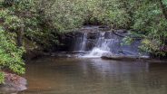
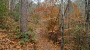
The trail drops another hundred feet alongside Poe Creek, including a set of stairs built into the somewhat steep hillside. At the bottom is a trail sign pointing the way across Poe Creek. Also at the bottom is another waterfall. This one is tiered, making a five foot plunge, then taking a sharp right turn and dropping another five feet… all surrounded by granite boulders and rhododendron. No doubt a very pleasing sight in June when the rhodo is in bloom.
After crossing the creek, the trail continues to follow the creek for a bit and then begins that final 200 feet ascent that I mentioned earlier. As the rush of Poe Creek disappears behind you, the traffic sounds on Hwy 11 announce that you are nearly back to the trailhead. There is one final twisty stairway to navigate, then the last quarter mile push back to the Visitor Center.
In summary, I’m likely to spend a lot more time at the South Carolina state parks this winter. The Upstate is 2,000 feet lower, and usually 8-10° warmer than the mountains. It took me only 65 minutes to get to Keowee Toxaway from my home, and Jones Gap, Caesars Head, and Table Rock are even closer than that. This double loop hike at Keowee Toxaway is a nice way to spend three hours. It’s not too hard, but will give you some exercise. This one should be fine for the whole family, even your pooch.

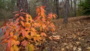


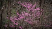
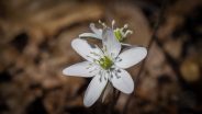
Update March 30, 2018: With Spring here and the weather warming, a search for early season wildflowers seemed in order. Somewhere along the Cherokee Foothills Scenic Hwy popped into my mind, so Keowee Toxaway it was. I wasn’t disappointed. While there weren’t a lot of flowers, there was quite a wide variety, and a good inkling of things to come. Not a lot happening with the trees yet, although I did see a few buds, and the maple seed pods were out, turning the tree tops a delightful red. Here’s some new pictures from my visit.


The following are paid links. As an Amazon Associate I earn from qualifying purchases.
 I am Jeff Clark, founder of Internet Brothers, producer of this blog, and passionate about hiking. I live in Western NC near the Blue Ridge and Great Smoky Mountains. Pisgah and Nantahala National Forests are just out my door, so the content will focus on these areas, but let me know what you would like to see on the site.


Copyright © 2011-2023 Internet Brothers. All Rights Reserved. ISSN 2324-6057
Designed by Elegant Themes | Powered by Wordpress | Logo by Design Aspirations

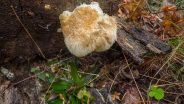
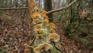
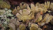
Nice to get in a vicarious nature walk. Really liked your photos with the one fallen tree with fungi on it. Amazing there is still fall color around. We have some still here in the Piedmont.