
Starting at the former site of George Vanderbilt’s Buck Spring hunting lodge near Mt. Pisgah, this hike crosses the summit of Little Bald Mountain before dropping down the watershed to Pilot Rock, one of the many plutons found within the Pisgah Ranger District. The high country is home to thickets of mountain laurel and rhododendron, while various maples, oaks and pines line the trail as you near Pilot Rock. Ken and I took this picturesque trek on Wednesday, October 19, 2016 beginning at 9:30AM and ending about 1:45PM. Our plan was to take Buck Spring Trail to its meeting with Pilot Rock Trail, visit the pluton, then return to the Laurel Mountain Trail for the finish.
Hike Length: 6 miles Hike Duration: 4.25 hours
Hike Rating: Moderate. Lots of climbing on the way back, but not particularly steep.
Hike Configuration: Down and back up Blaze: White, orange, blue
Elevation Change: 1,330 feet, 1,475 feet gain Elevation Start: 5,010 feet
Trail Condition: Fair. Very rocky along a good portion of the trail.
Starting Point: Buck Spring Overlook at Blue Ridge Parkway milepost 407.
Trail Traffic: We saw three other hikers and two mountain bike riders.
How to Get There: Take the Blue Ridge Parkway to Buck Spring Overlook at milepost 407.7. The trailhead is on the far right (southeast) side of the parking lot.
We have previously hiked to Pilot Rock from below. We thought we would try it from above this time. This is one of those oddball trails where the namesake is halfway through the journey.
This hike starts at the Buck Spring Overlook on the Blue Ridge Parkway. It’s a simple 500 foot walk from there to the former site of George Vanderbilt’s hunting lodge. Vanderbilt was the wealthy builder and owner of the Biltmore Estate in Asheville. Vanderbilt also kept 471 acres in Buck Springs Gap, about a mile from Pisgah Inn.
Here, Vanderbilt had constructed his popular log hunting lodge. The main lodge had four bedrooms, a breezeway-connected building had two bedroom suites, and the kitchen/dining building was connected to the other two. The site also included a spring house, the stone remnants of which are still visible at the site today. The lodge and outbuildings were razed in 1961 to make room for the Blue Ridge Parkway.
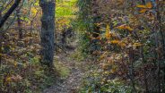
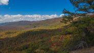
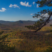
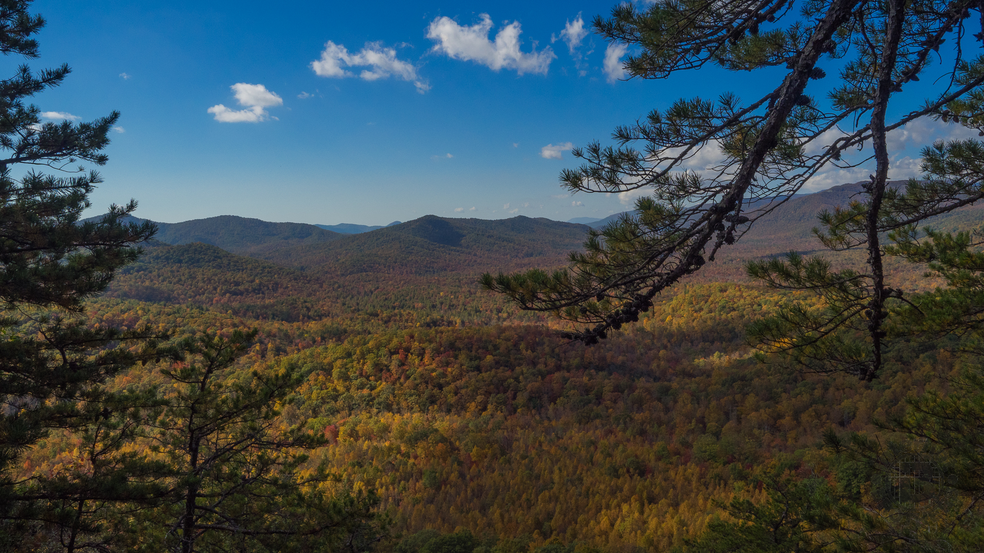
A magnificent view of the lowlands of Pisgah National Forest awaits you from the cliff at the edge of Buck Spring Gap. The downward descent of the ridge of Laurel Mountain marks one of the many pathways that dot this beautiful area. We continued on white-blazed Buck Spring Trail up and over Little Bald Mountain, a short climb to the summit at 5,256 feet.
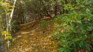
From that point, it is now a steady descent over 2.5 miles to Pilot Rock 1,300 feet below. Not far below the summit, Buck Spring Trail meets Pilot Rock Trail. The blaze color changes to orange. This trail passes through both mountain laurel and rhododendron forests, much of it very large and mature. Perhaps some of these thickets were even growing when George Vanderbilt was here in the late 19th century. A good portion of the upper reaches of Pilot Rock Trail are under a canopy of these thickets.
Vistas are mostly obscured by trees during the green season, but viewing is better when the leaves are down. Also, look for the occasional rocky outcrop that may offer a glimpse into the wide beyond.
About half way down the fall line, the forest changes from heath to hardwood. Some of the deciduous trees were displaying brilliant crimson and gold colorings on this day in mid-October. The color seemed to be best on the north side of the ridge.
Also, about half way down the trail gets very rocky. You’re entering pluton country. Over the millenia, the granite and shale at this elevation has broken up creating plenty of stumbling hazards for hikers and mountain bikers. Most riders will be carrying their bikes in this area between 4,500 and 3,900 feet.

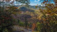
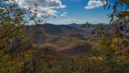
This view of Pilot Mountain in the distance is one of the few open vistas available along the descent of Pilot Rock Trail.
The descent gets a little steeper and switchbacks become the order of the day. There are more than a dozen. We passed a couple of hikers resting on an outcrop at one of these switchbacks, something we also did later on our way back up.
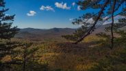
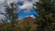
As we approached Pilot Rock the oaks and maples were really in color now. As you descend the trail, the rock face of Pilot Rock will be on your left. The angle of the open rock is extremely steep. If it is at all wet, especially icy, you probably don’t even want to get on it. It’s a long way down if you slip. Fortunately for us, this day was totally dry.
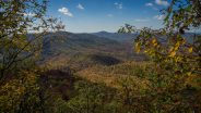
The views are magnificent. Straight down below you is the route taken by Forest Road 1206, also known as Yellow Gap Road, one of the most popular points of entry into Pisgah Ranger District. Spread out directly ahead is the entire expanse of the Cradle of Forestry, with 6,000 foot peaks on the horizon. The ribbon of the Blue Ridge Parkway cuts across Pisgah Ridge to your right. It was all alight with Autumn hues.
It’s a great place for lunch, but make sure all your gear is secure. I wrapped my pack strap around a low-lying blueberry bush stem to keep it from rolling down the pluton. As we munched on delicious burritos provided by Ken’s wife, we surmised how much stuff is probably laying in the woods directly below the face of Pilot Rock. There are probably entire packs down there, and cellphones, probably trekking poles too.
While we were eating and enjoying the view, a pair of bike riders meandered by. As one of them walked down the rock to say hi, the cleats on his clip-on riding shoes slipped dangerously on the steep rock face. Uh-oh. He managed to catch himself, but decided quickly that wasn’t a good idea and retreated to the safety of the trail. It is steep folks, so be very careful.
After about a half hour enjoying the fabulous view and the gorgeous weather, Ken and I were ready to tackle the climb back up. We took our time, resting occasionally. Once you clear the rocky area it becomes a lot easier.
We decided to mix things up a little on the way back, so we took the Laurel Mountain Connector over to Laurel Mountain Trail rather than returning up and over Little Bald Mountain. The half-mile-long connector trail skirts the east side of the summit of Little Bald.
Once we joined the blue-blazed Laurel Mountain Trail, we were back on the north side of the ridge, and the fall colors burst forth once again. This stretch of LMT back to Buck Spring Overlook is one large watershed. It is full of springs and other drainage that make the roots and boulders loose and slippery. Watch your step.
There are hundreds of little nooks and crannies beneath the large granite boulders that litter the hillside, likely home to all kinds of critters, with and without legs. Moist, bright green moss covers much of the rock, and galax is abundant beside the trail.
About a quarter mile from Buck Spring Overlook, Laurel Mountain Trail rejoins Buck Spring Trail for the final stroll back to the overlook. The parking area is shared with those hiking the Mt. Pisgah Trail, so if you still have some energy left you might want to consider that one too.
In summary, this is a hike of moderate difficulty that will give you a good workout and wonderful views of Pisgah National Forest from Pilot Rock. My favorite season for this hike is Fall because of the colors, but it is also very nice in Spring when the mountain laurel and rhododendron are in bloom. It’s hard to do in winter because access from the Blue Ridge Parkway is usually closed, but you can still get to Pilot Rock from below off of Yellow Gap Road. Give this one a try. I think you’ll like it.


The following are paid links. As an Amazon Associate I earn from qualifying purchases.
 I am Jeff Clark, founder of Internet Brothers, producer of this blog, and passionate about hiking. I live in Western NC near the Blue Ridge and Great Smoky Mountains. Pisgah and Nantahala National Forests are just out my door, so the content will focus on these areas, but let me know what you would like to see on the site.


Copyright © 2011-2023 Internet Brothers. All Rights Reserved. ISSN 2324-6057
Designed by Elegant Themes | Powered by Wordpress | Logo by Design Aspirations
I’m going to book mark this one. Been looking for trails out from this area and this is great info.
Hi Jeff, just a quick note that the first map doesn’t match the second one – it appears the first is the Yellow Gap Rd to Pilot Rock section, while the topo map features Buck Springs to Pilot Rock. Otherwise thanks for the trail info – we hiked this last week and enjoyed some pretty epic views.
Good catch Liene. Thank you very much for letting me know. I have corrected the error now.