
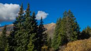
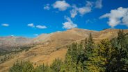
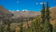
There’s a reason they call it Summit County. An old mining road climbs from Hoosier Pass above 12,000 feet and is surrounded by several of Colorado’s famous fourteeners. The first half of the road meanders through a spruce and fir forest with occasional views of the massive mountains that envelop the region. The rest of the way is above treeline, offering unobstructed viewing of giants Mt. Bross, Mt. Lincoln, Mt. Silverheels and Quandary Peak. The north side of the ridge also has long distance vistas of more fourteeners, several ski areas, and Dillon Reservoir. My brother Dave and I walked County Road 2 at Hoosier Pass on Saturday, October 1, 2016 beginning at 9:00AM and ending about 12:15PM. Our plan was to climb to the crest of the ridge beneath Northstar Mountain summit on County Road 2.
Hike Length: 3.8 miles Hike Duration: 3.25 hours
Hike Rating: Moderate climbing. Some rocky mining road. Watch for talus.
Hike Configuration: Up and back Blaze: None available
Elevation Change: 610 feet Elevation Start: 11,660 feet
Trail Condition: Old mining road. Will be dusty during dry conditions.
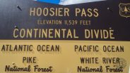
Starting Point: Hoosier Pass on Highway 9.
Trail Traffic: We saw about two dozen other hikers on this sunny Autumn day.
How to Get There: Travel 11 miles south on state highway 9 from Breckenridge to Hoosier Pass. The old mining road is on the west side of the parking area.
Our original plan was to hike McCullough Gulch Trail up the watershed of Quandary Peak. When we arrived at the trailhead, however, it was closed for maintenance. So my quick thinking brother came up with an alternative. If we continue on up Highway 9 to Hoosier Pass, there is an old mining road that more or less parallels Monte Cristo Creek, just a thousand feet higher.
Hoosier Pass is a major crossing of the Continental Divide between the towns of Breckenridge and Alma, so the overlook there was already quite busy even at 9:00 AM. The name derives from a share of the pioneer settlers of the region being natives of Indiana, hence Hoosier. The pass is located at the northern end of the Mosquito Range, in a gap between Mount Lincoln and Hoosier Ridge. It sits on the boundary between Park and Summit counties, and between Pike and White River National Forests.
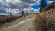
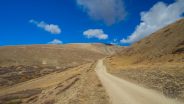
Because we were in a 4WD, we were able to drive about a quarter mile up County Road 2 (also known as Ling Road) to a pullout under a grove of spruce trees. Don’t try it in a conventional sedan, but the additional walk from Hoosier Pass isn’t difficult.
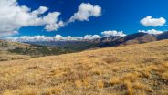
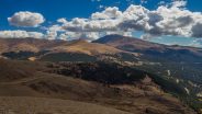
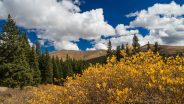
Think of County Road 2 as your typical dirt road, without gravel. It’s just tan dirt… no doubt quite dusty during the dry season. Through the groves of spruce and fir, you notice immediately the gargantuan shapes of Mt. Bross and Mt. Lincoln on the west side of the viewshed.
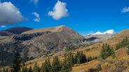
Both are well above 14,000 feet, with Lincoln being the tallest peak in Park County. Mount Lincoln, along with its neighbors Cameron, Democrat and Bross, are pockmarked with old mines, and much of the land is still owned privately by mining companies. In the summer of 2005, these landowners denied access to the peaks to hikers and climbers, fearing liability in the case of injury, and citing the particular dangers due to the presence of old mine workings. In 2006, the town of Alma signed a deal to lease the peaks for a nominal fee, to reduce the potential liability to the owners and free up the peaks for recreational access. For those who do such things, all these fourteeners are now usually peak-bagged together, in the same hike.
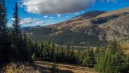
As you begin to clear the treeline, Montgomery Reservoir also comes into view on the west side of the road. This man-made lake about a mile southwest of the pass is part of the Continental-Hoosier Diversion System. Water is piped from Montgomery Reservoir 70 miles to Colorado Springs.

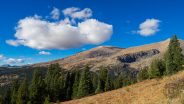
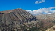
The imposing summits of Mounts Bross and Lincoln, with more of the Mosquito Range in the background.
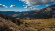
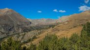
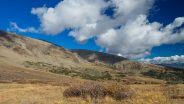
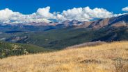
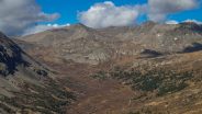
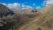
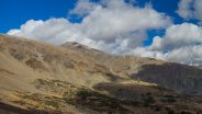
About a mile and a half up the road we reached a saddle along Hoosier Ridge, and we could now see the east side of the ridge. The view is simply magnificent. Down below is Monte Cristo Creek drainage. 14,271′ Quandary Peak, with its commanding ridge line is now visible from behind Northstar Mountain. Quandary is one of the most popular climbs among Colorado’s 14ers because of its relative proximity to Breckenridge and Denver. Through our zoom lenses, we could see the ant-like hikers making their way up the long ridge.
Also visible are ski slopes and other fourteeners. Torreys and Grays Peaks are in the vista along with portions of Keystone Ski, Dillon Reservoir, and the outskirts of Breckenridge. I’m sure with binoculars you could also see the town of Frisco as well as other famous landmarks far too numerous to mention.
We paused here for a break for a snack and to enjoy the bounty surrounding us. Our next target was the gate a few hundred yards higher up County Road 2. When Dave was last here a decade prior, the path to the summit of Northstar Mountain had been closed because of the aforementioned old mine issues. We had to go see what the status now was.
When we arrived at the gate there was definitely a no trespassing sign. But it looked to us like that was for the upper road that continued climbing up Northstar. The lower road that wound around the ridge toward a vista of the Mt. Clinton watershed did not have a gate, or a sign. At least that’s what we were going to tell anyone who might have asked why we continued ahead.
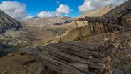
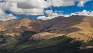
We walked perhaps a quarter mile around the ridge to a spectacular view, looking up the drainage from Mt. Clinton. We both thought the road/path far below in the drainage would be a great one to explore some day. Eventually we reached a talus field and old mining artifacts, a definite signal that it was time to turn around.
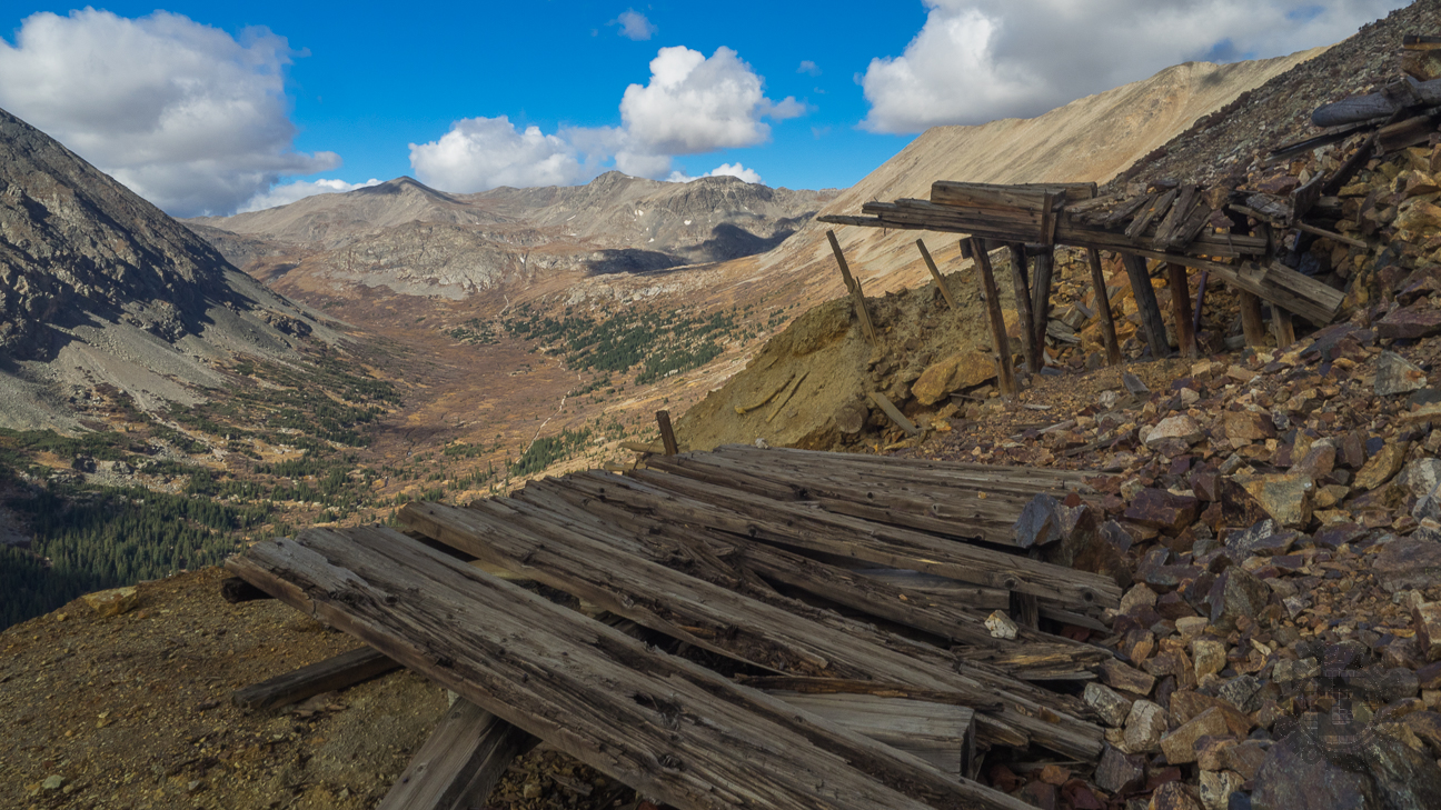
The tailings and artifacts were definite hints that we were in what was once mining country.
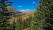
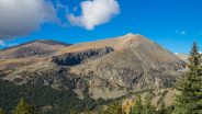
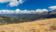
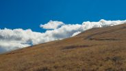
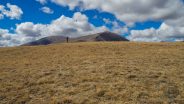
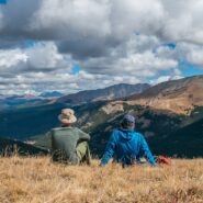
We went back to the saddle and began another climb to a knob at the top of Hoosier Ridge. From there we felt like we were simply in the center of it all. That’s what you see in the photo at the top of this post. We were surrounded by amazing views of tall peaks in every direction, including the now-visible 13,829′ Mt. Silverheels, named for a dance hall girl in the nearby mining camp of Buckskin Joe.
She was nicknamed “Silverheels” because of the silver shoes she wore while dancing. She also wore blue or white masks to conceal her face. Well-compensated by the trappers and prospectors who watched her dance, Silverheels was personally generous, having used her own money to bring in doctors during a smallpox epidemic in Buckskin Joe in 1861.
We pulled out our lunch and setup the tripod for pictures and just enjoyed the moment. The clouds were beginning to gather over the tall peaks, a very common afternoon occurrence in the Rockies. They really add to the perspective in photographs, but you don’t want to be exposed on an isolated peak when those clouds begin throwing lightning bolts in every direction. There is a good rule of thumb for hiking in the Rockies: off the mountain by noon.
And so it was that we sadly left our exhilarating perch on the knob and began the descent down the north side. There were a lot more people going up County Road 2 now that we were going down. Hopefully they all kept one eye on the gathering clouds.
Summarizing County Road 2 from Hoosier Pass, this is a mostly easy hike that climbs gently a little more than 600 feet to a knob on Hoosier Ridge just below the summit of Northstar Mountain. If you’re new to high altitude hiking, the 12,000′ elevation may surprise you. Take your time and breathe deeply. The views along the way are simply majestic. The Mosquito Range is one of the most dynamic among the great mountains of the Rockies. This hike is mostly doable in any season as the road crews do a good job of keeping Hoosier Pass open all winter.


The following are paid links. As an Amazon Associate I earn from qualifying purchases.
 I am Jeff Clark, founder of Internet Brothers, producer of this blog, and passionate about hiking. I live in Western NC near the Blue Ridge and Great Smoky Mountains. Pisgah and Nantahala National Forests are just out my door, so the content will focus on these areas, but let me know what you would like to see on the site.


Copyright © 2011-2023 Internet Brothers. All Rights Reserved. ISSN 2324-6057
Designed by Elegant Themes | Powered by Wordpress | Logo by Design Aspirations