
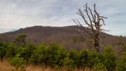
August 2005 saw the Carolina Mountain Land Conservancy and The Nature Conservancy purchase a 1,568-acre tract of land south of Lake Lure known as “World’s Edge” for $16 million with the intention of transferring the land as the first to be added to the new Chimney Rock State Park. World’s Edge contains a mile-long set of steep slopes on the eastern edge of the Blue Ridge Escarpment, with more than 20,000 feet of streams and waterfalls.
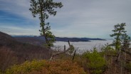
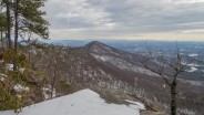
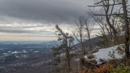
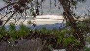
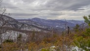
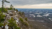
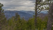
From an overlook point, the land falls away to the southeast providing a stunning view of North Carolina’s Piedmont. On the northwest side, the area provides habitat for rare flowers, diverse forest communities, endangered bats and salamanders, unique cave-dwelling invertebrates, and birds such as peregrine falcons and migratory neo-tropical species. Transfer of the World’s Edge tract to state ownership was completed in 2006.
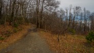
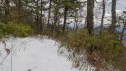
Primitive trails pierce the rugged landscape, offering a view of things to come for the courageous souls willing to get a scrape or two and bushwhack the craggy rim. The state park’s master plan mentions further trail development and visitor amenities on this corner of the property, including permanent overlooks, backcountry campsites, and a day use area. However, with funds being tight in state government, don’t look for any of this to occur in the near term.
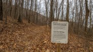
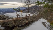
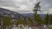
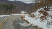
In the mean time, you can access World’s Edge from Edneyville, NC via Gilliam Mountain Rd. and Sugarloaf Mountain Rd. to Ottanola Gap. There is limited parking in the cul-de-sac at the gap. Please don’t block access to the private drive that is also there. You can follow the old 4wd road to the first overlook and beyond. For an easy 2-mile out and back hike, continue to follow the road, with stops at each of the 3-4 overlooks along the way. You drop approximately 200 feet of elevation on the way out.
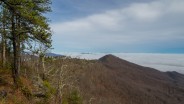
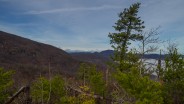
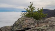
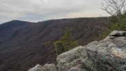
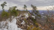
For the more adventurous among you, there is a very primitive trail from the first overlook that follows the extreme edge of the rim as far as Chinquapin Gap. Be warned that there is exposure of falling from rock outcrops along the rim, and that some bushwhacking will be required. Otherwise, this trail offers the best views of both sides of the rim, including Sugarloaf and Chimney Rock Mountains to the west, and the Pool Creek drainage into Lake Lure Village.
With the photo gallery below, I hope to portray a pictorial essay of what NC residents and tourists have to look forward to in the coming years as the World’s Edge tract is developed for state park access. There is a grand plan for all of the magnificent Hickory Nut Gorge that may take a couple of decades to achieve fruition, but when it is complete this area will rival anywhere in the country for recreational opportunity and breathtaking scenery.
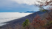
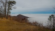
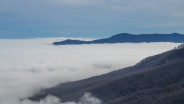
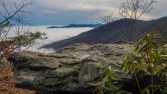
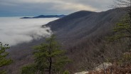
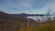
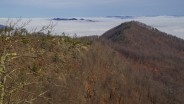
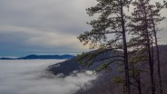
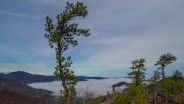
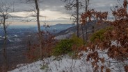
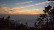
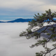
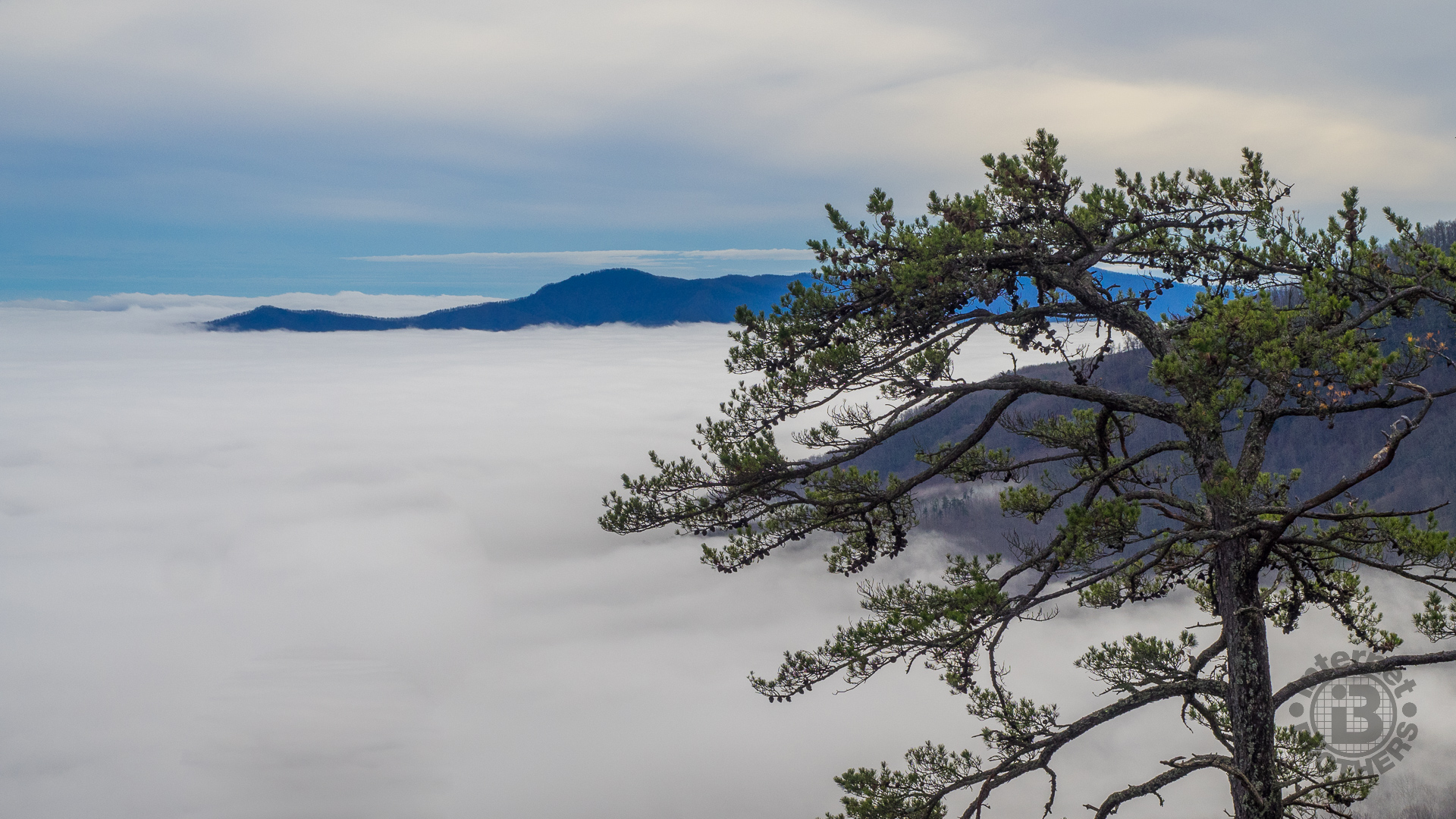
I visited on December 22, 2015 and was treated to a cloud inversion on both sides of the World’s Edge rim.

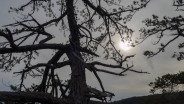

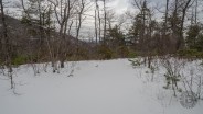
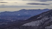
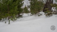
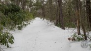
Update January 26, 2016: Winter storm Jonas blew through the Carolinas on its way up the east coast depositing several inches of snow along its path. It made getting around quite a mess for a few days, but finally I got brave enough to make some fresh boot prints at World’s Edge. Several others had made it to the first overlook, but I was the initial one to follow the game trail along the ridge to Judea Gap. I found evidence of coyotes, but otherwise it was a lonely, serene place.
After a couple days of melting, I would judge the snow to still be about 10 inches deep with some drifts up to my knees. Hiking across the ridge in the deep white stuff was exhilarating. As you will see from the pictures below, the sky was pretty mean looking, but I didn’t encounter any bad weather. Let me know what you think in the comments below.
Update November 2, 2016: How about a World’s Edge sunrise?


The following are paid links. As an Amazon Associate I earn from qualifying purchases.
 I am Jeff Clark, founder of Internet Brothers, producer of this blog, and passionate about hiking. I live in Western NC near the Blue Ridge and Great Smoky Mountains. Pisgah and Nantahala National Forests are just out my door, so the content will focus on these areas, but let me know what you would like to see on the site.


Copyright © 2011-2023 Internet Brothers. All Rights Reserved. ISSN 2324-6057
Designed by Elegant Themes | Powered by Wordpress | Logo by Design Aspirations
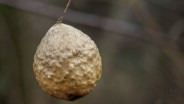
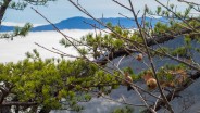
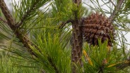
Hi Jeff, I believe what you have in your pictures are not oak seeds (which would be acorns) but in fact galls, created by wasps laying their eggs on the leaves and twigs.
This looks to be an otherwordly area to hike in – can’t wait to see that edge of the Blue Ridge. Thanks for the picture tour!
Indeed. Thanks Liene.
Amazing post Jeff. I can’t wait to get up there. I have hiked to the summit of Sugarloaf, but was not familiar with the World’s Edge area. Your photos are just breathtaking, and the cloud inversion is something I’ve never seen in person. Thank you and Happy Holidays.
Thanks Jeff. I grew up going to that private resident to the right of the Cul De Sac every year until I was nearly 30. I know every inch of World’s Edge and there’s no place on earth more beautiful to me.
Next time you’re there, I challenge you to find Natural Bridge. We told the Rangers about it when we sold the property to the State Park, and they found it within a few weeks.
Here’s a picture we took from the house one morning.
https://uploads.disquscdn.com/images/7e968a65929f83f0d46047c8a206b5e70718ddba7b8cf465b52738af4f11ff96.jpg
Thanks for sharing your photo. I’ll be keeping an eye out for the natural bridge.
Glad to share it. Here’s a picture of half our family sitting on Natural Bridge. It’s a LIVE tree, with two live trees growing up either side all equally thick. It must be hundreds of years old. You’ll need to hike down from the old barn (where we kept the tractor) next to the parking area, and follow the stream from the artesian well. The tree crosses the stream. You can’t miss it.
If you make it, please take a picture.
https://uploads.disquscdn.com/images/6eb5fe7b9c65935659ec242ccdf8db328c604195eca8b46e38e1aa8314076f44.jpg