
Hiking among the giants of the East. That’s what you’re doing when you take the Blue Ridge Parkway to Mt. Mitchell State Park for this trek on the Mountains to Sea Trail in the Black Mountains. With fabulous views of the Blacks and the Great Craggy Range, and closeup experiences with gnarly old growth fir and spruce krummholz, this stretch of the MtS is some of the best of the North Carolina high country. The trail climbs through ancient forest, past moss-covered granite outcrops, to the crest of the ridge and Blackstock Knob summit. From here you can almost reach out and touch Mt. Mitchell, the tallest peak in the East. Descend to Balsam Gap, then return on perhaps the most scenic stretch along the entire length of the Parkway. We thoroughly enjoyed this hike on Wednesday, July 30, 2014 beginning at 11:00AM and ending about 5:30PM. Our plan was to take the Mountains to Sea Trail from Mt. Mitchell State Park across Blackstock Knob and down to Balsam Gap, then return along the Blue Ridge Parkway.
Hike Length: 11.3 miles Hike Duration: 6.5 hours Hike Configuration: Loop
Hike Rating: Difficult. Combines high altitude, strenuous climbing, and distance.
Elevation Gain: 1,960 feet Elevation Change: 1,140 feet Blaze: White
Trail Condition: Very good. Considering the extremely rugged terrain, this section of trail is in surprisingly good condition. Just watch for roots and rocks.
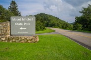
Starting Point: Mountains to Sea trailhead on Hwy 128 in Mt. Mitchell State Park.
Trail Traffic: We encountered one other hiker, and one trail maintenance worker.
How to Get There: From the Blue Ridge Parkway milepost 356 take NC Hwy 128 into Mt. Mitchell State Park. It is approximately a half mile to the MtS trail marker on the left. There is enough parking for 3 cars on the right.
This majestic hike could easily be accomplished as a shuttle, or two-car excursion as there is convenient parking at each end of the trail. The big problem, though, is the extreme remote nature of Mt. Mitchell State Park. It is only accessible via the Blue Ridge Parkway, and it’s at least an hour drive from Asheville, or any other town nearby. So using two cars would involve quite a bit of fuel. You decide. It’s 5.9 miles one way, or 11.3 miles as a loop.
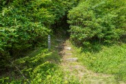
We chose to begin the hike from the Mt. Mitchell end as climbing to the ridge crest is more gradual. Once seeing the descent at the Balsam Gap end, I think we made the correct decision. The trailhead for the Mountains to Sea Trail is about a half mile up Hwy 128 into Mt. Mitchell State Park. Look closely to your left as you approach, because it isn’t especially easy to notice. There is a small gravel pullout on the right side of the road with enough room for three tightly bunched vehicles.
The trail starts out heading due south and uphill for a quarter mile, then levels out and makes a hard turn northwestward. We noticed immediately that someone had been through very recently with a scythe or weed eater, making the trail extremely easy to navigate. It was also apparent that a lot of time and love had been put into appropriate rock placement and trail tread leveling to ease the ascent.
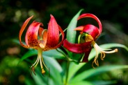
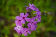
On our way up the Parkway from Asheville in the morning, when we reached the high country past Craggy Gardens, the roadway was lined with an assortment of wildflowers that would make the NC Arboretum proud. Our first wildflower on the trail was a stunning Turk’s Cap. Usually orange in color, this one was nearly red and stood almost shoulder height. Obviously, a mature plant. Our wildflower experience was just beginning.
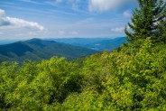
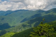
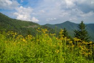
At roughly a half mile into the hike, the trail pops out of the forest and opens up the entire expanse of the Asheville Watershed. To the south are Greybeard Mountain and Brushy Knob. To their west the Burnett Reservoir, and further west the twin peaks of the Great Craggy Mountains: Craggy Dome and Craggy Pinnacle. Climbing a little farther up the face of Potato Knob, we reached a parapet-like outcropping that showed us the winding pathway taken by the Blue Ridge Parkway to reach those landmarks.
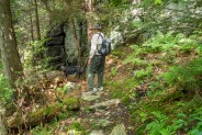
While sitting on the outcropping enjoying the grand view and a snack, we could now hear the sound of a motorized weed eater not far above us. Darn! That meant the nicely mown path would be ending soon. Sure enough, 10 minutes later we encountered the intrepid (and tired) worker and thanked him profusely for his efforts. We chatted with Mike Williams of the Carolina Mountain Club for awhile and learned that he is frequently up here in the Blacks doing much appreciated trail maintenance.
As coincidence would have it, we also met the only other hiker we would see on this day, coming the other direction. Thinking our way forward would now be surrounded by waist high grass and weeds, we said our farewell to Mike and pushed onward.
Soon afterward, we re-entered the forest, and were rewarded with short ground cover alongside the trail. And it remained that way throughout. Our timing had been perfect. The worst of the tall grass had already been taken care of by Mike.
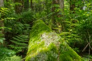
We also began climbing again, now rather steeply, up the south face of Potato Knob toward the ridge crest on the knob’s west flank. Rather large outcroppings were scattered about, covered in moss and lichens, a result of the hundreds of inches of rainfall that occur in this region each year. Grace, my companion’s black & tan hound, was thoroughly enjoying herself. The scents were doggie nirvana.
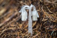
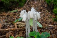
We began noticing teeny, tiny white growths poking just a few inches out of the ground. Seemingly part floral and part fungus, Dave informed me these are known as indian pipe. They grow where the soil is very moist, push their way through fallen evergreen needles and lichens, and stay together in clusters. There were literally hundreds over the next mile of trail. It seems every time I foray into the wilderness I learn about something new, and on this day it was indian pipe. Dave said he had never seen so many in one area before.
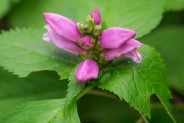
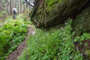
When you reach the ridge crest, the trail levels out, then roller coasters for a mile or more. You’re above 6,000 feet now and will likely notice it in your breathing. The forest is amazing here. You’re surrounded by spruce and fir krummholz, and if you look closely, amid the moss and lichens you will find dozens of little micro gardens with various hues of mushrooms and other fungus springing from the moist rotting wood. We also found the first turtleheads of summer and pockets of chickweed hugging the stone outcrops.
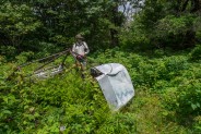
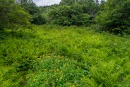
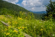
Upon reaching the low point along the ridge at Rainbow Gap, we began looking for a meadow off to the north, a tip Mike had given us. He said there is a Cessna crash site less than a hundred yards off the trail. Sure enough, we found the fern and St. John’s Wort adorned meadow, and then the wreckage at the southeast corner. The cockpit and left wing were still somewhat intact, but all the instruments and the rest were long gone. It was obvious the pilot had missed the gap by mere feet.
Returning to the trail, we were now looking for a place to have lunch. The next stretch of trail up Blackstock Knob is the hardest of the hike. It’s about 325 feet of elevation gain from Rainbow Gap to the summit, all steep. By the time we found a nice spot to eat, we were definitely needing the rest, and the nourishment. The moss on the summit is incredible. I found one fallen log that I counted five different species of moss on, and it was more than an inch thick.
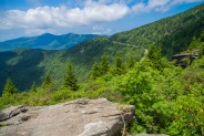
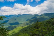
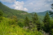
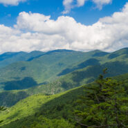
Continuing westward, occasionally the forest would open to the north for just a faint peek at the Black Mountains Range nearby. Suddenly the peeking became a full-blown view when we reached what I would call a photographer’s overlook. The trail maintenance crew had carved out a small pathway through the brush right to the precipice of the ridge. The full length of the Blacks was directly in front of us, with the Big Tom Preserve down below. The scene is sensational, and is the photo at the top of this post. Normally I’m not a fan of trail crews destroying living plants, but in this case I think the view was well done.
We were really beginning to wonder when this trail would start heading down. The summit of Blackstock Knob is 6,330′ and the elevation at Balsam Gap is 5,320′. So we had a thousand feet of drop ahead with not much trail left. Sure enough, the descent began in earnest.
A seemingly endless series of switchbacks helped make it easier on the knees and ankles, but this is serious downhill. Dave mentioned that on a previous visit to this trail he had come up from Balsam Gap. Worn out when he reached Blackstock Knob, he decided to turn around. I can see why. I’m glad we started at the other end.
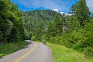
Finally after about 20 minutes of continuous down, down, down we popped out on the Blue Ridge Parkway at Balsam Gap. It had taken us four hours to get here from the other end. Granted we stopped for lots of pictures and such, but four more hours back didn’t seem like a good idea. Dave suggested we walk back on the Parkway to make this a loop, and he didn’t hear any complaints from me.
By the way, there is another trailhead at the Balsam Gap pullout besides the Mountains to Sea. It is called the Big Butt Trail. It follows Brush Fence Ridge to Point Misery and beyond and supposedly has dazzling views of the Black Mountains from across the valley that is the Big Tom Preserve. Just another hike for another day. It is so wonderful to live in Western North Carolina.
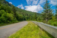
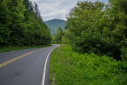
Well, we still had nearly five miles back on the Parkway, and then that last half mile up Hwy 128 in the state park back to the car. Might as well get started. Walking on the road is certainly easier, and quicker, than hiking over roots and rocks in the forest, but there’s still quite a bit of stamina-draining uphill. What made it so much easier to endure was all the wildflowers.
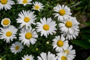
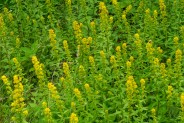
Along the way, I saw daisies, and coneflowers, and black-eyed susans; bee balm, and geraniums, and turk’s cap. I even saw the first goldenrod of the season. Yep, in the high country it pops out even in late July. Rounding one curve in mile 357, we could see the outcrop high above where we had stopped earlier for a snack.
The Parkway is very impressive here. The work that was accomplished by the builders more than 70 years ago is truly amazing. I think this 10-mile stretch from Craggy Gardens to Mt. Mitchell is some of the most beautiful along the full 469-mile length. There wasn’t much gas left in my tank for that final trudge up Hwy 128, but six and a half hours after starting, we finished.
Best Hike Let’s summarize. You should definitely do this hike. The high country forest is luscious, and the mountain vistas on both sides of the ridge are stunning. Even if you don’t go all the way to Balsam Gap and back, consider trying at least part of this section of the Mountains to Sea Trail for a fine example of what WNC hiking is all about. I would call this one a Best Hike.


The following are paid links. As an Amazon Associate I earn from qualifying purchases.
 I am Jeff Clark, founder of Internet Brothers, producer of this blog, and passionate about hiking. I live in Western NC near the Blue Ridge and Great Smoky Mountains. Pisgah and Nantahala National Forests are just out my door, so the content will focus on these areas, but let me know what you would like to see on the site.


Copyright © 2011-2023 Internet Brothers. All Rights Reserved. ISSN 2324-6057
Designed by Elegant Themes | Powered by Wordpress | Logo by Design Aspirations

