
Peaceful. If I were to think of a single word to describe the Pink Beds Loop Trail, that would be it. Peaceful. Located in a high valley in the Cradle of Forestry, Pink Beds is surrounded by the tall mountains and lush woodlands of Pisgah National Forest. Home to rare mountain bogs, unique vegetation, and unusual wildlife, this area is ideal for those who like to explore Nature. The south side of the loop trail follows the headwaters of South Mills River, often on a boardwalk that enables you to peer into the water of the marshy bogs. This is a flat, easy hike, but keep in mind that it is six miles long. My hike occurred on Wednesday, July 24, 2013 from 8:00am to 11:00am. My plan was to take the Pink Beds Loop Trail counter clockwise, with a stop along the Barnett Branch connector.
Hike Length: 6.2 miles Hike Duration: 3 hours Blaze: Orange
Hike Configuration: Loop Elevation Gain: 270 feet
Hike Rating: Easy, but pay attention to the length.
Trail Condition: Mostly good, but watch for roots and mud.
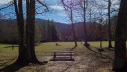
Starting Point: Trailhead at Pink Beds picnic area on Scenic Hwy 276.
Trail Traffic: I had the place all to myself until the last mile, when I encountered about 50 teenage trail runners. That is unusual however.
How to Get There: From Brevard, NC take Scenic Hwy 276 into Pisgah National Forest. Go 11.4 miles to the Pink Beds Picnic Area, just past the Forest Discovery Center. The trail is at the gate near the back of the parking lot.
It’s a delightful drive up Scenic Hwy 276 to Pink Beds. Along the way you’ll pass the Pisgah Ranger Station, Looking Glass Falls, Sliding Rock, and follow Looking Glass Creek as it tumbles down the mountain to meet Davidson River. When you reach the Forest Discovery Center at the Cradle of Forestry, you’re almost there. It’s just another few hundred yards.
There’s plenty of parking at Pink Beds, as it is also a very large family picnic area. The trailhead is located near the back of the parking area next to a large wooden sign with a painted map of the trail. There is a Forest Service gate at the trailhead. As you enter the trail, stay to your left, otherwise you will end up in the picnic area.
You will cross Pigeon Branch, then reach the junction for the Pink Beds Loop. Either fork will take you around the loop — for purposes of this trail report, I went counter-clockwise — I took the right fork.
The trail is blazed orange. The only time that really matters is at the junction with the Barnett Branch Trail. Otherwise, the Pink Beds Loop is very easy to follow. There has been a ton of rain in Western North Carolina all summer, so the trail was pretty muddy. Add to that the fact that it’s naturally marshy, and you should wear appropriate footwear to go squish.
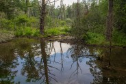
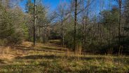
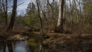
You will notice all the way around Pink Beds Loop just how flat the trail is. It’s very unusual for Pisgah National Forest, known for ridge after ridge after Blue Ridge. Pink Beds lies in a high valley, at roughly 3,200 feet. Less than half a mile into the hike you’ll begin to hear trickling water as the trail parallels the South Fork of Mills River, and the ground gets wetter and wetter. You’re entering mountain bog country.
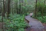
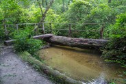
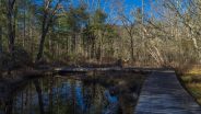
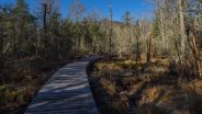
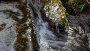
You will also see a new feature of the Pink Beds Loop, the recently constructed boardwalk system. Because of beaver dams and bogs and floods, the south side of Pink Beds along the river was nearly always under water. This side of the loop was basically unusable for years. Every time the forest service would beef up the trail and crossings, the rainy season would come and wash it all away again.
This time they got serious. The boardwalk system is built to last. Besides assisting the crossing of the bogs and river, the boardwalk serves the educational purpose of allowing us a closeup view of the water and its contents as we traverse the terrain. Make sure you take the time to sit on the boardwalk and peer into the bog. You never know what you might see.
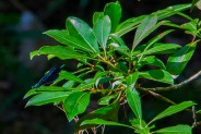
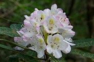
Despite the late season, some of the rosebay rhododendron was still in bloom. The rhodos are a real treat for three full months here in the Southern Appalachians. The Carolina variety display their colorful blossoms in May, followed by the bright pink and purple of the catawba blooms of June. July is reserved for the white and pale pink rosebays to complete the seasonal display.
Pink Beds originally got its name from the vast array of laurels and rhododendrons that enhanced the valley each spring. Over the past century, the foliage has changed somewhat, but there are still plenty of wildflowers to pique your senses.
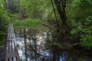
About a mile into the hike, on a long stretch of the boardwalk, you’ll come to the first of the beaver dams. Adding the floods created by the dams to the bogs makes this quite a large wetlands area. If you’ve ever spent time in the coastal Carolinas you will be reminded of that. It seems unusual to be walking amid swamp in the heart of the Blue Ridge Mountains.
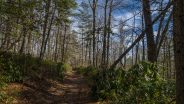
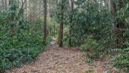
Once you get past the dam, the trail enters deep woods more typical of Pisgah National Forest. Pink Beds was part of the Cradle of Forestry back in the 20th century. There was a technical school here where rangers, woodsmen, and environmentalists learned cutting-edge forest management principles and techniques that have carried forward throughout the country ever since.
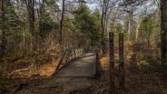
Keep an eye out for the best views of the river bank. South Mills River is now on your left. There are points along the trail to wade right into the clear, clean, crisp river water. You’ll come to Barnett Branch on your left, another boardwalk that was built about five years ago. If you want to shorten your hike, Barnett Branch is a 1/4 mile cut-through to the other side of the Pink Beds Loop. Otherwise, continue straight ahead, but only for a hundred feet, or so. There’s another junction with Barnett Branch. Here, the Pink Beds Loop goes left.
There is another series of beaver dams in this area where Barnett Branch meets South Mills River that simply became too difficult to navigate, so the trail was re-routed a few years ago. It climbs a little higher in order to avoid the wetlands created by the dams. Look for a brief view of the surrounding mountains while skirting the dams. In winter, when the leaves are down, this is a particularly scenic area.
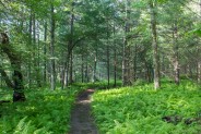
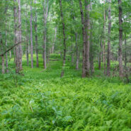
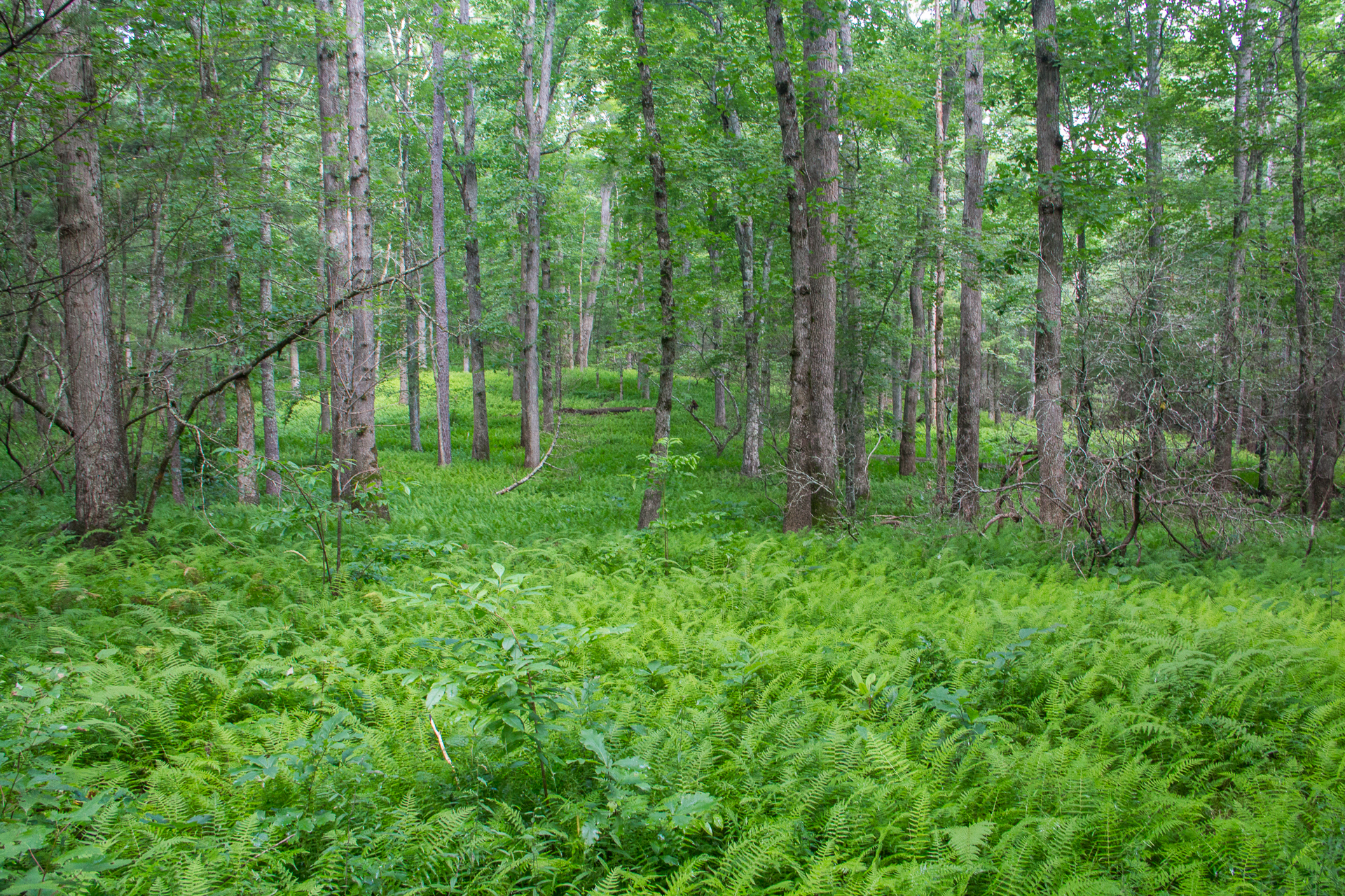
Continuing westerly, the trail eventually gets back down to river elevation, and enters what I call “Fernwood Valley.” My homage to the 70’s soap opera parody Mary Hartman, Mary Hartman and its equally crazy spin-off Fernwood 2Night, the next couple miles of trail is lined with millions of ferns — in the woods — Fernwood. All kidding aside, the ferns are stunningly beautiful. Click the photo at the top of this post.
The trail takes a turn to the north and crosses the river on a wide footbridge one last time. Soon you will come to a junction with a spur trail that goes to the South Mills River Guaging Station, and then on to Forest Service Road 476. There’s a whole other section of trails that can be explored from there.
For this hike, though, you want to turn left (east) to stay on the Pink Beds Loop. The foray through the ferns continues for quite some time as the forest becomes beautiful hardwoods, poplar and oak particularly. You will encounter several small stream crossings, some with log footbridges, others with rock hops. Shortly after crossing Barnett Branch, you will reach the northern junction with the Barnett Branch Trail.
Soon after passing that marker, I encountered a lone runner coming the other way. She hurriedly ran past me, and said, “There are a lot of runners coming.” I thanked her and continued on my merry way for about five minutes. Then they came, and came, and came. In waves of 5-6 at a time, for the next 10 minutes there must have been at least 50 teenage cross country trail runners splashing through the creeks and mud totally oblivious to the old man standing in the weeds out of their way.
The last mile of the northern side of Pink Beds Loop is a series of eight small meadows that are maintained by the Forest Service for wildlife management. You may have noticed when you pulled into the Pink Beds parking lot that there’s a sign indicating Wildlife Viewing. If you get up very early, or stay very late, and hang around quietly at one of these meadows, you have a good chance of encountering deer or wild turkey as they come out of the forest to feed.
It took me three hours to do the six mile Pink Beds Loop, with lots of stops for pictures, and to enjoy the unusual scenery and botany of the mountain bogs and river valley. It’s an easy stroll, one doable by even novice hikers. If you bring young children, keep a very close eye on them as there are lots of places to fall off the boardwalk. It may be a bit too long for really young ones, and for those who haven’t hiked in awhile. Consider using the Barnett Branch cut-through to shorten the hike by about half if need be.


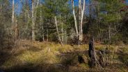
Update December 2, 2016: With wildfire all around the Southeast, I wanted to get into the woods for some quiet time to forget the sadness and to get away from the smoke. I remembered how peaceful it always is at Pink Beds. Plus, I had never been there in late Fall. Most of my previous visits have been in Spring or Summer.
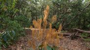
As you will see from these new photographs, the Pink Beds Loop and the wetlands near the headwaters of South Mills River look entirely different in this “dead season.” But like everything in Nature, if you look hard enough you can always find beauty.


Update December 29, 2017: Cold seems to have set in for awhile, but hiking can still be enjoyable. Just layer up your clothing and it isn’t much different. You’re likely to have more solitude out on the trails as well.
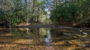
This time I took the Pink Beds Loop in the opposite direction; clockwise. Water level in South Mills River was way down, revealing large portions of the flood plain.


The following are paid links. As an Amazon Associate I earn from qualifying purchases.
 I am Jeff Clark, founder of Internet Brothers, producer of this blog, and passionate about hiking. I live in Western NC near the Blue Ridge and Great Smoky Mountains. Pisgah and Nantahala National Forests are just out my door, so the content will focus on these areas, but let me know what you would like to see on the site.


Copyright © 2011-2023 Internet Brothers. All Rights Reserved. ISSN 2324-6057
Designed by Elegant Themes | Powered by Wordpress | Logo by Design Aspirations


Great blog Jeff. We’d love to have a guest post on Blue Ridge Parkway Daily if you have time!
Nice post Jeff. Looking to do this in May 2014 with my wife. It will be my wife’s first “longer” hike after her First Metatarsophalangeal Joint fusion surgery back in Jan 2014…looks easy enough!
Yep. This is an easy one Joe. Best of luck for your wife.