
Cedar Rock is one of several granite pluton monoliths found in the Davidson River area of Pisgah National Forest. More difficult to get to than its nearby brethren, Looking Glass and John Rock, Cedar Rock has outstanding long distance views from both the east and west sides of its summit. You will have to work to get there, climbing nearly 1,700 feet from the valley floor at the Pisgah Center for Wildlife Education, but the end result is well worth the effort. You’ll see two states and four counties, 6000′ mountain peaks, stunning granite cliffs and the Blue Ridge Parkway. This hike occurred on Wednesday, March 27, 2013 from 10:15am to 4:00pm. Our plan was to take the western branch of Cat Gap Trail up Cedar Rock Creek to Cat Gap where we would get on the Art Loeb Trail to Cedar Rock. There is a somewhat secretive trail up Cedar Rock from the north, then back down the south side. We would return on the Art Loeb to Cat Gap, then back down the eastern side of the Cat Gap Loop through Horse Cove.
Hike Length: 10 miles Hike Duration: 5.75 hours Hike Configuration: Figure 8
Hike Rating: Difficult, very strenuous Blaze: Orange, white, blue
Elevation Gain: 2,340 feet Elevation Change: 1,680 feet
Trail Condition: Cat Gap and Art Loeb very good. Summit trail rough.
Starting Point: Pisgah Center for Wildlife Education on Forest Road 475.
Trail Traffic: We met two other hikers on this mid-week trek.
How to Get There: From Brevard, NC get onto Scenic Hwy 276 west into Pisgah National Forest. Go 5.2 miles, then turn left onto Forest Road 475. After a mile, turn left into the State Fish Hatchery and Wildlife Center. The trailhead is at the west end of the parking area.
Roughly the first mile of this hike is the same as the one I did just last week, Cat Gap Trail to Cedar Rock Falls and Long Branch. Rather than repeat, I will pick up where to two trails diverge. One of my regular partners was back with me this time. When we reached the Cat Gap Trail and Butter Gap Trail junction, this time we took a left turn across Cedar Rock Creek and stayed on orange blazed Cat Gap, instead of going right on Butter Gap like last week.
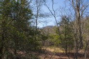
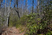
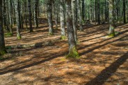
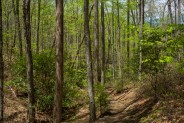
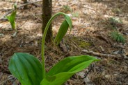
After crossing, we followed Cedar Rock Creek through the forest to a small opening with a view of our eventual destination, Cedar Rock. From here, it looked far, far away, and plenty high. We had our work cut out for us. The trail enters a small, beautiful white pine forest. The forest floor is a bed of fallen red needles that have cushioned the earth for season after season. It’s a delight to enter these stands of evergreen woods. They are found throughout Pisgah National Forest, ranging from spruce to fir to black balsam and pine. The aromas are glorious.
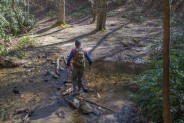
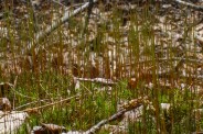
The trail crosses the creek one more time, this time without the aid of a bridge, and then begins its steady climb up the northern shoulder of Cedar Rock to Cat Gap in earnest. There are a number of switchbacks to ease the strain, but it will get your attention. The trail will change direction to decidedly eastward for about a quarter mile, then turn back to the south again. This area is a floral delight in spring as it is lined with rhododendron, dog hobble and mountain laurel, galax and ground cedar.
Approximately a mile after the last creek crossing you will come to a junction with the Cat Gap Connector Trail. Here, you can take either trail to get where you want to go. I prefer staying on the Cat Gap Loop Trail because I think the climb is just a bit more moderate. So we took a right turn to stay on the loop trail.
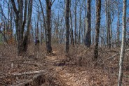
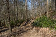
You will continue upward in a southerly direction through a forest of locust and birch, oak and poplar. It is so different during the various seasons. In the cold weather months, there are views through the leafless forest of the surrounding mountains. During the green seasons, the forest provides a canopy to shield you from the sun and wind. It is cool, full of aviary activity, and replete with the scents and perfumes of the woods.
The trail takes another easterly turn and levels off as it makes the final push to Cat Gap. The gap itself is really not much more than a joining of trails. The Cat Gap Loop comes in from the east and the west. A trail that doesn’t appear on national forest maps but heads to Burl Mountain comes to Cat Gap, and the Art Loeb Trail crosses here. Art Loeb is our next path to Cedar Rock.
Get yourself ready for some strenuous climbing while you’re resting at Cat Gap. First, the Art Loeb climbs several hundred feet, then the Cedar Rock summit trail adds another several hundred to that. The good news? The scenery is spectacular, so don’t cheat yourself by letting the required exertion deter you. Just take your time, pause for short breathers, and set your own pace.
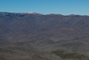
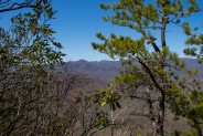
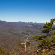
The Art Loeb Trail has white blaze markings as it climbs for ½ to ¾ mile to Sandy Gap, all the while offering a terrific view of Looking Glass Rock off to the north, and the many 5000-6000 foot peaks beyond. For the first time, we noticed those peaks were snow covered. There has been almost no snow in Western North Carolina this winter, so the white tops of Black Balsam Knob, Grassy Cove Top and Mt. Hardy were a delightful surprise. Made me yearn for the high country.
You will reach a plateau at Sandy Gap that has the best views from the trail. However, during green seasons, don’t expect to be able to see through the leafless trees. Among the many advantages of cold weather hiking are the added vista opportunities. Soon after topping this plateau, the Art Loeb Trail heads down the other side.
The summit trail to Cedar Rock has somewhat of a legend in hiking communities of being secret and not publicized. Apparently, it was a formerly maintained trail that was retired by the Forest Service because of the danger of falling from the cliffs on the pluton summit. There have been a number of deaths, or at least so I am told. Therefore, I don’t intend to break any unwritten codes by detailing exactly where the trailhead is. Having said that, though, there is information on the Internet about the trail. Just do a little search homework.
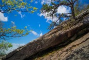
This summit trail isn’t especially long, but it is steep. It took us perhaps 15 minutes to climb to the top, with plenty of 30 second rests to suck air. Once you reach the top, though, you will know it. The summit is a long, relatively rounded cone shape with paths to the rock edges of both the east and west faces of this monolith. There is a large campsite and fire pit in the center at the capstone.
Our timing was great. That empty feeling in the pit of my stomach said that lunch was on the agenda, along with a well-deserved rest on the east face of Cedar Rock. Look for the spur paths to the granite surfaces but be very, very careful. I mentioned there hasn’t been much snow in WNC this winter, but what there has been is freezing cold even this late into March, including earlier on this morning. Even past noon, the granite still had large sheaths of ice that made for treacherous footing and an increased risk of falling. If you come up here in winter, watch very carefully for ice. It is sometimes difficult to see.
We found a great spot to sit with a view directly east and south. From here we could see the landmarks of DuPont State Forest directly in front of us. Brevard is just on the backside of Burl Mountain. Far beyond DuPont is Upstate South Carolina and the state parks that hang on the Blue Ridge Escarpment. Somewhere unseen, a few hundred feet below us, the Art Loeb Trail curls along the base of this massive granite wall.
Renourished, it was now time to explore the west face of Cedar Rock. The rock climbers love the west side. Returning to the center cone, we looked for a path to the other edge. The west side is covered with rhododendron thickets, so be prepared to sweep the low hanging branches out of your way as you follow a maze of paths toward the precipice. Look for orange ribbons hanging on the branches. Those have been placed by the climbing clubs to help lead you to strategic entry onto the west face.
I will repeat, be very, very careful. This west face is steeper and smaller. You can see pitons hammered into the rock by long-ago climbers. There was even more ice on this side, with fewer places to stand safely. In summer it might be different, but keep the ice in mind if you’re up here during cold weather months. Frankly, I didn’t feel very comfortable at all, so I snapped a few photos and got off the edge quickly before I made a mis-step.
Returning to the campsite at the central cone area, it was time to head off the south side of Cedar Rock. We noticed as we began our descent a number of blue ribbons tied to low-level branches. Perhaps a local hiking club has convinced the Forest Service to recommission this trail. Though not wide at all, it is in fairly good shape and easy to follow. We discovered a bit later why there may still be some reluctance to attract a lot of traffic to this trail.
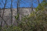
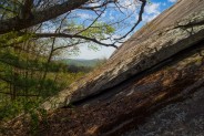
Continuing steeply down the south side, every hundred yards or so we would come to another exposed granite ledge that had to be traversed. Remember the ice issue? Fortunately, these ledges receive south-side sun, so by mid-afternoon most of the ice was now trickling water. But if you’re up here on a cold, cold early morning expect these ledges on the southeastern descent to be extremely dangerous.
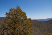
One of these ledges was especially scenic, and… what? What is that? Is that… is that a CEDAR TREE!!! YES!!! OMG!!! The smell is absolutely heavenly. Cedar Rock? Cedar tree? Made me wonder if there were hundreds on this pluton when man first came here, but I digress. I couldn’t get enough of the wonderful scent.
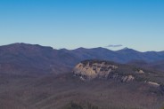
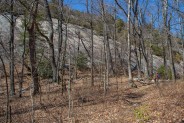
The granite ledge here curls around the southern tip and has a great view across Butter Gap to Stone Mountain, another with a large granite wall. Far in the distance behind Stone Mountain is Brushy Ridge, then further west to Nantahala National Forest.
The south side of Cedar Rock descends further than the north side climbs, so when you eventually get back to the Art Loeb Trail, you have to climb back up quite a way to return to Sandy Gap. You can continue southward to Butter Gap, but for this hike, we wanted to finish the other side of Cat Gap Loop. It is a fabulous journey north, as the Art Loeb parallels the gigantic eastern face of Cedar Rock. I am always struck by the number of narrow channels grooved into the rock by millenia upon millenia of water running down the side.
You’re about half way up the climb when you come upon a series of extremely large, extremely dead hemlocks. One in particular has a trunk with a diameter of at least four feet. At the top of the climb is a campsite on the left at the base of the granite. The pitch of the rock here is at a small enough angle that you can climb up the face on all fours a hundred feet or so, without the assist of ropes or other climbing gear. Last time I was here, I found a perch up there for lunch.
You’ll continue northward along a dry creek bed until you eventually reach the connection with the northern summit trail. From there it’s simply a matter of returning over Sandy Gap to Cat Gap.
Since we came up the west side of Cat Gap Loop, it certainly made sense to go back down the east side of the loop from Cat Gap. Look to your right for the descending northerly trail. Don’t accidently get on the unnamed trail that heads south toward Burl Mountain. You go down, down, down about a quarter mile to another major trail junction. This is where the Cat Gap Connector comes in from the west to meet the Cat Gap Loop, and also the John Rock Trail comes in from the north. We took Cat Gap Loop east.
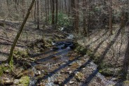
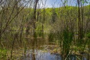
This is an absolutely beautiful forest with many poplars standing close to a hundred feet tall. This stretch of the trail is really stunning during the green season when the forest canopy allows limited light to reach the forest floor. You will cross a number of small streams tumbling down from the mountains above, some with log bridges, others with rock hops.
About half way down, you’ll pass the other end of the trail to John Rock. My companion and I gave each other an inquisitive quick glance when we passed by. The answer on both our faces said, not today.
Next is the crossing of Forest Road 5017, otherwise known as Horse Cove Road. You have a choice here. You can continue to follow Cat Gap Trail all the way back to the east end of the Wildlife Center parking, or you can take the forest road that comes out on the west end of the parking lot. The trail is obviously more scenic, following Horse Cove Creek to Davidson River, but the road is just a little bit quicker. With nearly ten miles and more than five hours on our feet, we opted for quick.
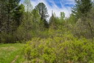
In conclusion, this is a terrific hike with outstanding views from the summit of Cedar Rock. It is hard. You will work for the opportunity to see what the ledges on Cedar Rock offer. You truly get a feel for the lay of the land in Pisgah National Forest when standing on Cedar Rock, but the trails aren’t limited to long-distance vistas. The combination of evergreen, hardwood and laurel forests as well as the many creeks and streams that rush off the mountains above make this a full-featured hike. I highly recommend it.


Update May 1, 2014: We revisited this scenic hike to Cedar Rock and even combined it with the Butter Gap and Picklesimer Fields hike to make for a nice large loop. The weather cooperated beautifully for a delightful springtime stroll among the plutons in the Davidson River area. See below for another GPS track as well as some new pictures.


The following are paid links. As an Amazon Associate I earn from qualifying purchases.
 I am Jeff Clark, founder of Internet Brothers, producer of this blog, and passionate about hiking. I live in Western NC near the Blue Ridge and Great Smoky Mountains. Pisgah and Nantahala National Forests are just out my door, so the content will focus on these areas, but let me know what you would like to see on the site.


Copyright © 2011-2023 Internet Brothers. All Rights Reserved. ISSN 2324-6057
Designed by Elegant Themes | Powered by Wordpress | Logo by Design Aspirations

