
This is a two-part hike with a short drive on a forest service road in between. Both the Case Camp Ridge Trail and the North Face Trail start on Forest Road 475B in Pisgah National Forest. The first climbs 1000 feet in 1.7 miles to the Blue Ridge Parkway near Cherry Gap at mile 416. It’s a short walk from the trail to the Cherry Cove Overlook and a close-up view of Looking Glass Rock. Return to the forest road down the same trail and drive another three miles toward Looking Glass. The North Face Trail is a 1.5 mile round trip to the northeast base of the Looking Glass pluton, a starting point for the serious rock climbers who embrace the face. These hikes occurred on Thursday, June 28, 2012 from 7:30am to 10:45am. Our plan was to take the Case Camp Ridge Trail from Forest Road 475B to the Blue Ridge Parkway and return, then drive down the forest road to Looking Glass Rock and the North Face Trail.
First Hike: Case Camp Ridge Hike Length: 3.4 miles Hike Duration: 1.75 hours
Hike Rating: Moderate to difficult Blaze: Blue Hike Configuration: Up and back
Elevation Change: 990 feet Trail Condition: Very good
Starting Point: Case Camp Ridge Trailhead on Forest Road 475B.
Trail Traffic: We encountered no other hikers on the trail.
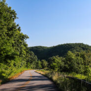
How to Get There: From Brevard, NC get on Scenic Hwy 276 west into Pisgah National Forest. After approximately nine miles, turn left onto FR 475B (Headwaters Road). Proceed to Case Ridge Gap, an additional mile down this gravel road. The beginning of the trail is marked by a set of steps across from a small parking area.
Summer has come to the Blue Ridge, and with it 90° daytime temps. With that in mind, we opted for an early start and a couple of short hikes. Hey! I thought it was supposed to be cool in the mountains.
The Case Camp Ridge Trail is one of those shortish leg-stretchers that will have you high-steppin’ as you climb 990 feet to the Blue Ridge Parkway in its 1.7 mile distance. I rate it as a moderate hike simply because it isn’t very long, but it is strenuous. So keep that in mind if you get a late start on a hot summer day. If you’re looking for a longer hike in this area of Pisgah National Forest, you may consider combining Case Camp with the Seniard Ridge Trail, a 3.5 miler that crosses Case Camp after the first quarter mile.
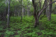
The forestry is interesting here. You will climb moderately on this blue blazed trail before passing through a forest management area. This is a shelterwood cut that was completed in 1991. Shelterwood cutting, also known as the ‘Shelterwood system’, is a silvicultural system in which overstory trees are removed in a series of cuts designed to achieve a new, even-aged stand under the shelter of remaining trees. The desired result will always be a single, or even-aged cohort of trees.
Once you clear the management area, the trail becomes more steep, and provides excellent wintertime views of the surrounding mountains. The star of the visuals is Looking Glass Rock, a geologic pluton that is an ubiquitous sight in this section of the national forest. In summer though, the forest is very dense and quite dark, especially in the morning. We were treated to shade and a wispy breeze that rewarded our decision to start early. No hint of the oppressive heat that has settled over the eastern states.
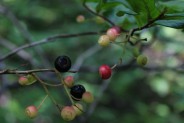
There is also a sad sight along the ridge as you climb. The effects of chestnut blight are quite evident. Chestnut stumps, a reminder of a once magnificent chestnut forest, are seen throughout the hike. The chestnut blight was accidentally introduced to North America around 1900, either through imported chestnut lumber or through imported trees. This devastating disease of the American chestnut tree caused a mass extinction in the early 1900s. Forestry management is trying to reintroduce hybrid strands of chestnut to areas of the forest. Occasionally we will see some of these “secret plantings” as we explore the ridges and summits. A hundred years later, unfortunately one legacy of the 21st century is the hemlock infestation by the wooly adelgid. Hemlocks in the Blue Ridge and Smoky Mountains are dying by the millions.
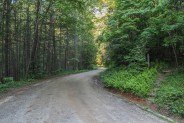
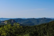
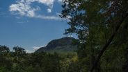
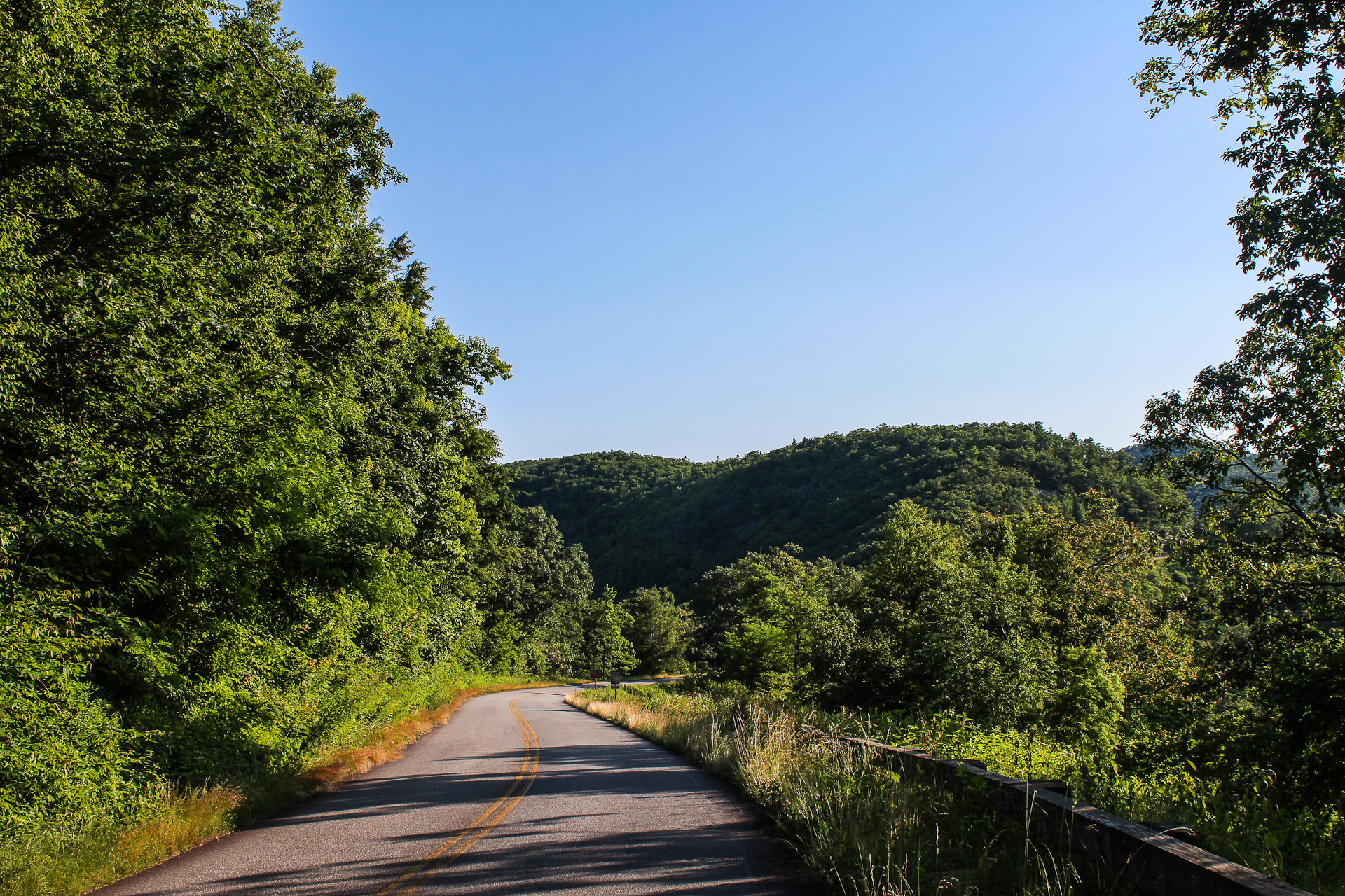
Before we knew it we popped out on the Blue Ridge Parkway, about 45 minutes. This western end of the Case Camp Ridge Trail is in mile 416. The Cherry Cove Overlook is a tenth mile to the northeast and the Log Hollow Overlook and Tunnel Gap is a half mile to the southwest. On this day, I headed to Cherry Gap to enjoy the magnificent view of the plutons. That walk is the scene in the picture at the top of this post.
Cherry Cove is one of those overlooks with a wayside panel that tells of the monarch butterfly migration. On their southward flight in September, large numbers cross the mountains at several points in this area, including Cherry Gap and Tunnel Gap. In spring they head north, breeding along the way, and depositing their eggs on milkweed. No single monarch makes the entire round trip. Offspring that hatch along the northward route either remain where they are born or journey to the northern source.
From the Cherry Cove Overlook is, I think, the best view of Looking Glass Rock on the Blue Ridge Parkway. It seems almost close enough to touch. Peer to the south from the overlook and you’re seeing the north and east face. If you have binoculars or a zoom lens, look for rock climbers and peregrine falcons. It’s on this side of Looking Glass that they share the cliff.
If you turn further to the south you will see Cedar Rock, another pluton that can be accessed on the Art Loeb Trail. All of the area of the national forest between the two monoliths is wonderful hiking, biking and camping. I read recently that with the exception of White River National Forest in Colorado, Pisgah and Nantahala in Western North Carolina are the most popular in the country. And what makes it even more exciting is, despite the large numbers of visitors, there are so many trails that we rarely see other hikers when we are out. You can enjoy the peace and solitude that the wilderness provides.
Since we had a 2nd destination, we only stayed about 20 minutes along the Parkway, then headed back down the Case Camp Trail. The descent is pretty easy, and even quicker than the climb. The trail is in very good condition with few roots and rocks to reach out and grab a toe on the way by. Don’t like those stumbles, slips and falls. Some of the leafy vegetation was spreading arms across the trail, but the maintenance volunteers do a good job of keeping the stickers and briars away.
Second Hike: North Face Hike Length: 1.5 miles Hike Duration: 1 hour
Hike Rating: Moderate Blaze: Blue Hike Configuration: Up and back
Elevation Change: 640 feet Trail Condition: Mostly very good; dangerous rocks at top
Starting Point: North Face Trailhead on Forest Road 475B.
Trail Traffic: We encountered two rock climbers on the trail.
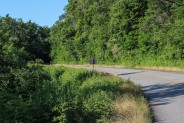
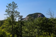
How to Get There: From Case Ridge Gap mentioned above, drive an additional three miles down Forest Road 475B. The parking area is on the left marked by red signposts. The trailhead is down several steps. You can see Looking Glass Rock as you go down the steps.
It’s about three miles down Forest Road 475B from the Case Camp Ridge Trailhead to the North Face Trailhead. Along the way you will pass FR5040 and FR5044 on the left, and FR225 on the right. You may remember FR225 from the Cove Creek hike. Keep an eye out for Looking Glass Rock through the trees. Particularly in winter, there are great close-up views on the left side of the road.
Watch for the trailhead on the left. You will know the parking by four red signs that are at the edge of the steps. There is room for about 3-4 vehicles. Walk down the steps and then about 100 feet to the trailhead. There is a signboard that will tell you about the peregrine falcon aerie, and why they close part of the north face to climbing in spring and summer while the falcons are nesting.
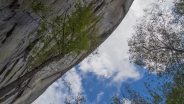
Looking Glass Rock is 3,969 feet of exposed Whiteside granite that was formed approximately 390 million years ago. Geologists refer to it as a pluton, a large dome of granitic rock that would have become a volcano had it not cooled before reaching the earth’s surface. The name Looking Glass is derived from its appearance when rainwater freezes on the surface and reflects the sun like a mirror.
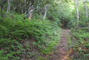
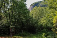
This trail is also blue blazed, and begins with a slight decline, dropping about 100 feet before climbing gradually for half a mile. Again, this is very thick forest, but the makeup is quite different. Still hardwoods and laurels, this forest is older than the managed forest on the previous trail. The trunks are wider and the trees taller. There are poplar and hickory, and rhododendron bushes as big as magnolia trees. Look also for cucumber trees with their tell-tale bright green fan-like leaves.
You will reach a small clearing where it looks like thousands have stood before trying to decide where to go next. We looked for blaze markers, but couldn’t find any, so we simply took what looked like the most straightforward route up to the base of Looking Glass. The final tenth mile is steeply uphill, about 200 feet, through a boulder field. This is breakdown from Looking Glass that makes for dicey and perilous stepping. Be very careful of ankle twists and watch your balance.
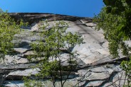
Just a couple hours later, here we stood at the base of the giant rock we had peered down upon from Cherry Cove Overlook. As you gaze straight up, you will likely notice all the pitons left by the rock climbers. If you walk a bit west, toward the north face, you can look up and see the overhang that is the falcon aerie. Heading eastward along the east face, it continues to climb steeply. I went up probably another 100 feet just to see what there was to see. It’s a sheer wall of white granite that is as beautiful as it is imposing.
It was about time for lunch, so we pulled up a couple of boulders and let our imaginations get carried away with what might strike us from above. Everything from falcon poop to pebbles tossed by hikers on the summit trail, and unfortunate climbers who said to their partner, “Watch this!” one too many times.
It’s only 15-20 minutes back to the trailhead the same way we came. On the way back we passed a couple of brave climbers. They had several hundred feet of rope, so they were planning on going up pretty high. When I was younger I had a deep-seated fear of heights. These days I would call it more of a respect. The Meanderthals motto says, “If you are gonna be dumb, you better be tough.” Well, rock climbing is one of those adventures where I’m not prepared to be dumb, much less tough.
There are five mapped trails and dozens of others along Forest Road 475B that make it a terrific hiking destination. The road itself runs from the Fish Hatchery and Wildlife Education Center to Scenic Hwy 276 just south of the Cradle of Forestry. The southern half of the road basically surrounds Looking Glass Rock. There are trails to the east, north, and west faces. The northern half of the road offers lush forested camping and hiking access to the Blue Ridge Parkway. So, if you are looking for a short hike to enhance your morning, check out FR475B in Pisgah National Forest.


It’s been awhile, so time for another visit to North Face Trail. It was just a couple days after Hurricane Irma blew through the region, so the trail bed was still covered with green leaves, a sight you don’t see very often. There were a few branches down too, but no large trees.
Saw the first leaf color of the 2017 Fall season, and had a good lunch sitting at the base of Looking Glass Rock. Here are a few new pictures I took. Please feel free to comment or ask questions below.


The following are paid links. As an Amazon Associate I earn from qualifying purchases.
 I am Jeff Clark, founder of Internet Brothers, producer of this blog, and passionate about hiking. I live in Western NC near the Blue Ridge and Great Smoky Mountains. Pisgah and Nantahala National Forests are just out my door, so the content will focus on these areas, but let me know what you would like to see on the site.


Copyright © 2011-2023 Internet Brothers. All Rights Reserved. ISSN 2324-6057
Designed by Elegant Themes | Powered by Wordpress | Logo by Design Aspirations


Great post and excellent description of Case Camp. Consider pairing it with Seniard Ridge Trail for a great morning loop. I did have a little trouble finding Seniard on BRP though. Cheers, Seeker.