
Another of the myriad of hikes along Forest Road 475 in Pisgah National Forest, this two-parter is near the Fish Hatchery and Pisgah Center for Wildlife Education. First we took a short trip up Forest Road 475B to Slick Rock Falls, then hiked to the base of Looking Glass Rock. The climbers love this area and we encountered some when we reached the base. The main hike was a little further up Forest Road 475 at the Cove Creek Group Camp. The primary feature of this 6-mile loop is Cove Creek Falls, a 50-foot slide waterfall. This is a nice flat forested hike that is ideal for families with young children. The hike occurred on Thursday, June 14, 2012 from 8:40am to 12:30pm. Our plan was to take the Slick Rock Trail to the base of Looking Glass Rock, then drive further up Forest Road 475 to the Cove Creek Group Camp. From there we would hike the loop around Cove Creek and Caney Bottom.
Hike Length: 9 miles Hike Duration: 4 hours
Hike Rating: Easy Blaze: Yellow, blue Hike Configuration: Loop
Elevation Change: 700 feet Elevation Gain: 1550 feet
Trail Condition: Mostly very good; some creek crossings; Slick Rock is rooty, and rocky.
Starting Points: Slick Rock Falls Trailhead and Cove Creek Group Camp.
Trail Traffic: We encountered no other hikers on the trails, but there were plenty of campers.
How to Get There: From Brevard, NC get on Scenic Hwy 276 west into Pisgah National Forest. Go 5.2 miles, then turn left onto Forest Road 475. After 1.5 miles (just past the Fish Hatchery), Forest Road 475B is on the right. Slick Rock Falls is about a half mile up this gravel road. Return to FR 475, continue west another mile to parking for the Cove Creek Group Camp.
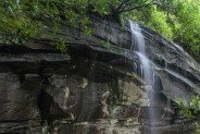
I knew when I went looking for a portable water filter that it would come in handy some day. Well, that day happened, but more about that later. We met the new guy at the Fish Hatchery on FR475 in Pisgah National Forest. From there, it’s just a hop, skip and jump to FR475B where the Slick Rock Falls Trail is. I was looking forward to seeing this new waterfall. I’ve kinda been digging exploring all the local falls lately. Transylvania County, NC is known as the “Land of Waterfalls.” Let’s just say I was underwhelmed. Slick Rock Falls is no more than 10-12 feet, was just a slow trickle on this day, and isn’t particularly attractive.
With that said, let me still convince you to hike the 1.5 mile round trip on this trail. The reason? Getting a closeup look at the base of Looking Glass Rock. The trail climbs a moderately steep 618 feet in three quarters of a mile. The waterfall, or lack thereof, is right near the parking area so you don’t have far to go for that. But keep on going uphill through the forest. The trail itself is pretty narrow, and quite rooty, then as you approach the top it gets rockier and rockier. This is breakdown from Looking Glass Rock.
It also gets more difficult to follow the trail, but just keep your eyes peeled for the yellow blaze markings on nearby trees. Regardless of whether you can discern the trail, you can still get to the base of the pluton by simply going straight uphill. The western face of Looking Glass is very popular with rock climbers, as it was on this day. There were a couple of climbers gearing up for an ascent when we reached the base of the rock. They took a moment out of their preparations to point out the route they would take up the sheer face, and where the particularly slippery and tricky places are. It’s interesting to hear an expert talk about their hobby. Me? I’ll just stick to hiking.
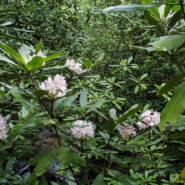
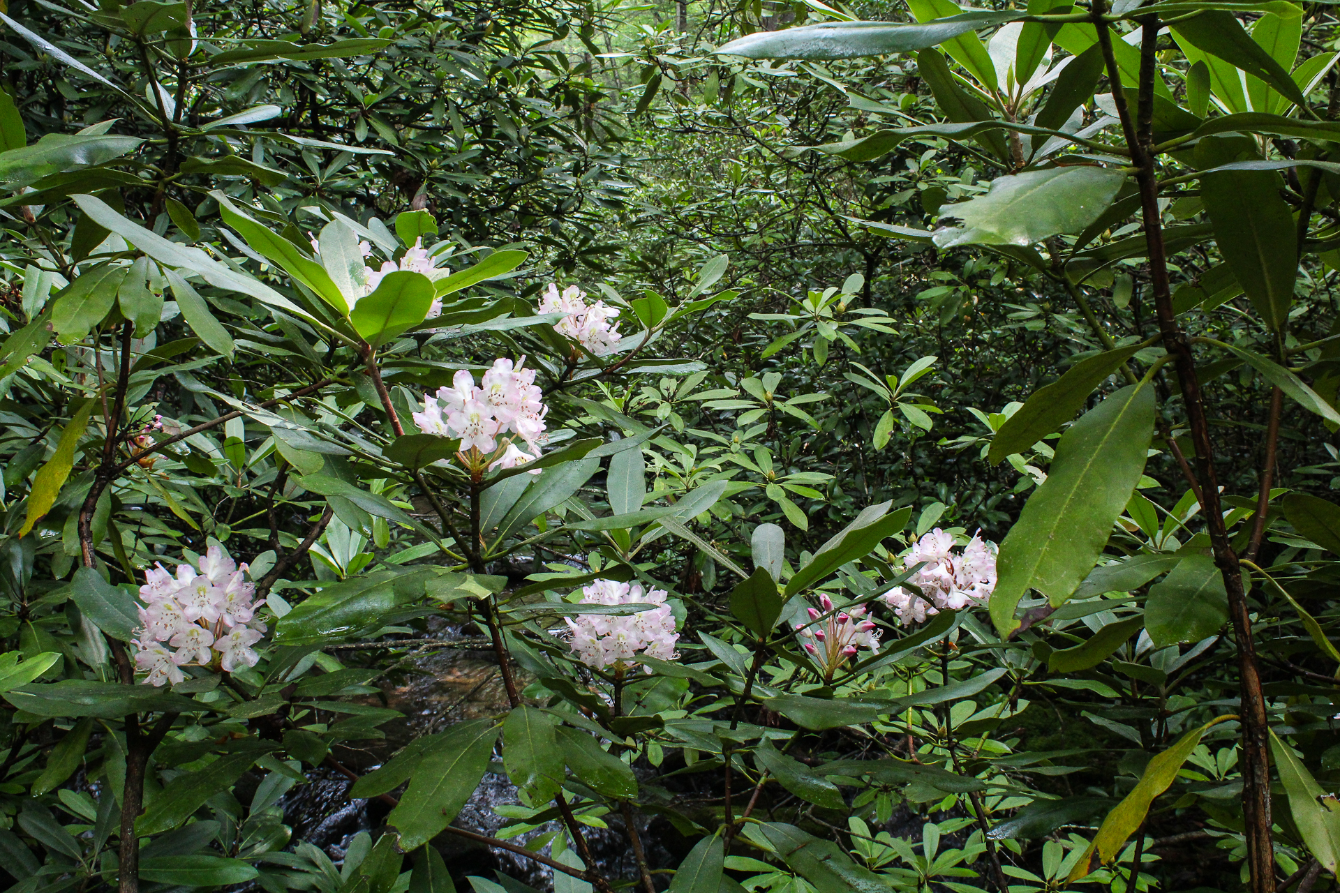
You can walk quite a ways along the base of the rock, but we still had our main hike to get to, so we headed back down the hill. We were treated to a nice floral display by the rosebay rhododendron that lined the trail. When we got back down, we took off our packs and threw them in the back. Little did I know what would be waiting for me when we got to our next destination.
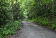
We drove down FR475B back to FR475 and headed west. It’s just about a mile to the road to the Cove Creek Group Camp. There is a gate at this road that is always locked, but there is a parking area available for day users like us. If you’re camping at the group camp, they give you a key to the gate at the ranger station.
When we opened the back of the SUV to retrieve our packs, everything was soaking wet. Uh oh! Someone’s water bladder had leaked, and it turned out to be mine. Apparently, when I put my pack back in the car, I pinched the mouthpiece open and it completely drained the entire bladder in the few short minutes it took us to drive down the road. Well flarn! First we had to dump all the water from the collection tray in the back of the vehicle, then check for any damaged electronic equipment. We really lucked out that nothing was affected, other than our spare dry clothes now being wet, and I had an empty water bladder with six miles of hiking ahead.
Not to worry though. I remembered my trusty Purificup® portable water filter. When I initially got the water filter to review, it was for just such emergencies. Because it is lightweight and compact, I carry it with me on every hike, just as I do a compass and map. This hike is along a creekside trail for nearly the entire length, so there was plenty of water available for me. For now, I filtered 10 ounces, poured it into my bladder and off we went up the forest road to the Cove Creek Group Camp.
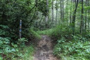
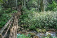
You have to walk a little less than a half mile up the forest road to get to the camp where the trailhead is. You will come to a fairly deep creek crossing, but don’t wade through, that is unless you just feel like getting your boots all wet. If you look to the right of the road there is a short trail for walkers that leads to a bridge over the creek. The road crossing is for the vehicles driving to the camp. Not far past this crossing you will see the large clearing that is the group camp, but keep a lookout for the blue blazes of the Caney Bottom Trailhead on the left just before you get to the camp. The trail skirts the camp through the woods so you don’t have to walk through and disturb the campers.
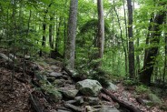
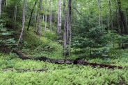
This is totally typical Pisgah Forest lower elevation hiking. The forest is hardwoods and laurels, and creeks and streams abound. You almost always hear the sound of rushing water. This hike has at least a dozen creek crossings, usually over logs laid across the stream. The trail climbs only 500 feet in its 3-mile length, so it seems nearly flat. This is definitely family friendly; easy for all ages, young and senior. Half a mile up, the Caney Bottom Trail meets the Cove Creek Trail heading off to the left and the blaze changes to yellow. Then another quarter mile after that is a junction with the Cove Creek Falls Trail to the right.
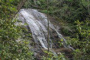
Be sure to take this short spur trail down to the waterfall. It is one of the highlights of the trip. The waterfall itself is of the slide variety, dropping about 50 feet in total. It’s kinda hard to get any really clear views of the falls because of the vegetation between it and the trail. Just keep going down the trail and eventually you will find some satisfactory viewing points. The climb back up is the steepest and hardest part of the entire hike.
Once you get back to the Cove Creek Trail, it’s a nice leisurely stroll through the forest. There aren’t any landmarks. There are no vistas or outcroppings. Just lush, beautiful deciduous forest as far as you can see. Throw in the creek sounds and it’s a pleasant, peaceful setting.
It’s hard to see when the leaves are out, but about a mile past the Cove Creek Falls there is a meadow on the left about a hundred yards off the trail. It’s easy to find in winter because you can see through the trees. As we discovered, not so much in June. We never did see it as we walked past. There is a series of campsites along the trail that mark the approximate location of the meadow, but we simply couldn’t see it this time of year. So we pressed onward.
About 2.5 miles from the original trailhead, the Cove Creek Trail rejoins the Caney Bottom Trail and both continue northward until they meet FR225. This was the end of our hike, but there are several options if you wish to extend your hike. You can take the forest road east a little ways and join a trail that goes to Bennett Knob and then on to the Blue Ridge Parkway. You can also keep on FR225 about a half mile until it meets FR475B — yes that 475B, the same one that went to Slick Rock Falls. At this point it is several miles further into the forest. You can also turn left or west on FR225 and go to the meadow I was talking about above.
By this time we were all ready for lunch, so we went back where we came from, to one of the campsites, and pulled up a big log. As we were enjoying our nourishment and the surroundings a couple mountain bikers rode by, the only other folks we saw on the trail all day.
Just past the campsite is the split of Cove Creek Trail and Caney Bottom Trail, so this time we took Caney Bottom for the return. The trail follows Caney Bottom Creek nearly the full way back. This trail is not quite as wide as Cove Creek because it is for hikers only. It doesn’t need to be as wide to accomodate the mountain bikes. There is also a more dense ground cover along the trail — abundant ground cedar and galax, as well as pockets of ferns that scream “green,” “green.”
Watch your step on all the creek crossings. The log bridges are slick with the moisture that is ubiquitous in this near rain forest environment. The babbling and rushing sounds of Caney Bottom are your constant companion on the delightful trek through the woods. I took another opportunity to refill my Purificup.
You will come upon the northern end of the Cove Creek Group Camp, but don’t be tempted to walk right through the middle of the camp. It simply isn’t polite trail etiquette. Yes, you will have to walk farther on the trail to circle the camp, but you won’t have anyone shooting you a dirty look, or worse. Perhaps if you want to walk through the camp you can take this hike in the winter when there won’t be anybody there.
The final half mile after the camp is back on the forest road to the car. The creek rushes pretty hard through this stretch as it makes its way to a meeting with Davidson River at the parking area.
The Cove Creek/Caney Bootom loop is an easy family-friendly walk through forest that is characteristic in Western North Carolina. Because it’s nearly flat, you don’t have to be in great shape to enjoy the sights and sounds, but remember it is six miles. If that seems a little daunting to you, simply stop and turnaround at any point. I recommend this hike for any season, and for children and the elderly alike.
While you’re in the area, you may as well take in the Slick Rock Falls Trail too. It will only add another 45 minutes to your day, and you can tell everyone you stood where the climbers converge at the base of Looking Glass Rock.


The following are paid links. As an Amazon Associate I earn from qualifying purchases.
 I am Jeff Clark, founder of Internet Brothers, producer of this blog, and passionate about hiking. I live in Western NC near the Blue Ridge and Great Smoky Mountains. Pisgah and Nantahala National Forests are just out my door, so the content will focus on these areas, but let me know what you would like to see on the site.


Copyright © 2011-2023 Internet Brothers. All Rights Reserved. ISSN 2324-6057
Designed by Elegant Themes | Powered by Wordpress | Logo by Design Aspirations

