
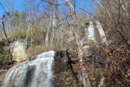
Falls Creek Falls is a double cascade in the northeast corner of the Mountain Bridge Wilderness in upstate South Carolina that free falls more than a hundred feet. In winter there is a distant view of the top of the falls from 800 feet below at the trailhead on Falls Creek Rd. From the falls, Hospital Rock Trail climbs Standingstone Mountain along Falls Creek for ridge top views of the surrounding wilderness area. This very difficult and strenuous trail continues along the ridge and over several streams to the small cave in Hospital Rock, eventually ending at the headquarters for Jones Gap State Park. This hike occurred on Thursday, February 23, 2012 from 9:40am to 3:25pm. The plan was to take the Falls Creek Trail to Falls Creek Falls, then continue up and over the ridge on the Hospital Rock Trail. We would then decide whether to turn back the way we came, or continue the loop to Hospital Rock and on to the Jones Gap State Park Headquarters.
Hike Length: 11.8 miles Hike Duration: 5.75 hours
Hike Rating: Very difficult (extremely strenuous) Blaze: Purple, orange
Elevation Change: 1680 feet Elevation Gain: 3330 feet Hike Configuration: Loop
Trail Condition: Extremely rugged terrain, rocky, creek crossings
Starting Point: Trailhead is on Falls Creek Rd. off Duckworth Rd. near Jones Gap.
Trail Traffic: There were no other hikers on the trails on this Thursday.
How to Get There: From SC take Hwy 11 (Camp Creek Road) to River Falls Road and follow the signs to Jones Gap. From NC take Hwy 25 to Camp Creek Road. It’s 6 miles to River Falls Road, then follow the signs to Jones Gap. Turn right on Duckworth Road, then right on Falls Creek Rd. past Palmetto Bible Camp. The trailhead is on the left.
This is a hard hike. I wanted to get that out there right up front so there won’t be any confusion. This is a hard hike. There. I said it again. I spent a good part of the day gasping for air — and when I wasn’t doing that my hips and knees were screaming at me.
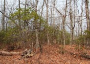
Having said that, this is also a very scenic hike. My hiking partners and I have been spending quite a bit of time in Mountain Bridge Wilderness in upstate South Carolina in recent weeks and we’ve yet to be disappointed. It is a beautiful, albeit rugged area. Even the roads to the trailheads are picturesque.
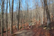
The purple blazed Falls Creek Trail starts a steep ascent right from the git-go. The trail is wide and well-groomed as it winds its way through hardwood forest. It’s 1.3 miles and 800 feet up to the falls. That distance is traversed in two very steep climbs with a short break in the middle through a boulder field. There’s a mansion that sits atop a nearby hill that we used as a status landmark to determine how quickly we were climbing. It didn’t take long for us to reach the same elevation and go beyond. Once we were looking down on the house we could see a large parking area. Perhaps this is a bed and breakfast.
Some of the boulders along the trail are nearly as big as that house. Most likely left from glacial activity many moons ago, they fill the forest, and make for pleasant spots for nourishment breaks. One can only imagine the bears and other hibernating creatures who may inhabit the cave-like cutouts beneath the rock. As we passed the boulder field and began the 2nd climb, the trail got a little rockier and began a series of switchbacks through the steep terrain. Some of our steps required hands and feet to navigate the steepness.
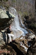
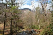
We could hear the rushing of water as we climbed the mountain — first from Falls Creek tumbling downhill — getting louder and louder as we approached the falls. Then finally Falls Creek Falls came into view. A spur trail goes part way up beside the falls so you can get a view looking down at the lower cascade, but I suspect this view is blocked by trees in seasons when the leaves are out. The main trail is craggy as it scrambles downhill to the base of the falls.
 Falls Creek Falls is a double free-fall cascade that drops a total of more than 100 feet. The upper cascade is the tallest. When you reach the base of the lower cascade you are literally right at the falls. There is a persistent, and refreshing, mist that surrounds you. Be sure to check your camera lens for spots after capturing the beauty of this merger of rock and water.
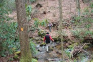
The creek crossing across the base of the falls is extremely treacherous. There are many, many uneven and unstable rocks that are covered with moss and always wet. This is an accident just waiting to happen. Trekking poles or some other means of balance assist are highly recommended. In warm weather months when the water isn’t ice cold, I would even suggest removing your shoes and crossing through the water to avoid the very slippery rocks.
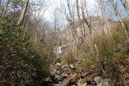
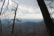
On the other side of the falls the blaze markings change to orange as the Hospital Rock Trail begins, or ends, depending on the direction you take this loop. You might want to rest for a bit at the falls because once you hit Hospital Rock Trail it’s climb again, and climb some more. The trail goes steeply up to the level of the waterfall and beyond as it follows the path of Falls Creek northward. Occasionally there are views through the trees to the west of the Caesar’s Head ridge and the Blue Ridge Escarpment. Near the creek there are canopies of rhododendron and the creek itself has several slide falls as it spills along the granite.
There are also various decision points along the way. We stopped a few times to admire the view into the distance while we decided if we had enough energy to continue forward and go all the way around the loop, or if we wanted to turn back and cross that dangerous creek again. Despite our growing fatigue we continued to press ever forward.
About 3/4 mile past the falls the trail makes a hard cut to the west as it follows the ridge that climbs Standingstone Mountain. There’s no relief for the weary as it continues its relentless climb eventually reaching the ridge summit 2.3 miles and 900 feet above the falls. There is a trail marker, but it doesn’t say where the weak, blind northward trail goes. Presumably it is on to Standingstone, but we wanted to continue west on the Hospital Rock Trail.
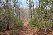
For the next half mile the trail parallels a creek that is not named on the Mountain Bridge Wilderness map you can get from the state park. The trail goes back and forth across the creek several times — even follows in the creek at one point for a hundred feet or so — as it gradually marches downhill. Then, just when you think all the hard stuff is over, another ridge appears and it’s quickly and steeply back uphill all the elevation that was lost along the unnamed creek. Pant. Pant. Wheeze. This is hard.
 By now I was becoming acutely fatigued and falling behind my companions. It was definitely time for some energy. So I plopped down in the middle of the trail and ate a granola bar, then 1/4 mile later I did the same thing again. The trail here was quite wide as it appeared to be a former logging road. Finally the trail reached the ridgeline summit again at the 5 mile mark. Then, just when I thought I would get a break, it started steeply downhill. No more gradual descent like along unnamed creek, the trail was now going steeply in a downward direction. Wobbly legs.
In a few minutes I caught up with my buddies waiting at the trail junction for the Cleveland Connector to the Greenville YMCA Camp. I said I was sorry for not keeping up, but I needed more food, and I strongly suggested we stop and eat our lunch right there rather than waiting until Hospital Rock. I don’t know if it was the refreshment or the rest, probably some of both, but when we put the packs back on I had 10 more horsepower.
And I sure needed it because the trail continued very steeply down for the next mile… very hard on the legs. We wondered up top if maybe this hike is a little easier if you start at the Hospital Rock end. Perhaps it wouldn’t be quite as steep going up in a clockwise direction instead of starting at the falls end. Well, this side of the loop is every bit as steep as the Falls Creek Trail. As I said at the beginning, this hike is hard, no matter how you slice it. Much of the trail was still covered with dried leaves, so that made footing even more difficult on the steep downward passage. In many areas the trail edge was very soft and the dirt would collapse beneath our feet if we stepped too close to the edge.
We reached another waterfall, this one again not mentioned on our trail map. Probably 50 feet in height, it sits back a hundred feet from the crossing. We took a break to wash the sweat from our faces in the cold, crisp mountain stream. Then back at it. On this side of the ridge there are a number of cliffs of gneiss as they call it on the escarpment. The trail would skirt the cliffs, but still have to negotiate the same elevation drop.
The next landmark was a house-sized series of boulders with an overhang and a small cave. We couldn’t decide if this was Hospital Rock or if one of the gneiss was passed was Hospital Rock. Regardless, we stopped again to rest our weary legs before making the final push.
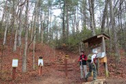
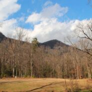
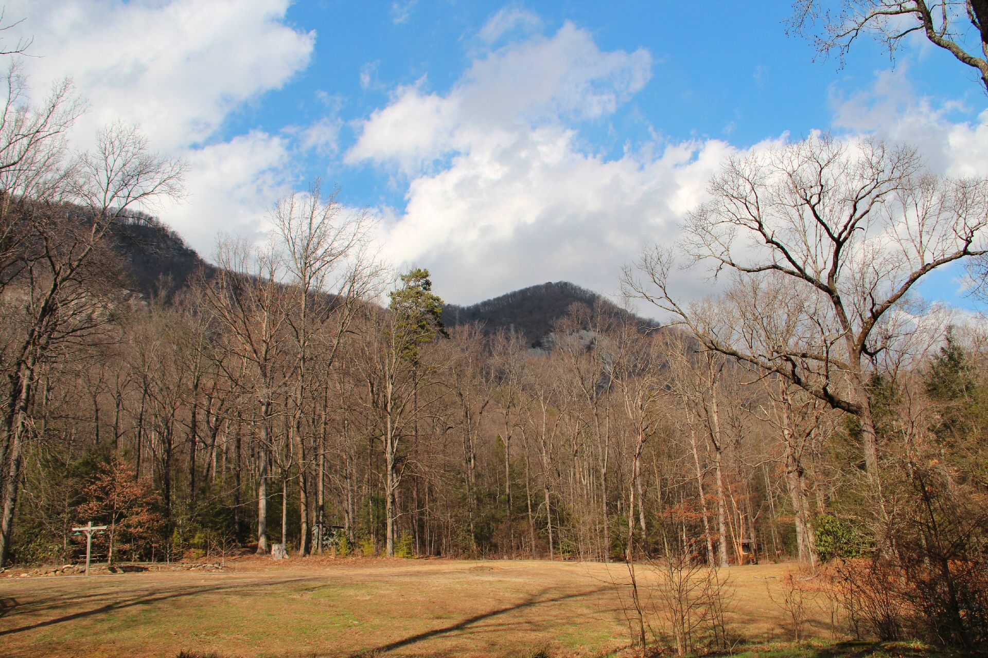
It’s perhaps one final mile from Hospital Rock to the trailhead. We knew we were approaching the end because there was a series of primitive campsites along the trail. Then the trail spilled out at the entrance to Jones Gap State Park. That’s the photo at the top of this post. There was the familiar Saluda River we had hiked just a few short weeks before. We were all relieved to reach this point, but…
To get back to the Falls Creek trailhead parking on Falls Creek Rd. we now had to walk 3.2 miles on paved road. First, we hoofed it on Jones Gap Road, then took a left on Duckworth and another left on Falls Creek, finally getting back to the car about 55 minutes later. Some people will take two cars when they do this loop hike, leaving one at Jones Gap and the other at Falls Creek. Then you don’t have to do the road walk. It’s up to you. If you don’t live far away and don’t mind the extra gas, two cars would save some wear and tear at the end of a very hard hike.
Depending on your stamina and fitness, you may want to only visit portions of this hike. It was definitely right at the limit of my fitness. Falls Creek Falls is very nice and can been enjoyed with a 2.6 mile round trip. Hospital Rock and the unnamed falls on the other end aren’t as remarkable, but the climb through the forest to get there would be enjoyable as well. However, if you are fit and hearty and want to test your endurance, the Falls Creek/Hospital Rock loop hike may be just what you’re looking for.
Update: July 28, 2014: It needs to be noted that the Hospital Rock Trail is presently closed because of a landslide that occurred in the area. South Carolina State Park rangers have closed this trail for safety reasons. When further updates are available, I will post here.
Update: June 9, 2015: Word about town is that the Hospital Rock Trail has now reopened.


The following are paid links. As an Amazon Associate I earn from qualifying purchases.
 I am Jeff Clark, founder of Internet Brothers, producer of this blog, and passionate about hiking. I live in Western NC near the Blue Ridge and Great Smoky Mountains. Pisgah and Nantahala National Forests are just out my door, so the content will focus on these areas, but let me know what you would like to see on the site.


Copyright © 2011-2023 Internet Brothers. All Rights Reserved. ISSN 2324-6057
Designed by Elegant Themes | Powered by Wordpress | Logo by Design Aspirations
Great photos. Thanks for sharing. I found this searching for info on the Hospital Rock trail. We hiked up this weekend, starting at Jones Gap towards Hospital Rock and on to the YMCA Camp (came down via Rainbow Falls) and I’m trying to figure out how we missed Falls Creek Falls. Definitely a hard hike.
Hi Sarah. Falls Creek Falls is way east of Rainbow Falls. In fact, it is outside the boundary of Jones Gap State Park. It’s considered part of Mountain Bridge Wilderness.
I noticed that same house from the falls and wow what a view they must have. I can’t locate it on the map so I doubt it to be a bed and breakfast, just some people with one of the best views money can buy.