
Montreat is a small community just north of Black Mountain, NC with a world renowned conference center, a college, and best for us, 20 miles of hiking trails that rival those in nearby Pisgah National Forest for quality and scenery. In particular, the Greybeard Trail is an exceptional workout that climbs more than 2300 feet to the summit of Greybeard Mountain on the Blue Ridge Escarpment where there are stunning views of Mt. Mitchell and its other 6000′ brethren. The trails are contained within private conservation land known as Boggs Memorial Wilderness and hiking is open to the public. This hike occurred on Thursday, September 29, 2011 from 9:45am to about 3:45pm. The plan was to take the Greybeard Trail from Montreat to the summit of Greybeard Mountain with stops at Greybeard Falls and Walker’s Knob along the way. We would then make a loop hike by descending along the West Ridge Trail to the junction with Big Piney Ridge Trail and a return to Montreat.
Hike Length: 8.9 miles Hike Duration: 6 hours
Hike Rating: Difficult, strenuous Blaze: Blue, grey, orange
Elevation Gain: 2800 feet Elevation Change: 2338 feet Hike Configuration: Loop
Trail Condition: Very good, Big Piney Ridge is extremely steep
Starting Point: The Greybeard trailhead is at the end of Greybeard Trail Rd. in Montreat
Trail Traffic: We encountered two other solo hikers, one up, one down
How to Get There: From Interstate 40, take NC Highway 9 at Black Mountain and go three miles to Montreat. Highway 9 becomes Greybeard Trail Rd. for another mile. The road ends at the Greybeard trailhead, about 100 yards after turning to gravel.
View Greybeard, West Ridge, and Big Piney Ridge Trails, Montreat in a larger map
The trail system in Montreat is on private land owned by the Montreat Conference Center and maintained by the Montreat Cottagers, the Mountain Retreat Association, and the Montreat Landcare Committee. Montreat has 13 hiking trails totaling more than 20 miles. Of Montreat’s 4,000 acres, 2,500 acres are dedicated to wilderness and are entered in the North Carolina Registry of Natural Heritage Areas. It goes without saying that we should all leave this beautiful, pristine wilderness as we found it. We are invited guests on this land, and should behave as such, so the public will always be welcome. Be sure to follow the Montreat trail system rules and regulations.
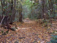
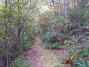
The blue blazed Greybeard Trail starts off nice right off the bat with a beautiful wooden bridge over Slaty Branch. On this day in late September there was a covering of yellow leaves on the bridge and foot path that led the way into the hardwood forest. It’s a long climb up Greybeard Mountain and the up began right away, but it was gradual and not immediately tiring. The trail follows and crosses Flat Creek several times through a very quiet forest with lots of songbirds and squirrels. The forest floor is covered with fern and galax, and there are plentiful rhododendron and laurel thickets throughout. There are signs around warning of black bears, but we ran into another hiker who was coming down who said he had never seen a bear in four years of hiking these trails. About a mile up the trail there is a tastefully done bronze plaque in a rock dedicated to Lou and Wade Boggs, designating this area as the Boggs Memorial Wilderness.
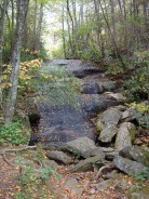
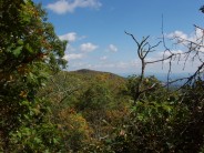
1.5 miles into the climb we reached a plateau where the trail entered a series of long, relatively flat switchbacks. This is Pot Cove Gap. Here was our first opportunity to see a view of the surrounding Blue Ridge. There is a break in the trees that enables a long distance view to the east of the Iron Mountain Ridge. The switchbacks go on for nearly a mile, but it was a nice break from the earlier climbing, and from the steeper climbing that laid ahead. At the last switchback turn is a very short spur trail to Greybeard Falls, a small slide-type waterfall that didn’t have much water on this autumn day.
Not much further up is another spur trail, this one perhaps 300 yards, that goes to the old Trestle Road and Old Mount Mitchell Toll Road. The only trestle we saw was partially buried in Flat Creek. There isn’t much to see, and you may want to skip this unless you are a mountain biker. Trestle Road is a good bike trail and biking is not allowed on Greybeard Trail.
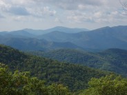
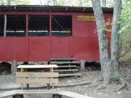
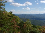
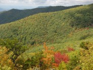
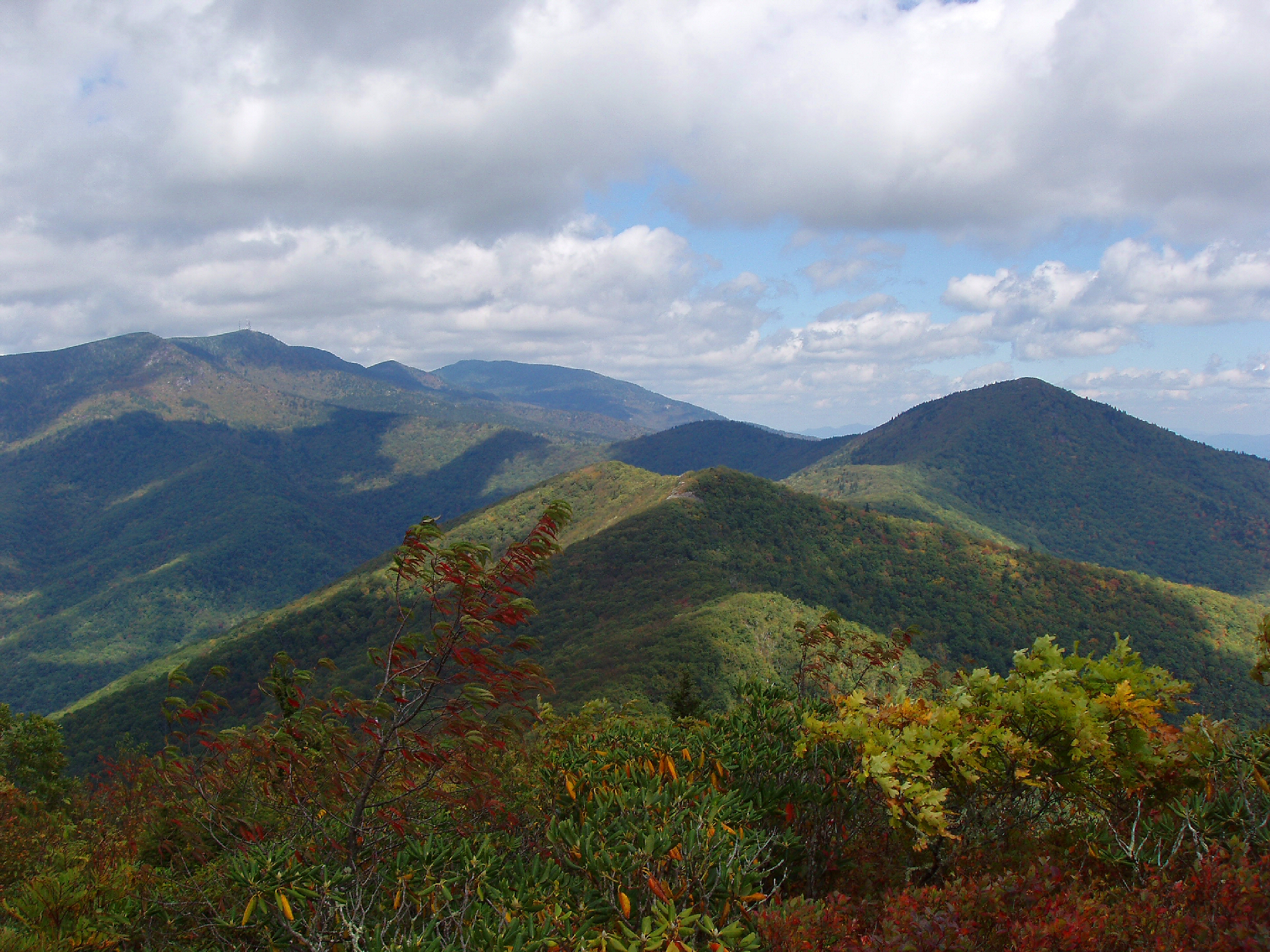
 Greybeard Trail begins climbing again and reaches Walker’s Knob Shelter, an excellent overnight camp spot that was built in 1984. There is room for large groups in the shelter, and there is a large fire ring with benches, and even a grill. Be sure to make reservations back in Montreat at the Nature Center. The Walker’s Knob spur trail is 0.2 mile to one of the best views on the hike. From Walker’s Knob we could see our eventual destination, Greybeard Mountain. We could also see the downward side of the loop, the West Ridge Trail, a long roller coaster descent. To the south is the town of Black Mountain, and to the east the beautiful and unforgettable Blue Ridge. No matter how many times I see ridge after ridge lined up as far as the eye can see, I still love the compelling beauty of these mountains. It’s why I continue to make my home here. There was a nice sprinkling of red, orange and yellow within the forest, though peak leaf peeping is still a couple weeks away. There is a rock outcropping on Walker’s Knob and that’s where we had our lunch. We reached this spot in two hours-15 minutes.
Back to the shelter, and then another 1.25 miles all uphill to the false summit of Greybeard Mountain. Here was a wooden fence built like a cattle corral, and the junction of three trails. The reason for the bizarre fencing is the Asheville Watershed. The watershed is to the west and runs into the North Fork Reservoir. They really don’t want you hiking or otherwise messing around in the watershed, so just stay on the trails and you’ll be good. To the left, or southwest, is the West Ridge Trail (our eventual descent path), and to the right (north) is the spur trail to the summit of Greybeard Mountain.
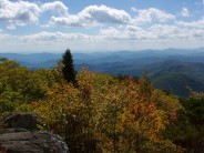
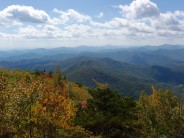
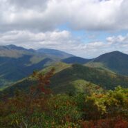
It’s only 0.3 mile to the summit and the first two-tenths is flat, but the last tenth mile climbs another 200 feet. After all the climbing we had already done, this was a bit of a bummer, but it was definitely worth it. The summit of Greybeard, at 5408 feet, offered our first look to the north. There before us was the massive expanse of Mount Mitchell, the tallest mountain east of the Mississippi at over 6600 feet. That’s the photo at the top of this post. We could see the state park that surrounds the mountain as well as the other 6000′ peaks in the area like Blackstock Knob, Potato Knob, Mt. Gibbes, and Clingmans Peak with its three radio towers. To the east is another beautiful view of the Blue Ridge Escarpment.
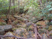
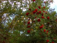
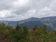
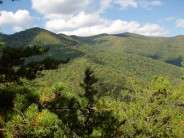
 By now it was 1:30 in the afternoon and there was a warning sign back at the false summit that said not to begin the West Ridge Trail late in the day. It is very rugged country, rocky, with lots of roller coaster ups and downs across fins and outcroppings. We would later learn that sign is excellent advice. You would definitely not want to be on this trail, or the Big Piney Ridge Trail, after dark. Meanwhile, the grey blazed West Ridge Trail is very beautiful and loads of fun. Through the forest of oak and maple, chestnuts and hickory, and abundant mountain ash we could see the Craggy Mountains on the west side of the trail, and the ridge we climbed on the east. The ridge the trail follows is known as Seven Sisters Ridge, forms the Buncombe/McDowell county line, and is part of the Black Mountain Range. We passed one other hiker and her dog, a student at Montreat College. No, not her dog silly.
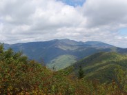
About half way down, the trail goes across a large outcrop known as Rattlesnake Rock. My companion and I, thinking like Meanderthals, didn’t want to know how it got its name, but be assured we kept one eye toward the ground and our ears peeled while we stopped to take in the stunning sights. The view here is similar to that on Walker’s Knob, just several hundred feet lower. It was about this point we began noticing downed barbed wire along the trail for the next half mile or so. This is no doubt left from fences that were there to protect the watershed. Just beware the barbed wire is there. It is a tripping hazard.
After 2.5 miles the West Ridge Trail reaches a junction with Big Piney Ridge Trail, the way back to the beginning. Here the trail blaze changes to orange. Not far down Big Piney is a nice view back up at Greybeard Mountain, and down to Montreat. It was interesting to see how far we had come down, and how much farther down we still had to go. What sticks out most with me is steep, steep, steep. Between our soreness and whining, my friend and I were debating whether we would rather go down this stretch, or climb up; in other words, do the loop the opposite direction. Neither of us are spring chickens, and the miles were taking their toll. He argued he would rather go up, because the really steep downhill was very hard on his knees. My thinking concluded we were going the right direction — trying to go up this slope would burn the lungs. We were both right, and wrong, but before we knew it we were back to Greybeard Trail Rd.
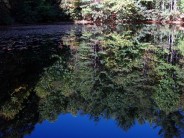
It’s about a quarter mile up the road to the trailhead parking area. On the other side of the street from the parking is the Walk C. Jones III Wildlife Sanctuary. There is a trail that goes into the sanctuary and around the Montreat Reservoir. The reservoir, really more like a pond, was perfectly still and reflecting the surrounding trees and sky. There were yellow leaves floating on the surface, making for a tranquil and relaxing setting after six hours of hiking. On the far side of the reservoir is a large gazebo, called the Environmental Education Pavilion. It is big enough to seat probably two dozen folks in a circle for a little kumbaya.
My friend and hiking companion introduced me to Montreat. Even though I have lived in western North Carolina for six years, it had escaped my radar. He knew nothing about it either, only what he had read in Joe Miller’s 100 Classic Hikes in North Carolina. I’m glad he found it, and thanks to Joe Miller. The Greybeard Trail is an excellent hike that gave us a good workout, enjoyable creeks and forest, and beautiful scenic vistas. Thanks to the people of Montreat who willingly share this beauty with us, and with you.

The following are paid links. As an Amazon Associate I earn from qualifying purchases.
 I am Jeff Clark, founder of Internet Brothers, producer of this blog, and passionate about hiking. I live in Western NC near the Blue Ridge and Great Smoky Mountains. Pisgah and Nantahala National Forests are just out my door, so the content will focus on these areas, but let me know what you would like to see on the site.


Copyright © 2011-2023 Internet Brothers. All Rights Reserved. ISSN 2324-6057
Designed by Elegant Themes | Powered by Wordpress | Logo by Design Aspirations
Beautiful trail and wonderful images. I love the name as well!
DSD
Thanks for the excellent write-up and pictures. I’ve done some of the shorter trails at Montreat, and have often wondered about this one. Sounds like a real expedition!
Nice write up! I ran/hiked this exact loop yesterday. . . its a little grown up on west ridge in the summer but greybeard is always pleasant!
Went up and back on Greybeard last week, and then did the whole circuit (Greybeard/West Ridge/Big Piney) yesterday. Fantastic! Trails well-marked, including apocalyptic warnings for West Ridge. The reverse circuit, starting w/Big Piney Ridge, would be a stout challenge, and appears that it would supersede Old Butt Knob trail as an uphill workout. Thanks so much for the excellent descriptions and pics. Very helpful, and encouraging!!!
Long overdue thank you for mentioning this trail. It’s only mentioned once in 5 of my NC hiking books, and I never knew about it until this post. Hiked it twice this winter already, taking friends each time. It really is a perfect day loop, and easy access from the interstate as well.
Great site. A note about the map at this site. I hiked West Ridge last summer. I am pretty sure the Pig Piney Ridge Trail actually is on the next ridge to the south. If hiking up this way, find the trailhead on the Montreat Trail Map. If you are interested, there is another Montreat trail up to West Ridge even further to the south. It has a nice rock outcropping but the trailhead is further from Greaybeard making the loop a little longer.
Thanks for the tip David.
I just did this loop last week, though starting with the trail up to Rattlesnake rock instead. I can’t believe that in years of hiking Montreat I hadn’t done the West Ridge trail, it was lovely! As a side note, I understand why there are a couple places around here with rattlesnake in the name…