
Formal protection of the Linville Gorge began in 1952, when the land was purchased with funds donated by John D. Rockefeller, Jr. When the Wilderness Act was approved by Congress and signed into law by President Johnson in 1964, the Linville Gorge Wilderness became one of the first formally designated Wilderness areas of the new National Wilderness Preservation System. Wonderful news for future generations, as this wilderness that covers more than 12,000 acres will remain in the same pristine condition for centuries to come. The area is filled with trails that wind through thickets of mountain laurel and descend into Linville Gorge, one of the most rugged and scenic gorges in the east. It is fully 2,000 feet from the gorge’s rim to the Linville River below. This hike occurred on October 21, 2010 beginning at 8:30AM and ending about 2:00PM. The plan was to climb Sitting Bear Mountain on the east rim in the north gorge, then drive south on FR 210 to the Tablerock area and take the Shortoff Trail through The Chimneys and on to the North Carolina Wall and The Amphitheater.
Hike Length: 5 miles Hike Duration: 5.5 hours
Hike Rating: Moderate Blaze: No blaze, wilderness
Elevation Gain: 800 feet Hike Configuration: Up and back, Out and back
Trail Condition: Scrambing rock Starting Point: Sitting Bear Trailhead
Trail Traffic: We saw two other hikers on the trail to Sitting Bear Mountain. The Chimneys hike is very popular. I would estimate there were two dozen other hikers out on this day.
How to Get There: This hike is on the east rim. From Marion, NC take US 221 north to the intersection of NC 183 at Linville Falls. Turn right on NC 183 and continue to NC 181. Turn right and go south on NC 181 and continue three miles to Forest Service Road 210 (Gingercake Road). Turn right on FR 210. At the first fork, turn left and continue through the Gingercake Acres subdivision. Go two miles to the first parking area, for Sitting Bear and Devil’s Hole. The west rim has a separate and different access.
View Sitting Bear Mountain and Shortoff Trail, Linville Gorge Wilderness in a larger map
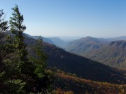
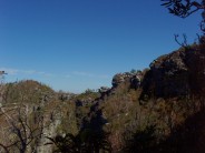
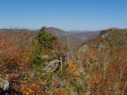
It’s nearly a 2 1/2 hour drive from our homes to the Linville Gorge, so we got a very early start on this day. We arrived at the Sitting Bear Mountain trailhead at about 8:30AM. The trail to the summit is not long, it’s only about a mile round trip, but the last half of the climb is some of the steepest terrain I have ever hiked on. Hands were required on this dirt trail. On this particular day we were also faced with a steady 25 mph wind with gusts at 40. The summit of Sitting Bear is a very exposed rock outcrop with a several hundred foot drop on the gorge side, so that wind definitely got our attention. But the view south down gorge is stupendous. You can see each of the mountains on the east rim lined up; Hawksbill, Table Rock, and Shortoff, with the Chimneys in between. There is also a beautiful view north of Pisgah National Forest, and the west rim across the gorge.
On the way back down, we took a little diversion on the Devil’s Hole Trail. It heads down into the gorge and we wanted to see how steep is was for a potential future hike. We went about 1/4 mile down, then came back up.
It is approximately three miles on FR 210 south to the connecting road to Table Rock, then another 0.7 mile up the very steep, but partially paved, Tablerock Road. There is a nice picnic and parking area at the top of the road, and trailheads to Table Rock Mountain (another very nice hike in itself) and down gorge on the Shortoff Trail (also part of the Mountains to the Sea Trail).
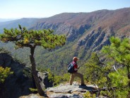
 The first thing I noticed on the Shortoff Trail is that it is a very narrow ridge with steep drops on both sides, and boy was it windy.
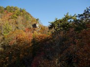
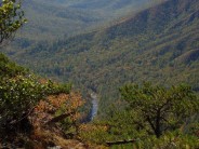
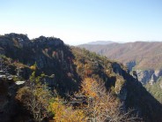
It’s about 15-20 minutes to a series of bluffs where we could get right on the edge, like Polaroid Point, and see the Linville River way below, and view the two Tablerock Mountains behind us. There is a deep drop in the trail, then scrambling up and over rock, and squeezing through slots to get to the area known as The Chimneys. This is an extremely popular area with experienced rock and rope climbers. On the day we were there, they were conducting a climbing school for college students. The wind was making just about everyone balk at scaling 40′ to the top. I couldn’t blame them.
It had been recommended to us, by someone who had been on this trail before, that we look for the side-trail to the North Carolina Wall and The Amphitheater. Supposedly there was a cairn of white quartz setup on the right side of the trail about 10 minutes past The Chimneys that marked access to these features. We were told if the Shortoff Trail starts descending steeply into Chimney Gap that we have gone too far. Well, we found the cairn and started down the side of the gorge. This trail descended quite steeply too.
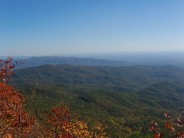
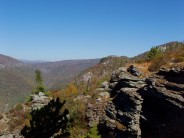
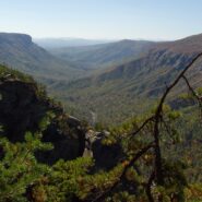
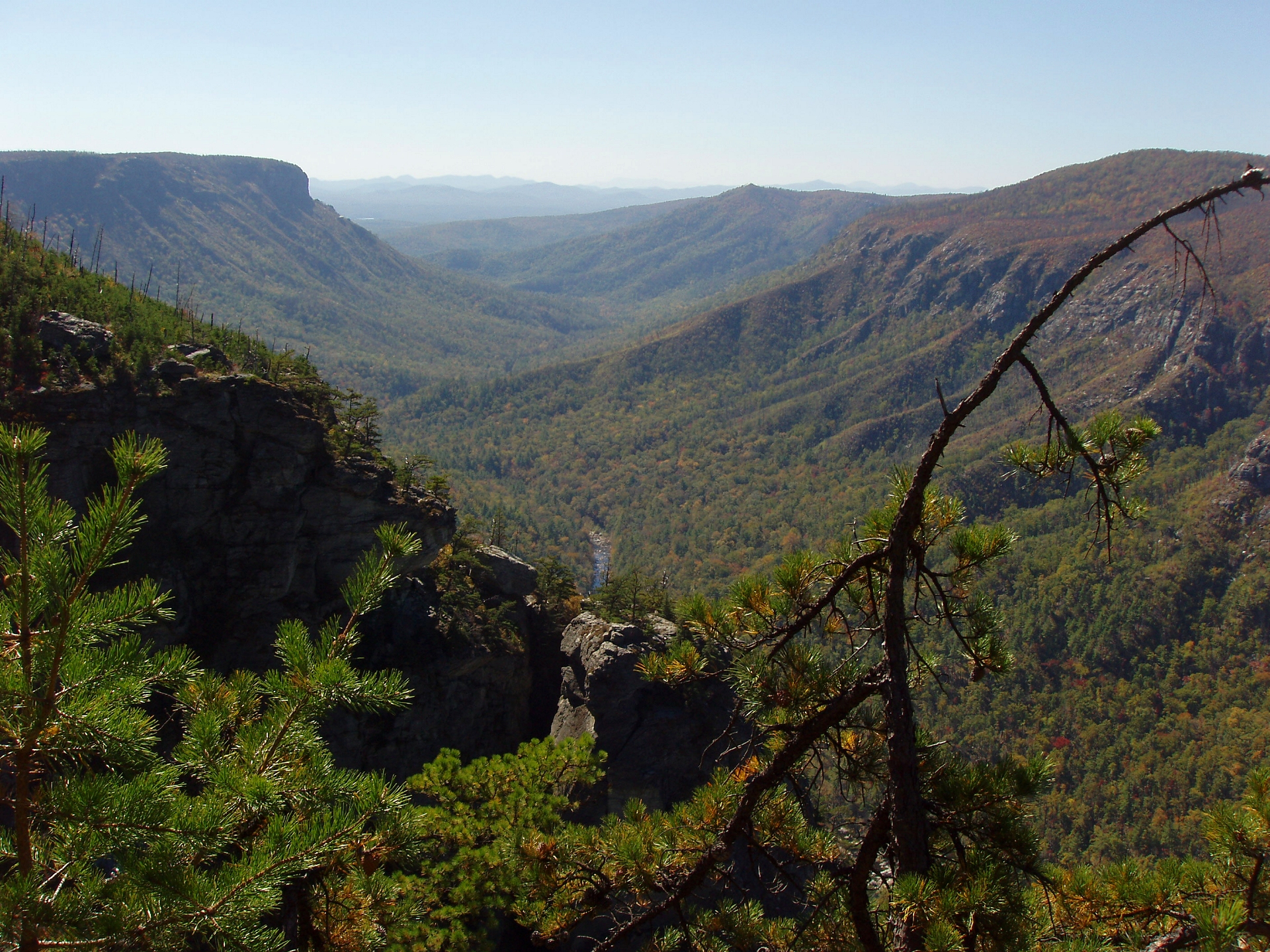
 The recommendation we received was spot on. It was very much worth it to hike down to the NC Wall and Amphitheater. The rock is sheer and there are great views into the gorge, as well as long distance views of the south and north gorge. The photo at the top of this post of Linville River and Shortoff Mountain was take from here. We stopped for lunch at this spot and stayed for probably 45 minutes because it was quite magnificent. Too bad it was so windy. We really had to be careful when we got near cliff edges. The trail down to the Wall and Amphitheater was not real well trodden, so we had a short bit of trouble getting back up the right way, but eventually we made our way back to the Shortoff Trail. We hiked a little bit further south, just to the edge when the trail begins plunging into Chimney Gap, then turned around for our return. When we went back by The Chimneys, those cautious, inexperienced college rope climbers were still doing more talking than climbing.
Best HikeIt took us 5 1/2 hours on this day, but we stopped a lot to take in the scenery, and enjoy the day. Linville Gorge is a fabulous place. I’ve been on hikes from the west rim down into the gorge on the Babel Tower Trail, and to the summits of Hawksbill and Tablerock Mountains, where there are stunning views of the river a couple thousand feet below. If I didn’t live so far away, I am positive I would hike in the gorge a lot more frequently that I do. There are two dozen maintained trails in the Wilderness area, some with very strenuous hiking. Because the area is designated wilderness, there are only trailhead markers, no other signs or blazes inside the wilderness. So topo maps and a compass will be handy. Linville Gorge also is a haven for kayakers and fishing enthusiasts. I rate Linville Gorge Wilderness as a best hike.


For additional tips, information, and useful links, please visit the following: Tips on Linville Gorge

The following are paid links. As an Amazon Associate I earn from qualifying purchases.
 I am Jeff Clark, founder of Internet Brothers, producer of this blog, and passionate about hiking. I live in Western NC near the Blue Ridge and Great Smoky Mountains. Pisgah and Nantahala National Forests are just out my door, so the content will focus on these areas, but let me know what you would like to see on the site.


Copyright © 2011-2023 Internet Brothers. All Rights Reserved. ISSN 2324-6057
Designed by Elegant Themes | Powered by Wordpress | Logo by Design Aspirations
Very interesting! I’ll be at Linville next weekend with a couple of friends. These look like good options for hikes.