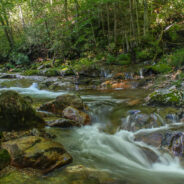
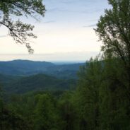
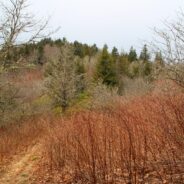
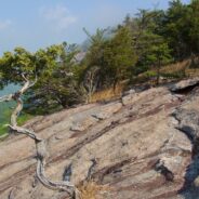
The southeast corner of Shining Rock Wilderness is filled with rivers, creeks and streams tumbling down from the mountains that rise above 6000 feet in the high country. Included among these waterways is the East Fork of the Pigeon River, otherwise known as Big East Fork. A trail follows the river from Hwy 276 to the confluence with Greasy Cove Prong and beyond. This Big East Fork Trail passes several coves and small waterfalls as it climbs nearly a thousand feet through dark and deep forest. The final push is a climb out of the wilderness...
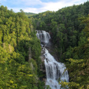
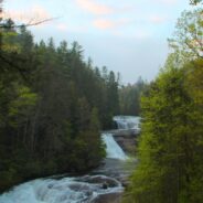
read moreTransylvania County, North Carolina is known as “Land of Waterfalls” for good reason, as there are 250 unique cascades within a short drive of each other. Upper Whitewater Falls on the Whitewater River south of Sapphire is perhaps the most spectacular. There are two distinct overlooks of the 411 foot plunge taken by the river on its path to Lake Jocassee. Nantahala National Forest has developed a small park with family amenities for those who wish to view this spectacular wall of water. Eight short miles north of Upper Whitewater...
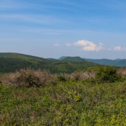
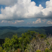
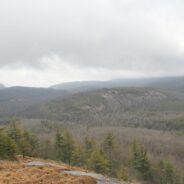
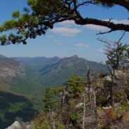
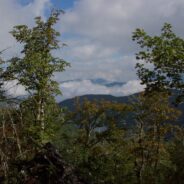
read moreMilepost 420 on the Blue Ridge Parkway is where you will find Black Balsam Road. It’s a short drive to a spruce forest where the Art Loeb Trail crosses the road and heads up onto the balds. This is North Carolina high country. There are several mountains greater than 6000 feet with treeless summits, affording spectacular 360° views of the surrounding Blue Ridge. I love it here. I can’t get enough of the natural beauty to be seen along the Art Loeb Trail as you cross Black Balsam Knob and then Tennent Mountain. The land is rich...
read moreNestled in the woods of Pisgah National Forest in Asheville, the North Carolina Arboretum is a 434 acre public garden located within the Bent Creek Experimental Forest. Set amid rolling hills just off mile 393 of the Blue Ridge Parkway, the Arboretum offers more than ten miles of groomed hiking trails that are suitable for all ages. Home to one of the finest, most unique bonsai collections in the United States, the Arboretum has 65 acres of cultivated gardens that are appropriately seasonal. The Arboretum is an affiliate of the University of...
read moreThis is a two-part hike with a short drive on a forest service road in between. Both the Case Camp Ridge Trail and the North Face Trail start on Forest Road 475B in Pisgah National Forest. The first climbs 1000 feet in 1.7 miles to the Blue Ridge Parkway near Cherry Gap at mile 416. It’s a short walk from the trail to the Cherry Cove Overlook and a close-up view of Looking Glass Rock. Return to the forest road down the same trail and drive another three miles toward Looking Glass. The North Face Trail is a 1.5 mile round trip to the...
read morePilot Mountain stands 5084 feet above the western edge of Pisgah National Forest, near the Blue Ridge Parkway and Looking Glass Rock. There are three ways to get to its summit, but the one I enjoy most is the section of the Art Loeb Trail from Gloucester Gap along Forest Road 475. It isn’t particularly long, but it is quite strenuous. You will get your exercise climbing Pilot Mountain. The views are stunningly panoramic, making it totally worth the exertion. On an especially clear day you can see all the way to Tennessee and South...
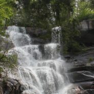
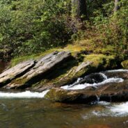
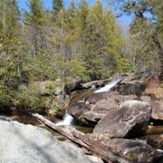
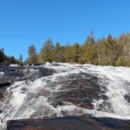
read moreAnother of the myriad of hikes along Forest Road 475 in Pisgah National Forest, this two-parter is near the Fish Hatchery and Pisgah Center for Wildlife Education. First we took a short trip up Forest Road 475B to Slick Rock Falls, then hiked to the base of Looking Glass Rock. The climbers love this area and we encountered some when we reached the base. The main hike was a little further up Forest Road 475 at the Cove Creek Group Camp. The primary feature of this 6-mile loop is Cove Creek Falls, a 50-foot slide waterfall. This is a nice flat...
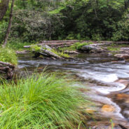
read moreThe Riverside Trail along the South Fork of Mills River in Pisgah National Forest is a great opportunity for boys to be boys, and girls to laugh at them, as the trail fords the river several times. You’ll get to wade in a crisp, cool mountain stream up to your knees as you negotiate the current and the smooth, slippery rocks on the bed. Enjoy the peaceful sounds of the babbling water as you hike alongside this beautiful mountain river that’s full of twists and turns. Start with the two-mile Vineyard Gap Trail up and over Forge...
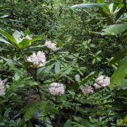
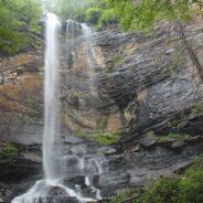
read moreA spectacular waterfall isn’t the only highlight of the Ramsey Cascades Trail in the Greenbrier area of Great Smoky Mountains National Park. The trail to the cascade gains more than 2,000 feet as it follows rushing rivers and streams filled with moss-covered boulders for its four-mile length. The last couple miles pass through old-growth hardwood forest with giant tulip trees, birch and hemlock. Rhododendron is plentiful as you reach the cascade, the tallest waterfall in the park. Water splashes 100 feet over rock outcroppings and...
read moreUsually when you come here you will find a cheerful description of a scenic hike that was fun, and that I recommend for your enjoyment. Instead, I am going to suggest that you stay away from this hike if you value your safety and security. The Brush Creek and Burnett Gap Trails are so terribly maintained as to make them virtually impassible. I’m sure at one time these trails near the French Broad River were quite exhilarating. There are some impressive views of the surrounding mountains from the Brush Creek Ridge. However, this is an...
read moreWith so much interest in The Hunger Games movie, I thought it was time to head out to DuPont State Forest for a dawn hike to Triple Falls, one of the scenes in the film. Triple Falls is a tiered cascade on the Little River that drops 120 dramatic feet and was also featured in the Last of the Mohicans movie. A photo of Triple Falls was used by the Friends of the Falls conservation group to convince the North Carolina Governor and the Council of State to protect the waterfalls of the Little River from private residential development. After...
read moreDesignated a National Wild and Scenic River, the Chattooga River’s headwaters are in North Carolina, but it stretches into Georgia and South Carolina as well. In fact, at one point known as Ellicott Rock, it marks the common tri-boundary of all three states. There are more than 50 miles of trails along the Chattooga River but this four-mile stretch just south of Cashiers, NC is a good introduction to get you in the mood for future exploration. This section of the river is known for the steep, remote Chattooga Cliffs that stand guard...
read moreNorth Mills River Recreation Area in Pisgah National Forest, along with its brother at South Mills River, has a rich trail system. It covers the Pisgah Ridge at the Blue Ridge Parkway down to the North Mills River. A combination of trails leading from the Trace Ridge Trailhead at the recreation area go up, over, and around Coffee Pot Mountain on the way up to the parkway. There are plenty of creeks and streams along the way, as well as views of the surrounding Blue Ridge from the top. This hike occurred on Thursday, March 22, 2012 from 9:00am...
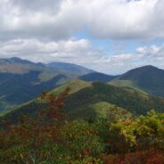
read moreThe Mountains to Sea Trail spans the width of North Carolina, running from the Great Smoky Mountains in the west, to the Outer Banks of Coastal Carolina. Much of the trail in the mountainous part of the state is near or parallels the Blue Ridge Parkway. This section of the MST along the parkway has been designated a National Recreation Trail. With elevations well above 5000 feet, there are segments in Haywood County that make nice day hikes in the high country. One of those is Rough Butt Bald at milepost 427. This hike occurred on Thursday,...
read moreSituated in the far northern reaches of the Panthertown Trail System in Nantahala National Forest, Turkey Knob and Blackrock Mountain offer long distance views of the more well known features of Panthertown Valley. From more than 4000 feet elevation, there are splendid views of Little and Big Green Mountains and The Great Wall. The full expanse of Mac’s Gap lays on the floor of the valley between the cliffs of Blackrock and the Greens. Blackrock Trail also connects with Packs Gap, the western entrance to the trail system. This hike...
read moreTucked away in the northeastern corner of DuPont State Forest in Western North Carolina, Stone Mountain is the highest point in the state forest at 3620 feet. Appropriately named for the exposed granite slab that traverses its summit, Stone Mountain offers a near 360° view of the surrounding terrain to winter hikers. Wintergreen Falls, though not as spectacular as other waterfalls in DuPont, is nonetheless charming as Grassy Creek tumbles through a deep mixed forest. The name was chosen for the evergreen ground cover known as teaberry...
read moreFalls Creek Falls is a double cascade in the northeast corner of the Mountain Bridge Wilderness in upstate South Carolina that free falls more than a hundred feet. In winter there is a distant view of the top of the falls from 800 feet below at the trailhead on Falls Creek Rd. From the falls, Hospital Rock Trail climbs Standingstone Mountain along Falls Creek for ridge top views of the surrounding wilderness area. This very difficult and strenuous trail continues along the ridge and over several streams to the small cave in Hospital Rock,...
read moreTransylvania County, NC is known as the “Land of Waterfalls,” and for good reason. There are more than 250 waterfalls in the county, with many of the most spectacular falls in the heart of DuPont State Forest. Included among those are Bridal Veil and Grassy Creek Falls, both classic slide waterfalls that carve their way over large granite slabs. DuPont also has several pristine lakes such as Lake Julia and Lake Imaging. All of the features of DuPont State Forest are connected by a mature trail system that is well maintained and...
read moreJones Gap State Park sits on the Blue Ridge Escarpment in northwestern South Carolina very near the state line with its neighbor to the north. Along with Caesars Head State Park, these two share an area known as Mountain Bridge Wilderness. The Jones Gap Trail follows the Saluda River along an old interstate road built by Solomon Jones in the 1850s. In this backcountry the river is quite wild with many waterfalls and rapids that add exciting sights and sounds to a dense hardwood and laurel forest. Near the eastern terminus of Jones Gap Trail...
read moreThompson Creek Trail climbs Thompson Ridge from Forest Road 1206 to a point just below the Pisgah Inn on the Blue Ridge Parkway. To the southwest it overlooks the Cradle of Forestry National Historic Site and the Pink Beds. To the east it crosses from Transylvania County into Henderson County and joins the Pilot Rock Trail along the Slate Rock Ridge for the descent across Pilot Rock, and back to the forest road. Along the way is multi-terrain hiking, varying from a creek-side stroll, to switchbacks on all fours, and rocky scrambles across a...
read moreDuPont State Forest, in western North Carolina between Hendersonville and Brevard, was sold to the state by DuPont Corporation under favorable donation and conservation terms in 1996. Within its boundary are more than 10,000 forested acres and 80 miles of hiking and biking trails. Elevation ranges from 2300′ at Hooker Falls on the Little River to 3600′ on Stone Mountain. The state forest lies on an upland plateau of the Little River Valley with moderate hills and mountains that are topped with large granite domes and slabs. Cedar...
read moreMatthews Creek plunges more than 1,000 feet over Raven Cliff Falls into the gorge it has carved below Raven Cliff Mountain. One of a myriad of landmarks along the Blue Ridge Escarpment in Caesars Head State Park, this gorge offers a very challenging yet rewarding hike. Part of the Mountain Bridge Wilderness Area that also includes Jones Gap State Park, this is the most extensive trail system in South Carolina. More like western North Carolina than the coastal and central regions, the South Carolina Upcountry has similar elevation and forest...
read moreDonated to the Carolina Mountain Land Conservancy by Dr. and Mrs. Thomas Florence in 1996, the Florence Nature Preserve is 600 acres on the slopes of Little Pisgah Mountain. With more than five miles of public hiking trails, much of them along a beautiful mountain stream, the preserve contains old growth forest, views of Hickory Nut Gorge, remnants of old cabins, and several small waterfalls. Seasonally there are a variety of rare plants including yellow lady slipper. CMLC conducts regular ecological monitoring of the preserve, implements...
read moreLooking for a hike that includes streams and rivers, hardwood and conifer forests, plentiful rhododendron, and some climbing for good measure? Then the trails along South Mills River that embark from the Turkeypen Trailhead may be just the ticket. Situated in the southeastern corner of Pisgah National Forest, the Mills River Area is the largest in the Pisgah Ranger District, but also perhaps the least well known. Somewhat remote, this area ranges from 2400 feet elevation at the river level to well over 4000 on the mountaintops. The trails are...
read moreChimney Rock State Park is one of the newest in North Carolina. The state acquired the land from private ownership in 2007, and the Carolina Mountain Land Conservancy continues to obtain additional parcels in the Hickory Nut Gorge to eventually expand the state park. The Rumbling Bald section of the park is separate from the more famous namesake, Chimney Rock. Because this park is new and still in the planning stage, trails are primitive, unnamed, and exciting. Maps are limited. The N.C. Division of Parks and Recreation will eventually...
read morePerhaps the most popular hike in the Pisgah Ranger District of Pisgah National Forest, the Looking Glass Rock Trail is a good 3-mile leg stretcher to the top of the famous pluton. Probably not the most scenic hike is the area, but definitely popular because of ease of access, and a little less difficulty than some of the steeper monoliths. Looking Glass Rock is home to peregrine falcons from spring to fall, and excellent multi-pitch and free-climbing year round. Hiking is also four seasonal, just be sure to watch out for slick ice on the...
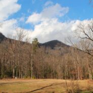
read moreMost of the attention in Linville Gorge is focused on the northern features. There are more trails, higher peaks, and family recreation areas. But the south gorge is every bit as compelling and beautiful, with spectacular panoramic views up the gorge and westward to Pisgah National Forest and the Blue Ridge Mountains. Shortoff Mountain is a thousand feet lower than its more famous brethren to the north — Tablerock and Hawksbill — but it also offers unobstructed views of Lake James to the south. Hiking this trail is a sweet...
read moreMontreat is a small community just north of Black Mountain, NC with a world renowned conference center, a college, and best for us, 20 miles of hiking trails that rival those in nearby Pisgah National Forest for quality and scenery. In particular, the Greybeard Trail is an exceptional workout that climbs more than 2300 feet to the summit of Greybeard Mountain on the Blue Ridge Escarpment where there are stunning views of Mt. Mitchell and its other 6000′ brethren. The trails are contained within private conservation land known as Boggs...
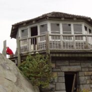
read moreYou don’t have to climb to 6000 feet to get spectacular views of the Smoky Mountains. In fact, Mt. Cammerer has some of the best views in the national park, yet doesn’t even reach 5000 feet. You can see Snowbird Mountain and the Pigeon River Gorge to the east, and Mt. Sterling south, and the full expanse of the national park to the west. Mt. Cammerer was named for Arno B. Cammerer, who was director of the National Park Service from 1933-1940 and was instrumental in the Great Smoky Mountains becoming a national park. The stone and...
read moreKind of an unusual name for the mountain this trail is named after, but it is at 5,200 feet, so the snow comes earlier in the season, and more frequently than in the valleys below. North of Asheville, NC on the Blue Ridge Parkway, this hike is in the Craggy Gardens area. There are splendid views of the Great Craggy Mountains and the Black Mountains from the three summits that are encountered along the trail. You cross Snowball Mountain, Hawkbill Rock, and Little Snowball Mountain along a trail that is roller coaster in nature, lots of up and...
read more I am Jeff Clark, founder of Internet Brothers, producer of this blog, and passionate about hiking. I live in Western NC near the Blue Ridge and Great Smoky Mountains. Pisgah and Nantahala National Forests are just out my door, so the content will focus on these areas, but let me know what you would like to see on the site.


Copyright © 2011-2023 Internet Brothers. All Rights Reserved. ISSN 2324-6057
Designed by Elegant Themes | Powered by Wordpress | Logo by Design Aspirations