The hike on Whitaker Point Trail to Hawksbill Crag is one of the most popular in Arkansas. Aside from the remarkable views of the Buffalo River Gorge, it’s a nice, easy four-season hike that offers wildflowers in spring and summer, and the bright crimson and gold leaves of fall. It takes a little work to get to due to the very remote nature of the location, but once found it is likely to draw you back again and again. I hiked the Whitaker Point Trail on Friday, June 8, 2018 beginning at 8:00AM and finishing about 10:00AM. My plan was to...
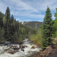
read moreThis trail climbs from East Vail into Eagles Nest Wilderness alongside Gore Creek. There are some short steep sections that wind through meadows and aspen groves which change to spruce-fir stands as the elevation increases. Also look for a wide variety of wildflowers in season. Particularly during spring runoff, Gore Creek rages down the drainage with its series of fast moving cascades. A short hike along the creek can provide pleasant picnic spots or great fishing opportunities. My brother Dave and I hiked the lower Gore Creek Trail on...
read moreNamed for Butch Cassidy, the late-19th century western outlaw who hung out in these parts, Cassidy Arch stands on a precipice overlooking the Grand Wash in Capitol Reef. Cassidy Arch Trail climbs 670 feet from the wash to a slickrock bench high above the canyon. Iconic landmarks like Capitol Dome are visible along the trail that hangs on the canyon ledge. Better wear your sturdiest boots for this hike. The terrain is rocky and rugged and just waiting for you to take a misstep. My brother Dave and I hiked the Cassidy Arch Trail on Monday, June...
read moreThe mornings were spent hiking at Bryce Canyon, but the afternoons and evenings we played tourist just like thousands of others. We rode the shuttle. We checked out all the overlooks. We oohed and aahed. We took lots of pictures. The first three miles inside the park is where you will find Bryce Amphitheater. The most iconic — but also most popular — views are found along the canyon rim here. Bryce Point, Inspiration Point, Sunrise and Sunset Points all have breathtaking viewing of the hoodoos that populate the amphitheater. We...
read moreYou can’t really tell from the overlook, but there’s a lot to like down in Swamp Canyon. For one, this is part of Bryce Canyon Wilderness, so it is definitely less crowded than the majority of the national park. There are great views of Wightman Bench and Swamp Canyon Butte from down in the canyon. Wildflowers and wildlife are abundant during the green seasons. For a quiet adventure off the beaten path, give Swamp Canyon a try. My brother Dave and I hiked the Swamp Canyon Trail on Sunday, June 3, 2018 beginning at 1:00PM and...
read moreBristlecone Loop, accessible from Rainbow Point at the southern-most end of Bryce Canyon National Park, meanders through a spruce-fir forest atop the highest portion of the park, reaching elevations over 9,100 feet. This short and easy stroll passes by bristlecone pines up to 1,800-years-old and experiences vistas reaching into Dixie National Forest and Grand Staircase-Escalante National Monument. While still popular, this far end of the park is not nearly as crowded as the primary amphitheater area, but no less beautiful. My brother Dave and...
read moreGolden hour is special for any place with picturesque scenic beauty, especially if you also happen to like photography. There aren’t many places more stunning during the golden hour — that time right after sunrise and right before sunset — than Bryce Canyon. There are even viewpoints named for these wonderful times… Sunrise Point and Sunset Point. So how about a trail that goes from one to the other while also diving down amidst the wondrous hoodoos and pine forest that give Bryce Canyon its majesty and character? That...
read moreArriving at Bryce Canyon mid-afternoon, Dave and I headed for the short Mossy Cave Trail to get our feet wet among the majestic hoodoos. This trail actually begins outside the park at the far northern reaches, then enters the park boundary on foot. The trail is a streamside walk up to a mossy overhang and small waterfall. Mossy Cave isn’t a cavern, but is a grotto, created by an underground spring. We hiked to Mossy Cave on Saturday, June 2, 2018 beginning at 3:00PM and finishing about 4:00PM. Our plan was to explore this northern...
read moreWhat better way to spend May Day than wildflower hunting on Pisgah National Forest? We always think of the national park in the Smokies as being the go-to destination for Spring wildflowers in Western North Carolina. However, Pisgah National Forest is right up there. As you will see from the gallery below, there is quite the wide variety. I picked two destinations in the Pisgah Ranger District: Daniel Ridge Trail following the Daniel Ridge Creek, and the Andy Cove Nature Trail at the district Visitor Center. I was not disappointed at either...
read moreWhat to do if you’ve got half a day to kill on the Tennessee side of the Smokies? Well, if it’s April, the obvious conclusion is a wildflower hunt along Little River Road between Sugarlands and the Townsend-Y. On Saturday, April 21st, I had an invitation to the annual Great Smoky Mountains National Park Volunteers Appreciation Banquet, but it wasn’t to begin until 6:00 PM. So I planned to arrive in the morning and spend the day exploring various of the dozens of quiet nature trails looking for Spring wildflowers, and...
read moreThis is one of my new favorite Spring wildflower hikes in the Smokies. The flowers are brilliant along both the Bradley Fork and Cabin Flats Trails. The Smokemont region of the Smokies is one of the most convenient, located just a short few miles northwest of the Oconaluftee Visitor Center off Hwy 441. It is four miles up Bradley Fork to Cabin Flats Trail, then another 1.1 miles to campground 49 at Cabin Flats. All the while the sounds of the stream will be your constant companion. I hiked this section of the national park on Friday, April 6,...
read moreThis park sits right on the cliff’s edge of the Blue Ridge Escarpment that drops down from the mountains in western North Carolina to the upcountry of South Carolina. The park is more than 3,000 acres of trails, lakes, cabins and camping. Pinnacle Mountain Trail is the most challenging within the park, with a climb that exceeds 2,300 feet. The lower section follows Carrick Creek, while the upper levels offer fantastic views into the South Carolina Upstate, with massive rock outcroppings along the way. Ken and I hiked Pinnacle Mountain at...
read moreThere was a major snowstorm over the Great Smoky Mountains on December 8-9, 2017, particularly on the Western North Carolina side. Seeing Roan Highlands covered in a blanket of snow has always been a goal of mine ever since the first time I walked the Appalachian Trail across Round, Jane, and Grassy Ridge balds. With that in mind, I set out for the Highlands on the morning of December 10th. I was not disappointed. To be honest, it couldn’t have worked out better. The road crews had done a fabulous job of clearing all the back country...
read moreAnother of the fun and exciting South Carolina state parks that line the Cherokee Foothills Scenic Highway, Keowee Toxaway offers two hiking trails that take visitors over a natural bridge and through the foothills of the Blue Ridge Mountains, land once traveled by Cherokee Indians. Much of the trail follows the shore of Lake Keowee through the healthy oak/hickory forest that surrounds it. The trail’s namesakes are interesting features, but the highlights of this hike are the terrain and the views. I hiked Natural Bridge and Raven Rock...
read moreCongaree National Park, located in the heart of South Carolina, is a land of towering trees, of floods and fire, of woodland paths and water trails used by people for more than 10,000 years. This rare, old growth forest became a national park in 1976. These ancient trees have witnessed wars, slavery, freedom, and destruction. There are 25 miles of hiking trails in Congaree, including Oakridge. Passing through a rich stretch of old growth forest, along the way you will cross a number of sloughs, or small creeks that carry floodwaters into and...
read moreOne of the more enjoyable trails I have hiked recently in the Smokies, Old Sugarlands follows West Prong of Little Pigeon River for a mile and a half, then turns to the east and ascends the western flank of the LeConte Ridge another 2.4 miles to a pastoral setting known as Cherokee Orchard. This trail receives surprisingly little use despite being surrounded by a hub of activity at Sugarlands Visitor Center and Park Headquarters. Once you reach the top, you can extend the hike 1.8 miles round trip with a visit to historic Bud Ogle Cabin, or...
read moreThere is no denying 2017 has been a disappointing year for fall foliage in the Smokies — so far. That’s why I titled this essay In Search of… you really have to look hard to find much beyond a few patches of yellow. The oranges and reds have been nonexistent. I started the day before dawn from Cades Cove driving toward Gatlinburg on Little River Road, where I turned onto Newfound Gap Road for a climb up into the Tennessee Smokies. First stop was Maloney Point where the sun was casting light above the ridges, but had not yet...
read moreThis was the first trail I hiked in Great Smoky Mountains National Park. It was back in 2008 or so, well before I started this website. So I thought it must be time, nearly 10 years later, to do it again and tell you about it. Rich Mountain Loop is a combination of three trails: Rich Mountain Loop Trail, Indian Grave Gap Trail, and Crooked Arm Ridge Trail. Most people hike the loop clockwise, but the direction really doesn’t matter. It is no more difficult, or easy, whichever you choose. After circling the northeastern edge of Cades...
read moreThe air is nearly always cool at Caesars Head State Park in upstate South Carolina. It sits right on the edge of the Blue Ridge escarpment where refreshing breezes from the piedmont waft up and over the massive walls of rock. This hike is a casual stroll through hardwood forest on a sand and clay pathway to the Matthews Creek gorge and a suspension bridge over the precipice of Raven Cliff Falls. Expect something different, and enjoyable, in each season. I hiked this route to Matthews Creek on Monday, August 28, 2017 beginning at 9:45AM and...
read moreThis trail follows the McCullough Creek drainage up the gulch beneath the massive summit of 14,225′ Quandary Peak. It starts on an old mining road south of Breckenridge, CO, then changes to single track trail as it climbs the gulch. You’ll pass through pine and fir forest, get splashed by White Falls, marvel at the colorful granite, and count the variety of summer wildflowers along the way. Watch too for mountain goats among the talus, a common sighting. Picturesque Upper Blue Reservoir sits at the top of the drainage offering a...
read moreThe easier of the trails at Loveland Pass, West Ridge surrounds two sides of the bowl that makes up the Loveland area and the I-70 corridor over the Continental Divide. Still, at 11,990 feet, this is no piece of cake for folks like me who are used to mountains no more than half the elevation. Several ski slopes are visible from the ridge. Look too for cute rodents to peek out of their ground holes, like pica, chipmunks and marmots. My brother Dave and I hiked the short West Ridge Trail on Saturday, July 15, 2017 beginning at 7:30AM and ending...
read moreThis marvelous example of Rocky Mountain vistas starts, oddly enough, directly beside Interstate-70 at Colorado’s 10,585′ Vail Pass. The trail winds through forest and meadow, then climbs steeply above treeline to Uneva Ridge, 1,500 feet above. Along the way you will enjoy breathtaking views of four distinct mountain ranges as you pass into Eagles Nest Wilderness, and experience the high mountain air. If you still have some energy left, you can continue to either Uneva Pass, or Uneva Peak, another solid 500 feet higher. Regardless...
read moreHighway 4, west out of Leadville, CO offers a driving adventure that takes you past lakes, among a various assortment of summer wildflowers, and over a high mountain pass that tops out just short of 12,000 feet. I needed the drive rather than hiking the first day after recovering from a newly discovered adult-onset allergy to cashew nuts. The annual visit with my brother Dave started with an overnight emergency room experience. The good folks at Vail Valley Medical got me back on my feet though, and by the next day I was ready to go...
read moreI like to do most of my summertime hiking in the high country to avoid the heat, and the bugs. It’s like getting extra, added months of spring. So when the first week of summer rolled around, I thought of that section of Pisgah National Forest that lies between Shining Rock and Middle Prong Wildernesses, surrounded by the Blue Ridge Parkway, Hwy 215, and Black Balsam Road. You can make a very nice 9-mile loop out of the Flat Laurel Creek Trail and the Mountains to Sea Trail, staying between 5,000-6,000 feet elevation the whole way....
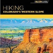
read moreColorado’s Western Slope is rich in backcountry hikes. Knowing where to find them — and what to expect on a trail — just got easier with a new guidebook by Grand Junction outdoor writer Bill Haggerty. The Falcon Guides “Hiking Colorado’s Western Slope” has details on more than 45 trails in Western Colorado. It doesn’t have just the standard route descriptions. Haggerty includes historical tidbits, geological information, suitability for canines, and observations gleaned from a lifetime of hiking in...
read moreHo. Hum. Just another day at Roan Highlands. Now, obviously I’m being facetious. Roan Highlands is probably my favorite place to go in all of Western North Carolina, especially in mid-June when it is catawba rhododendron and flame azalea time. It’s exciting to hike on the iconic Appalachian Trail, the views of Tennessee and North Carolina on either side of the ridge are among the best you will find anywhere, and the flowers are, to put it mildly, simply gorgeous. This visit was on June 15, 2017. I arrived at 6:45AM with bad...
read moreRemote. This little slice of Nantahala National Forest is truly far from anything. Once you are a mile into the woods from the trailhead, there is next to no evidence of human activity. It’s hard to know how many folks come here to hike, but there aren’t many boot prints in the mud. There are, however, plenty of deer tracks… and wildflowers. Wow, are there wildflowers. From Sugar Creek Gap there are great views of the Blue Ridge to both the north and the south, then the hiking is through a dense forest comprised of mostly...
read moreBaxter Creek Trail has a well-earned reputation as one of the hardest hikes in all of Great Smoky Mountains National Park. Starting at the Big Creek picnic area near Waterville, NC it climbs more than 4,000 feet over 6.2 miles, roughly 700 feet/mile. That will get your attention. Look for stunning forest scenes, waterways that keep the forest green, seasonal wildflowers, and sweeping vistas from the summit of 5,842′ Mt. Sterling. Take plenty of food and water, and energy, because you will definitely need it. But also take your time and...
read moreWhen looking for some WNC high country scenery and perhaps refreshing cool air on a warm day, one of the first destinations I think of is the Black Balsam area at milepost 420 on the Blue Ridge Parkway. There are half a dozen mountains here that stand above 6,000 feet, with encompassing 360° views from their treeless summits. This land that lies between the Shining Rock and Middle Prong Wildernesses is pierced by the Art Loeb Trail, a favorite of anyone who visits the Pisgah Ranger District. My hiking pal Ken and I have walked this region...
read morePerhaps the finest creek side trail in all of Great Smoky Mountains National Park, Middle Prong Trail actually follows Lynn Camp Prong. Lynn Camp and Thunderhead Prong join to form Middle Prong just below the trailhead. You will walk alongside Lynn Camp Prong for the entire length of this hike, passing dozens of swift cascades and two exciting waterfalls. Look for a wide variety of wildflowers in spring and a splendid leaf peeping show in autumn. I visited Tremont on Wednesday, May 10, 2017 beginning at 7:30AM and ending about 10:00AM. My...
read more I am Jeff Clark, founder of Internet Brothers, producer of this blog, and passionate about hiking. I live in Western NC near the Blue Ridge and Great Smoky Mountains. Pisgah and Nantahala National Forests are just out my door, so the content will focus on these areas, but let me know what you would like to see on the site.


Copyright © 2011-2023 Internet Brothers. All Rights Reserved. ISSN 2324-6057
Designed by Elegant Themes | Powered by Wordpress | Logo by Design Aspirations