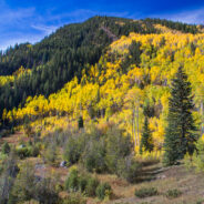
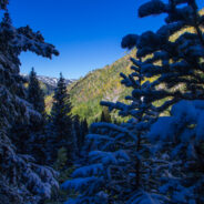
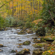
I went to the Colorado Rockies in late September-early October with the expressed intention of being there for the autumnal yellowing of the aspen trees. It’s a gorgeous sight, the leaves take on a golden glow that shimmers in the breeze. Well, mission accomplished. My brother saved East Lake Creek Trail for the last hike of my visit, one that walks for miles in and among both young and mature aspen forest. Most of the younger trees were revealing their peak shining moment, and the larger, older trees displayed that in-between green and...
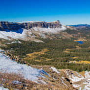
read moreAcrophobia? Then you may want to stay home for this one, or at least don’t go all the way. That was my choice when my life-long fear of heights (that I thought I had conquered) kicked in. Devils Causeway, the destination for this hike on East Fork Trail in Flat Tops Wilderness, is an extremely narrow backbone atop a rocky ridge named the Chinese Wall that drops precipitously 800 feet on each side. That would be your first bounce, then you would roll another 700 feet before coming to a rest. The good news is the trail to get there is...
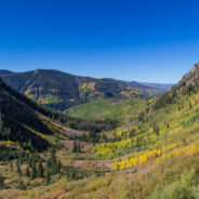
read moreBeginning on Columbine Dr. in East Vail, CO, the Bighorn Trail climbs steeply out of the Vail Valley, then more gradually climbs up through stands of aspen and pine. The trail passes beaver ponds and the remains of old mining camps as well as Bighorn Creek. Near the halfway point, be sure to turn around because the views of Vail and Bighorn drainage behind you are exceptional. You will reach Bighorn Falls and your first glimpse at Grand Traverse Peak in the Gore Range, then make another steep climb through willows and a boulder field. The...
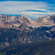
read moreBowman’s Shortcut is an easy-to-get-to trail that tops a ridge that enables views of three different mountain ranges — Sawatch, Gore, and Tenmile. You’ll start out climbing through a pine forest with occasional glimpses of the distant peaks through the trees, then reach the bald ridge and the magnificent views of some of Colorado’s highest mountains. Cross country skiers use this trail to reach Commando Run, and summer hikers can connect to the Two Elk National Recreation Trail. For us, it made for a delightful access...
read moreBooth Lake Trail begins at Booth Falls Road in East Vail, CO and ends at Booth Lake. The trail climbs up the Booth Creek valley through mostly aspen groves before passing the 60-foot Booth Falls. Beyond the falls the trail winds through conifer forests and meadows filled with wildflowers. Above 10,000 feet the trees thin and the terrain changes offering views of the Gore Range. The last 1/4 mile to Booth Lake is steep and rocky. This hike occurred on Saturday, September 28, 2013 from 8:00am to about 9:30am. Our plan was to see what the...
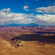
read moreCanyonlands preserves a wilderness of rock at the heart of the Colorado Plateau in Southeastern Utah. Water and gravity, this land’s prime architects, cut flat layers of sedimentary rock into hundreds of canyons, mesas, buttes, fins, arches, and spires. At center stage are two canyons carved by the Green and Colorado rivers. Island in the Sky stands more than two thousand feet above both rivers, north of their confluence, with breathtaking views that stretch to the horizon 100 miles away. There are many trails on Island in the Sky. This...
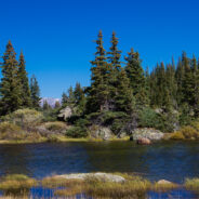
read moreOne of the things I miss about the Blue Ridge and Smokies is mountain lakes. The Rocky Mountains are adorned with memorable alpine lakes, usually surrounded by majestic peaks and bountiful evergreen forest. All you need is an input and output source, like Fall Creek in the case of Lake Constantine, and a bowl between mountains to collect the water. Fall Creek Trail climbs 1,700 feet through spruce and pine forest to Lake Constantine at 11,370 feet. Fall Creek spills into the alpine lake not far below its headwaters. Include fabulous views of...
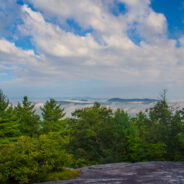
read moreNestled in the beautiful Blue Ridge mountains near Asheville, North Carolina, YMCA Blue Ridge Assembly is a full-service conference center situated on 1,200 acres of woodland beautified by mountain streams, wildflowers, ridges, valleys and spectacular views. What is little known about the property is the extensive hiking trail system. Primary among these is the High Windy Trail, a 1,600 foot climb to scenic views of Black Mountain, Montreat, Greybeard, and Mt. Mitchell. While you’re there, enjoy the rich history of the YMCA Assembly,...
read moreCarl Sandburg’s wife Lilian discovered the mountain farm named Connemara in the community of Flat Rock, south of Asheville, NC. From 1945, until his death in 1967, the famous American poet, biographer, and Pulitzer Prize-winning author lived and worked on the 264-acre estate. The family then sold the property and donated the contents to the National Park Service and Connemara became the first National Historic Park honoring an author. There is a 5-mile trail system on the estate that is very popular with locals looking for a quiet and...
read moreMost people who head out Clingmans Dome Road in Great Smoky Mountains National Park are there to climb the half mile to the summit of the 2nd highest mountain in the East. But here at Meanderthals, we aren’t most people. Below Clingmans Dome are trails that explore the ridges and drainage on the south face. Included among those are Forney Creek Cascade, a classic slide waterfall three miles down the Forney Creek drainage, and Andrews Bald, at 5,920′, the highest bald in the national park. Either one would stand alone as a...
read moreGraveyard Fields is an anomaly — a high mountain meadow and bog surrounded by 6,000 foot mountain peaks. The wide-open spaces found at Graveyard Fields are a rarity, an exception in the otherwise lush and densely forested slopes of Pisgah National Forest and Shining Rock Wilderness. Popular with locals and tourists alike, no trip to the high country of Western North Carolina on the Blue Ridge Parkway is complete without it. Two waterfalls with the simple names of Upper Falls and Lower Falls, and with relatively easy access, delimit the...
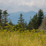
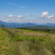
read moreNortheast of Mars Hill, NC, the Big Bald Range straddles the Tennesssee/North Carolina border and marks the boundary between Pisgah and Cherokee National Forests. The Appalachian Trail (AT) follows the state line, as it does for nearly all its length between these two states. The destination for this hike is 5,516 foot Big Bald Mountain, another of the grassy balds that are common in this area. You can make your day as long or as short as you like by exploring the AT in either direction. At least be sure to also check out Big Stamp, another...
read morePeaceful. If I were to think of a single word to describe the Pink Beds Loop Trail, that would be it. Peaceful. Located in a high valley in the Cradle of Forestry, Pink Beds is surrounded by the tall mountains and lush woodlands of Pisgah National Forest. Home to rare mountain bogs, unique vegetation, and unusual wildlife, this area is ideal for those who like to explore Nature. The south side of the loop trail follows the headwaters of South Mills River, often on a boardwalk that enables you to peer into the water of the marshy bogs. This is...
read moreHigh above the community of Erwin, Tennessee, the Appalachian Trail follows the North Carolina / Tennessee state line through the Unaka Range. From a grassy bald ridge with the appropriate name Beauty Spot, to the summit of 5,184′ Unaka Mountain, the trail winds northeasterly for a 4-mile section through a continuously changing ecology. Stand on the bald with spectacular views of the Big Bald Mountains and the towns below, then follow the trail through woods filled with ferns to Deep Gap, another meadowy mountain bald, then onward for a...
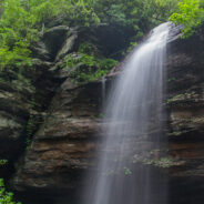
read moreThis short hike is family friendly, including even toddlers. The Moore Cove Trail leads you 0.7 mile to Moore Cove Falls, a 50-foot free-fall over a cave-like outcropping. As long as you’re careful, you can get in behind this waterfall and peer at the forest through the cascade. Hey, on a hot day it makes a great refreshing shower. In season, you may discover a variety of wildflowers along the trail including orchids, lady slippers, jack-in-the-pulpit, dwarf iris, and of course, the ubiquitous rhododendron. This hike occurred on Sunday,...
read moreLooking to do some ridge hiking down, down, down from the Blue Ridge Parkway into Pisgah National Forest? Overlooking North Mills River, the Little Pisgah Ridge starts at 4,800′, then drops down into the Big Creek drainage some 2,100 feet below. Catch your views of the mountains on the Parkway before you start because this is a heavily forested hike that instead offers a myriad of wildflower sights and scents. Enjoy the creek at the bottom, then it’s a long, hard climb back up the ridge to complete the round trip. This hike...
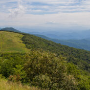
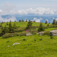
read moreLocated along the North Carolina/Tennessee state line, and where Pisgah and Cherokee National Forests merge, Grassy Ridge in the Roan Highlands is the longest stretch of grassy balds in the Appalachian Mountains. The Appalachian Trail navigates this stunning ridge, hopping from Carvers Gap to Round Bald to Jane Bald, and on to the 6,169 foot Grassy Ridge Bald. The Highlands are a haven for wildlife, and mountain bushes like rhododendron, flame azalea, and green alder. Rare flowers are found here as well, including species such as spreading...
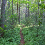
read moreSometimes even the most benign little trail can be filled with wondrous surprises. Nestled in a small valley between Bryson and Caney Mountains in North Mills River, North Carolina, and surrounded by Pisgah National Forest, the Foster Creek conservation easement and trail is just such a place. Barely a mile in length, and nearly flat, this four-season trail is ideal for novice hikers or parents with young children. With a soft, cushioned pine straw bed, and lined with wildflowers, ferns, and fungus, you might even consider trying Foster Creek...
read moreStanding guard along the state line, Max Patch Mountain is a grassy bald with fabulous panoramic views of the surrounding North Carolina and Tennessee Great Smoky Mountains. Oh, and by the way, the celebrated Appalachian Trail crosses its 4,629 foot summit. So far as Southern Appalachian summits go, this one is moderately short and easy, but you can make a day of it by taking in one or more of the other trails found in the vicinity, including Buckeye Ridge. Another grassy bald itself, Buckeye Ridge sits off the southeastern shoulder of Max...
read moreThe Appalachian Trail straddles the Tennessee/North Carolina state line in Great Smoky Mountains National Park for more than 70 miles. A particularly scenic day hike on the AT is the four mile stretch from Newfound Gap to Charlies Bunion, a remote and rugged outcropping that sits on the ridge between the states. Along this sharp ridge you will pass magnificent views of the Carolina Smokies to the southeast, and the massive shoulders of Tennessee’s Mt. LeConte northwest. Much of the way offers long distance viewing on both sides of the...
read moreHiking a state line offers interesting boundary markers and competing blaze markings. This hike on the Foothills Trail follows the boundary from the highest point in South Carolina — Sassafras Mountain — to a convenient end point at Gum Gap in North Carolina. Because of the length, for us this was a two vehicle hike, with one left at each end. Expect a roller coaster trek as you move from mountaintops to gaps on the edge of the Blue Ridge Escarpment. Along this forested hike, you will experience outstanding vistas of the South...
read moreBack to Rough Butt Bald Overlook on the Blue Ridge Parkway, and another visit to the Mountains to Sea Trail. The MST follows, or remains close to the Parkway through much of Western North Carolina, so there are a number of easily accessible jumping off points that head into the backcountry. Middle Prong Wilderness was designated in 1984 and spans rugged high-elevation ridges with old growth forest and grassy balds like Fork Ridge. This is a short out-and-back hike in the high country that explores murky, mossy evergreen forest on its way to...
read moreSoutheast of the Cradle of Forestry National Historical Site is a remote area of Pisgah National Forest with trails that will take you along ridge lines with views of the Blue Ridge Parkway and Looking Glass Rock, then follow creeks and streams as they tumble down the mountains to the western end of South Mills River. You will encounter names like Squirrel Gap, Glady Branch, and Otter Hole as you traverse this long, but not particularly difficult loop. There’s something for everyone with long distance vistas, beautiful forest, and...
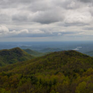
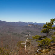
read moreCedar Rock is one of several granite pluton monoliths found in the Davidson River area of Pisgah National Forest. More difficult to get to than its nearby brethren, Looking Glass and John Rock, Cedar Rock has outstanding long distance views from both the east and west sides of its summit. You will have to work to get there, climbing nearly 1,700 feet from the valley floor at the Pisgah Center for Wildlife Education, but the end result is well worth the effort. You’ll see two states and four counties, 6000′ mountain peaks, stunning...
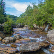
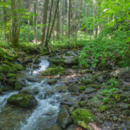
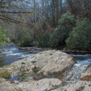
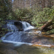
read moreThere is a series of waterfalls not far from the Pisgah Center for Wildlife Education and State Fish Hatchery on Forest Road 475. Collectively known as Cedar Rock Falls, they carry Cedar Rock Creek on its plunge down the mountain to Davidson River. Access to these falls and the wetlands beyond is via the Cat Gap Trail, a jumping off connector trail for many of the landmark features found in Pisgah Ranger District. One connection is with Butter Gap trail as it follows Grogan Creek through Picklesimer Fields and on to Long Branch. This hike...
read moreThe Rough Creek Watershed is 870 acres of protected mountain land north of Canton, North Carolina, in Haywood County. This is privately held land, so there are rules for hikers and mountain bikers, but it is open to the general public. The trail system is more than 10 miles, and incorporates historical road beds with well maintained single tracks for foot and bike activity. The watershed contains nearly seven miles of streams, seeps, springs, and bogs. We saw lots of evidence of wild turkeys, while black bear and bobcat are also known to...
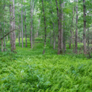
read morePerhaps you’re looking for a short hike that will really stretch your legs and get your heart pounding. Then you may want to consider the Pressley Cove/Maxwell Cove loop that is not too far from the Pisgah Ranger District headquarters. You’ll climb more than 1,400 feet in just a little over a mile through a beautiful poplar, oak and beech one-age forest. Follow Pressley Creek on the way up, and Maxwell Creek on the way back down, with a stretch on the ridge at the top that offers views of the Blue Ridge Parkway far in the...
read moreOne of many trails found off Forest Road 475 in the Pisgah Ranger District near the State Fish Hatchery, Daniel Ridge Loop is a beautiful 5-miler that takes you near the headwaters of Davidson River. As you climb the ridge you’ll have views of the Looking Glass and Cedar Rock plutons on the south side, and drainage off four ridges into Davidson River on the north side. Long-distance viewing is best in winter, but the forest comes alive with dogwood, silverbell, blueberry and rhododendron in the green months. An occasional spruce joins a...
read moreNorth Mills River Recreation Area in Pisgah National Forest, along with its brother at South Mills River, has a rich and varied trail system. Among them, Fletcher Creek is a typical streamside trail that passes an old beaver pond, thick forest of hardwood and hemlock, several grassy meadows and a number of log bridge crossings over Fletcher Creek, Spencer Branch and Middle Fork. This isn’t particularly difficult hiking, but it is deceptively long. Keep your eyes and ears out for mountain bikers as this is a very popular track for them...
read more I am Jeff Clark, founder of Internet Brothers, producer of this blog, and passionate about hiking. I live in Western NC near the Blue Ridge and Great Smoky Mountains. Pisgah and Nantahala National Forests are just out my door, so the content will focus on these areas, but let me know what you would like to see on the site.


Copyright © 2011-2023 Internet Brothers. All Rights Reserved. ISSN 2324-6057
Designed by Elegant Themes | Powered by Wordpress | Logo by Design Aspirations