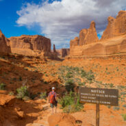
Within Arches National Park you will discover a landscape of contrasting colors, landforms and textures unlike any other in the world. The park has over 2,000 natural stone arches, in addition to hundreds of soaring pinnacles, massive fins and giant balanced rocks. This red rock wonderland will amaze you with its formations, refresh you with its trails, and inspire you with its colorful sunsets. From Courthouse Towers parking area, the trail ascends gradually, meandering along Park Avenue Wash into a spectacular canyon, and continues up the...
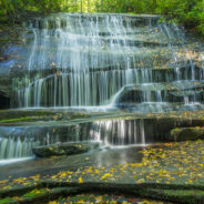
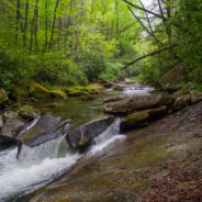
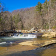
read moreLooking for an easy hike of less than five miles that will take you to several different waterfalls? Yes? Then this just might be the one for you. It starts on the ever popular Cat Gap Trail, passes two falls on Cedar Rock Creek and a whitewater cascade on John Branch before hopping on the Butter Gap Trail to follow Grogan Creek through Picklesimer Fields to the truly picturesque Grogan Creek Falls. All of that in only 2¼ miles one way. This is easy hiking too, climbing less than 500 feet over the full course. What are you waiting for?...
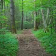
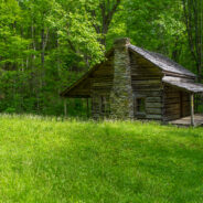
read moreStart your morning with the elk rut in Cataloochee Valley. Then gear up for this enchanting deep forest hike that includes mountain creek crossings, giant old growth tulip poplar and hemlock, occasional views of the Smoky Mountains surrounding the valley, and a stroll down memory lane at historic settler homesteads. Enjoy this 10-mile loop in three segments, on three different trails, as you also discover means of accessing other sections of the national park. This is probably my favorite Cataloochee hike as it combines wildlife, good...
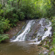
read moreThe Deep Creek area in the Smokies, just north of Bryson City, NC, is a water wonderland. Creeks and branches descend through every nook down the surrounding mountains. The documentarian Ken Burns describes Deep Creek as one of his favorite places to visit in the national park. Three picturesque waterfalls are in close proximity to the campground, and hiking trails abound. The area is also home to Lakeview Drive, aka the infamous “Road to Nowhere,” and the numerous trails that start there. You can circle Fontana Lake, or follow...
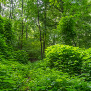
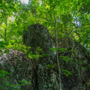
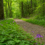
read moreLocated in an area of Polk County, NC between Tryon and Saluda, the Norman Wilder Forest is a conservation easement that first opened to the public in 2001. Owned and operated by the Pacolet Area Conservancy, the 185 acres of protected mature third growth mixed hardwood forest provide hikers with a small trail system that meanders beneath the shady canopy. Lying on the southern slope of Little Warrior Mountain, you will find trails to sheer granite walls, weeping waterfalls, rocky outcroppings, and vistas of the surrounding farmland. Despite...
read moreWater. Forest. Mountains. History. For me, that is what Great Smoky Mountains National Park is all about. On the Smokemont Loop hike you will get all of them. For the first couple miles, stroll along one of those beautiful mountain streams the Smokies are known for, then prepare your legs and lungs for a tough climb 1,350 feet through the forest to the top of the ridge. In seasons when the leaves are down you’ll be able to view Newfound Gap far to the north. As you descend back to the campground you will pass an old homestead and...
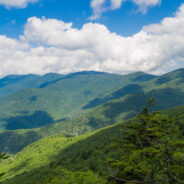
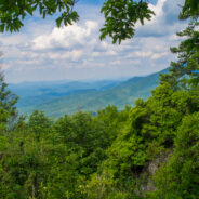
read moreAnother foray into the Black Mountains led us to summits with names like Point Misery, Little Butt and Big Butt. The Big Butt Trail takes off from Balsam Gap on the Blue Ridge Parkway along Brush Fence Ridge, roller-coastering across several peaks and gaps. The forest is filled with floral and fungal oddities, and old-growth spruce and pine that protect the ridge like gentle giants. The razor ridge offers occasional panoramic views of the Black Mountains Range, including Mt. Mitchell State Park, and the vast expanse of Big Tom Preserve down...
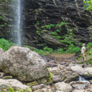
read moreSometimes you have to work for the reward at the end of the trail. Hiking from Craggy Gardens to Douglas Falls is a prime example. You will descend 1,350 feet from the Blue Ridge Parkway to this 70-foot waterfall through a luscious forest of birch, maple, and beech, even enjoying old growth hemlock along the way. Expect a rough hike, as the terrain is very rugged in the Great Craggy Mountains. Hop rocks crossing various branches of Waterfall Creek that also have smaller attractive waterfalls of their own. What goes down, though, must come...
read moreHiking among the giants of the East. That’s what you’re doing when you take the Blue Ridge Parkway to Mt. Mitchell State Park for this trek on the Mountains to Sea Trail in the Black Mountains. With fabulous views of the Blacks and the Great Craggy Range, and closeup experiences with gnarly old growth fir and spruce krummholz, this stretch of the MtS is some of the best of the North Carolina high country. The trail climbs through ancient forest, past moss-covered granite outcrops, to the crest of the ridge and Blackstock Knob...
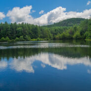
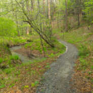
read moreThere are 84 named trails in DuPont State Forest. This robust and mature trail system is a series of arteries that connect the various and disparate sections of this family friendly recreation area. In the central region of the state forest I put together a semi-loop hike that took me first to a waterfall, then to a hilltop summit, and finally to the tranquil banks of a mountain lake. Along the way I was able to enjoy the thoroughly entrancing forest and its wide variety of wildflowers and fungus. I took this hike on Friday, July 25, 2014...
read moreI always enjoy hikes along the South Mills River in the Pisgah Ranger District. This loop follows the north side of the riverbank for several miles along an old logging road. But to get there, first you cross Sharpy Mountain from Turkeypen Gap. The trail travels through beautiful hardwood and heath forest as it roller-coasters across four gaps to its meeting with Wagon Road Gap Trail. It’s then a steep downhill to South Mills River and a lovely stroll next to the scenic mountain waterway. We took this hike on Thursday, July 17, 2014...
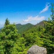
read moreThis hike will introduce you to a good cross section of the trails found in Mt. Mitchell State Park high atop the Black Mountains in Western North Carolina. Mt. Mitchell is the highest point in the Eastern United States at 6,684′, in fact six of the 10 highest peaks are found in the Blacks. The climate of the Black Mountains is more like Canada than North Carolina. Millions of years ago extreme cold enabled the plants and animals of the north to extend their range, so the botany of Mt. Mitchell is akin to a northern alpine environment....
read moreThe Cosby area in the Smokies offers quite a few long and rugged hikes from valley floor to mountain tops, including this leg-wrecker from the Cosby Campground to the Appalachian Trail on the Snake Den Ridge Trail. Even up top there are multiple potential destinations. We chose Inadu Knob and the old search & rescue helicopter pad at Deep Creek Gap for the views from Tennessee into North Carolina. Included on the nearly 4,000 foot climb are a 19th century cemetery, two creek crossings, magnificent old growth forest, wreckage from a 1984...
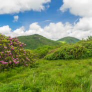
read moreJune means catawba rhododendron at Craggy Gardens. Located northeast of Asheville on the Blue Ridge Parkway, Craggy Gardens is loaded with the purple and maroon beauties. There are two short, easy trails near the Visitor Center that access mountaintops for spectacular vista views and bunches and bunches of rhodies. Craggy Pinnacle takes you above 5,800 feet for a view of the Parkway below, as well as other famous landmarks like Greybeard Mountain, the Asheville Watershed, and the twin peaks of Linville Gorge. Just the other side of Pinnacle...
read moreRobert “Booger” Palmer may have a silly nickname, but there’s one thing we can always appreciate him for. He never would allow loggers onto his 220 acre homestead in Cataloochee Valley. As a result, still today there is old growth forest that includes poplar trees with trunks six feet in diameter. The massive hemlocks have unfortunately succumbed to the hemlock woolly adelgid blight, but there are also many large, and still growing pines, oaks and maples. The loop starts and ends on the Caldwell Fork Trail, following the...
read moreLittle Cataloochee developed as an expansion to Cataloochee Valley with many of the sons and daughters of the original founders spreading their wings, albeit just a few miles away. Travel these days is limited to hiking boots and horseback, but a sense of time and place is still available through the historic restorations made by the National Park Service. Little Cataloochee Trail takes you out of the big valley, up and over Noland Mountain, and back down into the smaller neighbor to the north. In spring, this is a beautiful forested hike,...
read moreSmaller than Cades Cove on the western end of the national park, but similar in many respects, Cataloochee was named “Gadalutsi” by the Cherokee for the row upon row of mountain peaks that surround this picturesque valley. Just as Cades Cove, Cataloochee is home to many old historic structures restored by the National Park Service, as well as a wealth of wildlife and diverse botany. Cataloochee Creek runs through the valley providing fresh water and nourishment to the farmland worked by the 19th century settlers. There are a...
read moreThis short, little trail from Cove Creek to the State Fish Hatchery is often overlooked, but it will take you to some of the most gnarly whitewater on Davidson River. The trail is simple. It’s just a straight 1.1 mile shot from one end to the other, and then back. Ah, but have you ever seen a two-tiered trail? If you promise to be very, very careful on the river bank, I will tell you more about the Davidson River Trail. My brother and I hiked this trail on Saturday, May 10, 2014 beginning at 10:00AM and ending about 11:30AM. Our plan...
read moreKephart Prong is one of the many water drainages that give the Smokies its character and provide refreshing nourishment for all the flora and fauna. Named for Horace Kephart, an author who was very instrumental in helping the Great Smoky Mountains achieve national park status, this scenic mountain stream is especially inviting during the spring greening season. Particularly in May, the entire forest along the prong assumes a verdant glow that permeates the senses. The Civilian Conservation Corps was active along Kephart Prong and up Mount...
read moreEssentially a loop trail (the two ends are about 200 yards apart on Hwy 276), Sycamore Cove is a great hike for the entire family. It’s relatively easy, with only about 600 feet of elevation change, and it’s a delightful four-season hike that is a great way to start your day. The trail initially follows picturesque Starnes Branch amidst large hemlock and tulip poplar trees, then climbs moderately to a ridge along Johnson Mountain. In the fall and winter, there are some nice views, including Pilot Mountain and the lush Davidson...
read moreThe U.S. Forest Service is the greatest road builder in the world. Oft times, those forest service roads come in handy for hikers to get from one ridge to another, from one creek drainage to another, or simply from one trail to another. That’s the case with Forest Road 225 in Pisgah National Forest. FR225 tips the Caney Bottom and Cove Creek Trails on its eastern end, and the Daniel Ridge Loop on the western end. Combining the two by joining them via FR225 offers the ability to enjoy a longer loop hike. We tackled this adventure on...
read moreBackcountry wilderness. If you really want to get a taste, then this hike is for you. Starting at the remote Camp Daniel Boone, the northern terminus of the Art Loeb Trail enters Shining Rock Wilderness immediately. As you begin the nearly 2,000′ ascent to Deep Gap, on the southern shoulder of Cold Mountain, you will cross numerous streams as you hike through hardwood forest. Expect extremely rugged terrain with exceptional long-distance views and evergreen and heath vegetation as you cross from Deep Gap to Shining Rock Gap on a...
read moreWhen the Blue Ridge Parkway reopens each year in early spring, it is great to get back into the high country at milepost 420. That means the Black Balsam area and Shining Rock Wilderness. An oft overlooked trail on the west side of the wilderness is Little East Fork, a twisty path that follows the Little East Fork of the Pigeon River from Shining Rock Gap to the Daniel Boone Boy Scout Camp. Not a particularly difficult hike, it is however quite long. This hike occurred on Tuesday, April 8, 2014 beginning at 8:00AM and ending about 1:30PM. Our...
read moreThere’s a trail from Scenic Hwy 276 that parallels the Blue Ridge Parkway as it winds around 10 ridges and makes 13 easy stream crossings on its way to the Pisgah Inn on the Parkway. Buck Spring Trail eventually ends up at the site of the former hunting lodge of George W. Vanderbilt II, the father of Pisgah National Forest. In the spring this trail is alive with abundant wildflowers and songbirds. When the leaves are down in winter, it offers views of the Cradle of Forestry National Historic Site in the valley below. This hike occurred...
read moreFrom Saluda, NC the Green River Cove Road drops more than a thousand feet into the Green River Gorge to a meeting alongside the Green River. On the other side of the river is the Green River Cove Trail, at the southern boundary of the Green River Game Lands. The trail starts at Wilderness Cove and follows the river for 4.2 miles to the base of the Green River Narrows, a world class whitewater destination that is revered by kayakers all over the globe. This hike occurred on Tuesday, February 25, 2014 beginning at 10:45AM and ending about...
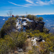
read morePinnacle Park is an 1,100 acre tract of land owned by the town of Sylva in Jackson County, NC that was previously used as the community watershed. In 1991 it was leased to the Pinnacle Park Foundation for developing hiking trails that pass by streams, waterfalls, and beautiful long distance vistas. The Pinnacle, where the park got its name, is a large rocky outcropping that rises above 4,900 feet and offers 270° views of the town, the Plott Balsams, the Great Balsam Range, and even Clingmans Dome in Great Smoky Mountains National Park....
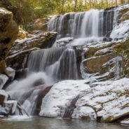
read moreThis hike is found in a remote corner of the Green River Game Lands near Saluda, NC that enables you to enjoy beautiful waterfalls. Little Bradley Trail follows Cove Creek along its path to an eventual meeting with Green River, but before it gets there, it tumbles over the three-tiered cascade at Little Bradley Falls. I happened to catch it a couple days after a snowfall, so the white enhanced the scene even more. This hike occurred on Friday, January 31, 2014 beginning at 11:30AM and ending about 2:00PM. My plan was to take the Little...
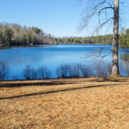
read moreDown in the far southern section of DuPont State Forest is the Reasonover area, near the community of Cedar Mountain. Home to several trails and a couple of reservoirs, like most of DuPont, Reasonover is a great place to go hiking. Especially if you want to stay away from the high country during the winter season, Reasonover is less than 3,000 feet, so you’re a lot less likely to encounter snow and ice. The Reasonover Creek Trail is the hub, with many other trails and forest roads branching out in every direction. This hike occurred on...
read morePanthertown Valley in Nantahala National Forest is known for its stunning mountaintop vistas, but also for a numerous and varied assortment of waterfalls that run the gamut from slides, to cascades, to ledge and plunge. Six of those falls are along Greenland Creek, including the feature cascade Greenland Creek Falls. Beyond this tall waterfall, the Greenland Creek Trail has become overgrown and difficult to follow, but there are two more waterfalls further upstream. Halfway Falls and Carlton’s Falls are definitely worth the effort to...
read more I am Jeff Clark, founder of Internet Brothers, producer of this blog, and passionate about hiking. I live in Western NC near the Blue Ridge and Great Smoky Mountains. Pisgah and Nantahala National Forests are just out my door, so the content will focus on these areas, but let me know what you would like to see on the site.


Copyright © 2011-2023 Internet Brothers. All Rights Reserved. ISSN 2324-6057
Designed by Elegant Themes | Powered by Wordpress | Logo by Design Aspirations