
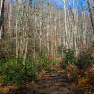
Just southeast of the Cradle of Forestry in Pisgah National Forest lies the Avery Creek area, a beautiful hardwood forest with plenty of water and a hidden pair of waterfalls known as Twin Falls. Access to the falls is via the Buckhorn Gap Trail, an easy to moderate track that first follows Avery Creek, then turns north alongside Henry Branch. The forest management work...
Learn More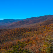
Pilot Rock is another of the granite plutons found in the Pisgah Ranger District of Pisgah National Forest. Not as spectacular as it’s more famous cousin, Looking Glass Rock, Pilot still offers remarkable views of the Blue Ridge Parkway and national forest, including the Cradle of Forestry National Historical Site. It’s a short mile climb of almost 700 feet...
Learn More
Think of Wilson Creek as Linville Gorge lite. A long, rugged wilderness gorge running from the nearly 6000′ mountain peaks at its north, Wilson Creek shares many similarities with its bigger brother to the west. Wilson Creek was named a National Wild and Scenic River in August, 2000. The gorge area is a haven for recreation including hiking of course, but also fun...
Learn More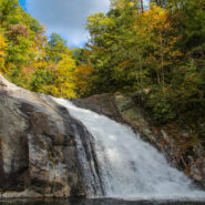
One of the highlights of the Wilson Creek Wild and Scenic River area is Harper Creek Falls. Located in the Grandfather Mountain Ranger District of Pisgah National Forest, this three-tiered falls is a fun place to swim, slide and dive — but the rugged terrain makes for a difficult and dangerous access. The Harper Creek Trail is easy enough. With the exception of a...
Learn More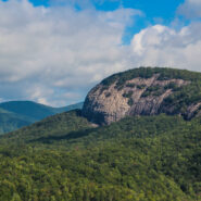
The always popular Cat Gap Loop Trail is a jumping off point for many great hikes within the Davidson River area of Pisgah National Forest. Included among them is the picturesque John Rock, one of the area’s plutons that stand over the recreation area. With views of the Fish Hatchery, Looking Glass Rock, Pilot Mountain and the ridges that run to Graveyard Fields,...
Learn More
Another of the myriad of ridge and gap trails from North Mills River to the Blue Ridge Parkway. Bad Fork Trail follows its namesake creek from Forest Road 5000 to Bent Creek Gap at mile 400 on the Parkway. This is a four mile round trip that can be extended by continuing on the Mountains to Sea Trail on the north side of the Parkway. Only moderately steep, this is a nice...
Learn More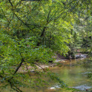
Section 1 of the Art Loeb Trail is in Pisgah National Forest near Brevard, NC overlooking the Davidson River Recreation Area. The North Slope Trail is a loop contained within the boundary created by the Art Loeb and the river. Between the two trails is a connector. Combining the two via the connector makes an 8-mile loop that takes in a large portion of the forest above...
Learn More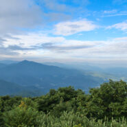
Named after the Biblical mount where Moses first saw the Promised Land, Mt. Pisgah is the landmark that gave Pisgah National Forest its name. Located on the border of Buncombe and Haywood counties in NC, close to the point where Transylvania and Henderson meet them, the mountain is easily accessible via a hiking trail from the Blue Ridge Parkway. Mt. Pisgah is topped...
Learn More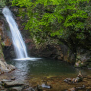
Hidden deep in the woods between Courthouse Ridge and Brushy Ridge in western Pisgah National Forest, Courthouse Creek makes a dramatic plunge through a narrow chute into a natural amphitheater of bedrock, cascading 45 feet into a cold crisp pool. Courthouse Falls is one of the best kept secrets in the “Land of Waterfalls.” Beautiful for its solitude as well...
Learn More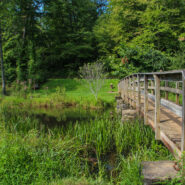
Located in the Bent Creek area west of Asheville, the Lake Powhatan Recreation Area is a suburban fun place for family activities including hiking, biking, fishing, swimming and jogging. Adjacent to the North Carolina Arboretum and part of the Bent Creek Research and Demonstration Forest in Pisgah National Forest, the recreation area contains several miles of trails...
Learn More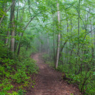
Bracken Mountain Preserve and Recreation Area is 395 acres of forested land owned by the town of Brevard in Transylvania County, NC. This municipal preserve is due west of downtown and adjacent to Pisgah National Forest and the Brevard Music Center. The town secured approval from the National Forest Service to build a connection with the established trail system, and to...
Learn More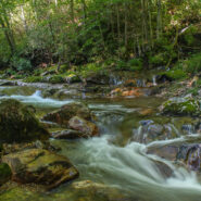
The southeast corner of Shining Rock Wilderness is filled with rivers, creeks and streams tumbling down from the mountains that rise above 6000 feet in the high country. Included among these waterways is the East Fork of the Pigeon River, otherwise known as Big East Fork. A trail follows the river from Hwy 276 to the confluence with Greasy Cove Prong and beyond. This Big...
Learn More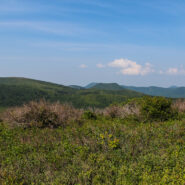
Milepost 420 on the Blue Ridge Parkway is where you will find Black Balsam Road. It’s a short drive to a spruce forest where the Art Loeb Trail crosses the road and heads up onto the balds. This is North Carolina high country. There are several mountains greater than 6000 feet with treeless summits, affording spectacular 360° views of the surrounding Blue...
Learn More
Nestled in the woods of Pisgah National Forest in Asheville, the North Carolina Arboretum is a 434 acre public garden located within the Bent Creek Experimental Forest. Set amid rolling hills just off mile 393 of the Blue Ridge Parkway, the Arboretum offers more than ten miles of groomed hiking trails that are suitable for all ages. Home to one of the finest, most unique...
Learn More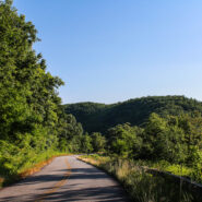
This is a two-part hike with a short drive on a forest service road in between. Both the Case Camp Ridge Trail and the North Face Trail start on Forest Road 475B in Pisgah National Forest. The first climbs 1000 feet in 1.7 miles to the Blue Ridge Parkway near Cherry Gap at mile 416. It’s a short walk from the trail to the Cherry Cove Overlook and a close-up view of...
Learn More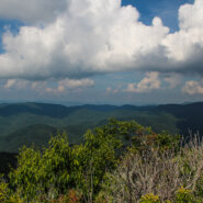
Pilot Mountain stands 5084 feet above the western edge of Pisgah National Forest, near the Blue Ridge Parkway and Looking Glass Rock. There are three ways to get to its summit, but the one I enjoy most is the section of the Art Loeb Trail from Gloucester Gap along Forest Road 475. It isn’t particularly long, but it is quite strenuous. You will get your exercise...
Learn More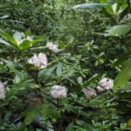
Another of the myriad of hikes along Forest Road 475 in Pisgah National Forest, this two-parter is near the Fish Hatchery and Pisgah Center for Wildlife Education. First we took a short trip up Forest Road 475B to Slick Rock Falls, then hiked to the base of Looking Glass Rock. The climbers love this area and we encountered some when we reached the base. The main hike was...
Learn More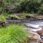
The Riverside Trail along the South Fork of Mills River in Pisgah National Forest is a great opportunity for boys to be boys, and girls to laugh at them, as the trail fords the river several times. You’ll get to wade in a crisp, cool mountain stream up to your knees as you negotiate the current and the smooth, slippery rocks on the bed. Enjoy the peaceful sounds of...
Learn More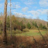
North Mills River Recreation Area in Pisgah National Forest, along with its brother at South Mills River, has a rich trail system. It covers the Pisgah Ridge at the Blue Ridge Parkway down to the North Mills River. A combination of trails leading from the Trace Ridge Trailhead at the recreation area go up, over, and around Coffee Pot Mountain on the way up to the...
Learn More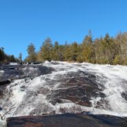
Transylvania County, NC is known as the “Land of Waterfalls,” and for good reason. There are more than 250 waterfalls in the county, with many of the most spectacular falls in the heart of DuPont State Forest. Included among those are Bridal Veil and Grassy Creek Falls, both classic slide waterfalls that carve their way over large granite slabs. DuPont also...
Learn More
Looking for a hike that includes streams and rivers, hardwood and conifer forests, plentiful rhododendron, and some climbing for good measure? Then the trails along South Mills River that embark from the Turkeypen Trailhead may be just the ticket. Situated in the southeastern corner of Pisgah National Forest, the Mills River Area is the largest in the Pisgah Ranger...
Learn More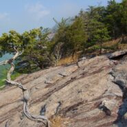
Perhaps the most popular hike in the Pisgah Ranger District of Pisgah National Forest, the Looking Glass Rock Trail is a good 3-mile leg stretcher to the top of the famous pluton. Probably not the most scenic hike is the area, but definitely popular because of ease of access, and a little less difficulty than some of the steeper monoliths. Looking Glass Rock is home to...
Learn More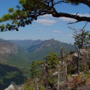
Most of the attention in Linville Gorge is focused on the northern features. There are more trails, higher peaks, and family recreation areas. But the south gorge is every bit as compelling and beautiful, with spectacular panoramic views up the gorge and westward to Pisgah National Forest and the Blue Ridge Mountains. Shortoff Mountain is a thousand feet lower than its...
Learn More
Kind of an unusual name for the mountain this trail is named after, but it is at 5,200 feet, so the snow comes earlier in the season, and more frequently than in the valleys below. North of Asheville, NC on the Blue Ridge Parkway, this hike is in the Craggy Gardens area. There are splendid views of the Great Craggy Mountains and the Black Mountains from the three summits...
Learn More
Flat Laurel Creek is in the area just north of the Pisgah Ridge and in between the Shining Rock and Middle Prong Wildernesses. It drains from Sam Knob and Little Sam Knob and runs to the West Fork of the Pigeon River. The trail that bears its name starts at the headwater and travels 3.7 miles around the west side of Little Sam until it meets Hwy. 215 and joins the...
Learn More
Looking at a trail map or topographic map, the area of this hike within Shining Rock Wilderness can be somewhat confusing. There is the Greasy Cove Prong, a creek that runs off of the Grassy Cove Ridge. The trail is called Greasy Cove, but it starts/ends at Grassy Cove Top. I think the guys who named the area may have had a touch too much huckleberry wine. Regardless of...
Learn More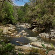
Explorer William Linville and his sons were scalped by Indians in 1766 in what would eventually become known as Linville Gorge. I do believe I’d be fine with going through life not having anything named for me. The Linville Gorge Wilderness in Burke County, NC was one of the first protected areas in the country under the Wilderness Act of 1964. I’ve enjoyed...
Learn More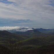
Frequently. That is how many times I have done this hike. So many, I’ve lost count. I love the western North Carolina high country, and this area along the Blue Ridge Parkway known as Black Balsam has nearly a dozen peaks over 5,800 feet elevation, with Black Balsam Knob being the highest at 6,214. This area has some of the highest hiking on the Parkway. Many of...
Learn More I am Jeff Clark, founder of Internet Brothers, producer of this blog, and passionate about hiking. I live in Western NC near the Blue Ridge and Great Smoky Mountains. Pisgah and Nantahala National Forests are just out my door, so the content will focus on these areas, but let me know what you would like to see on the site.


Copyright © 2011-2023 Internet Brothers. All Rights Reserved. ISSN 2324-6057
Designed by Elegant Themes | Powered by Wordpress | Logo by Design Aspirations