The Appalachian Trail (A.T.) will remain accessible to the public across the approximately 700 miles managed by the National Park Service (NPS) and over 800 miles managed by the U.S. Forest Service (USFS).
A.T. visitors will be able to access and hike on the Trail itself, but no visitor services, maintenance or other management activities will be conducted, and emergency and rescue services will be limited.
Any entry onto NPS and USFS property during this period of a federal government shutdown is at the visitor’s sole risk.
All NPS and USFS volunteer programs are also suspended. The Appalachian Trail Conservancy (ATC) will not be able to engage with volunteers in activities on the Trail, Trail facilities or Trail lands.
National parks are treasured by Americans nationwide. They not only protect our national heritage, but they are important to local economies and the federal government has a responsibility to keep them both open and adequately funded. Congress and the federal government should together in the best interests of the country to re-open promptly.
For more information on the shutdown’s effects on the A.T., visit appalachiantrail.org/updates.
During the 21-day government shutdown of 1995-1996, an enormous blizzard left up to three feet of snow in Virginia’s Shenandoah National Park—and no one was there to shovel the parking lots. But that was the least of Bill Wade’s problems. The park’s superintendent at the time, Wade knew that several campers had entered the Shenandoah backcountry before the shutdown. “They were caught back there, and we couldn’t get to them because we had limited staff,” he recalled. “Fortunately we didn’t have any injuries or fatalities, but it could have been a real situation.”
Department of Interior Secretary Ryan Zinke is reportedly drafting a plan to make sure the parks and monuments remain open if there’s a shutdown. People would still be able to birdwatch in the Everglades and hike in Death Valley—both of which are in peak season—but there wouldn’t be any non-essential National Park Service staff available to help them. That means no educational guides, no maintenance workers, and no park rangers aside from law enforcement. Campground sites, full-service bathrooms, and visitors centers would be closed.
Protecting visitors from danger is one worry, but so is protecting the parks from the visitors. “The biggest question in my mind is protection of resources,” Wade said. National parks are protected for a reason, the larger ones often containing sensitive ecosystems, endangered species, coveted petrified wood, and artifacts. Poachers and vandals may see an opportunity in the lack of trail guides and other staffers who monitor the parks. “Archeological resources become more vulnerable for looting, the risk of illegal hunting increases,” Wade said.
As a means of attracting attention, staging accidents on various mountain ranges is not overly common. But that is likely to be of little consolation to the crews who have raced to the aid of Michael Cuminskey, a serial mountain rescue faker with a penchant for taking a selfie as he is winched to safety.
Mr. Cuminskey’s antics have cost tens of thousands of pounds, with unnecessary rescues from mountains in Snowdonia, the Lake District and the Scottish borders, a court heard.
The 23-year-old, from Darlington, UK pleaded guilty to causing a public nuisance after staging accidents in the Lake District in March 2016 and three days later at Llanberis in Snowdonia. The estimated cost of the coastguard rescue helicopter call-out in Snowdonia came to £33,000.
Brett Williamson, prosecuting, told Caernarfon crown court Cuminskey had started behaving “irrationally” while climbing in the Vivian Quarry, Llanberis, and was found by a man at the bottom of a 130ft drop, claiming his back was painful.
Twenty mountain rescue team volunteers were assembled but as Cuminskey was winched aboard the helicopter he tried to take a mobile phone selfie.
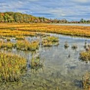
As avid outdoorsy people, we are always looking for hidden-away spaces to explore that aren’t teeming with other people. During visits to Cape Cod, you will find an array of natural areas. The secret is talking to the locals, who are always willing to let you in on the local gems, those places still undiscovered by your average visitor.
For example, Allens Pond Wildlife Sanctuary is a nature area that spans hundreds of acres. In addition to being a protected area for wildlife, is a wonderland for hikers. With its system of 7-miles of trails, Allens Pond is located near the Westport shoreline and offers stunning views of Buzzards Bay and the Elizabeth Islands.
Trails run through a variety of environments including farmland, beach, meadow, salt marshes, and forest. Bird lovers will especially appreciate the wide variety of protected birds. Some 300 species of birds have been sighted at Allens Pond. In this area, migratory birds spend stopovers during their long journeys.
Allens Pond seems to be less frequented than other areas on the Cape. Perhaps due to its status as a protected nature area, where activities like horseback riding, picnicking, and swimming are prohibited, it is less popular with the public.
Here are additional noteworthy hiking areas on Cape Cod…
In the Australian countryside, it is not unusual to stumble across the relics of a vast abandoned rail network that once connected the nation before cars and trucks replaced trains as the preferred mode of transport.
These remnants of a forgotten past can range from rail tracks hidden in farm paddocks to majestic stations overlooking silent platforms that have not been used in decades.
This ghost rail network spans thousands of kilometres – a reminder of the population’s shift over the past century from rural townships to bustling coastal cities.
But there has been a growing push in recent years to find new uses for the old lines, particularly as so-called “rail trails”, where the routes are converted into bike tracks, hiking trails and horse-riding paths. Meanwhile, old stations have been given new uses, including as cafes or museums.
The aim is to preserve the heritage while attracting tourists and visitors to remote areas that are often otherwise inaccessible.
The federal and Queensland state governments last year approved funding to complete the country’s largest trail, a 161km track near Brisbane. The trail is due to be completed by June along a line that was built in the 1880’s and closed almost 30 years ago.
If you’re among the thousands who will attempt to conquer a long-distance hiking trail in its entirety within the 2018 hiking season, then you’re probably already busy training, saving, planning, and steeling yourself for some serious communing with nature. In the United States, the term “thru-hiking” is most commonly associated with the Appalachian Trail (AT), the Pacific Crest Trail (PCT), and Continental Divide Trail (CDT)—although there are plenty of other satisfying end-to-end hikes to tackle.
Hikers hitting America’s most sought-after thru-hike typically head to the AT’s southernmost point in Georgia within three weeks on either side of the spring equinox, so as to complete their 2,189-mile trek before October, which is when its northern terminus, Mt. Katahdin in Maine, closes. Northbound PCT hikers tend to journey to the Mexican border in April or May, with hopes of arriving in Canada, 2,660 miles later, in September. Tackling the CDT? Experts suggest you start the 3,100 miles spanning Antelope Wells, New Mexico, and Glacier National Park between mid-April and mid-May. (You don’t have to take the northbound approach, but most thru-hikers opt to start from the south.)
Before setting out on what is by all accounts a completely transformative experience, you’ll need to muster up some serious courage—along with reliable gear, good maps, and moral support. Planning a thru-hike can be seriously daunting, but keep in mind, you’ll experience profound rewards—just think of the beneficial effects of all that flora, fauna, exercise, trail bonhomie, toughening, and self-reflection. Plus, you’ll get to use the coveted #thruhiker hashtag when posting jaw-dropping landscapes and/or anecdotes worthy of a cocktail party at trail angel stops.
Four students in the Texas A&M Aggie Corps of Cadets raised thousands of dollars for charity after hiking more than 1,000 miles in two weeks.
Four cadets from Company H-1 decided to spend 13 days of their holiday break hiking from El Paso to Death Valley, California. Sophomore Hunter Birt, sophomore Jordan Rogers, junior Sebastian Brown and sophomore Ian Morrow decided to use this hike to raise money for the Special Operations Warrior Foundation, which provides financial aid, tutoring and counseling to the dependents of veterans who died in the line of duty.
From Dec. 27 to Jan. 8, the students managed to draw attention to their trek and raise $5,200 in donations for the nonprofit. Though they would sleep at friends’ homes along the way, they sustained several injuries and endured trying weather, according to a press release from TAMU.
“Something that was inspirational was the support that many people gave to the cause,” said Birt. “It was especially gratifying to see that Americans were coming together to support those in need. The beauty of humanity and unification is what truly inspired us to keep going.”
To learn more about the Special Operations Warrior Foundation, visit specialops.org.
There’s no doubt about it: Hiking is having a moment. By now, we know spending time in nature comes with tremendous benefits. It has a scientifically proven anti-inflammatory effect on the body, it promotes a healthier microbiome, and Japanese Forest Bathing—or shinrin-yoku—has been associated with reduced stress, lower blood pressure, and a stronger immune system.
Exercise has a similar effect on the body. From greater feelings of happiness to reduced heart disease risk, you’d be hard-pressed to find a medical professional who doesn’t recommend regular exercise. And while many of us have turned to our local yoga studios for a dose of calm movement, 2018 has brought a resistance against spending so much of our time inside, and that includes for workouts.
“It’s only natural that there’s a backlash against our 95 percent indoor lifestyle, eight daily hours of social media consumption and indoor boutique gym workouts.” While the benefits of yoga are tremendous and it’s not likely to ever go away, experts say hiking is moving to the forefront as the go-to stress-busting, peaceful workout.
Perhaps the only thing better is combining the two. Add your daily yoga routine to your next hike. Do it outdoors.
In honor of Martin Luther King Jr. Day, national park units across the country will offer visitors free entrance into the parks on Monday, January 15, 2018.
Martin Luther King, Jr. day will be the first of four fee-free days this year. Those days include April 21 to celebrate the start of National Park Week, September 22 for National Public Lands Day and November 11 in honor of Veterans Day Weekend. During these dates, all National Park Service sites that charge an entrance fee will offer free entrance to all visitors.
Fee-free days give more families opportunities to visit national park sites and enjoy our country’s historical, cultural and natural resources. In addition to fee free days, the Every Kid in a Park program provides all fourth grade student with a free annual pass to national park sites. Active duty military and citizens with a permanent disability also have free access to national park sites.
Park visitors are reminded that the fee-free designation applies to entrance fees only and does not affect fees for camping, reservations, tours, or use of concessions. Park entrance stations will have Interagency Senior and Annual Passes available for those who wish to purchase them. Those who plan to spend time in the park beyond January 15 will need to pay the regular entrance fee for the remainder of their stay.
For more information about NPS fee-free days, visit https://www.nps.gov/planyourvisit/fee-free-parks.htm.
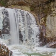
The curvy, two-lane Forest Heritage Scenic Byway, aka U.S. 276, which runs along the Davidson River and through the heart of Pisgah Ranger District, looked more like a July 4 traffic jam over the weekend than a cold and lonely winter day.
The lure during the chilly temperatures? The rarely seen frozen Looking Glass Falls, a 60-foot-high stunner that can be easily accessed by pulling off the road.
But simply Snapchatting from the safely built overlooks wasn’t enough for most of the throngs of people, according to U.S. Forest Service rangers.
Many people slipped or wiped out on the thin ice coating the steps to the base of the falls, and also fell in the moving water under the ice in the waterfall pool.
People were seen straddling the river to get a closer look at the falls, which was frozen in cauliflower-like bunches on its sides but was gushing plenty down the center line.
Some visitors took things a step further and tried to walk on the floating chunks of ice in the Davidson River, only to fall through.
Forest Service spokeswoman Cathy Dowd said there were no serious injuries. But even short periods of time in the frigid water can lead to hypothermia, a dangerous lowering of body temperature, and drowning.
An almost forgotten railroad could become a big part of a new trail for hikers, bicycle enthusiasts, and horseback riders that are interested in exploring the mountains and forests of Mercer and Summers counties in West Virginia.
Mercer County and neighboring Summers County are working on plans to develop hiking trails and water trails. The hope is that an old railroad right of way going through part of Mercer County will form a connection with trails in Summers County and beyond. This former railroad line was mostly forgotten until its existence became part of negotiations in the 1990s.
“That railroad line and the right of way for it connects Mercer County and Summers County at Pipestem State Park,” the Mercer county commissioner said. “It also extends out to Camp Creek State Park; it’s a network. So we’re working together with Camp Creek State Park, Pipestem State Park and Summers County to develop a larger network of hiking, mountain bicycle trails and equestrian trails on this way.”
Summers County is working to develop its trails, too. Their County Commissioner said he was looking at the Great Eastern Trail, which parallels the Appalachian Trail in Giles County, Va. The Great Eastern Trail and the Mary Draper Ingles Trail run to Bluestone Lake together. The Mary Ingles Trail then goes down the New River while the Great Eastern Trail turns up the Bluestone River Gorge.
Eddie Boyd spent months preparing for a 2015 hike of the Appalachian Trail, only to confront a sobering realization just 20 miles in: He wasn’t ready.
At a shelter in Maine, 3 miles into the daunting Hundred-Mile Wilderness, dehydration and self-doubt had set in.
Boyd contacted his uncle, who was staying with his parents at a cabin in nearby Baxter State Park, to pick him up. A few days later, he was back home in Columbus, Ohio.
“I remember being absolutely devastated at the decision to turn around,” he said. “I had been planning this trip for over a year, and I hated that it may end only 20 miles down the trail.”
Boyd didn’t give up, though. He just needed time to regroup. On June 28, 2015 — 15 days after quitting the trail — he was back out.
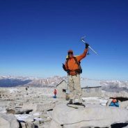
Thus began a three-year cross-country adventure that ended in November 2017 in a rare accomplishment: The 20-year-old completed the triple crown of hiking. “My self-confidence is just through the roof,” said Boyd.
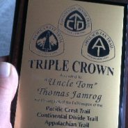
The triple-crown distinction is reserved for those who have hiked the entire Appalachian Trail, Pacific Crest Trail and Continental Divide Trail, all three of which have been designated a National Scenic Trail by Congress. The three routes span 22 states and a combined 8,000 miles.
When Tom Jamrog was a student at the University of Massachusetts in the early 1970s, a friend gave him the idea of hiking the Appalachian Trail. Jamrog put the quest on his bucket list.
A move to Midcoast Maine to build a home in Lincolnville with his wife, Marcia, in 1977 and then raising a family and working as a school psychologist in Rockland put off the long-distance hike. But when Jamrog finally got around to the Appalachian Trail decades later, at age 57, he didn’t stop there.
Jamrog completed the Appalachian Trail in 2007, then turned that quest into a late-in-life odyssey by completing another six major long-distance trails over the next 10 years. Now 67, he’s not done.
In 2010, Jamrog completed the 2,650-mile Pacific Crest Trail. In 2013, he traversed the 3,100-mile Continental Divide Trail from Canada to Mexico, believed by many to be the world’s most arduous long-distance trail. Between these three major hikes, Jamrog hiked the 24-mile wilderness trail called the Fundy Footpath in New Brunswick (2008), the 272-mile Long Trail in Vermont (2011); and the 186-mile East Coast Trail in Newfoundland (2017).
In addition, he went to Europe in 2016, where he and Marcia hiked the 382-mile Camino de Santiago trail in Portugal. Originally a path taken by pilgrims in the Middle Ages to the shrine of St. James, the Camino trails have become a popular group of footpaths as well as a cultural experience. Jamrog said the flat, coastal trail gave him another perspective of the possibilities ahead.
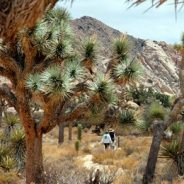
Part of the attraction of Joshua Tree National Park is the contrast in landscape and environment. The park’s landscape exhibits considerable changes as the higher elevations are a mountainous ecosystem and, from the east to the west, the Mojave descends into the hotter and drier Colorado Desert.
The western part of the park is filled with Joshua Trees that stimulate a visitor’s imagination with shapes resembling stick figures. The trees (actually yuccas) are pollinated only by yucca moths that lay eggs in the flowers. The larva feed on seeds as the fruit matures. The average lifespan of the plants is about 150 years, although there is concern a warming climate is resulting in much shorter lives at lower elevations.
The park was established in 1936 as a national monument and upgraded in 1994 to national park status at the same time 234,000 acres of land were added. The 1994 expansion resulted in new boundaries with elevations that range from 900 feet to more than 5,000 feet and cover three major ecosystems. About 75 percent of the park’s nearly 800,000 acres are designated as wilderness.
Despite annually welcoming nearly 1.6 million visitors to a park one third the size of Yellowstone, Joshua Tree National Park never seems to be crowded. The lack of congestion is in part due to visitation being more evenly spread throughout the year. The park enjoys an extended season that runs from early fall through late spring. Only hot summers deter visitation to the southern California desert.
The park’s main roads are laid out in a wiggly Y-shape with entrances in the northwest, north and south with visitor centers near each entrance. Most visitors spend the majority of time in the northern and western sections of the park. These are scenic areas that serve as home for the Joshua Trees that prefer the cooler climate of the Mojave Desert.
Mention Colorado Springs and you probably think of Pikes Peak, the highest mountain in the southern Front Range of the Rockies, or the Broadmoor Hotel, the historic resort nestled in the hills overlooking the city.
But what happens when you take both of those out of the picture, plus most of the other tourists?
Colorado Springs is built around hiking, literally. The city is surrounded by 1,200 acres of open spaces designed to be part of the community. These parks are not the tended gardens you’d expect back East, in New York or Savannah, Ga. They are often swaths of undeveloped land teeming with deer and an occasional black bear.
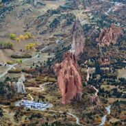
One favorite open space is the Garden of the Gods, a National Natural Landmark with miles of hiking trails and 300-foot sandstone formations. On a weekend, you can stroll through here and watch climbers hone their skills on Cathedral Rock’s vertical face. The Garden also takes a great picture from almost any angle.
Perhaps the best part of Garden of the Gods is that admission is completely free. But it’s not the only free activity in town.
An exceptional country, in its own and in others’ view, Japan has throughout history been isolated, an island nation out on the periphery of Asia. Heavily influenced by China for centuries, it withdrew from the world from the 16th to the mid 19th Centuries, its ports closed to (almost all) foreigners.
This isolation has produced a unique and fascinating culture and an idiosyncratic and much-admired aesthetic: its temples and gardens, its ceramics and art, its poetry and its cuisine are loved and venerated around the world. These can be hard to reconcile with the aggressive militarism of the early C20 and its horrendous conduct during WW2, which is still remembered around Asia.
With a population of 126m crammed into the coastal strips of what is a mainly mountainous landscape, there is a huge contrast between Japan’s image of crowded megalopolis, with the often dreary monotony of its suburbs, and the remote beauty of its mountains, its icon Mount Fuji the most famous specimen of a violently shaped landscape.
Japan’s Alps rival those of Europe and its islands and quiet backwaters are of a different world. It extends for around 3,000km, from the sub-arctic north of Hokkaido to the sub-tropics of Okinawa, with a huge variety of biozones and vegetation and animal life as a result, from bear to various species of deer to the endemic serow to more than 500 species of bird.
Japan’s geology, and indeed its existence, result from its sitting astride the junctions between no less than four tectonic plates on the Pacific Ring of Fire, hence its earthquakes, tsunamis (a Japanese word of course), dramatic, rugged mountains and plethora of volcanoes.
What isn’t widely known is that Japan has some of the world’s best walks, hikes and treks. Walking, hiking and trekking options are so varied that everyone’s taste and energy levels can be met.
Wooded hillsides, craggy ridges and wheeling birds of prey are a world away from Hong Kong’s famous skyscrapers but the city’s country parks are a necessary balm for its stressed out residents.
With some of the world’s highest property prices, many can only afford tiny apartments, some living in infamous “cage homes” big enough only for a bed.
Hong Kong’s fast-paced lifestyle and long working hours also take their toll.
Fortunately, within easy reach of the densely packed tower blocks and traffic, there is an extensive network of hiking trails which snake over hundreds of peaks across the territory and along its coastlines.
Forty percent of Hong Kong is protected country park and nature reserves, amounting to 443 square kilometres, drawing hikers, runners and campers all year round.
The country parks are a very valuable asset to Hong Kong, not just for now, but for future generations.
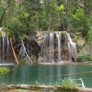
The U.S. Forest Service has released a draft of the environmental assessment of its proposed plan for visitor management of the popular Hanging Lake near Glenwood Springs.
An iconic Colorado landmark, the lake in the White River National Forest is both a popular destination for hikers and photographers, along with being a spur-of-the-moment stop for people passing by on I-70 as it winds through Glenwood Canyon. The site has seen tremendous increases in visitors over the last several years — 2017 brought 184,000 visitors, a 23-percent increase over 2016.
The increase has brought with it a host of problems, the biggest being parking at the trailhead, which is now too small for the number of cars that stop there, especially during the busiest times of the year. During recent peak seasons, signboards on I-70 warned that the lot was full and the area closed, and the forest service and CDOT worked to restrict access, but problems persisted with cars parked in no parking zones and backed up onto I-70.
And all those cars brought hikers, which increased the wear and tear on the narrow, steep trail that was designed for far less use. With that and graffiti and people misusing the lake and trail, the forest service has not been able keep up with maintenance of the trail or curb the environmental damage.
In its plan, the forest service has proposed a number of measures to decrease the usage of the trail to get control of the situation. The plan calls for restricting the number of visitors to 615 per day, year round. From May to October, when usage peaks, there will be no public parking at the trailhead — visitors will be required to take a shuttle to and from the site, the details of which are still to be determined. All visitors will also be required to purchase a pass in advance, meaning that the days of the spontaneous hike to the lake will be no longer.
If you can’t get on the trail at Hanging Lake, here are other Colorado hiking locations that may appeal to you.
 I am Jeff Clark, founder of Internet Brothers, producer of this blog, and passionate about hiking. I live in Western NC near the Blue Ridge and Great Smoky Mountains. Pisgah and Nantahala National Forests are just out my door, so the content will focus on these areas, but let me know what you would like to see on the site.


Copyright © 2011-2023 Internet Brothers. All Rights Reserved. ISSN 2324-6057
Designed by Elegant Themes | Powered by Wordpress | Logo by Design Aspirations