Hiking is a wonderful thing. It’s great exercise and it’s good for the psyche. But with more newbies hitting the trail, and concerns about social distancing, it’s time to take a fresh look at trail etiquette.
Many people aren’t riding together anymore due to COVID, so if four friends go hiking, they each drive a car. “This, along with more people seeking outdoor recreation, has resulted in a parking problem at the trailheads,” says a mountain guide. We’ve heard stories of 2-mile backups at popular trails, and trailside parking lots full by 7 a.m. or earlier.
What can you do? “Go wicked early,” he suggests. Bonus: You’ll get to see a nice sunrise. That’s better than arriving late and taking a chance on hiking out of the woods in the dark. And always have a Plan B: If the parking lot is full, go to another location. Weekends are obviously busiest, but midweek crowds have been substantial during the pandemic as well.
In a perfect world, we would all respect each other’s personal space. That doesn’t always happen on the trail. “Some people are trying to keep their distance on the trail, some hold their breath, and some don’t care — and don’t care that you care,” he says.
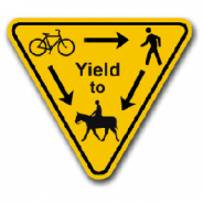
Typically, a group of hikers should yield to an individual on a trail, and the person who’s ascending has the right of way (meaning, descending hikers should make way for them). Newbies may not realize this, and you may have to get off the trail to avoid other hikers. But going off the trail can harm the environment.
What to do? “Aim for rocks and roots and open drainages,” Cherim says. “Don’t walk on mosses and alpine vegetation. Walking on roots doesn’t hurt trees, but walking on the soil around trees causes damage.”
OK ladies, whether you’re a seasoned hiker or new to the trails, it doesn’t take long to realize that the right gear, from hiking boots to hydration packs, will make a trip exploring the great outdoors much more comfortable.
Same goes for apparel — as we creep closer to the fall and winter seasons, it’s just about time to exchange your favorite shorts for a pair of durable, comfortable leggings that will keep up with you on the trails.
This is a review of six pairs of leggings that are specifically designed for hiking and climbing, meaning that they include helpful features like water- and abrasion-resistant material, reinforced panels, and secure zippered pockets.
Features to look for include highly compressive fabric and an internal drawcord for a secure fit.
Some are made with a double-fabric overlay, which prevents snags when climbing over rocks and hiking rough terrain. Plus, both zippered and Velcro pockets will keep your essentials secure.
Prices range from $40 all the way up to $175.
On a recent hike, John Gallen Jr. came across an injured hiker. The hiker had stumbled, fallen and was bleeding. With his first aid kit, Gallen was able staunch the bleeding from what appeared to be a small severed artery. He helped the hiker to safety. Falls can happen to anyone on the trail, but being prepared can make a difference.
Gallen, an experienced hiker, said the first aid kit is something he never hikes without, whether it’s a familiar local stroll or a trek through the Andes or Himalayas. “I think she was younger than some of the Band Aids in that kit,” said Gallen.
For Lisa Peterson, a board member of the Horse-Shoe Trail Conservancy, waterfalls are a lure to hiking across the United States, Canada, Norway, Sweden, Germany and Switzerland, as well as Italy and Asia and Latin America.
“When I’m on business travel, my hikes are alone,” said Peterson of Brecknock Township. “So this leads me to offer some advice on the importance of having a plan.” Peterson said hiking is an opportunity to be with nature.
“It’s peaceful,” she said. “Sometimes one can hike an entire day and see no other person. And in many of these places, they are so remote that cellular phone service doesn’t exist. So a hiker needs to think along the lines of being self-reliant.”
The moment your stomach starts rumbling and your energy levels take a nosedive, your instinct’s to comb through your snack stash for whatever — be it a sugar-filled granola bar or bag of pretzels — excites your tastebuds. But if you’re trekking up a mountain or through a secluded pine tree forest, you’ll need to be a little more strategic with your snack choices — and when you eat them in the first place.
In fact, hikers should consider eating a snack every 60 to 90 minutes between meals, depending on the intensity of the hike, says a food planning expert. “This is because a hiker can be at risk of burning through their glycogen stores — aka hitting the wall or ‘bonking’ — within one to three hours of hiking if the body isn’t fueled adequately,” she explains.
These glycogen stores — or the stored form of glucose (a type of sugar converted from carbohydrates) in your liver and muscles — act as a reliable source of energy while you exercise. The more intense the activity, the more quickly your stores are used up. But if your glycogen stores get too low while you’re exercising, your muscle cells can’t produce enough ATP. The result: You feel run-down, fatigued, and more inclined to lie down for a nap than to climb that next peak.
To keep your energy high throughout your trek, she recommends loading up on hiking snacks that boast a balance of carbohydrates, which provide the body with that essential glucose; fats, which act as slow-burning fuels that keep your body moving after you metabolize the carbs; and protein, which help build and repair muscle, she says.
When Mandy Keathley began hiking the John Muir Trail, she expected the over 200-mile journey to take about 18 days.
The 32-year-old hadn’t made plans for the summer. So when she got a month off from work, she figured it was the perfect time to spend a few weeks in the open air. She packed a 45-liter backpack with her tent, sleeping bag, stove, food, water filtration and clothes.
What she didn’t expect was for her solo hike to go up in smoke and end — about a week after it started — in a predawn evacuation on a military helicopter.
Hundreds of people endured similar surreal experiences trapped in remote locations of the Sierra Nevada by the destructive Creek fire. The blaze grew to more than 100,000 acres over the Labor Day weekend and left hikers, campers and others stranded with no apparent way out.
By 2 p.m. Sept. 8th, California Army National Guard helicopter crews had rescued a total of 373 people and 16 dogs.
Gov. Gavin Newsom said at a briefing, “They saved many, many lives and that’s just an example of the kind of heroism that is a big part of this moment as well.”
In 2009, President Barack Obama signed legislation creating the Pacific Northwest National Scenic Trail — known informally as the Pacific Northwest Trail. It runs from the Rocky Mountains to the Pacific, hugging the Canadian border, but it sometimes exists more on paper than on the ground.
Some 1,200 miles long, the Pacific Northwest Trail was cobbled together from existing trails and forest roads, so every now and then you get to the end of a trail and the guidebook tells you: Bushwhack seven miles until you get to the next trail.
That’s what happened on a Montana mountain called Northwest Peak. You forge your own trail and cowboy camp on a high (and freezing) ridge above timberline — soothed at night by a spectacular sunset to your west, and awoken by an even more vivid palette of reds to the east.
You then hike and crawl over boulders along a knife edge of a ridge, thousand-foot drops on each side. It is terrifying and exhilarating to see a pebble skitter from your feet and plunge down — forever. It is some of the toughest hiking you’ll ever do on any trail (partly because there isn’t a trail), and also some of the most glorious. This is why the Pacific Northwest Trail is often called “America’s wildest trail.”
While she’s been captivated by the Appalachian Trail since she was young, Elizabeth Anjos, who ran cross country at Greeneville College, mostly sticks to road racing.
But in 2015 when Scott Jurek broke the AT record, she started thinking more seriously about going for the record for the 2,190 miles stretching from Georgia to Maine, most recently set by Belgian dentist Karel Sabbe, who did it in 41 days, 7 hours, and 39 minutes. She had ideas between that mark and Jennifer Pharr Davis’ 2011 record, which still stands as the women’s record, of 46 days, 11 hours, and 20 minutes.
“Before 2015, my only experience with multi-day hikes was when I was a kid,” Anjos said. “It took years of planning, and it wasn’t until summer of 2019 that I started to get out for more multi-day efforts like days on sections of the Appalachian Trail or a six-day hike in November.”
Anjos, who gave herself the nickname “Mercury” after the wing-footed greek god and a classical piece by Gustav Holtz, decided to pick a year (2020) and give the record a shot. She was coached and mentored by Warren Doyle, who has hiked the trail 18 times and set the first official speed record in 1973. He also would crew her the entire way from Georgia to Maine.
The nonprofit that helps organize long-distance hiking trips on the Pacific Crest Trail announced that applications for the 2021 permitting cycle will not open as planned this October.
Organizers with the Pacific Crest Trail Association wrote on their website that because of the ongoing pandemic and continuing spread of the coronavirus they’re not opening permits in October. Instead they’ll be monitoring the situation for next year and will reevaluate 2021 permits by mid-January.
They cited the fact that, so far, more than 14,000 people have died from COVID-19 in California, Oregon and Washington, and that there have been nearly half-a-million coronavirus cases in the counties the trail passes through on the way from Mexico to Canada.
The nonprofit first discouraged travel on the 2,600-mile hiking trail last March as cases of the coronavirus were increasing all along the West Coast. Still, they can’t legally close the trail. That’s because it passes through numerous types of federally managed public lands that don’t have travel restrictions. That’s led some hikers to ignore the advice.
Since the pandemic started, storefronts in towns around Alaska may have emptied, but trails?
“They’re jammed with people, and that’s all the trails — trails up in the Chugach all the trails here in town,” said former Alaska Governor Tony Knowles, standing on the Coastal Trail near downtown Anchorage.
Park use around Alaska is up over 150% since the start of the pandemic, according to data from Google, which is why Knowles says now is the perfect time to start thinking about a trail project even more ambitious than the Coastal Trail.
It’s called the Alaska Long Trail, and it would connect Seward to Fairbanks along 500 miles of existing and yet-to-be-built hiking trails. And that’s just the first section of it. Someday it could include 2,000 miles of trail stretching from the Panhandle in Southeast Alaska all the way to the North Slope.
While there are a lot of other issues that need funding during a pandemic and an economic crash, funding for the project might be easier than one might think. Federal programs, such as the recently-passed Great American Outdoors Act, could funnel millions into deferred trail maintenance projects. There are also foundations that might be willing to donate to the project for causes like climate change mitigation, promoting public health and wildlife enjoyment.
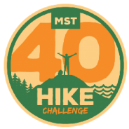
Friends of the MST Has announced plans to celebrate the Mountains-to-Sea Trail’s 43rd birthday during the month of September. This year, four new challenges help hikers and trail friends celebrate in a socially responsible and safe way. The trail runs 1175 miles across North Carolina, from Clingmans Dome in Great Smoky National Park to Jockey’s Ridge on the Outer Banks, and passes through areas of natural beauty, historical significance and cultural interest.
The three hiking challenges use Great Day Hikes on North Carolina’s Mountains-to-Sea Trail as a reference. The guidebook features 40 different day hikes from across the trail of varying lengths, and showcases many natural and cultural gems that are connected by the MST. The guidebook is published by UNC Press and edited by Jim Grode. The fourth challenge is a fundraising campaign. All are to be completed during September of 2020. Hikers are encouraged to hike following all local Covid-19 guidelines for safe outdoor recreation.
Challenge #1: Take a Great Day Hike. Walk one or many of the 40 hikes in the new Great Day Hikes on North Carolina’s Mountains-to-Sea Trail guide.
Challenge #2: 43-Kilometer Challenge. Hike one of the three designated 43-kilometer stretches of the MST in 24 hours to complete the 43K-Challenge. These stretches are:
• Mountains: Segment 5 -Jumpinoff Rock Overlook to Brinegar Cabin. Hike through rolling hills in Doughton Park and Brinegar Family homestead.
• Piedmont: Segment 10 – Rolling View Recreation Area to Yorkshire Center. Hike along the shores of Falls Lake.
• Coastal Plain: Segment 15 – Holly Shelter Game Lands, Surf City Bridge and Topsail Island. Hike through long leaf pine savanna and onto Topsail Island.
Challenge #3: Triple Crown. Complete each of the three 43K hikes in a 24-hour period during the month of September to complete the 43K Triple Crown.
Challenge #4: Raise funds for the MST. Friends has created a peer-to-peer campaign system for trail friends to help raise funds to build, maintain, protect and promote the MST.
More details about the 43rd Birthday Celebration and the Mountains-to-Sea Trail are available on www.MountainstoSeaTrail.org. Step after step, mile after mile, the MST was made for times like these.
Hiking is a wonderful way to see and experience the many wonders of the nation’s forests. As summer transitions into fall, the weather and scenery this time of year provide near perfect hiking conditions.
It is important to consider however, that the weather at higher elevations may be much colder, harsher and wetter, especially as the season changes.
The best way to make sure you and your family return home safely from any hike, no matter the length is to consider the Forest Service’s Hiking safety advice.
Obtain a trail map to help you plan your route based on your ability, available time and interest.
Make sure everyone knows what to do if they become lost or a medical emergency arises.
Wet surfaces can be a hazard and even more so if it’s on a slope.
Pack as light as possible. Leave the extras behind, but consider bringing essentials.
The N.C. Department of Health and Human Services advises all North Carolinians to practice the three Ws: wear a mask (when you cannot maintain 6 feet of distance), wait 6 feet between yourself and others, and wash your hands or use hand sanitizer frequently.
An athlete from Virginia has set a new women’s record for summitting all of the Adirondack 46 High Peaks. Alyssa Godesky finished her supported hike at the base of Giant Mountain a little after sunset on Thursday, clocking in at 3 days, 16 hours and 16 minutes.
Godesky began her journey at 4 am on Monday, August 17, 2020 near Tupper Lake. Over the next three and a half days, Godesky would cover 160 miles and more than 67,000 feet of elevation gain. She got just a few hours of sleep each night and took quick naps on the drive between trailheads. The “supported” type of hike she did meant she had a crew of 8 people who helped her refuel, travel, and gear up between trails.
Godesky said other hikers on the trail were incredibly supportive and encouraging, some of whom were aware of what she was trying to do. “I was totally surprised by that, and that was super, super fun. People would move to the side and be like, ‘keep going, keep going,'” Godesky added, which she said took her mind off of how badly her legs were hurting at times.
She said one of the toughest aspects wasn’t the hiking, but the weather. “I’m not a fan of being cold, so I had a couple of cold, wet mornings, which were probably the biggest mental struggles I had.”
Around 8 pm on Thursday at the base on Giant Mountain, Godesky stopped her GPS watch, clocking in at 3 days, 16 hours and 16 minutes. Godesky said her body is now in recovery mode. “Overall, I’m just super stoked and really happy.”
The Colorado Trail runs from Waterton Canyon clear across the state to Durango – 485 miles of mountain passes and adventure that you certainly need to have a good reason to finish.
Patricia Cameron has a reason. “I’m not doing it with the lightest gear, not doing it the fastest, but I’m still out here,” she said.
Cameron is the executive director of a nonprofit called Blackpackers. It addresses the economic issues that come with exploring the great outdoors and encourages a more diverse group of people to see what Colorado has to offer.
“People who have or are experiencing backpacking know that the upfront costs of this type of activity can be tough,” Cameron said. “I know it was for me.”
Your #1 source for snow, land, and water sports reviews, in one place. Globo Surf.
Cameron, who is Black, has lived in Colorado for 26 years. She’s founded Blackpackers to help introduce minorities to the outdoors and subsidize the cost of gear, and even lend it out.
She’s been documenting her Colorado Trail adventure on Twitter and in Backpacker magazine, and said she’s been recognized on the trail.
A pair of experienced Smokies hikers will soon embark on a 900-mile challenge in the Great Smoky Mountains National Park with the goal of raising $60,000 for the park’s Preventative Search and Rescue program.
Nancy “Seal Mom” East and Chris “Pacer” Ford plan to start their Tour de Smokies on Saturday, Sept. 5, 2020 and will catalog the journey on East’s blog “Hope and Feather Travels.” Along the way, they’ll show hikers what it takes to properly train and prepare for such an adventure.
East and Ford are both experienced Smokies hikers, with East having completed two 900-Miler maps and Ford completing three. Completing a map means hiking all 900 miles of trails in the park.
Smokies ranger Liz Hall, GSMNP’s first emergency manager, said East and Ford’s fundraising effort for Preventive Search and Rescue will be important for the success of the program.
“The funds they are raising will be a huge help,” Hall said, who started her new role in June 2020. “Those funds will go directly to fund two seasonal rangers.”
The rangers will assist with rescues and be part of the Smokies’ increased preventative efforts. They will oversee a cadre of volunteers who will hike various areas in the park to help visitors make good choices about their hiking.
To donate, visit www.friendsofthesmokies.org, call 800.845.5665 or mail a check to Friends of the Smokies, P.O. Box 1660, Kodak, TN 37764.
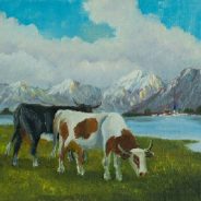
As the helicopter took off with the victim, Pfurtscheller learned that a 45-year-old hiker from Germany had been brutally assaulted, sustaining grievous injuries to her chest and heart. The farmer was well acquainted with her killers: Bea, Flower, Raven and his other cows.
Across the Alps, such attacks once were a shocking rarity. No longer. Amid the sweeping economic changes jeopardizing farmers’ future, the creatures that for decades have defined the region’s landscape and culture — bovine stars of tourism campaigns — have become liabilities.
Another hiker was killed a year after the German woman died in 2014, and another in 2017. Statistics aren’t kept by Austrian, Swiss, Italian or French authorities, but media reports of incidents have become increasingly common. A young mother, her baby strapped to her back, was trampled; both lived. A couple was run off a cliff, surviving despite tumbling 50 feet.
Nowadays, signs warning tourists in German, English, French and Italian are ubiquitous: Cross pastures at your own risk. Hotels display brochures on how to stay safe. Olympic skiers and famous actors help to raise awareness in TV spots and online videos, often stressing “the mountain pasture is no petting zoo.” A pilot project in Switzerland will soon launch an app that hikers can use to track the location of free-roaming herds and steer clear.
Ten years in the making, British Columbia’s Vancouver Island Trail (VIT) is Canada’s newest long-distance trail. It cuts across the spine of Vancouver Island for 770km stretching from the regal city of Victoria in the south to jagged sea-stacks of Cape Scott in the north.
Along the way, trail-users can immerse themselves in every facet of the island’s ecology and culture: old-growth forests, velvety mountains, bumpy logging roads, abandoned mining camps, colossal wooden railway trestles and the territories of 49 First Nations cultures. Inspired in part by the US’s Pacific Crest Trail, the trail has been dubbed a ‘pilgrimage into the wilderness.’
Developing the VIT has been a gargantuan undertaking. Juxtaposing well-established paths along erstwhile railway lines with rugged new sections that require good navigational skills, the task of threading the route together began in 2009 with the establishment of the Vancouver Island Trail Association (VITA).
A community-run non-profit group formed by experienced Canadian climber and hiker, Gil Parker, the VITA organizes volunteer trail-building expeditions as well as tackling more prosaic tasks such as liaising with private landowners and First Nations groups to iron out land access issues. It’s been an exhaustive process.
Indeed, the initial aim of inaugurating the trail in time for Canada’s 150th anniversary in 2017 proved to be overly ambitious. A year later, significant progress was made when Isobel Glover, a 20-year-old University of Victoria student, became the first hiker to complete the trail in its entirety (albeit with a bit of bushwhacking en route) and in July 2019 the VIT’s southern terminus was officially opened at a ceremony in Victoria’s Anderson Hill Park.
Getting out and around the wilderness is great. Doing it with your dog is even better. And best of all? Taking the time to make sure that both of you are properly outfitted for both convenience and safety. You’ll be happy you did when it turns out you need the stuff.
Hiking with your dog can be a wonderful experience, but you should definitely give a thought to the canine-essential gear you need. If you’re looking to have an outdoor experience with your pet, and minimize the hassle, then here’s some extra gear that’ll make life easier for both of you.
If you’re planning on a hike much longer than a half-hour, you should make sure you bring along some food for your canine companion. For shorter treks, a few treats are usually fine, on longer ones you may want to bring a serving or two of their regular food. Hiking burns a lot of calories, for both of you. That means you’ll need to replenish afterward, and your dog may get hungry along the trail’s edge.
Treats are also a good idea for dogs new to hiking. Use them as a positive reinforcement measure to encourage your dog not to do things like chase squirrels or going off into the brush alone.
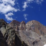
Awe-inspiring sights come easy to Rocky Mountain National Park. Elk gather in herds on the east side, while moose patrol the other. In between are bighorn sheep, mountain lions, and black bears. And that’s just the wildlife. The 265,807-acre park, located in northern Colorado, offers some of the best access to high-alpine terrain in the country, thanks to Trail Ridge Road—the highest paved highway in America—which tops out at a 12,183-foot peak, one of more than a hundred in the park taller than 11,000 feet.
The lower elevations, below 9,000 feet and referred to as the montane, are dominated by broad, grassy meadows filled with more than 350 miles of trails. The subalpine environment, from 9,000 and 11,000 feet, is comprised of natural lakes, boulders, and evergreen forests, and the majority of trails meander through these breathtaking landscapes. And at 11,000 feet, the alpine ecosystem begins: trees give way to windswept tundra, craggy peaks, and cirque glaciers, and the crowds dissipate, leaving you with the “roof” of the park mostly to yourself.
Rocky Mountain National Park is the third most visited park in the country, and it’s only getting more popular—visitation hit record numbers in 2019, pulling in nearly 4.7 million people. Parking lots in scenic areas like Bear Lake fill up before breakfast, and Trail Ridge Road is packed with minivans and RVs by 10 A.M.
If you have your heart set on seeing some of the park’s signature features, accept that crowds are part of the experience. If you want to minimize interaction with those crowds, get started as early as you can—essentially before dawn—and head to Grand Lake, on the western side; roughly 80 percent of all visitors enter through Estes Park, on the eastern side. If parking lots are full, don’t fret; the park has a good shuttle system that will take you to popular trailheads. Use it.
 I am Jeff Clark, founder of Internet Brothers, producer of this blog, and passionate about hiking. I live in Western NC near the Blue Ridge and Great Smoky Mountains. Pisgah and Nantahala National Forests are just out my door, so the content will focus on these areas, but let me know what you would like to see on the site.


Copyright © 2011-2023 Internet Brothers. All Rights Reserved. ISSN 2324-6057
Designed by Elegant Themes | Powered by Wordpress | Logo by Design Aspirations