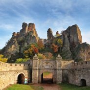
One of Bulgaria’s most interesting historical monuments is the Belogradchik Fortress. It’s located on the slopes of the Balkan Mountains, and the area’s phenomenal rock formations serve not only as natural protection but also as an integral part of the fortification itself.
It’s believed that these ancient rock formations were formed over a period of more than 200 million years, and they’ve now become unique obelisks, reddish sandstone castles, and oversized stone figures that soar high into the sky.
A fortress has existed here since Roman times, and it was originally built so that the highest part, known as the Citadel, used these gigantic rock formations for natural protection. To complete the fortress, thick fortified walls were added on a couple of sides, blending in with the rocks themselves. The walls are over 6.6 feet thick and rise 39 feet in height. The rocks, of course, extend much higher.
The ancient Roman fortress was later expanded by the Byzantines, Bulgarians, and Turks, and several towers, gates, and walls were added. Its present appearance dates back to the 19th century, when it was added to by the Turks. Now it’s the area’s most popular tourist attraction.
Hong Kong is dense with trails criss-crossing the territory. There are the major ones, like the MacLehose, Wilson, Hong Kong, and Lantau trails, then the minor ones and their tributaries.
What we may be less aware of is that many unofficially designated trails are at risk of disappearing for good. For centuries, residents of the territory have inscribed their marks onto its topography by walking the land over and over again.
As the city developed, trails took shape when construction teams erected pylons for overhead cables and built cable car systems up Lantau and at Ocean Park. But development also spelled the demise of some trails.
“Our problem is that most trails have never been designated and as a result there is no reinstatement obligation,” said Paul Zimmerman, the Southern district councilor and also the co-founder and CEO of Designing Hong Kong.
Without official status the Civil Engineering and Development Department is not actually required to ensure that the trails are reopened after work.
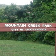
Chattanooga, Tennessee, may have the coolest backyard ever. Less than 10 miles from the city center, Mountain Creek Park will offer the community an urban recreation experience with 8 to 12 miles of natural surface trails for beginner to expert mountain bike riding, exceptional bouldering, and hiking trails for scenic exploration. With 800 feet of vertical drop and swarms of gnarly rock formations, the park will also provide some serious stoke with the first advanced downhill-style trails in the Chattanooga region.
Mountain Creek Park is the brainchild of six recreation and conservation groups, including the North Chickamauga Creek Conservancy (NCCC) and the Southern Off Road Bicycle Association (SORBA) Chattanooga, the IMBA Local mountain bike organization. Their collaboration demonstrates the power of cooperation and imagination.
“Chattanooga is a progressive, multidisciplinary recreation community of mountain bikers, climbers, hikers, and paddlers—one of the outdoor hubs of the southeast,” says Kevin Smith, president of SORBA Chattanooga. “We already have 100 miles of singletrack, and our ridership wanted some new advanced, downhill, gravity trails. It was a little daunting. We didn’t know if we could get such an ambitious venture done. But we worked with land managers, addressed the liability issues, and checked out what has been done in some nearby communities. Now with IMBA’s help in creating these advanced trails, Mountain Creek Park is going to be the crown jewel of Chattanooga outdoor recreation.”
This year on her birthday, Carolyn Burman decided to do a solo hike in one of her favorite state parks in Connecticut. She has magical memories of that trek. She grew up hiking it — her mother even went into labor with her while walking the path. She looked forward to a peaceful, reflective experience in nature. Instead, she found something else.
“There was so much garbage in the park,” 26-year-old Burman says. “Plastic seltzer bottles in the stream that floats by the trail, a Dunkin’ Donuts cup…. I go out on this joyful hike on my birthday, and all I see is trash.”
“I thought, ‘Oh, this is a sign. This is a reminder,’” she says. “I think we all can get really careless with waste. I felt like it was a sign from whatever power, ‘Hey. Remember? You gotta pick this up. You have to care more.’”
Now that Burman herself is a day-hiker again, she’s grown even more fierce about caring for trails. Hiking, she believes, is a spiritual practice, and part of that practice is keeping nature pure, doing her part to make things better. She works with trail upkeep groups like Keep Nature Wild to support this mission.
“Anyone can be an ambassador for them if you just go out into your local community and you clean up,” she says. “What you learn after the trail is that success is much less about the claim to fame and more about the slow and steady process.”
Many are those who say the Adirondacks are unique. That may be an overused word, but in numerous ways the region is distinctive, and in some cases even certifiably unique. Let’s consider some of those ways.
The Adirondacks are big. Not vertically, which is what most people think of when they hear the word “big” associated with mountains, but horizontally. Consider the Adirondack Park, for all intents and purposes the most useful packaging of the region.
The park is defined by its famous Blue Line, so-called because somebody drew the original line in blue pencil on a map about 125 years ago. (It has been reconfigured, usually to enlarge the park, several times since.) Inside that line are 6.1 million acres, give or take.
Simply put, the park is the largest of its kind—state, national, whatever—in the Lower 48. You could put Rhode Island in it and have enough room left over for Delaware and Connecticut. Toss those three aside and you could fit Maryland in. Or New Jersey, although local self-styled comedians always ask, “Why would you want to?” You could even squeeze Vermont in if you lopped a few acres off of the Green Mountain State. Yellowstone, Glacier, and Yosemite National Parks would go in nicely as a package.
The Adirondacks are old. This is open to ongoing scrutiny by the scientific community, but most geologists consider Adirondack bedrock to be among the oldest exposed rock in the world, at somewhere beyond one billion years.
Searching for the best places in Mississippi for hiking and camping? A University of Mississippi staff member knows exactly where to find the best trails.
Shannon Richardson, assistant director of campus recreation, has been supervising Ole Miss Outdoors for the past 14 years. Through her position, the Oakwood, Georgia, native has been on countless Mississippi trails.
“My parents were avid campers and hikers, and I grew up going to state and national parks and other natural areas,” Richardson said. “I’ve hiked trails from the Grand Canyon to the Appalachian Trail. My love for the outdoors continued through my undergraduate years at the University of North Georgia, located in the foothills of the Appalachian Mountains.”
What are the criteria Richardson uses in selecting hiking trails?
“I look for trails that are challenging, but enjoyable with beautiful scenery,” she said. “A ‘wow factor,’ like a peak or waterfall, is also a great perk.
“I like publicly managed lands best because the trails are maintained, it is safer and hiking on them leaves less impact on the environment than hiking on private or unmarked lands.”
For everyone from beginning to veteran hikers, Richardson offers some tips for those interested in taking the trails.
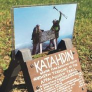
Appalachian Trail thru-hikers agree that the sign on Mount Katahdin in Maine signifies the pinnacle of a journey that changes you forever.
A local couple who completed their thru-hike in 2015 found there were signs along the way that held life-altering messages too.
Nate and Sharon Harrington, known to those on the trail as “The Hiking Vikings,” started their hike on Feb. 10, 2015 and reached the summit at Mount Katahdin on July 12. That’s 153 consecutive days of togetherness that, according to Nate, “sealed the deal.”
Many AT hikers start and end each day with a group but spend much of each day hiking solo. Nate and Sharon were never more than 10-feet away from each other the entire time.
They completed the hike on July 12, got married on July 22, moved to downtown Philadelphia on July 31 and Sharon started medical school on Aug. 3. Post-hike adjustment can be difficult for many thru-hikers, but they found life was just too busy for them to not keep moving.
Nate has also found multiple ways to give back to the trail since the 2015 experience. After their return to “civilization” Nate decided to create a miniature version of the sign at Mount Katahdin where thru-hikers pose. It is designed to hold the summit photo on top. When he posted a photo of his sign on Facebook, people started asking where they could get one.
From the perspective of a thru-hiker, there are few things that matter more than the meals to be devoured upon reaching the next town. After a few consecutive days of cold tuna, ramen, and beef jerky, hikers’ dreams are infiltrated with visions of bacon cheeseburgers, pepperoni pizzas, and Ben and Jerry’s.
When you’re few hundred miles south of Catawba, you start hearing the legend of The Homeplace. The vivid imagery painted by fellow hikers (many of whom haven’t even been there) caused your mind to go single-track in the direction of this southern style, old-fashioned restaurant. Many adjust their pace to assure you reach it during open hours. Needless to say, it will be one of your better decisions.
There are great restaurants along the entire length of the AT, but which ones can’t be missed?
As temperatures gradually warm up and flowers peek through the snow, Coloradans know what time of year has arrived. No, not springtime: hiking time.
Snow-wary outdoorsmen are beginning to dig out their hiking boots again, ready to stretch their legs across the state’s many trails. But with all those options, it can sometimes be difficult to choose which trail to set out on, especially because of lingering snow.
A new Colorado guidebook, “Base Camp Denver: 101 Hikes in Colorado’s Front Range”, comes out this month, and with it information on just over 100 day hikes. The author, Pete KJ, breaks down each hike, giving you details on every trail, including its difficulty, how kid-friendly it is and — crucial for this time of year — which season the trail is best for.
So using KJ’s breakdowns as a guide, here are five hikes that are best done in spring, whether you’re looking to get in shape for the summer or just want to appreciate a trail’s solitude before the hoards of summer hikers can interrupt it.
Great Smoky Mountains National Park officials announced several volunteer workdays during the month of April, 2019 on popular trails as the park prepares for the busy summer season. These opportunities are ideal for people interested in learning more about the park and the trails program through hands-on service alongside experienced park staff.
Volunteers will help clear debris from trails and work to repair eroded trail sections. Workdays will be held from 9:00 a.m. to 3:00 p.m. in North Carolina on April 6, April 20, April 22, and in Tennessee on April 5 and April 19. Prior registration is required.
Please contact Trails and Facilities Volunteer Coordinator Adam Monroe at 828-497-1949 or [email protected] for workday details and to register. Interested volunteers can also contact Monroe to learn about additional volunteer opportunities throughout the year including the ‘Adopt-a-Trail’ program and the Trails Forever ‘Working Wednesdays’ opportunities on Trillium Gap Trail beginning May 1 through August 29. These opportunities are perfect for those with busy schedules who would like to volunteer once a month.
For the April trail workdays, volunteers must be able to safely hike while carrying tools up to 4 miles per day and be prepared to perform strenuous, manual labor. After receiving proper training, participants will be expected to safely use hand tools such as shovels, rakes, loppers, and hand picks. Minimum age of participants is 16. Those under 18 must be accompanied by a responsible parent or guardian.
Volunteers will need to wear boots or sturdy closed toed shoes, long pants and appropriate layers for cold and inclement weather. Volunteers should bring a day pack with food, water, and rain gear. The park will provide instruction, necessary safety gear, and tools.
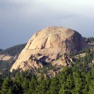
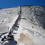
The route up Half Dome that John Muir climbed in 1875 is the same one you’ll ascend today — if you’re lucky enough to score the special permit required to hike Yosemite’s most recognizable feature.
After years of traffic jams on the cable-lined path up Half Dome — and several related deaths — the park put in place a permitting system in 2010. That eased the crowding somewhat, but in the intervening years, computer programmers essentially have rigged the online-permit system, making it exceedingly difficult for average tourists to land a climbing pass. In 2011, permits for the entire summer were sold out within five minutes of the first moment they became available online, according to the park superintendent at the time, Don Neubacher.
The park has since reviewed applications for Half Dome permits each year and found the success rate in the preseason lottery has been as low as 2 percent for weekend dates in 2017, according to Yosemite’s Wilderness Center, which supervises the permit process. The success rate can grow to 32 percent for people taking part in the daily lottery on weekdays, according to their review.
Once the cables are up, rangers said they will make available an additional 50 permits each day, the exact number based on cancellations and rates of no-shows, in a second lottery. For these, you put in for the permit two days prior to your date, and then find out the same day you applied (usually that evening) if you won. That’s where the odds of winning a Half Dome permit go up to 32 percent for weekdays, 14 percent for weekends.
For more than 150 years, the Heart of Wales railway has meandered through some of the most breathtaking scenery in Britain.
Now walkers can enjoy one of the UK’s longest fully-waymarked footpaths, loosely following the line, from Shropshire to Carmarthenshire. The last stage of the 141-mile trail opened this week.
One tourism expert said Wales was “ideal” for such walking tourism due to its nature and heritage, and the predicted rise in visitor numbers is expected to provide a “major boost” to the local economy.
“Wales is ideal for this type of tourism because one of its greatest assets is its diversity of countryside in close proximity. Combined with heritage railways such as this, Wales has the potential to be like Switzerland in attracting walker visitors.”
Heart of Wales Community Rail Partnership said: “With large numbers of visitors planning to walk the trail this summer, we are keen to put local cafes and pubs, family farmed produce and ‘off the beaten track’ B&Bs at the centre of the walking trail experience.”
National Park Week, running from April 20 through 28, 2019, has something for everyone. Join the National Park Service and the National Park Foundation for nine days of fun, including National Junior Ranger Day and National BARK Ranger Day. Visit www.NationalParkWeek.org for more information and a list of special events.
“National parks are sources of inspiration, recreation, and education for everyone,” said National Park Service Deputy Director P. Daniel Smith. “During National Park Week, a wide variety of creative programs and events across the country will showcase these amazing places and encourage everyone to visit a park.”
Park visitors can go on ranger-led hikes through hoodoos, prairies, caves, redwoods, wetlands, and sand dunes. There will be free guided tours of lighthouses, pueblos, battlefields, historic ships, forts, presidential homes, lower Manhattan, the French Quarter, and even a Nike missile site. Narrated bike, boat, train, and wagon rides are available. And it’s a great time to try out a new hobby such as bird watching, star gazing, painting, yoga, basket weaving, or hula dancing.
“National parks give us more than 400 reasons to celebrate together,” said National Park Foundation President Will Shafroth. “National Park Week is a great time to find your park with loved ones and to experience the stories and adventures that await in these treasured places.”
To get the celebration started, there will be a lively and engaging Twitter chat on Thursday, April 18 at 1 p.m. EDT. Join the conversation and share your favorite memories, tips, and stories about national parks using the hashtags #FindYourPark, #EncuentraTuParque, and #NationalParkWeek. From April 18 through 28, a special limited-time park ranger emoji will appear with the use of any of these haghtags on Twitter.
National Park Week begins with an entrance fee-free day on Saturday, April 20. One of five fee-free days scheduled in 2019, April 20 is also National Junior Ranger Day. Almost every park will have booklets for kids loaded with activities that can be completed to earn a Junior Ranger badge.
Hiking is now the fourth most-popular outdoor activity in the U.S., after running, fishing and biking, according to The Outdoor Foundation’s 2018 Outdoor Participation Report. The report noted that 44.9 million people hit the trails in 2017, up from 30 million in 2006. The biggest jump in participation came between 2015 and 2016.
Trail experts say no definitive study has been conducted to determine why hiking has exploded in popularity over the last few years. But many do believe “Wild,” the Cheryl Strayed book about the Pacific Crest Trail that was made into a movie in 2014, has at least played a part. For instance, The Pacific Crest Trail Association issued 7,313 trail permits in 2018, up from a mere 1,879 in 2013.
But it’s not just the PCT portrayed in Strayed’s book that is attracting hikers. Members representing all 11 of the country’s National Scenic Trails, of which the PCT is one, are reporting growth in trail traffic over the last five years, says Wesley Trimble, program outreach and communications manager for the American Hiking Society. In 2017, a record 3,389 hikers set out from Georgia to hike the Appalachian Trail (AT) which ends all the way in Maine. That’s 40 percent more than in 2015.
Trimble says in addition to the “Wild” effect, he believes hiking is increasing in popularity because more people are discovering the nation’s various trail systems and learning about the concept of long-distance hiking. “I also think the Millennials, and even Gen Z, are putting a lot more value on experiences than on monetary items and career advancement,” he says. “Cultural shifts have definitely played a role in the number of people getting out on the trails.”
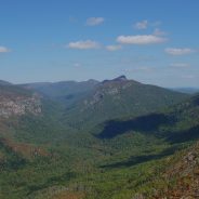
That faraway gaze sprinkled with a sparkle of rekindled joy in his eyes was becoming more familiar these days as he reflected and reminisced of past memories – memories of a simpler time when laughter, friendship, and camaraderie was never in short supply, especially when in the presence of those who did life together – a family in a sense. That family consisted of Dad and his close friends whom he would take to his favorite camping spot – Linville Gorge.
Life is a challenge and journey of its own, and sometimes a brief respite for the soul is the best medicine to assuage the burdens and cares of life and breathe in the fullness and vitality inherent in nature. Linville Gorge was a place of special memories that spanned over three decades, and now those memories were beginning to resurface in Dad’s own mind as he recognized the familiar gentle nudge to return to where those memories were born.
As he gazed at old pictures of him and his friends perched on a large slab of granite rock or sitting in a circle huddled around a toasty fire bundled in hoodies and smudged hiking boots, the fond sentimental memories returned, evoking the sense of nostalgia that was heightened by tangible reminders of old photographs, capturing the timeless sense of carefree spirits spent with lifelong friends.
Nature has a peculiar way of realigning our priorities, allowing us to appreciate the small moments made special by the company of those dearest to us and gently reminding us to slow down and instead relish the present moment. What better way to reflect on this than in a safe haven like Linville Gorge – a rugged refuge where one could silently marvel at the beauty of the stark landscape carved with the rolling Blue Ridge Mountains punctuating the outline of the horizon, silent spectators of the roaring Linville River winding its serpentine path through the canyon over a thousand feet below.
The Cradle of Forestry’s living history demonstrators and crafters will bring the Pink Beds community along the Cradle’s Biltmore Campus Trail to life by re-creating an early 1900’s community busy at work and play. Guests can visit the cozy King House to smell the wonderful aromas of open-hearth cooking, help with laundry without the modern conveniences, talk with blacksmiths as they work their trade, visit Mr. Jenny in the old general store and enjoy traditional music and dancing. Visitors can find crafters including wood working, broom making, sweet potato carving, horse plowing, and blacksmithing. The Cradle’s Opening Day Appalachian Folkways Celebration is a fun annual event.
David and Diane Burnette from Haywood County will demonstrate how their Percheron draft horses work the land the old way. Weather permitting, they will plow the Cradle’s heritage garden along the Biltmore Campus Trail and teach a skill that was once familiar to many. All ages will enjoy the chance to plow the old way with them!
The Cradle of Forestry will be open daily, 9 a.m. – 5 p.m., from April 6 – November 10,2019. At various times during the season, living history volunteers will demonstrate traditional crafts, music, and blacksmithing. The Giving Tree Gift Shop at the Cradle offers many of their creations as well as forest related books, maps, gifts and snacks. The Café at the Cradle will serve lunch from 11 a.m. to 3:00 p.m.
A full schedule of events is planned in 2019 including Cradle Community BioBlitz on April 27, May the Forest be with You on May 4, the Songcatchers Music Series Sunday afternoons in July, and Forest Festival Day on October 5. Visit www.cradleofforestry.com for the full event schedule, details and updates on interpretive programs and exhibits.
Admission to the Cradle of Forestry is $6.00 general admission, $3 for youth 4-12 years old and all federal pass holders such as America the Beautiful and Golden Age. Admission is free for children under 4.
The Cradle of Forestry is located on Hwy. 276 in the Pisgah National Forest near Brevard, North Carolina six miles north of Looking Glass Falls and four miles south of the Blue Ridge Parkway. For more information call 828-877-3130.
Just a few miles north of Camp Verde, Arizona, Wet Beaver Creek cuts a meandering course through high-desert plains and sparse mesas on its way to the Verde River. For thousands of years, the perennially flowing stream has been the life blood for peoples who settled near its green corridor.
The communities of Rimrock and Montezuma Lake are the most recent to evolve around the reliable water source. The tiny towns are a mix of ranch homes, antique shops, cafes and honey stands that sit at the hub of several important heritage sites off Interstate 17.
Until last year, out-of-town visitors had few reasons to do anything but drive through the creek-side hamlets on their way to somewhere else, but a new system of hiking trails now tempts travelers to park and stay awhile.
The Wickiup Mesa Trail System, which sits on 700 acres of Coconino National Forest at the far southeast edge of the towns, is the result of years of effort by the Beaver Creek Trails Coalition — a volunteer organization dedicated to creating and sustaining trails in the Beaver Creek area — in cooperation with the forest service.
Situated in a landscape of striking contrasts, the trails meander in a place of sprawling flatlands, fractured cliffs and mountain vistas. A strong undertow of earthiness guides visitors through spotty juniper-cedar forests, cactus-dotted grasslands, moist drainages and roughed-up washes on the highlands above the creek’s leafy riparian ecosystem.
Long ago the Zen master Yunmen (864–949) purportedly admonished his disciples: “If you sit, just sit; if you walk, just walk—but don’t wobble.”
It’s hard not to be scattered, especially in lives that are way too busy. Some of us may even wear our scurrying as a badge, as if it indicates that we’re important and doing impactful cutting-edge things in the world. When busyness becomes a virtue, we’re in deep trouble.
Those of us caught up in frenetic living require strategies to guide us to an alternative. On a hike or a walk in a park, when you sense yourself hurrying or tangled in thought as you clomp along, walk slowly for a few minutes. Better yet, stop for a minute. Take a few breaths. Listen. Do you hear any birds? What is this place saying to you? Is a breeze hitting your face? Can you smell the ground or any of the vegetation around you? What’s the taste in your mouth?
Take a few slow steps and really feel your shoe contacting the ground, your weight shifting, your back foot rising and swinging forward into the next step. If going steeply uphill, take a rest step by locking your back leg with most of your weight on it, pause, then step forward onto the front foot. This can be a form of walking meditation, what Japanese Zen practitioners call kinhin.
Checking in with each of your senses can enhance your awareness of your body and everything that’s happening around you there in the forest or in your garden. It may even help you begin to slow down and generate what psychiatrist and theologian Gerald May (1940–2005) called “the power of the slowing,” a slowing of both the body and the mind.
 I am Jeff Clark, founder of Internet Brothers, producer of this blog, and passionate about hiking. I live in Western NC near the Blue Ridge and Great Smoky Mountains. Pisgah and Nantahala National Forests are just out my door, so the content will focus on these areas, but let me know what you would like to see on the site.


Copyright © 2011-2023 Internet Brothers. All Rights Reserved. ISSN 2324-6057
Designed by Elegant Themes | Powered by Wordpress | Logo by Design Aspirations