
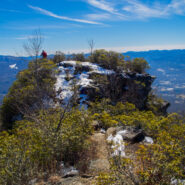
Pinnacle Park is an 1,100 acre tract of land owned by the town of Sylva in Jackson County, NC that was previously used as the community watershed. In 1991 it was leased to the Pinnacle Park Foundation for developing hiking trails that pass by streams, waterfalls, and beautiful long distance vistas. The Pinnacle, where the park got its name, is a large rocky outcropping...
Learn More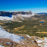
Acrophobia? Then you may want to stay home for this one, or at least don’t go all the way. That was my choice when my life-long fear of heights (that I thought I had conquered) kicked in. Devils Causeway, the destination for this hike on East Fork Trail in Flat Tops Wilderness, is an extremely narrow backbone atop a rocky ridge named the Chinese Wall that drops...
Learn More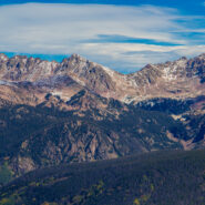
Bowman’s Shortcut is an easy-to-get-to trail that tops a ridge that enables views of three different mountain ranges — Sawatch, Gore, and Tenmile. You’ll start out climbing through a pine forest with occasional glimpses of the distant peaks through the trees, then reach the bald ridge and the magnificent views of some of Colorado’s highest...
Learn More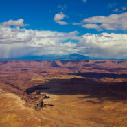
Canyonlands preserves a wilderness of rock at the heart of the Colorado Plateau in Southeastern Utah. Water and gravity, this land’s prime architects, cut flat layers of sedimentary rock into hundreds of canyons, mesas, buttes, fins, arches, and spires. At center stage are two canyons carved by the Green and Colorado rivers. Island in the Sky stands more than two...
Learn More
Nestled in the beautiful Blue Ridge mountains near Asheville, North Carolina, YMCA Blue Ridge Assembly is a full-service conference center situated on 1,200 acres of woodland beautified by mountain streams, wildflowers, ridges, valleys and spectacular views. What is little known about the property is the extensive hiking trail system. Primary among these is the High...
Learn More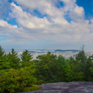
Carl Sandburg’s wife Lilian discovered the mountain farm named Connemara in the community of Flat Rock, south of Asheville, NC. From 1945, until his death in 1967, the famous American poet, biographer, and Pulitzer Prize-winning author lived and worked on the 264-acre estate. The family then sold the property and donated the contents to the National Park Service...
Learn More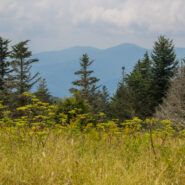
Most people who head out Clingmans Dome Road in Great Smoky Mountains National Park are there to climb the half mile to the summit of the 2nd highest mountain in the East. But here at Meanderthals, we aren’t most people. Below Clingmans Dome are trails that explore the ridges and drainage on the south face. Included among those are Forney Creek Cascade, a classic...
Learn More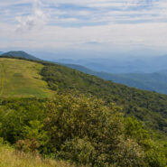
Northeast of Mars Hill, NC, the Big Bald Range straddles the Tennesssee/North Carolina border and marks the boundary between Pisgah and Cherokee National Forests. The Appalachian Trail (AT) follows the state line, as it does for nearly all its length between these two states. The destination for this hike is 5,516 foot Big Bald Mountain, another of the grassy balds that...
Learn More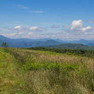
High above the community of Erwin, Tennessee, the Appalachian Trail follows the North Carolina / Tennessee state line through the Unaka Range. From a grassy bald ridge with the appropriate name Beauty Spot, to the summit of 5,184′ Unaka Mountain, the trail winds northeasterly for a 4-mile section through a continuously changing ecology. Stand on the bald with...
Learn More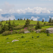
Located along the North Carolina/Tennessee state line, and where Pisgah and Cherokee National Forests merge, Grassy Ridge in the Roan Highlands is the longest stretch of grassy balds in the Appalachian Mountains. The Appalachian Trail navigates this stunning ridge, hopping from Carvers Gap to Round Bald to Jane Bald, and on to the 6,169 foot Grassy Ridge Bald. The...
Learn More
Standing guard along the state line, Max Patch Mountain is a grassy bald with fabulous panoramic views of the surrounding North Carolina and Tennessee Great Smoky Mountains. Oh, and by the way, the celebrated Appalachian Trail crosses its 4,629 foot summit. So far as Southern Appalachian summits go, this one is moderately short and easy, but you can make a day of it by...
Learn More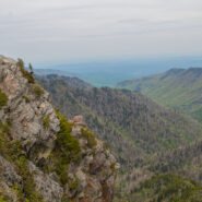
The Appalachian Trail straddles the Tennessee/North Carolina state line in Great Smoky Mountains National Park for more than 70 miles. A particularly scenic day hike on the AT is the four mile stretch from Newfound Gap to Charlies Bunion, a remote and rugged outcropping that sits on the ridge between the states. Along this sharp ridge you will pass magnificent views of...
Learn More
Southeast of the Cradle of Forestry National Historical Site is a remote area of Pisgah National Forest with trails that will take you along ridge lines with views of the Blue Ridge Parkway and Looking Glass Rock, then follow creeks and streams as they tumble down the mountains to the western end of South Mills River. You will encounter names like Squirrel Gap, Glady...
Learn More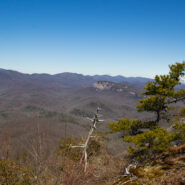
Cedar Rock is one of several granite pluton monoliths found in the Davidson River area of Pisgah National Forest. More difficult to get to than its nearby brethren, Looking Glass and John Rock, Cedar Rock has outstanding long distance views from both the east and west sides of its summit. You will have to work to get there, climbing nearly 1,700 feet from the valley...
Learn More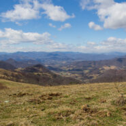
The Rough Creek Watershed is 870 acres of protected mountain land north of Canton, North Carolina, in Haywood County. This is privately held land, so there are rules for hikers and mountain bikers, but it is open to the general public. The trail system is more than 10 miles, and incorporates historical road beds with well maintained single tracks for foot and bike...
Learn More
Quite frequently in winter, the Blue Ridge Parkway will be closed for snow and ice. Not great fun for those who wish to drive along the beautiful ridges. Ah — but it’s the perfect time for hikers to get out on the trails that parallel the Parkway — like the Mountains to Sea. Between Pigeon Gap and Bennett Gap at miles 412-414 the Mountains to Sea Trail...
Learn More
The Black Balsam area of Pisgah National Forest is surrounded by Middle Prong Wilderness on the west, and Shining Rock Wilderness on the east. Some of the best hiking found in Western North Carolina lies in this high country just north of the Blue Ridge Parkway. At the end of Black Balsam Road at milepost 420 on the Parkway, the Ivestor Gap Trail will take you deep into...
Learn More
Between mileposts 423 and 424 on the Blue Ridge Parkway, Scenic Hwy 215 crosses at Beech Gap. If you head about 1/4 mile north on 215, the famous Mountains to Sea Trail crosses from the Black Balsam area into Middle Prong Wilderness. The MtS winds through an ever-changing forest that runs the gamut of evergreens found in the high country of Western North Carolina. Past...
Learn More
Hickory Nut Gorge runs from Bearwallow Mountain in the northwest to Lake Lure southeast. Included in its 10-mile length are majestic cliffs of granite, inspiring waterfalls and scenic wilderness that beckons to the explorer in you. Chimney Rock State Park, Florence Nature Preserve and Rumbling Bald all offer excellent hiking within the gorge. Up in the northwest corner...
Learn More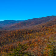
Pilot Rock is another of the granite plutons found in the Pisgah Ranger District of Pisgah National Forest. Not as spectacular as it’s more famous cousin, Looking Glass Rock, Pilot still offers remarkable views of the Blue Ridge Parkway and national forest, including the Cradle of Forestry National Historical Site. It’s a short mile climb of almost 700 feet...
Learn More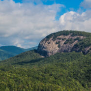
The always popular Cat Gap Loop Trail is a jumping off point for many great hikes within the Davidson River area of Pisgah National Forest. Included among them is the picturesque John Rock, one of the area’s plutons that stand over the recreation area. With views of the Fish Hatchery, Looking Glass Rock, Pilot Mountain and the ridges that run to Graveyard Fields,...
Learn More
Named after the Biblical mount where Moses first saw the Promised Land, Mt. Pisgah is the landmark that gave Pisgah National Forest its name. Located on the border of Buncombe and Haywood counties in NC, close to the point where Transylvania and Henderson meet them, the mountain is easily accessible via a hiking trail from the Blue Ridge Parkway. Mt. Pisgah is topped...
Learn More
Crowning the Mount Sterling Ridge, 5842 foot Mount Sterling is another of the tall peaks that give the Great Smoky Mountains their character. Located in the far eastern area of the national park in North Carolina, the 7-mile Mount Sterling Ridge rims the scenic Cataloochee Valley to the southeast. There are trails to the summit of Mount Sterling from every direction, but...
Learn More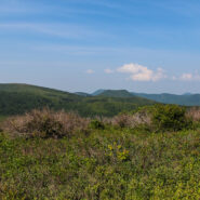
Milepost 420 on the Blue Ridge Parkway is where you will find Black Balsam Road. It’s a short drive to a spruce forest where the Art Loeb Trail crosses the road and heads up onto the balds. This is North Carolina high country. There are several mountains greater than 6000 feet with treeless summits, affording spectacular 360° views of the surrounding Blue...
Learn More
Pilot Mountain stands 5084 feet above the western edge of Pisgah National Forest, near the Blue Ridge Parkway and Looking Glass Rock. There are three ways to get to its summit, but the one I enjoy most is the section of the Art Loeb Trail from Gloucester Gap along Forest Road 475. It isn’t particularly long, but it is quite strenuous. You will get your exercise...
Learn More
Tucked away in the northeastern corner of DuPont State Forest in Western North Carolina, Stone Mountain is the highest point in the state forest at 3620 feet. Appropriately named for the exposed granite slab that traverses its summit, Stone Mountain offers a near 360° view of the surrounding terrain to winter hikers. Wintergreen Falls, though not as spectacular as...
Learn More
DuPont State Forest, in western North Carolina between Hendersonville and Brevard, was sold to the state by DuPont Corporation under favorable donation and conservation terms in 1996. Within its boundary are more than 10,000 forested acres and 80 miles of hiking and biking trails. Elevation ranges from 2300′ at Hooker Falls on the Little River to 3600′ on...
Learn More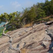
Perhaps the most popular hike in the Pisgah Ranger District of Pisgah National Forest, the Looking Glass Rock Trail is a good 3-mile leg stretcher to the top of the famous pluton. Probably not the most scenic hike is the area, but definitely popular because of ease of access, and a little less difficulty than some of the steeper monoliths. Looking Glass Rock is home to...
Learn More I am Jeff Clark, founder of Internet Brothers, producer of this blog, and passionate about hiking. I live in Western NC near the Blue Ridge and Great Smoky Mountains. Pisgah and Nantahala National Forests are just out my door, so the content will focus on these areas, but let me know what you would like to see on the site.


Copyright © 2011-2023 Internet Brothers. All Rights Reserved. ISSN 2324-6057
Designed by Elegant Themes | Powered by Wordpress | Logo by Design Aspirations