
Thompson Creek Trail climbs Thompson Ridge from Forest Road 1206 to a point just below the Pisgah Inn on the Blue Ridge Parkway. To the southwest it overlooks the Cradle of Forestry National Historic Site and the Pink Beds. To the east it crosses from Transylvania County into Henderson County and joins the Pilot Rock Trail along the Slate Rock Ridge for the descent...
Learn More
DuPont State Forest, in western North Carolina between Hendersonville and Brevard, was sold to the state by DuPont Corporation under favorable donation and conservation terms in 1996. Within its boundary are more than 10,000 forested acres and 80 miles of hiking and biking trails. Elevation ranges from 2300′ at Hooker Falls on the Little River to 3600′ on...
Learn More
Donated to the Carolina Mountain Land Conservancy by Dr. and Mrs. Thomas Florence in 1996, the Florence Nature Preserve is 600 acres on the slopes of Little Pisgah Mountain. With more than five miles of public hiking trails, much of them along a beautiful mountain stream, the preserve contains old growth forest, views of Hickory Nut Gorge, remnants of old cabins, and...
Learn More
Looking for a hike that includes streams and rivers, hardwood and conifer forests, plentiful rhododendron, and some climbing for good measure? Then the trails along South Mills River that embark from the Turkeypen Trailhead may be just the ticket. Situated in the southeastern corner of Pisgah National Forest, the Mills River Area is the largest in the Pisgah Ranger...
Learn More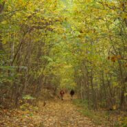
Chimney Rock State Park is one of the newest in North Carolina. The state acquired the land from private ownership in 2007, and the Carolina Mountain Land Conservancy continues to obtain additional parcels in the Hickory Nut Gorge to eventually expand the state park. The Rumbling Bald section of the park is separate from the more famous namesake, Chimney Rock. Because...
Learn More
Perhaps the most popular hike in the Pisgah Ranger District of Pisgah National Forest, the Looking Glass Rock Trail is a good 3-mile leg stretcher to the top of the famous pluton. Probably not the most scenic hike is the area, but definitely popular because of ease of access, and a little less difficulty than some of the steeper monoliths. Looking Glass Rock is home to...
Learn More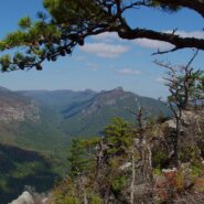
Most of the attention in Linville Gorge is focused on the northern features. There are more trails, higher peaks, and family recreation areas. But the south gorge is every bit as compelling and beautiful, with spectacular panoramic views up the gorge and westward to Pisgah National Forest and the Blue Ridge Mountains. Shortoff Mountain is a thousand feet lower than its...
Learn More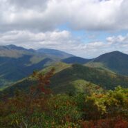
Montreat is a small community just north of Black Mountain, NC with a world renowned conference center, a college, and best for us, 20 miles of hiking trails that rival those in nearby Pisgah National Forest for quality and scenery. In particular, the Greybeard Trail is an exceptional workout that climbs more than 2300 feet to the summit of Greybeard Mountain on the Blue...
Learn More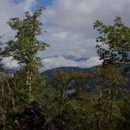
Kind of an unusual name for the mountain this trail is named after, but it is at 5,200 feet, so the snow comes earlier in the season, and more frequently than in the valleys below. North of Asheville, NC on the Blue Ridge Parkway, this hike is in the Craggy Gardens area. There are splendid views of the Great Craggy Mountains and the Black Mountains from the three summits...
Learn More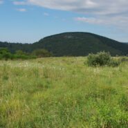
Flat Laurel Creek is in the area just north of the Pisgah Ridge and in between the Shining Rock and Middle Prong Wildernesses. It drains from Sam Knob and Little Sam Knob and runs to the West Fork of the Pigeon River. The trail that bears its name starts at the headwater and travels 3.7 miles around the west side of Little Sam until it meets Hwy. 215 and joins the...
Learn More
Perhaps it seems I’ve been spending quite a bit of time hiking in the eastern section of Shining Rock Wilderness in recent months. I can’t help myself. The terrain is wild, the forests ever-changing, the views exhilarating, and the exercise invigorating. The elevation changes dramatically — more than two thousand feet. The air is cool and refreshing...
Learn More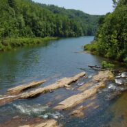
Gorges State Park was developed as a unique partnership of industry, the environmental community and the state of North Carolina. In 1999 more than 10,000 acres of the Jocassee Gorges in Transylvania County were purchased by the state from Duke Energy Corporation. The transaction created a 2,900-acre Gameland managed by the N.C. Wildlife Resources Commission, as well as...
Learn More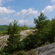
This is an extension of the trail report about the Panthertown Trail System in Nantahala National Forest from a previous post. When we explored Panthertown last November, we knew very little about it and kind of fumbled our way along the myriad of trails. Since, we have studied the trail system map and had a plan that included going to the top of Big Green Mountain, a...
Learn More
Looking at a trail map or topographic map, the area of this hike within Shining Rock Wilderness can be somewhat confusing. There is the Greasy Cove Prong, a creek that runs off of the Grassy Cove Ridge. The trail is called Greasy Cove, but it starts/ends at Grassy Cove Top. I think the guys who named the area may have had a touch too much huckleberry wine. Regardless of...
Learn More
This a continuation beyond the hike described in the Black Balsam Knob and Tennent Mountain trail report. The Art Loeb Trail continues down the north side of Tennent Mountain to Grassy Cove. There it meets the Ivestor Gap Trail for a lengthy hike into Shining Rock Wilderness. The area was named by the Cherokee for the large deposits of quartz found along what has become...
Learn More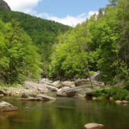
I will probably always be comparing Linville Gorge west rim trails that go down to the river to the Babel Tower Trail because that is the first one I hiked. Conley Cove is not quite as difficult because, unlike the straight-line trail that is Babel Tower, Conley Cove is a long continuous series of switchbacks. But, it is still a stern test of strength and stamina. This...
Learn More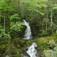
Sitting right along the Tennessee/North Carolina border in the far northeast corner of Great Smoky Mountains National Park is an enjoyable section of forest and creek side trails that navigate the Big Creek area of the park. The Appalachian Trail goes through the area, as does the Benton MacKaye Trail, named for the planner of the AT. There are mountains in the region as...
Learn More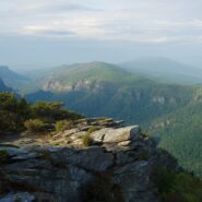
Linville Gorge runs north to south and has two entirely different rims. Trails on the west rim start on top and go down into the gorge to Linville River. Trails on the east rim go to a series of mountains that offer views into the full length of the gorge, and of the North Carolina Piedmont to the east and the Black Mountains to the west. There are a couple downward...
Learn More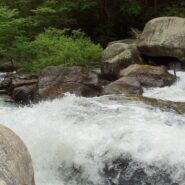
Green River Game Lands is a 10,000 acre tract in Henderson and Polk Counties owned by the state of North Carolina and maintained by ECO, the Environmental and Conservation Organization, a non-profit group in Hendersonville, NC. There are 16 miles of hiking trails available within the boundary of the Game Lands. The Green River Narrows is a haven for extreme kayaking,...
Learn More
Explorer William Linville and his sons were scalped by Indians in 1766 in what would eventually become known as Linville Gorge. I do believe I’d be fine with going through life not having anything named for me. The Linville Gorge Wilderness in Burke County, NC was one of the first protected areas in the country under the Wilderness Act of 1964. I’ve enjoyed...
Learn More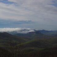
Frequently. That is how many times I have done this hike. So many, I’ve lost count. I love the western North Carolina high country, and this area along the Blue Ridge Parkway known as Black Balsam has nearly a dozen peaks over 5,800 feet elevation, with Black Balsam Knob being the highest at 6,214. This area has some of the highest hiking on the Parkway. Many of...
Learn More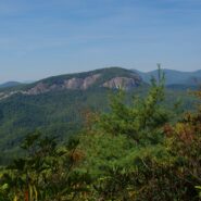
Coontree is a popular picnic area for familes along Davidson River in Pisgah National Forest, NC. What most of them probably don’t know though, is that there is a nice hiking trail just across Hwy. 276 from the parking area. It is very easy to get to, as it is only five miles from the crossroads in Brevard, NC. The trail itself is a loop with a connector at the top...
Learn More
Hidden deep within the Mills River area of Pisgah National Forest, the Pilot Cove/Slate Rock Creek loop trail is primarily a water feature hike. There are two notable waterfalls and several cascades on Slate Rock Creek, and views of Slate Rock through the trees. We encountered several creek crossings (some wading, some with log bridges), and a relatively young forest....
Learn More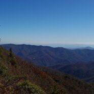
Cold Mountain gained national attention following the publishing of Charles Frazier’s Civil War era novel in 1997. Western NC hiking enthusiasts have known of its appeal for much longer. Cold Mountain is a real mountain that stretches 6030′ and is located in the Shining Rock Wilderness and Pisgah National Forest in North Carolina. You can reach the spur trail...
Learn More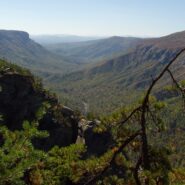
Formal protection of the Linville Gorge began in 1952, when the land was purchased with funds donated by John D. Rockefeller, Jr. When the Wilderness Act was approved by Congress and signed into law by President Johnson in 1964, the Linville Gorge Wilderness became one of the first formally designated Wilderness areas of the new National Wilderness Preservation System....
Learn More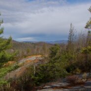
Panthertown Valley lies in Nantahala National Forest near Cashiers and Lake Toxaway, North Carolina. The Forest Service, along with the Friends of Panthertown, have created a trail system in combination with old logging roads that lead to waterfalls, cliffs, bogs, deep forest and spectacular overlooks of the surrounding valley. Panthertown has been designated a Blue...
Learn More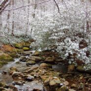
The Middle Prong Wilderness is west of North Carolina Hwy. 215 and north of the Blue Ridge Parkway. It is named after the Middle Prong of the Little Pigeon River that runs through the heart of the wilderness. This is remote territory in the high country near 6000 feet. Prepare yourself for heavy breathing — from exertion, and from natural beauty. Buckeye Gap Trail...
Learn More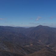
Between North Carolina Scenic Hwy. 276 and the Pisgah Inn is Fryingpan Mountain, one of a series of mountains along the north side of the Blue Ridge Parkway that help form the Pisgah Ridge. It sits at mile 410 on the parkway. A unique feature of Fryingpan is the 1940s era fire tower that affords spectacular views of the surrounding Blue Ridge. The tower is on the...
Learn More I am Jeff Clark, founder of Internet Brothers, producer of this blog, and passionate about hiking. I live in Western NC near the Blue Ridge and Great Smoky Mountains. Pisgah and Nantahala National Forests are just out my door, so the content will focus on these areas, but let me know what you would like to see on the site.


Copyright © 2011-2023 Internet Brothers. All Rights Reserved. ISSN 2324-6057
Designed by Elegant Themes | Powered by Wordpress | Logo by Design Aspirations