

This trail follows the McCullough Creek drainage up the gulch beneath the massive summit of 14,225′ Quandary Peak. It starts on an old mining road south of Breckenridge, CO, then changes to single track trail as it climbs the gulch. You’ll pass through pine and fir forest, get splashed by White Falls, marvel at the colorful granite, and count the variety of...
Learn More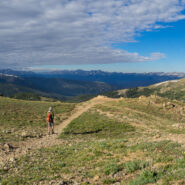
The easier of the trails at Loveland Pass, West Ridge surrounds two sides of the bowl that makes up the Loveland area and the I-70 corridor over the Continental Divide. Still, at 11,990 feet, this is no piece of cake for folks like me who are used to mountains no more than half the elevation. Several ski slopes are visible from the ridge. Look too for cute rodents to...
Learn More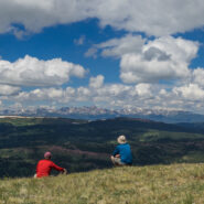
This marvelous example of Rocky Mountain vistas starts, oddly enough, directly beside Interstate-70 at Colorado’s 10,585′ Vail Pass. The trail winds through forest and meadow, then climbs steeply above treeline to Uneva Ridge, 1,500 feet above. Along the way you will enjoy breathtaking views of four distinct mountain ranges as you pass into Eagles Nest...
Learn More
Highway 4, west out of Leadville, CO offers a driving adventure that takes you past lakes, among a various assortment of summer wildflowers, and over a high mountain pass that tops out just short of 12,000 feet. I needed the drive rather than hiking the first day after recovering from a newly discovered adult-onset allergy to cashew nuts. The annual visit with my brother...
Learn More
I like to do most of my summertime hiking in the high country to avoid the heat, and the bugs. It’s like getting extra, added months of spring. So when the first week of summer rolled around, I thought of that section of Pisgah National Forest that lies between Shining Rock and Middle Prong Wildernesses, surrounded by the Blue Ridge Parkway, Hwy 215, and Black...
Learn More
Ho. Hum. Just another day at Roan Highlands. Now, obviously I’m being facetious. Roan Highlands is probably my favorite place to go in all of Western North Carolina, especially in mid-June when it is catawba rhododendron and flame azalea time. It’s exciting to hike on the iconic Appalachian Trail, the views of Tennessee and North Carolina on either side of...
Learn More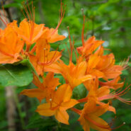
Remote. This little slice of Nantahala National Forest is truly far from anything. Once you are a mile into the woods from the trailhead, there is next to no evidence of human activity. It’s hard to know how many folks come here to hike, but there aren’t many boot prints in the mud. There are, however, plenty of deer tracks… and wildflowers. Wow, are...
Learn More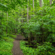
Baxter Creek Trail has a well-earned reputation as one of the hardest hikes in all of Great Smoky Mountains National Park. Starting at the Big Creek picnic area near Waterville, NC it climbs more than 4,000 feet over 6.2 miles, roughly 700 feet/mile. That will get your attention. Look for stunning forest scenes, waterways that keep the forest green, seasonal wildflowers,...
Learn More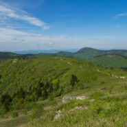
When looking for some WNC high country scenery and perhaps refreshing cool air on a warm day, one of the first destinations I think of is the Black Balsam area at milepost 420 on the Blue Ridge Parkway. There are half a dozen mountains here that stand above 6,000 feet, with encompassing 360° views from their treeless summits. This land that lies between the Shining...
Learn More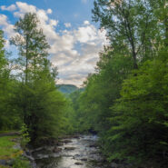
Perhaps the finest creek side trail in all of Great Smoky Mountains National Park, Middle Prong Trail actually follows Lynn Camp Prong. Lynn Camp and Thunderhead Prong join to form Middle Prong just below the trailhead. You will walk alongside Lynn Camp Prong for the entire length of this hike, passing dozens of swift cascades and two exciting waterfalls. Look for a wide...
Learn More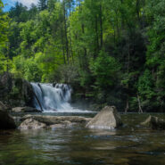
One of the most popular hiking trails in Great Smoky Mountains National Park, Abrams Falls at the west end of Cades Cove has the full Smokies package all in one. Here you can find rich, bountiful forest with a floor of colorful spring wildflowers, a rushing creek that provides refreshing nourishment for all the plants and wildlife, good exercise as you climb up and over...
Learn More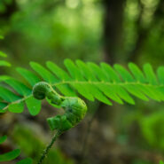
Pisgah National Forest comes alive in early May. It seems as though the greening happens almost overnight. Daniel Ridge Loop Trail is an amazing place to experience the changing of the forest from its sleepy, drab brown hues to the vibrant verdant that fills the senses. The creek along the pathway is the most picturesque in Pisgah Ranger District in my opinion, and the...
Learn More
Every April I like to make a two-day trip to the Tennessee side of Great Smoky Mountains National Park. I usually stay overnight at the Cades Cove Campground. It is a glorious time in the Smokies. The spring ephemeral wildflowers are busting out all over. The weather is warming and the days are getting longer. The rivers, creeks and streams are usually full of cool,...
Learn More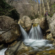
Yellowstone Prong has some of the most rugged terrain in all of the Pisgah Ranger District. Paralleling the Blue Ridge Parkway from Looking Glass Rock Overlook at milepost 417, and climbing the drainage from Skinny Dip Falls to Yellowstone Falls, this hike in, along, and above Yellowstone Prong may be the most challenging mile I have undertaken. You will scramble over...
Learn More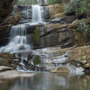
Some of the earliest wildflowers of the new season can be found on the Green River Game Lands near the North and South Carolina border. The elevation isn’t quite as high here as it is in most of the mountains of WNC, so the flowers get a little bit of a head start. Look for chickweed, rue anenome, wake robin trillium, blue and Canadian violets, robins plantain and...
Learn More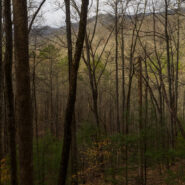
Deep Creek is one of many popular recreation areas found in Great Smoky Mountains National Park. Camping and picnicking are in abundance, as well as plenty of waterways for fishing and tubing. The assorted hiking trails also make it a fun destination for you and me. This hike, a combination of two different small loop trails affords the opportunity to visit the three...
Learn More
The Shut-in Ridge Trail and the Mountains to Sea Trail are one as they traverse the Blue Ridge from the North Carolina Arboretum to Mt. Pisgah. Along the way, there are several jumping on and off points where you can access this trail from the Blue Ridge Parkway, enabling short day hikes. One of these short sub-sections is along Bent Creek Gap Road at BRP milepost 400....
Learn More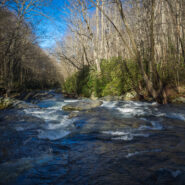
Elkmont is a nice area of the Smokies to visit in winter. It’s quiet, historic, alive with waterways, and offers views of the surrounding mountains through the leafless trees. Little River is beautiful as always, the climb up and over Cucumber Gap is invigorating, and the timeless cottages of Daisy Town along Jakes Creek harken back to a simpler time in the...
Learn More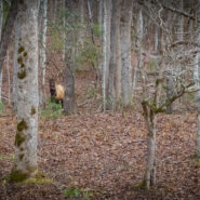
Cataloochee Valley in the Smokies is of course most popular during the green seasons. People come from far and wide to experience the wildflowers in Spring, the myriad of hiking trails in Summer, and the exciting elk rut and colorful foliage in Fall. But Winter too has its appeal. Perhaps the best reason to go to Cataloochee in winter is the solitude. The crowds are...
Learn More
The first time I went to Great Smoky Mountains National Park more than 15 years ago I knew it was someplace special. But it took me nearly 10 more years before I ever set foot on one of her trails. Work kept me busy and I had different recreational interests, but when I got serious about hiking around 2008, you couldn’t hold me back. Most of my early hikes were...
Learn More
The final day of our recent trip to New Mexico, my brother Dave and I returned to his home in Colorado. Along the way we stopped for some sight seeing in Los Alamos, NM, Pagosa Springs, CO and near Leadville, CO. When we originally left Colorado a few days before, the weather had been summer-like, and we had enjoyed the turning of the aspen trees to their brilliant...
Learn More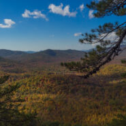
Starting at the former site of George Vanderbilt’s Buck Spring hunting lodge near Mt. Pisgah, this hike crosses the summit of Little Bald Mountain before dropping down the watershed to Pilot Rock, one of the many plutons found within the Pisgah Ranger District. The high country is home to thickets of mountain laurel and rhododendron, while various maples, oaks and...
Learn More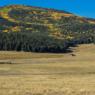
Valles Caldera is a 13.7-mile wide volcanic bowl in the Jemez Mountains of northern New Mexico near Los Alamos. About 1.25 million years ago, a spectacular volcanic eruption created this circular depression now known as the Valles Caldera. The Valles Caldera Preservation Act of 2000, signed by President Clinton, created the National Preserve. The preserve is known for...
Learn More
The Río Grande del Norte National Monument is comprised of rugged, wide open plains at an average elevation of 7,000 feet, dotted by volcanic cones, and cut by steep canyons with rivers tucked away in their depths. The Río Grande River carves an 800 foot deep gorge through layers of volcanic basalt flows and ash. Among the volcanic cones in the Monument, Ute Mountain is...
Learn More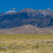
Great Sand Dunes National Park and Preserve protects the tallest sand dunes in North America, and a whole lot more. From the San Luis Valley floor to the crest of the 13,000 foot peaks in the Sangre de Cristo Mountains — the park and preserve contains ecosystems ranging from sand sheet to dunes to tundra — each supporting specially adapted plant, animal and...
Learn More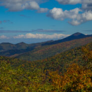
There aren’t many places in Western North Carolina better for Autumn leaf peeping than the Blue Ridge Parkway. On Monday, October 17, 2016 I set out to demonstrate that by taking a little tour between mileposts 410 and 420. But first I had to get there. I went up the Pisgah Ridge on Scenic Hwy 276, passing the Cradle of Forestry along the way. I arrived at the Cold...
Learn More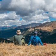
There’s a reason they call it Summit County. An old mining road climbs from Hoosier Pass above 12,000 feet and is surrounded by several of Colorado’s famous fourteeners. The first half of the road meanders through a spruce and fir forest with occasional views of the massive mountains that envelop the region. The rest of the way is above treeline, offering...
Learn More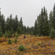
Fog and low-lying mist is very common in the Southern Appalachians. It is a product of the rainforest effect. Fog is highly unusual in the Rocky Mountains, but that’s what greeted Dave and I as we hit the trailhead to climb Shrine Ridge. It was somewhat of a dreary, forlorn scene as we walked from mountain bog to spruce forest to high meadow on our way to the...
Learn More I am Jeff Clark, founder of Internet Brothers, producer of this blog, and passionate about hiking. I live in Western NC near the Blue Ridge and Great Smoky Mountains. Pisgah and Nantahala National Forests are just out my door, so the content will focus on these areas, but let me know what you would like to see on the site.


Copyright © 2011-2023 Internet Brothers. All Rights Reserved. ISSN 2324-6057
Designed by Elegant Themes | Powered by Wordpress | Logo by Design Aspirations