

You can’t really tell from the overlook, but there’s a lot to like down in Swamp Canyon. For one, this is part of Bryce Canyon Wilderness, so it is definitely less crowded than the majority of the national park. There are great views of Wightman Bench and Swamp Canyon Butte from down in the canyon. Wildflowers and wildlife are abundant during the green...
Learn More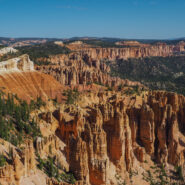
Bristlecone Loop, accessible from Rainbow Point at the southern-most end of Bryce Canyon National Park, meanders through a spruce-fir forest atop the highest portion of the park, reaching elevations over 9,100 feet. This short and easy stroll passes by bristlecone pines up to 1,800-years-old and experiences vistas reaching into Dixie National Forest and Grand...
Learn More
Golden hour is special for any place with picturesque scenic beauty, especially if you also happen to like photography. There aren’t many places more stunning during the golden hour — that time right after sunrise and right before sunset — than Bryce Canyon. There are even viewpoints named for these wonderful times… Sunrise Point and Sunset Point....
Learn More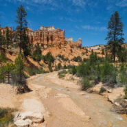
Arriving at Bryce Canyon mid-afternoon, Dave and I headed for the short Mossy Cave Trail to get our feet wet among the majestic hoodoos. This trail actually begins outside the park at the far northern reaches, then enters the park boundary on foot. The trail is a streamside walk up to a mossy overhang and small waterfall. Mossy Cave isn’t a cavern, but is a grotto,...
Learn More
The Snowy Range Scenic Byway crosses the Medicine Bow Mountain Range and includes nearly 30 miles of the Medicine Bow-Routt National Forest portion of Wyoming Highway 130. It passes between the towns of Centennial and Saratoga, but it’s what is in between that is spectacular. Originally a wagon road built in the 1870s, the road was paved in the 1930s and designated...
Learn More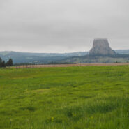
Devils Tower, an important landmark for Plains Indians tribes long before the white man reached Wyoming, was called Mateo Tepee or Grizzly Bear Lodge by the Sioux. A number of legends describe the origin of Devils Tower. “One legend tells of seven little girls being chased onto a low rock to escape attacking bears. Their prayers for help were heeded as the rock...
Learn More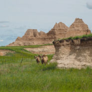
The Castle Trail is the longest in Badlands National Park, but can be broken up with three distinct trailheads. Medicine Root connects with Castle Trail at Saddle Pass and Old Northeast Road creating a loop of about five miles. The terrain is mixed grass prairie and arroyo, with views of the Badlands pinnacles throughout. Keep your eyes peeled for wildlife. It is...
Learn More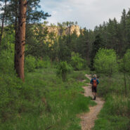
I think of the Hell Canyon Trail in Black Hills National Forest, South Dakota as two hikes. There’s the stroll through the canyon with lush trees and bushes and a wide assortment of colorful wildflowers. Then, there’s the path along the canyon rim that exposes the devastation of the 2000 Jasper Fire, the largest in Black Hills history. The undergrowth is...
Learn More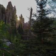
This is the hard way to get to the summit of 7,242′ Black Elk Peak, the highest in South Dakota. But, it affords you the opportunity to hike through the incredible Cathedral Spires, massive granite pinnacles that dominate the landscape in the Black Hills National Forest. Between the spires and the summit you pass through the rugged Black Elk Wilderness, named for...
Learn More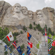
“Let us place there, carved high, as close to heaven as we can, the words of our leaders, their faces, to show posterity what manner of men they were. Then breathe a prayer that these records will endure until the wind and the rain alone shall wear them away.” — Sculptor Gutzon Borglum America’s presidential history is alive in stone. Majestic...
Learn More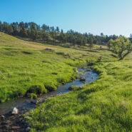
This hike in the heart of Wind Cave National Park combines two trails to make a 5-mile loop, and the two couldn’t be any more different. Centennial Trail takes you through lush meadows, and a rocky canyon lined with pine, while Lookout Point Trail experiences the wide open spaces of the South Dakotan prairie. Centennial follows the path of Beaver Creek through the...
Learn More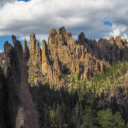
The Needles Highway in western South Dakota’s Custer State Park is more than a 14-mile road — it’s a spectacular drive through pine and spruce forests, meadows surrounded by birch and aspen with fields of bright wildflowers, and rugged, almost other-worldly, granite mountains. The road’s name comes from the needle-like granite formations which...
Learn More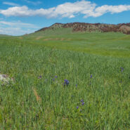
Located in the remote northern corner of Wind Cave National Park, Boland Ridge Trail crosses the wide open prairie, then a series of ridge climbs offer panoramic views of the Black Hills, the Red Valley, and the western South Dakota plains beyond. Because of the isolated nature, elk and bison are often seen along this trail. In fact, we had to cut this one about a mile...
Learn More
When you’re looking to get a good overview of the “above ground” features of Wind Cave National Park, what better way than to climb to the highest point. Fortunately, that’s easy to do with the Rankin Ridge Nature Trail. This one-mile loop takes you to an old retired fire tower with views into the Black Hills and as far away as The Badlands. Watch...
Learn More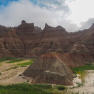
Back in the 1960’s when I was in my mid-teens, my family took a cross-country western vacation that included stops at many of the scenic and picturesque national parks along the way. Included among those was Badlands National Park, the first stop on our trip. I remembered all my adult life the fascination I had with the Badlands, and promised myself I would return...
Learn More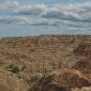
There are three short trails that share the same trailhead on the far eastern section of Badlands National Park. The Window and Door Trails are boardwalks that explore the spires and buttes of the Badlands Wall. Notch Trail passes through the Wall and offers a great view of the White River Valley. There is even a fun rope ladder that takes you to the canyon rim as you...
Learn More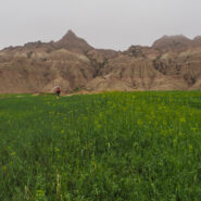
Our evening arrival to Badlands National Park coincided with a torrential storm that brought rain, wind and hail to the region. We learned the next morning that the campground was flooded, as was every arroyo in the park. We soon learned that the soft clay of the Badlands terrain does not mix well with lots of rain. Think quicksand — you sink inches with each step...
Learn More
What better way to spend May Day than wildflower hunting on Pisgah National Forest? We always think of the national park in the Smokies as being the go-to destination for Spring wildflowers in Western North Carolina. However, Pisgah National Forest is right up there. As you will see from the gallery below, there is quite the wide variety. I picked two destinations in the...
Learn More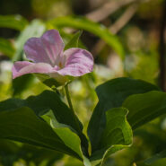
What to do if you’ve got half a day to kill on the Tennessee side of the Smokies? Well, if it’s April, the obvious conclusion is a wildflower hunt along Little River Road between Sugarlands and the Townsend-Y. On Saturday, April 21st, I had an invitation to the annual Great Smoky Mountains National Park Volunteers Appreciation Banquet, but it wasn’t to...
Learn More
This is one of my new favorite Spring wildflower hikes in the Smokies. The flowers are brilliant along both the Bradley Fork and Cabin Flats Trails. The Smokemont region of the Smokies is one of the most convenient, located just a short few miles northwest of the Oconaluftee Visitor Center off Hwy 441. It is four miles up Bradley Fork to Cabin Flats Trail, then another...
Learn More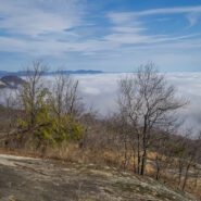
This park sits right on the cliff’s edge of the Blue Ridge Escarpment that drops down from the mountains in western North Carolina to the upcountry of South Carolina. The park is more than 3,000 acres of trails, lakes, cabins and camping. Pinnacle Mountain Trail is the most challenging within the park, with a climb that exceeds 2,300 feet. The lower section follows...
Learn More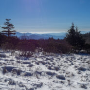
There was a major snowstorm over the Great Smoky Mountains on December 8-9, 2017, particularly on the Western North Carolina side. Seeing Roan Highlands covered in a blanket of snow has always been a goal of mine ever since the first time I walked the Appalachian Trail across Round, Jane, and Grassy Ridge balds. With that in mind, I set out for the Highlands on the...
Learn More
Another of the fun and exciting South Carolina state parks that line the Cherokee Foothills Scenic Highway, Keowee Toxaway offers two hiking trails that take visitors over a natural bridge and through the foothills of the Blue Ridge Mountains, land once traveled by Cherokee Indians. Much of the trail follows the shore of Lake Keowee through the healthy oak/hickory forest...
Learn More
Congaree National Park, located in the heart of South Carolina, is a land of towering trees, of floods and fire, of woodland paths and water trails used by people for more than 10,000 years. This rare, old growth forest became a national park in 1976. These ancient trees have witnessed wars, slavery, freedom, and destruction. There are 25 miles of hiking trails in...
Learn More
One of the more enjoyable trails I have hiked recently in the Smokies, Old Sugarlands follows West Prong of Little Pigeon River for a mile and a half, then turns to the east and ascends the western flank of the LeConte Ridge another 2.4 miles to a pastoral setting known as Cherokee Orchard. This trail receives surprisingly little use despite being surrounded by a hub of...
Learn More
There is no denying 2017 has been a disappointing year for fall foliage in the Smokies — so far. That’s why I titled this essay In Search of… you really have to look hard to find much beyond a few patches of yellow. The oranges and reds have been nonexistent. I started the day before dawn from Cades Cove driving toward Gatlinburg on Little River Road,...
Learn More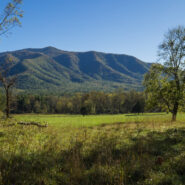
This was the first trail I hiked in Great Smoky Mountains National Park. It was back in 2008 or so, well before I started this website. So I thought it must be time, nearly 10 years later, to do it again and tell you about it. Rich Mountain Loop is a combination of three trails: Rich Mountain Loop Trail, Indian Grave Gap Trail, and Crooked Arm Ridge Trail. Most people...
Learn More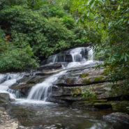
The air is nearly always cool at Caesars Head State Park in upstate South Carolina. It sits right on the edge of the Blue Ridge escarpment where refreshing breezes from the piedmont waft up and over the massive walls of rock. This hike is a casual stroll through hardwood forest on a sand and clay pathway to the Matthews Creek gorge and a suspension bridge over the...
Learn More I am Jeff Clark, founder of Internet Brothers, producer of this blog, and passionate about hiking. I live in Western NC near the Blue Ridge and Great Smoky Mountains. Pisgah and Nantahala National Forests are just out my door, so the content will focus on these areas, but let me know what you would like to see on the site.


Copyright © 2011-2023 Internet Brothers. All Rights Reserved. ISSN 2324-6057
Designed by Elegant Themes | Powered by Wordpress | Logo by Design Aspirations