
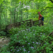
The Little River headwaters region of the Smokies was heavily logged in the early 20th century. As a result, a community called Elkmont sprung up in the valley below to support the lumberjacks and their families. Elkmont eventually became a mountain resort for the well-to-do of eastern Tennessee with its rustic cabins along the river. These days those quaint cottages...
Learn More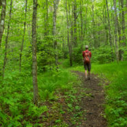
This delightful forested trail in the Heintooga section of the Smokies follows Bunches and Flat Creeks up Overlook Ridge to a perch high above Cataloochee Valley and Cherokee, NC. Few short trails in the Smokies are as memorable. The pathway is carpeted with a charming wispy grass that waves in the breeze and tickles your legs as you pass by. What’s not to love? My...
Learn More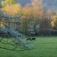
Perhaps the most popular feature in all of Great Smoky Mountains National Park, Cades Cove is a throwback to 19th century living. Think of it as an outdoor museum. Cades Cove is a wide, verdant valley surrounded by mountains that today is teeming with wildlife and spring floral beauty. The 11-mile Loop Road around the valley provides an opportunity for motorists,...
Learn More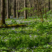
Without a doubt one of the most popular wildflower hikes on the Tennessee side of Great Smoky Mountains National Park, Whiteoak Sink is a basin surrounded by steep hills. In April each year this natural botanical garden comes alive with more than 30 varieties of native wildflowers right alongside the trail for all to enjoy. The name “Sink” comes from the...
Learn More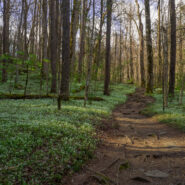
The Smokies can always be counted on for fulfilling the promise of spring renewal. One of the best spots for finding early blooms of exotic native wildflowers is on Porters Creek Trail in the Greenbrier section of the national park. Along the pathway is a diverse array of flowery goodness including the multi-acre mystical fringed phacelia garden, seemingly home to a host...
Learn More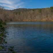
Named for an opportunistic traitor who supported the Crown during the Revolutionary War, Paris Mountain State Park was constructed by the Civilian Conservation Corps during the Great Depression. Richard Pearis owned 150,000 acres including what is now Greenville, SC and this state park north of the city. Once no more than a rural retreat, Paris Mountain is now a bustling...
Learn More
What is the first thing that comes to your mind when you think of the Smokies? Is it 6,000 foot mountaintop vistas that expand the imagination? Perhaps you think of the half-million acres of forest or the hundreds of varieties of wildflowers. There is one other constant in Great Smoky Mountains National Park, and that is water. Cataloochee Valley is surrounded on all...
Learn More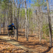
When you step on a trail at DuPont State Forest, you can usually tell pretty quickly if it was designed and built for mountain biking. Some tell-tale signs are banked curves and bumps, rails for tricks, and a smooth, hard-packed surface. Such is the case with Ridgeline Trail. DuPont State Forest is a haven for mountain bikers from all over the Southeastern United States,...
Learn More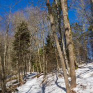
Thomas Divide is one of those ridge hikes that splits the heart of the Great Smoky Mountains Range. It is also one of the longer trails in the national park at near 14 miles, but you can do as much or as little as you wish for a day hike. The trail passes through a rich forest of Eastern hemlock, beech, birch and multiple varieties of maple. The crest also enjoys the...
Learn More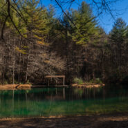
Located in the heart of DuPont State Forest, Three Lakes Trail does exactly what its name implies… it takes you to a trio of very picturesque lakes near Conservation Road. Lake Dense is an ideal stop for a family picnic. Lake Alford, really more of a pond, may be the most vivid and charming of all. The largest, Lake Julia, is breathtaking from every angle. Add to...
Learn More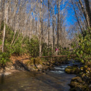
Bryson City, NC is located on the far southern boundary of Great Smoky Mountains National Park and hosts the Deep Creek and Lakeview regions of the park. Noland Creek Trail runs north/south off Lakeview Drive between Fontana Lake and the Noland Divide high above in the mountains. The trailhead is one mile north of the lake and heads in both directions. On this day Ken...
Learn More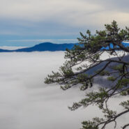
August 2005 saw the Carolina Mountain Land Conservancy and The Nature Conservancy purchase a 1,568-acre tract of land south of Lake Lure known as “World’s Edge” for $16 million with the intention of transferring the land as the first to be added to the new Chimney Rock State Park. World’s Edge contains a mile-long set of steep slopes on the eastern edge...
Learn More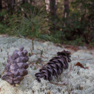
The far southwestern corner of DuPont State Forest offers a forested hike atop multiple plutons, past a retired rock quarry, and across a couple of gentle mountain streams. The oak trees are in abundance, as are white and longleaf pines. Look for the fascinating moss and reindeer lichen on the plutons as you gaze at the far away mountains of Pisgah National Forest. This...
Learn More
Historic Asbury Trail straddles the boundary between the Smokies national park and the Appalachian Ranger District of Pisgah National Forest. It is named for Methodist Bishop Francis Asbury who, in the early 19th century, brought his traveling ministry to this area that would eventually become a national park more than a hundred years later. It was also formerly known as...
Learn More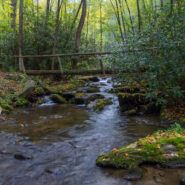
Located in the far southern region of the Smokies, near Fontana Village and the Little Tennessee River, Twentymile is an area of the national park that is a little less traveled. Primarily used by backpackers as a means of accessing remote park highlights like Gregory Bald or Shuckstack Fire Tower on the Appalachian Trail, Twentymile can also be enjoyed by day hikers or...
Learn More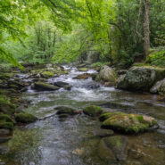
Joyce Kilmer-Slickrock Wilderness straddles the North Carolina / Tennessee line near the southern borders of the states, with about 75% of its 17,000 acres contained in NC. Six trailheads provide access to more than 60 miles of trail within the designated wilderness, which typically follow ridge tops or drop into the shady drainages. Perhaps the most atypical trail...
Learn More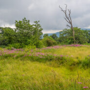
Deep in the remote southwestern corner of North Carolina where the scenic Cherohala Skyway climbs to meet Tennessee at Beech Gap, the Bob Bald Connector Trail (54A) climbs a ridge through Nantahala National Forest to Bob Stratton Bald. One of the lush mountaintop meadows the Southern Appalachians are known for, Bob Bald as it is called, straddles a boundary between...
Learn More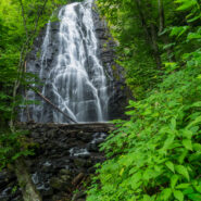
Crabtree Falls is a 70 foot cascade on Big Crabtree Creek, a short hike from the Blue Ridge Parkway. The creek drops over a black rock face with many small ledges, giving it a delicate web-like appearance. A trail descends 500 feet over the course of a mile as it leads to a footbridge crossing the creek at the base of the falls. In the Spring, an impressive array of...
Learn More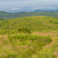
There is a notch between two wildernesses in the Pisgah National Forest high country. Shining Rock Wilderness is to the northeast, and Middle Prong Wilderness is to the west of this pie-shaped cut in the topology. In between are two bald mountaintops that exceed 6,000 feet elevation. To the locals the area is called simply… Black Balsam. The air is fresh (usually),...
Learn More
Deep in the heart of Shining Rock Wilderness is the namesake, a mountain made of quartz, standing more than 6,000 feet. On bright sunny days you can see the white quartz “shining” from miles away. The Cherokee called it Datsu’nălâsgûñ’yĭ, “where their tracks are this way,” that refers to a white rock that is said to have tracks of Tsul...
Learn More
When the Southern Appalachians are your home, the month of June simply isn’t complete without a visit to Roan Highlands for the annual rhododendron and azalea bloom. Like Julie Andrews sang years ago, “these are a few of my favorite things.” From the first time I set foot on Round Bald, I knew this was someplace special. The grassy ridge of the...
Learn More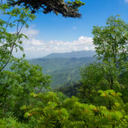
Clingmans Dome is the highest point in Great Smoky Mountains National Park, in the state of Tennessee, and along the Appalachian Trail. Standing 6,643 feet, it is also the third highest peak in the East, only 41 feet lower than the tallest. Several hiking trails surround the summit of Clingmans Dome, including the Forney Ridge Trail that heads south to the picturesque...
Learn More
Hot Springs, NC is an Appalachian Trail Community that sits along the French Broad River in the Appalachian Ranger District of Pisgah National Forest. The Appalachian Trail was built through Hot Springs more than seven decades ago, and today white blazes still mark the path through town and over the bridge across the river, before heading north up to the vista, Lover’s...
Learn More
Wild, rugged, and weathered — the Wichita Mountains Wildlife Refuge in central Oklahoma is a symbol of the old west standing at the threshold of modern times. The natural attractions of the refuge are many and varied. In addition to viewing and photographing wildlife in their natural setting, visitors find the lakes, streams, canyons, mountains and grasslands ideal...
Learn More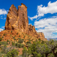
Most folks who visit Colorado National Monument view its red sandstone landmarks from Rim Rock Drive and its many overlooks. It’s convenient for peering deep into the canyons. However, like most places of interest, getting out of your car and putting your boots on the trail will give you an up-close-and-personal encounter with iconic features like Independence...
Learn More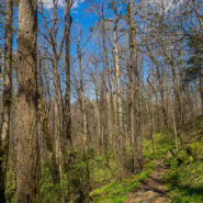
You know how some hikes can be kinda boring, then have a big reward like an outstanding overlook at the end? Or perhaps others will wind through a stunning forest only to peter out? Well, this hike located in the Greenbrier section of the Smokies has neither problem. The Porters Creek Trail is an exciting adventure from start to finish. I would describe it as a play with...
Learn More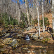
Sometimes the forest roads in national forests make the best hiking trails. Such is the case with FR 5031 in Pisgah National Forest. Located near Courthouse Falls on the far southwestern side of Pisgah, near the boundary with Nantahala National Forest, FR 5031 is a means of getting from a drainage bowl to Farlow Gap on Shuck Ridge. For mountain bikers, you could connect...
Learn More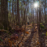
The Greenbrier section of Great Smoky Mountains National Park is filled with old growth forest, and with lots and lots of creeks draining into the valley from the high mountains of the Smokies above. The path of one of those creeks, False Gap Prong, takes it from near Laurel Top to Greenbrier Cove. A non-supported trail — otherwise known as a manway — follows...
Learn More I am Jeff Clark, founder of Internet Brothers, producer of this blog, and passionate about hiking. I live in Western NC near the Blue Ridge and Great Smoky Mountains. Pisgah and Nantahala National Forests are just out my door, so the content will focus on these areas, but let me know what you would like to see on the site.


Copyright © 2011-2023 Internet Brothers. All Rights Reserved. ISSN 2324-6057
Designed by Elegant Themes | Powered by Wordpress | Logo by Design Aspirations