
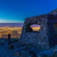
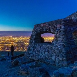
On clear evenings, the beacons on Mount Suppoa that bleep and flicker above an array of communication equipment are visible from many parts of the Phoenix valley. The spindly forest of red-lighted poles marks the highest point in South Mountain Park. The 2,690-foot summit is off limits to the public but equally swell sights can be had at nearby 2,330-foot Dobbins Lookout.
You could drive up to this Depression-era observation deck, but for those who prefer to sweat for it, the Holbert Trail provides a moderately difficult slog and rewarding discoveries all the way up. The hike is as much a trek through history as it is a respectable workout.
The trail winds up the north face of the Guadalupe Mountain Range, one of the three elongated ridges that comprise South Mountain. The others are the Gila and Ma Ha Tauk ranges.
The first history lesson comes within a half-mile of the trailhead where the route cuts through a box canyon of pre-Cambrian stone that’s older than primordial ooze.
The rocks that predate all life on Earth have survived eons of change, and their disintegrating, sun-baked surfaces have served as canvas for the etchings of ancient inhabitants including the Hohokam people who made many of the intricate symbols visible on boulders and cliff faces throughout the hike.
While images that look like water birds, turtles and sheep might be easy to understand, the meaning of artful spirals, crosses and cryptic figures may never be known. Be sure to scope out the surroundings as petroglyphs seem to pop up in the most unexpected places.
The following are paid links. As an Amazon Associate I earn from qualifying purchases.
 I am Jeff Clark, founder of Internet Brothers, producer of this blog, and passionate about hiking. I live in Western NC near the Blue Ridge and Great Smoky Mountains. Pisgah and Nantahala National Forests are just out my door, so the content will focus on these areas, but let me know what you would like to see on the site.


Copyright © 2011-2023 Internet Brothers. All Rights Reserved. ISSN 2324-6057
Designed by Elegant Themes | Powered by Wordpress | Logo by Design Aspirations