
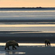
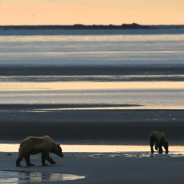
Ever wonder what the world looks like through the eyes of a brown bear? Researchers at Katmai National Park wonder, too.
To learn more, they initiated a collaborative, multi-year study examining the relationship between intertidal resources, coastal brown bear behavior, and human influences. As a part of this study, nine brown bears along the Katmai coast were outfitted with GPS location collars during the summer of 2015 to help better understand how they use intertidal resources like clams and mussels.
Two of the collars were equipped with video cameras that captured a bear’s-eye view at regular intervals. The videos reveal just what it is the bears are doing when they are out in the intertidal mudflats, wandering through meadows, or hiding in the brush. This location data, along with on-the- ground observations and the video clips will help answer questions like: How much time do bears spend in the intertidal zone? What do they do while there? What kind of intertidal resources are they feeding on?
The study has only gathered one year of data, some of which is shared through this story map, so these questions remain unanswered at the moment. But another two years of field data should start to shed more light on this important relationship between the land and the sea.
The website for this study is a remarkable production.
The following are paid links. As an Amazon Associate I earn from qualifying purchases.
 I am Jeff Clark, founder of Internet Brothers, producer of this blog, and passionate about hiking. I live in Western NC near the Blue Ridge and Great Smoky Mountains. Pisgah and Nantahala National Forests are just out my door, so the content will focus on these areas, but let me know what you would like to see on the site.


Copyright © 2011-2023 Internet Brothers. All Rights Reserved. ISSN 2324-6057
Designed by Elegant Themes | Powered by Wordpress | Logo by Design Aspirations