
Will political expediency doom one of the Lone Star State’s most beautiful natural wonders?
In West Texas, high in the Chinati Mountains — yes, there are mountains in Texas — it is hard to imagine a giant wall smack dab in the middle of this fantastic view. But there it is, in the thick of rugged desert beauty few Americans trek out to see: a gigantic, imaginary line, primed, if our enthusiastic president gets his wish, for a “big, beautiful wall.”
It’s one thing to contemplate an all-inclusive border wall in the abstract, as many Americans far from the border do; it’s quite another to actually go where the rubber will hit the road. And for more than 1,000 miles of the U.S.–Mexican border, that road turns out to be a river.
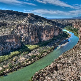
Here things get goofy: Where will the river portion of the wall go? On the Texan side of the Rio Grande, effectively blocking off river access and views? Down the middle of the river, just to be fair? Right through a hidden gem of a national park, which borders two massive Mexican conservation tracts and boasts daunting natural boundaries on either side?
The answer to that last question, at least according to a recent Department of Homeland Security report, is yes. Big Bend National Park, a Texas treasure and one of the most remote national parks in the continental U.S., hosts about 118 miles of the Rio Grande — and, therefore, 118 miles of the Mexican border.
It’s not easy to get to Big Bend, and to get out, visitors must pass through Border Patrol checkpoints on north–south roads. The DHS report, which prices the wall at $21.6 billion, slates Big Bend for the second phase of its construction.
The following are paid links. As an Amazon Associate I earn from qualifying purchases.
 I am Jeff Clark, founder of Internet Brothers, producer of this blog, and passionate about hiking. I live in Western NC near the Blue Ridge and Great Smoky Mountains. Pisgah and Nantahala National Forests are just out my door, so the content will focus on these areas, but let me know what you would like to see on the site.


Copyright © 2011-2023 Internet Brothers. All Rights Reserved. ISSN 2324-6057
Designed by Elegant Themes | Powered by Wordpress | Logo by Design Aspirations
