
Looking for an easy hike of less than five miles that will take you to several different waterfalls? Yes? Then this just might be the one for you. It starts on the ever popular Cat Gap Trail, passes two falls on Cedar Rock Creek and a whitewater cascade on John Branch before hopping on the Butter Gap Trail to follow Grogan Creek through Picklesimer Fields to the truly picturesque Grogan Creek Falls. All of that in only 2¼ miles one way. This is easy hiking too, climbing less than 500 feet over the full course. What are you waiting for? Get out there. I had great weather to enjoy hiking this circuit on Tuesday, September 30, 2014 beginning at 9:00AM and ending about 11:30AM. My plan was to take the west side of the Cat Gap Loop to Butter Gap Trail and on to Grogan Creek Falls, then return.
Hike Length: 4.7 miles Hike Duration: 2.5 hours
Hike Configuration: Out and back. Blaze: Orange, blue.
Hike Rating: Easy. The only difficulty is the slippery granite around the waterfalls.
Elevation Gain: 470 feet Elevation Start: 2,345 feet
Trail Condition: Good. Some exposed roots. Can be muddy after a hard rain. Be careful around waterfalls. Your family wants you to come back safely.
Starting Point: Western end of the State Fish Hatchery parking area.
Trail Traffic: I encountered two other pair of hikers and a large school field trip.
How to Get There: From Brevard, NC get onto Scenic Hwy 276 west into Pisgah National Forest. Go 5.2 miles, then turn left onto Forest Road 475. After a mile, turn left into the State Fish Hatchery and Wildlife Center. The trailhead is at the west end of the parking area.
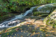
On your way up the west side of Cat Gap Loop you will pass two distinct waterfalls, known as Lower and Upper Cedar Rock Falls, then find a nice cascade right at the junction with Butter Gap Trail.
Directions for the first three quarters of this hike are the same as the one to Long Branch previously reported, so I’ll send you there first, then come back here to pick up the rest to Grogan Creek Falls.
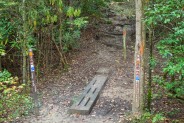
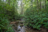
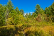
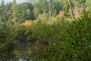
At the junction of Long Branch and Butter Gap Trails, instead of bearing right up Long Branch like in the previous hike, take the left fork to continue on Butter Gap. It’s only a half mile from this junction to Grogan Creek Falls. After passing through Picklesimer Fields and its moist, marshy ecosystem, once you reach this trail junction you’re back in the type of mixed hardwood forest that Pisgah is known for.
There is minimal climbing on this section of Butter Gap Trail, so it’s easy for everyone to navigate. I would recommend this area for all ages, but the waterfalls may be a little too dangerous for toddlers. Otherwise, bring the whole family. When you start hearing the rush of water plunging down out of the mountains, you’ll know you’re getting near.
I did a little bushwhack through the rhododendron a short distance before Grogan Creek Falls, thinking there might be another smaller falls below it. What I found, though, was more like a cascade and there were quite a number of downed trees fallen over the creek. Not an especially picturesque scene. So back up to the main trail I went for the final couple hundred yards to the falls.
Upon my arrival, there was what appeared to be a school field trip sitting on the trail. There were three chaperones who pleasantly greeted me, and about a dozen teens with various stages of interest plastered on their youthful faces. It was my good fortune that they were just leaving the waterfall, rather than just arriving. The chaperones were herding the group to resume their trek who knows where.
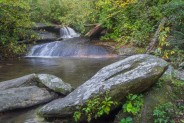
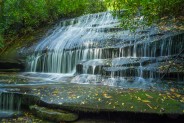
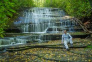
The base of Grogan Creek Falls is on the left, and down about 30 feet below the level of the main trail. It’s pretty steep to get down there, and when wet can also be slippery with mud. There are rhododendron branches and dog hobble to steady yourself as you work your way down the embankment. It’s safe to say you don’t want to fall on that mud because it will hurt, so take your time with the descent. You may be tempted to try to work yourself through the laurel to the top of the falls, but that is even more dangerous. Waterfalls, even smaller ones, are not something to mess around with.
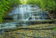
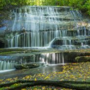
Once you safely reach the base of Grogan Creek Falls, you will see it’s a glimmering multi-tiered cascade that has shelves akin to a stairway. About 15 feet tall and 25 feet wide, it is moss-covered granite, as is the continuing pathway taken by Grogan Creek as it plunges further toward Picklesimer Fields. That rocky base makes it easy to walk around, though like any wet granite always watch out for slipping. In fall, wet leaves will add even more slippage hazard. The shelving construct makes the water stream downward like ribbons, each about two inches wide, an interesting effect.
I brought my tripod for pictures on this day, and now that the teen field trip had moved on, I had Grogan Creek Falls all to myself. I took shots from the side, from the front, up close, and farther downstream. The plunge arena is surrounded by rhododendron so it helped reduce the sunlight, always a plus when going for long exposures of waterfalls. I stayed for close to 30 minutes, so you can subtract that from the length of time required to complete this excursion.
Once satisfied, I climbed back up the muddy hillside for my return trip. If you continue southward on Butter Gap Trail, it will eventually take you to a meeting with the famous Art Loeb Trail, and from there to magnificent Cedar Rock. But on this day, my destination was only Grogan Creek Falls.
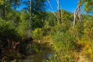
On the way back through Picklesimer Fields I went off-trail a bit to follow Grogan Creek through the wetlands. I’ve enjoyed doing this on previous ventures into the area. As I discovered though, early autumn isn’t the best time, as I got into briars and those hitch-hiker plants that attach themselves to your clothing. I was picking those things off the rest of the way back down Cat Gap Trail.
In summary, this hike is a great way to get out of the house and into the forest for an easy stroll alongside Cedar Rock and Grogan Creeks. By the way, you also just happen to be treated to several waterfalls that make the journey even more pleasant. You can be back to the start in as little as two hours, so you still have plenty of time for other things. This is definitely a four season hike, but be sure to watch your step around the waterfalls when icy in winter. It’s family friendly, but again, keep an eye on very small children around the waterfalls. Happy hiking!


The following are paid links. As an Amazon Associate I earn from qualifying purchases.
 I am Jeff Clark, founder of Internet Brothers, producer of this blog, and passionate about hiking. I live in Western NC near the Blue Ridge and Great Smoky Mountains. Pisgah and Nantahala National Forests are just out my door, so the content will focus on these areas, but let me know what you would like to see on the site.


Copyright © 2011-2023 Internet Brothers. All Rights Reserved. ISSN 2324-6057
Designed by Elegant Themes | Powered by Wordpress | Logo by Design Aspirations

Likes like a nice hike. I love finding waterfalls. They are probably one of my favorite pieces of terrain to watch.
Nice idea. I regularly hike John Rock, so this will be an interesting side trip.
Is the Cat Gap Trail to Cedar Rock Falls, et al, a more shaded hike? We want to be on a trail this weekend but it’s August and hot!
Yes, the majority of this hike is in the forest.
Thanks! 🙂
ummm, I can’t read any comments because the background is woodgrain and the font color fades into it. Is there a way I can be able to see these? I’ve created a username and validated my email…
Sorry, the comment management software made a change to the color of the text. I’ve taken care of that now. Thanks for the heads up.