
Southeast of the Cradle of Forestry National Historical Site is a remote area of Pisgah National Forest with trails that will take you along ridge lines with views of the Blue Ridge Parkway and Looking Glass Rock, then follow creeks and streams as they tumble down the mountains to the western end of South Mills River. You will encounter names like Squirrel Gap, Glady Branch, and Otter Hole as you traverse this long, but not particularly difficult loop. There’s something for everyone with long distance vistas, beautiful forest, and plenty of mountain water features. This hike occurred on Tuesday, April 2, 2013 from 9:20am to 2:35pm. Our plan was to take Funneltop Mountain Trail to Horse Cove Gap Trail, then join Squirrel Gap Trail as it descends to South Mills River. The loop would be completed on the South Mills River Trail.
Hike Length: 12.8 miles Hike Duration: 5.25 hours Hike Configuration: Loop
Hike Rating: Moderate, but long Blaze: Orange, blue, white
Elevation Gain: 1,370 feet Elevation Change: 910 feet
Trail Condition: Very good. Some creek crossings on Squirrel Gap Trail.
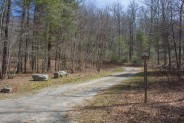
Starting Point: Funneltop Mountain Trailhead on Forest Road 476.
Trail Traffic: We did not encounter any other hikers on this day.
How to Get There: From the Brevard, NC junction of Hwys 64/276 take US 276 into Pisgah National Forest 11 miles. Turn right on Forest Road 1206 (Yellow Gap Road). Proceed approximately 3¼ miles to Forest Road 476 and turn right; Funneltop Mountain Trailhead is 0.7 mile on the left. Park at the campsites.
At nearly 13 miles, this one is longer than most day hikes that we do, but the area in Pisgah National Forest to be explored is so remote that you pretty much have to hike that far to make a loop of it. In reality these trails are ideally suited for mountain bikers, but we still had a great time on the ridge, in the forest, and following the river on foot.
Not far past the Forest Discovery Center on Hwy 276, Forest Road 1206 (Yellow Gap Rd.) takes off into the heart of the national forest. A bit more than three miles in, look for FR 476 on the right. On some maps this is known as South Mills River Road, on other maps as Wolf Ford Road. Less than a mile is the junction with Funneltop Mountain Trail.
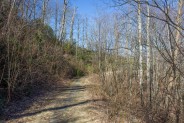
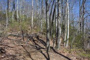
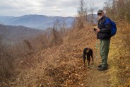
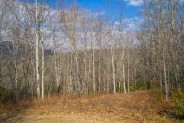
Really more of an old forest road than a trail, numbered 5018, this grassy double track begins a gradual climb up Funneltop Mtn. right from the start. You’ll be on this road for 3.9 miles, so even just an out and back would be a nice lengthy hike. You’ll skirt the southern shoulder of Funneltop as you rise about 600 feet over those four miles. After the first mile, mile and a half, the trail tops the ridge and offers great views to the south and west.
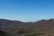
The first thing you’ll notice is the ribbon that is the Blue Ridge Parkway stretched out on its own ridge about 4-5 miles away. There is a clear view of the Pisgah Inn, perched at the base of the tower-topped Mt. Pisgah.
My companion is an avid biker in addition to his passion for hiking, and he was trying to talk me into trying out the hobby. Were I to take it up, this is the kind of trail/road I’d want to ride — very smooth and grassy, only moderate ups and downs, and picturesque vistas of the surrounding Blue Ridge. I broke it to him gently that my brother has been trying to talk me into mountain biking for nearly 30 years without success. I just prefer walking I guess.
The trail continues along this ridge for another two miles, turning casually to the east. Roughly three miles in, you’ll find the best overlook, with Looking Glass Rock to the southwest peering out from behind Clawhammer and Coontree Mountains. More directly west are the impressive 6000′ mountains in the Shining Rock Wilderness beyond the Parkway.
There’s one final, modest climb before reaching the dead end of Funneltop Mountain Trail. Here you will enter the forest, and find the Horse Cove Gap Trail marker on your right. You’re onto single track trail now as this orange-blazed connector path begins a descent to Horse Cove and Squirrel Gaps. On foot, there’s really nothing remarkable about this 0.7 mile trail, it’s merely a means of connecting with Squirrel Gap Trail. For the bikers, there are a few switchbacks and jumps to get your adrenaline pumping.
You can go west or north on Squirrel Gap Trail. The northern route eventually connects with the Turkeypen area of the national forest. On this day, however, we were heading west, and far, far away from any forest roads or other avenues of access. You might want to check your energy level at this point because you need to decide if you can make the entire 13 mile loop. This is the place to turn back if you have any doubts, and it’s still 4.6 miles back the way you came. So 4.6 miles back, or another 8.2 miles forward.
We had our lunch while conducting this debate with ourselves. There was another potential hazard to consider for us as well. We knew that we would have to cross South Mills River at the end of Squirrel Gap Trail. What we didn’t know was whether there was a bridge. We don’t mind river crossings, in fact, we had a great hike wading through this same river awhile back. That was summer. On this early spring day the air temp was about 42°F.
Taking inventory of our food and water supplies, we were good in that regard. We both still felt strong, as well as nourished after lunch. And, after much discussion, we also decided that if need be we were willing to strip down to bear feet and legs and ford icy-cold South Mills River. After all, we are Meanderthals. Onward it was.
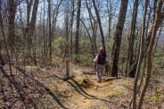
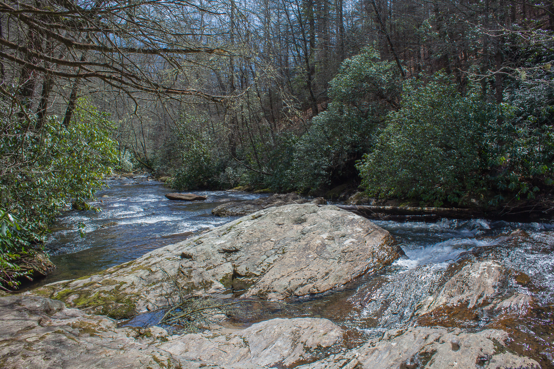
Squirrel Gap is a beautiful forested trail with blue blaze markings, lined with mountain laurel that was doing its spring thing and beginning to green nicely. The trail has a gradual decline as it meanders through locust and poplar, birch and of course, the ubiquitous rhododendron. With the late spring, still no buds on the trees though. We crossed several small, trickling mountain streams as we entered the watershed.
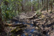
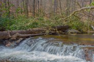
Upon reaching Squirrel Gap after about a mile, the trail joins Glady Branch, a larger stream that eventually feeds South Mills River. There are four crossings of Glady Branch that I recall, including one where you will rock and log hop about 10 yards to pick up the trail downstream. No sweat, unless it’s right after a heavy rain.
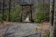
The total length of Squirrel Gap Trail from Horse Cove Gap to South Mills River is a bit over two miles. Near the end, the trail begins a series of switchbacks as it descends the watershed to river level. My friend was the first to see it. A BRIDGE! YAY! No freezing the tootsies for us. At river level there’s a nice flat bottom-land area with a few primitive campsites and a canopy of trees to protect from wind and rain. It would be a welcome, secluded spot for camping, but remember, it’s about 6-7 miles from the nearest access roads in either direction.
The wooden suspension bridge was constructed by the Youth Conservation Corps as a summer project in 1980, and sure was a relief for us. Youth Conservation Corps (YCC) began in 1974 as a program for high school teens that combined hands-on conservation work on public lands with environmental education. Federal support for the program terminated in 1981, but several state conservation groups have taken up the mantle since. In fact, North Carolina announced just this week that they are seeking applicants.
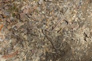
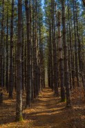
After pausing a few minutes to celebrate and take some photos, we crossed the swinging bridge and picked up the white blaze of the South Mills River Trail on the other side. You will climb moderately out of the river basin, then make a switchback to the west as the trail begins a snake-like winding up Grassy Ridge for the next mile. It’s easy going. I tend to tire when climbing, but even after eight miles I could handle this incline with no problem. Speaking of snakes, we encountered our first of the new season, a pair enjoying the warmth of the sun in the middle of the trail. You’ll come to a junction with the Buckhorn Gap Trail on your left at Grassy Ridge. Stay on South Mills River Trail.
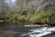
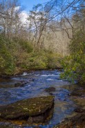
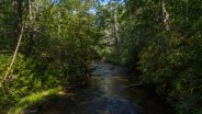
For me, the highlight of this hike is the last 3-4 miles along South Mills River. Once you top out at Grassy Ridge, the trail picks up the river again on your right, as both take a sharp turn northward. A quarter mile later, you’ll cross on a concrete bridge at Billy Branch, a scenic spot where the creek spills into the river. There’s a small pool about 3-feet-deep beneath the bridge that would make a refreshing swimming hole in the summer.
With the river now on your left, you’ll pass babbling and gurgling whitewater with easy access from the trail. There are huge boulders in the river to sun on, and the rush of wild water that fills the forest, and your senses. Breathe. Inhale. Exhale.
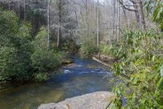
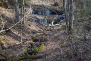
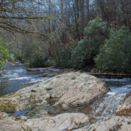
The next feature has the fanciful name Otter Hole. It’s a large pool totaling more than a half acre that is fed by a small slide waterfall. Surrounded by 50-foot tall gorgeous, but dying, hemlock trees, I imagine this to be a hugely popular spot with the teens during hot weather months. Shoot, if you’re hiking here in July, you should at least dip your toes. C’mon you know you want to.
The trail continues along the river for another half mile before reaching its end at the southern terminus of Forest Road 476. Here the river takes a decidedly westward turn and heads to Pink Beds. There is a large parking area with room for at least a dozen cars, as well as a handful of campsites for those who like their car-camping a little closer to civilization.
The final three-quarters mile to complete the loop of this hike is on FR 476 back to the junction with Funneltop Mountain Trail (5018).
To summarize, this is a long loop. Be prepared to allocate at least five hours to complete. We didn’t dawdle much at all, and it still took us 5.25 hours. I thoroughly enjoyed myself, but I doubt I’ll do the whole thing again as a day hike. However, it would be a terrific mountain bike ride, combining double and single track riding with plenty of sharp curves, creek crossings, and jumps for excitement.
Either end of this loop offers opportunity for very nice shorter hikes that may be just what you’re looking for. If you just take Funneltop Mountain Trail up and back, you’re looking at nearly eight miles with fantastic views of the Blue Ridge Parkway and Looking Glass Rock. If you drive on FR 476 past 5018 and all the way to the end, it’s a short half mile hike along the river to Otter Hole, or beyond to Billy Branch. If you get really adventurous, you could continue all the way to the suspension bridge, then return, a total of about nine miles.

Update January 30, 2015: We ventured out for a mid-winter visit to this long and glorious loop. We made it as far as the Horse Cove Gap junction where we stopped for lunch and watched a squall blow in out of nowhere. There really wasn’t any weather in the forecast, but you just never know what might happen in the mountains. We hurried to put away our unfinished food and quickly get out the rain gear. Just in time, because in a matter of moments it started with a cold, driving rain that quickly turned to sleet.
Thinking about where we were, it was four miles back the way we came, or eight miles to continue the loop. The sky looked pretty ominous so we chose to forego the most scenic part of the loop and hustle back to the car. The sleet eventually changed to half-dollar sized snowflakes for a couple minutes, and then back to rain. In total, the squall lasted about 20 minutes. By then, we were a third of the way off the mountain. Wouldn’t you know it, by the time we got back to the car, it was sunshine, blue sky, and puffy white clouds.
Here are a few more photos from our aborted attempt:
Update September 4, 2017: Ken and I enjoyed the South Mills River Trail off Forest Road 476 on Labor Day 2017. Pisgah National Forest was pretty busy with campers, picnickers and other recreationists, but this trail wasn’t overcrowded. We saw perhaps half a dozen others on our 9-mile round trip to the suspension bridge.
We trekked in a counter-clockwise direction for a change, starting at the trailhead at the dead end of FR 476, following South Mills River, passing by the junction with Buckhorn Gap Trail, and continuing on to the swinging bridge over the river. We enjoyed lunch on a log at one of the campsites, then returned the way we came.
Here are a few more photos of what we found along the way.


The following are paid links. As an Amazon Associate I earn from qualifying purchases.
 I am Jeff Clark, founder of Internet Brothers, producer of this blog, and passionate about hiking. I live in Western NC near the Blue Ridge and Great Smoky Mountains. Pisgah and Nantahala National Forests are just out my door, so the content will focus on these areas, but let me know what you would like to see on the site.


Copyright © 2011-2023 Internet Brothers. All Rights Reserved. ISSN 2324-6057
Designed by Elegant Themes | Powered by Wordpress | Logo by Design Aspirations


This hike looks amazing! I love checking out hikes in new places. I am moving to Kentucky in two months and might just have to make the short trip to NC to check this place out. Really beautiful and very different from the desert terrain I currently explore here in Nevada! Thanks for sharing your story!
Hi Rachel. Glad you stopped by. Hopefully you’ll look around this site more to see all the beautiful places that Western North Carolina has to offer. I’m likely biased, but I think we have some of the best hiking in the country.
While I haven’t had the opportunity to explore Nevada, I have spent a great deal of time in the wilderness in southern Utah. I love the desert southwest. It is a complete contrast to the forests, streams and waterfalls here in NC.
I rode to near the top of Funnel Top yesterday without a map. After reading your story, I am glad I turned around. I was camping down at the end of the road, so I at least had a blast on the return trip! There is surprisingly little info on this road/trail, so thanks!